December 29-31, 2015
The Sheep Hole Mountains are a small rocky range in the Mohave Desert just north of Joshua Tree National Park. Many people driving towards Joshua Tree from the north will undoubtedly catch a few glimpses of the range and its dramatic cliffs near the town of Amboy. I first visited the range in 2013, taking the easy standard route up to the range highpoint, but made a note of coming back and traversing the entire range.
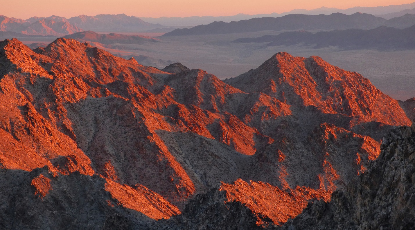
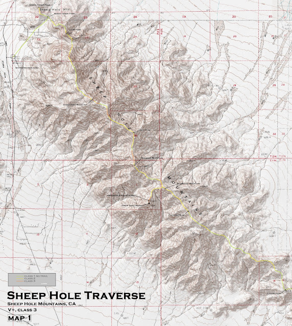
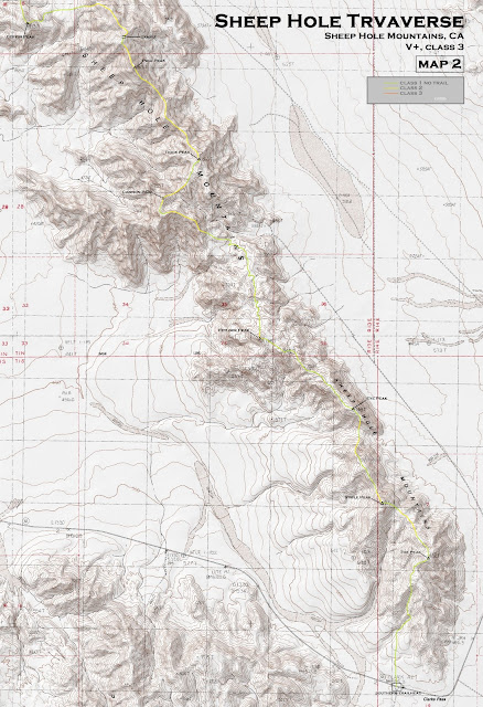
Even though the Sheep Hole Crest was only 22 miles long, it was comprised of what looked like miles of tedious rocks and boulders typical of the Joshua Tree area, making it a 2.5-day traverse. Since the range was a straight line, it would also be done in a point to point fashion, requiring a car shuttle. Since the northern side of the range looked the most tedious, we decided to do the route in a north to south direction starting from Sheep Hole Pass just off Amboy Rd and ending at Clarks Pass just off Hwy 62.
Getting to the trailhead (north): From Twentynine Palms, head 25 miles east on Amboy Rd to Sheep Hole Pass. There is a large tower installment at the pass just east (right) off Amboy Rd. Take the obvious short dirt road to a large parking area below the tower.
Getting to the trailhead (south): This location may be slightly tricky to find due to its nondescript location. From Twentynine Palms, travel just under 30 miles to the southern toe of the Sheep Hole Crest, just before Clarks Pass. There is a small dirt road splitting off to the south (right) which ends after a few hundred feet. Park here.
North trailhead coordinates (lat/lon): 34.239463, -115.720730
South trailhead coordinates (lat/lon): 34.073529, -115.558720
The table below includes every peak (traversing north to south) on the Sheep Hole Traverse. For unnamed peaks, I have dubbed names for them which are derived from sheep (to keep with the theme). These dubbed names are in quotes. Peaks without quotes are either officially named by the USGS or were found named by previous parties who had written them in summit registers.
| Order | Peak | Elevation | Topographic Prominence | Summit Coordinates (lat/lon) |
|---|---|---|---|---|
| 1 | "North Sheep Peak" | 2,968 ft | 346 ft | 34.253935, -115.711205 |
| 2 | "Loin Peak" | 3,372 ft | 305 ft | 34.246078, -115.701377 |
| 3 | Sheep Hole Mountain | 4,609 ft | 2,231 ft | 34.22668, -115.692114 |
| 4 | "Hoof Peak" | 4,317 ft | 260 ft | 34.216841, -115.677366 |
| 5 | Bilandko Mountain | 4,084 ft | 328 ft | 34.207472, -115.67728 |
| 6 | Sheep Benchmark | 3,876 ft (north summit) 3,874 ft (benchmark location) | 413 ft (north summit) 25 ft (benchmark location) | 34.195954, -115.67198 |
| 7 | Bilanders Mountain | 3,854 ft | 360 ft | 34.200303, -115.666144 |
| 8 | "Pastern Peak" | 3,785 ft | 235 ft | 34.193612, -115.657947 |
| 9 | "Coffin Peak" | 2,339 ft | 305 ft | 34.170233, -115.623186 |
| 10 | "Poll Peak" | 2,995 ft | 912 ft | 34.163842, -115.604475 |
| 11 | "Dock Peak" | 2,841 ft | 437 ft | 34.150489, -115.593166 |
| 12 | "Cannon Peak" | 2,726 ft | 252 ft | 34.145037, -115.599411 |
| 13 | "Fetlock Peak" | 2,486 ft | 370 ft | 34.124612, -115.582609 |
| 14 | "Eye Peak" | 2,454 ft | 170 ft | 34.114434, -115.566237 |
| 15 | "Stifle Peak" | 2,693 ft | 315 ft | 34.100735, -115.561237 |
| 16 | "Toe Peak" | 2,729 ft | 646 ft | 34.092793, -115.553062 |
Total Stats
22.4 miles 11,810 ft gain/loss
22.4 miles 11,810 ft gain/loss
Maps (Since Blogger does not let me upload this file at full size, email me at eric.jsc@gmail.com for a full sized version of this map)


Trip Report
Day 1: Sheep Hole Pass to Bilandko Mountain
Day 2: Bilandko Mountain to Poll Peak
Day 3: Poll Peak to Clarks Pass
Day 2: Bilandko Mountain to Poll Peak
Day 3: Poll Peak to Clarks Pass
Weather Forecasts
trailhead
all peaks
Peakbagger Pages
North Sheep Peak
Loin Peak
Sheep Hole Mountain
Hoof Peak
Bilandko Mountain
Sheep Benchmark
Bilanders Mountain
Pastern Peak
Coffin Peak
Poll Peak
Dock Peak
Cannon Peak
Fetlock Peak
Eye Peak
Stifle Peak
Toe Peak
Summitpost Pages
Sheep Hole Mountain
trailhead
all peaks
Peakbagger Pages
North Sheep Peak
Loin Peak
Sheep Hole Mountain
Hoof Peak
Bilandko Mountain
Sheep Benchmark
Bilanders Mountain
Pastern Peak
Coffin Peak
Poll Peak
Dock Peak
Cannon Peak
Fetlock Peak
Eye Peak
Stifle Peak
Toe Peak
Summitpost Pages
Sheep Hole Mountain
Nice-looking traverse. Curious to know how much water you carried and what your pack weights were at the start. - Jim
ReplyDeleteEach of us carried roughly 2.5 gallons. It helped that the temperatures were cool (highs in the 50s, lows in the 30s).
DeleteHello Eric - big fan of your trips, some nice work! What gear did you take, from Sheep Hole Mtn high Pt, can't tell if class 3 or class 4. Thx, Phil Bates
ReplyDeleteIt is the intent to provide valuable information and best practices, including an understanding of the regulatory process. Kernbohrungen
ReplyDeleteI adore each of the content, I seriously liked, I would really like details about it, since it is quite very good., Cheers intended for talking over.
ReplyDeleteKernbohrungen