
home page
December 29, 2015
It was around 8:30am as the two of us set off from Sheep Hole Pass. We headed in a NNE direction for 1.1 miles, aiming for the lowpoint (which I had dubbed North Sheep Pass) between North Sheep Peak and Loin Peak. Once at the pass, we dropped our packs and did a quick scramble to and back from North Sheep Peak. The terrain was your typical loose class 2 rock and compacted dirt, with a few fun and easy class 3 options on the direct ridge.
looking northeast from the start

just below North Sheep Peak

looking south from North Sheep Peak


Back at North Sheep Pass, we picked up our heavy water-filled packs and trudged up southeast towards Loin Peak, which was pretty much all class 2 except for the last hundred feet of direct ridge which was easy class 3.


After Loin Peak, we dropped 300+ ft of elevation to the southeast, then began the long ascent towards Sheep Hole Mountain, the range highpoint. The initial 1,000 ft of gain brought us up to a plateau where Sheep Hole Mountain could be seen prominently to the SSE. The last few hundred feet of ridge before the plateau turned to large class 5 blocks directly on the crest, but could be easily bypassed 20 ft below on class 3 rock.


The last 300 ft to Sheep Hole Mountain involved some tedious weaving between large boulders, requiring some class 3 and leaping from boulder to boulder.


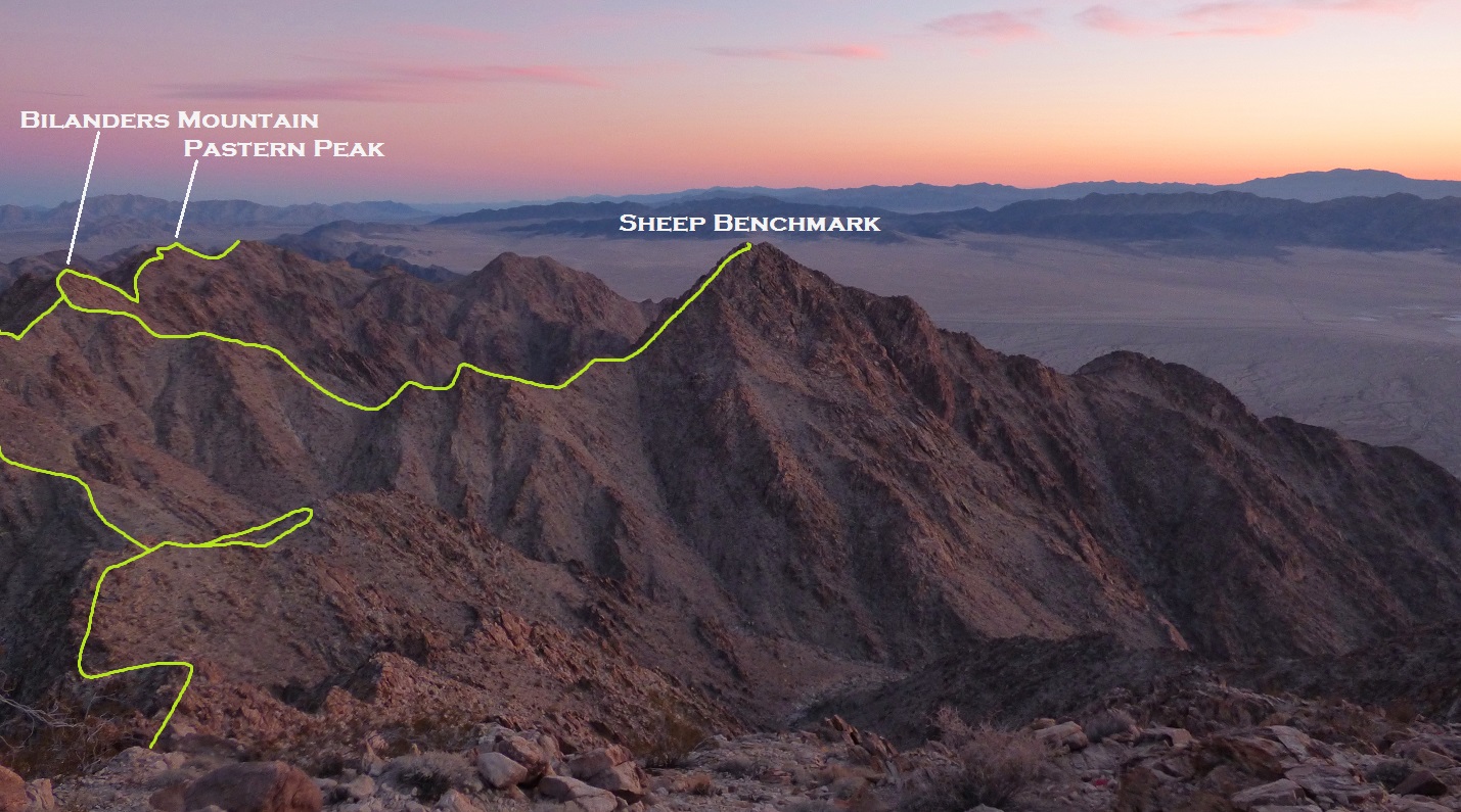
It was around 1:40pm as we reached Sheep Hole Mountain. Two peaks away to the south, we could see our goal for today: Bilandko Mountain. Without further ado, we began descending the rocky southeast side of Sheep Hole Mountain.
views from Sheep Hole Mountain


For the next hour, we weaved in between large class 3 sections of boulders interspersed with short Sandy plateaus. Eventually Daria got too sick of it and ended up dropping several hundred feet to the east, sidehilling on less bouldery terrain directly towards the low point between Sheep Hole Mountain and Hoof Peak. Since sidehilling is my worst nightmare, I remained more or less on the ridge, dropping slightly to the west when the Crest became too blocky.


Upon reaching Hoof peak's northwest ridge, the boulders vanished, and we made quick work of the class 2 ridge, arriving at the summit at 3:40pm.


view west from Hoof Peak

south

From here, Bilandko Peak looked really close to the south, but its serrated-looking north ridge had me thinking that it was not gonna be a quick skip and hop over to it.

Descending Hoof Peak's south ridge was pretty straightforward with its cruddy loose class 2 (except for a very short class 3 downclimb right below the summit). Upon reaching the base of Bilandko's north ridge, I could already make out the serrations above. I scrambled up a very crumbly class 3 headwall, then continued along the ridge for roughly 100 ft and noticed that it was seemingly about to cliff out. Pressing further onward, I noticed that the ridge would go, but continuing would involve a 10 ft class 3+/low 4th downclimb on loose and exposed terrain, ending on a gradually leaning slab. I went for it, noting that the downclimbing itself wasn't that difficult, but the heavy pack made the move bulky and awkward. After downclimbing, I followed the remaining class 2-3 ridge to the summit to find a register placed by Andy Smatko in 1981.
starting up Bilandko's north ridge

fading light


looking south from summit
register

It was now just after sunset and I needed to find a place to camp. Just 50 ft south of the summit was a gently sloped area that would serve as an OK site. I quickly set up the tent and then walked around, trying to see where Daria was. 45 minutes later, just as it was getting completely dark, the light of a headlamp could be seen bobbing up and down on the class 2-3 ridge below. Shortly afterwards, she reached the camp, breathing heavily. The last hour had not been friendly to her. It turns out that she had reached the class 3+/low 4th downclimb, decided to toss down her pack to make the downclimb, and ended up having the pack roll 400 ft off the slanting slab and down a gully before catching on a bush and bursting open. She descended to the pack, finding one of the pouches ripped open and a bottle of mayonnaise which had exploded all over everything.
We organized our stuff and began cooking dinner. Daria cursed as she fumbled around her pack, pulling out various items encased in mayonnaise. The steady wind that had been persistent throughout the day had finally began dying down. Without wind to disperse the air, everything around camp began smelling like mayonnaise.
go to day 2
No comments:
Post a Comment