
December 16, 2015
To the west of Borrego Springs in San Diego County are a jumble of ridges rising between 1,000 and 6,000 ft. I mapped out two traverses in this area, with the middle fork of Borrego Palm Canyon dividing both prominent ridge systems. For this particular traverse, I turned my attention to the northern ridge system, which included the prominent peaks of Indianhead, Cody Benchmark, and Pike Benchmark. My plan was to start traversing from Borrego Palm Canyon Campground in Borrego Springs in the dark, timing it so I would reach the summit of Indianhead by sunrise. From there, I would continue traversing up and over the remaining 15 peaks which when connected, formed a large "U" around Henderson Canyon.
Getting to the trailhead: From Borrego Springs, head west on Palm Canyon Dr to the Anza Borrego State Park headquarters (just before Palm Canyon Dr ends). Across the street from the headquarters is a road splitting north marked "camping." Take this road for a few miles to a parking lot at the western end of Borrego Palm Canyon Campground.
Trailhead coordinates (lat/lon): 33.270285, -116.418170
The table below includes every peak (traversing clockwise) on the Borrego Traverse. For unnamed peaks, I have dubbed names for them which are derived from the names of nearby towns and terrain features. These dubbed names are in quotes. Peaks without quotes are either officially named by the USGS or were found named by previous parties who had written them in summit registers.
| Order | Peak or Benchmark | Elevation | Topographic Prominence | Summit Coordinates (lat/lon) |
|---|---|---|---|---|
| 1 | Indianhead | 3,980 ft | 760 ft | 33.29253, -116.430264 |
| 2 | The Knob | 3,490 ft | 160 ft | 33.298969, -116.43995 |
| 3 | "Henderson Point" | 3,820 ft | 30 ft | 33.302660, -116.443548 |
| 4 | "Ignacio Peak" | 4,445 ft | 345 ft | 33.306375, -116.454749 |
| 5 | Palm Mesa High Point | 4,660 ft | 480 ft | 33.309924, -116.463751 |
| 6 | "Fork Division Peak" | 4,824 ft | 324 ft | 33.308043, -116.483123 |
| 7 | Cody Benchmark | 5,586 ft | 366 ft | 33.304267, -116.496603 |
| 8 | Norte Benchmark | 5,472 ft | 207 ft | 33.304242, -116.505075 |
| 9 | Phil Benchmark | 5,445 ft | 30 ft | 33.305229, -116.504708 |
| 10 | Dry Benchmark | 5,404 ft | 100 ft | 33.304386, -116.505129 |
| 11 | Army Benchmark | 5,491 ft | 0 ft | 33.310859, -116.501684 |
| 12 | Pike Summit | 5,660 ft | 680 ft | 33.313774, -116.496943 |
| 13 | Pike Benchmark | 5,571 ft | 40 ft | 33.313685, -116.494874 |
| 14 | "Deering Peak" | 4,780 ft | 182 ft | 33.315126, -116.482179 |
| 15 | "Bennis Peak" | 4,480 ft | 280 ft | 33.324499, -116.462157 |
| 16 | "Galleta Point" | 4,155 ft | 195 ft | 33.33415, -116.452203 |
Total Stats
22.2 miles 11,190 ft gain/loss
Map (Since Blogger does not let me upload this file at full size, email me at eric.jsc@gmail.com for a full sized version of this map)

Trip Report
22.2 miles 11,190 ft gain/loss
Map (Since Blogger does not let me upload this file at full size, email me at eric.jsc@gmail.com for a full sized version of this map)

Trip Report
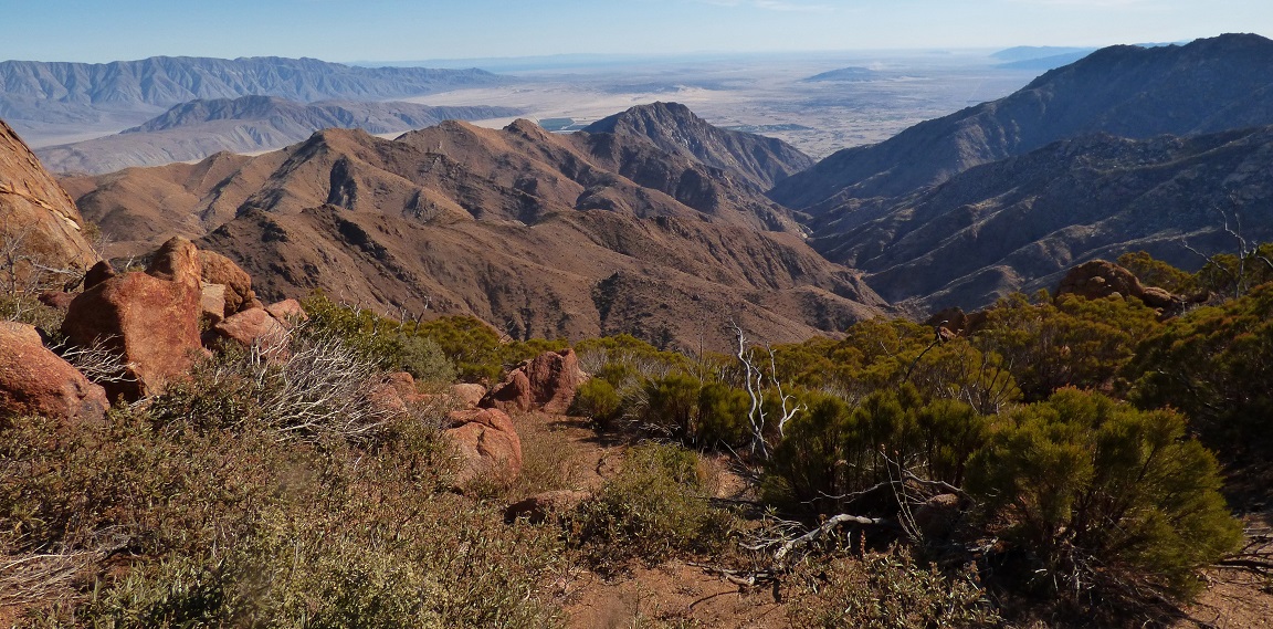
Sometime around 4:15am I found myself stumbling up a trail heading west from the parking lot (830 ft). It was pitch dark, with the moon having set several hours ago. I remained on the trail for 0.4 miles to the toe of Indianhead's southeast ridge, then took off up the ridge on rocky class 2 terrain. Even in pitch black, it was not hard to stay on the ridge as it was fairly well defined. All I really had to watch out for were the numerous little balls of cholla cactus. The lights of Borrego Springs shimmered below to the east, resembling a lit grid system as I ascended higher. Starting at ~2,850 ft, the ridge narrowed and became covered with several large boulders- many of them 20 ft tall. Some fun class 3 scrambling was required to get up and over these boulders. Around 6am, the eastern horizon beginning to glow, and as I reached the eastern subpeak before Indianhead, I switched off the headlamp. From the subpeak, it was an easy class 1-2 walk to the summit. I sat down on the summit for 20 minutes waiting for the sun to rise, perusing through the register which was a jumble of torn scraps.
sunrise from Indianhead
sunrise from Indianhead


After getting my fill of sunrise, I continued northwest along the class 2 ridge to The Knob.

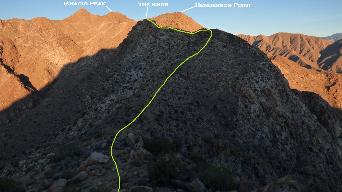
The next peak after The Knob, Henderson Point, did not look like anything special, nor was it topographically prominent at all, but it had been noted by several other peakbaggers as a point of interest. Since it lay at the tip of a "ridge peninsula," I guessed that this was due to its views, and sure enough, it was. I was also surprised to find a McLeod register from 1981.

views from Henderson Point
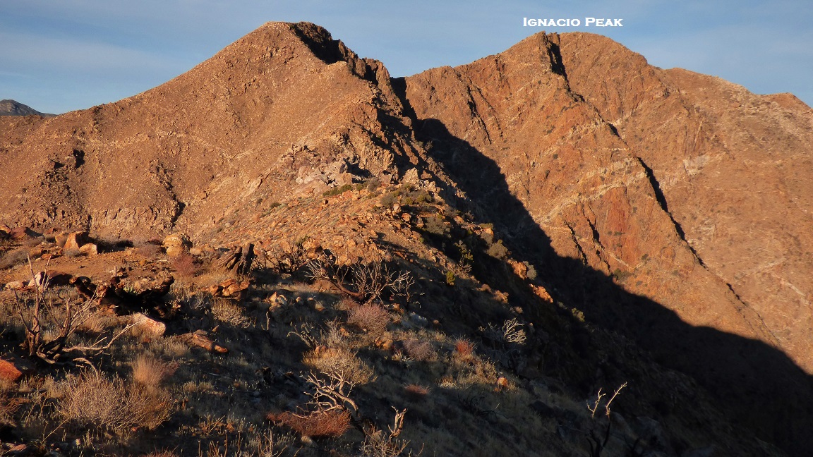
Getting from Henderson Point to Ignacio Peak was also straightforward ridge walking, going up and over one false summit before Ignacio.


views from Ignacio Peak


between Ignacio Peak and Palm Mesa High Point

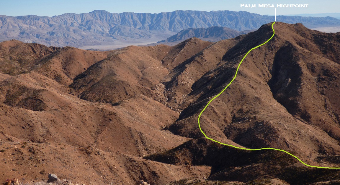
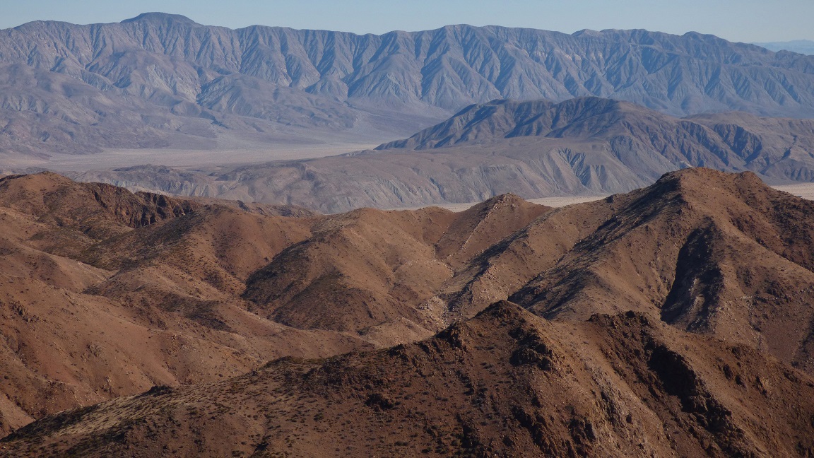
Palm Mesa High Point marked my entry point onto Palm Mesa, a ~2.5 square mile elevated area bordered by Palm Mesa High Point, Cody Benchmark, Pike Benchmark, and Bennis Peak. The mesa was comprised of a series of large rolling hills and not one single palm tree.
views from Palm Mesa High Point


register

From here, I dropped down the west ridge of Palm Mesa Highpoint and ascended the northeast ridge of Fork Division Peak, which divided the North and Middle forks of Borrego Palm Canyon. Both ridges were mostly class 1 and contained surprisingly no bushwhacking.
views from Fork Division Peak

From Fork Division Peak, I made a beeline up Cody Benchmark's northeast slope, ascending about 1,000 ft. There were a multitude of ways to ascend, and the bushwhacking was very light as long as I stayed out of the gullies.

Upon reaching Cody Benchmark at 10:30am, I plopped down and snaked on some crackers while scanning the surrounding peaks.
views from Cody Benchmark


register/benchmark

A short distance to the west lay two obvious granite bumps which were Norte and Phil benchmarks. Getting to them involved some easy rock hopping and some small ups and downs on the ridge. Both benchmarks contained registers, but only Norte contained an actual benchmark.
Norte Benchmark


view north from Norte

view northeast from Phil Benchmark

Phil Benchmark register

looking south from Phil

From Phil Benchmark, I continued north to intersect the east-west-running ridge connecting Dry Benchmark and Pike Benchmark. After a series of ups and downs, I reached Dry Benchmark to find a register but no benchmark.

view from Dry Benchmark

Army Benchmark was located along the ridge roughly halfway between Dry Benchmark and Pike Summit, containing no topographic prominence. I did not find a benchmark, but managed to locate several stakes and survey wire where the benchmark should've been found.
view from Army Benchmark (note strange smoke pillar to the south)

The scramble up to Pike Summit was a short and fun rock hop.

register on Pike Summit

views from Pike Summit

A very short distance to the east of Pike Summit was Pike Benchmark, which contained a more expansive view of Palm Mesa.


After dropping a little under 1,000 ft of elevation down Pike Summit's east side, I intersected the west ridge of Deering Peak. I remember talking to someone who noted that this peak was worth the visiting, though I didn't find it too interesting.
last bit to Deering Peak

views from Deering Peak

I descended Deering's broad class 1 northeast ridge, then intersected a prominent wash which I followed northeast up to the summit of Bennis Peak. Bennis marked the northeastern tip of Palm Mesa. It was already 2:30pm and going to get dark in two hours, so I ate quick snack, glanced at the map, took one last gaze across Palm Mesa, and plunged northeast down the main ridge towards Galleta Point, the last peak on the traverse.
views from Bennis Peak


heading towards Galleta Point


I reached Galleta Point at 3:20pm, surprisingly finding a register.


Now it was time for the big drop. I would descend the main ridge southeast for a few miles to where it finally plopped into Galleta Meadows at ~1,070 ft. As I descended, the amount of cholla and agave increased as expected, but they were not as abundant as I had initially predicted. Down, down, down I went. The sunlight slowly crept eastward across Borrego Springs as the sun dropped behind the San Ysidro Mountains, and before long only the Santa Rosa Mountains were lit. As the shadow of the San Ysidros slowly crept up to the Santa Rosa Crest, it became increasingly vivid in the familiar hues of desert alpenglow, eventually vanishing completely.


dropping into Galleta Meadows

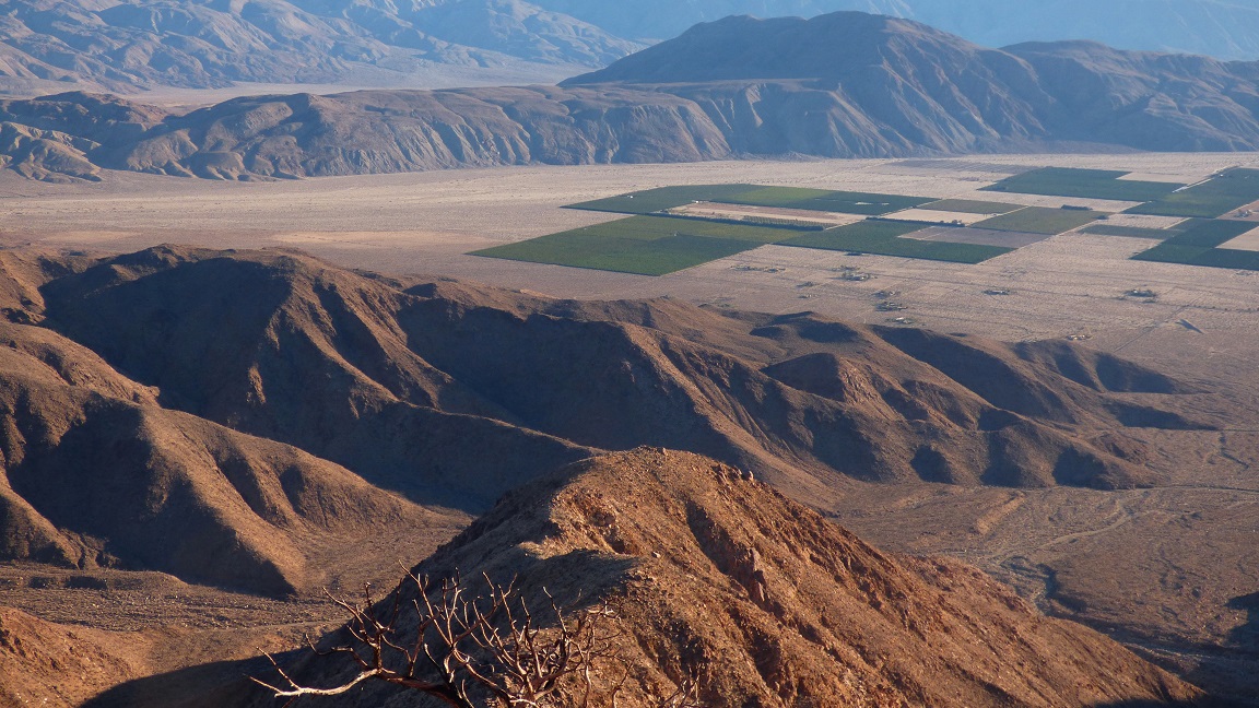
It was around 5pm as I finally dropped into Galleta Meadows, which was characterized by the usual desert floor dotted with light shrubs and broad sandy washes. There were now 4.2 miles of desert floor remaining between me and the trailhead. Navigation was easy enough, as all I had to do was walk around the eastern side of Indianhead. About two thirds of the way back to the trailhead, I came upon a private residential area bordered by a golf course. There was no way around it as it came right up to the base of Indianhead (unless I wanted to do some sidehilling up Indianhead), so I switched off my headlamp and quietly walked through it, encountering no trouble. Shortly after crossing the golf residential area, I was back on the barren desert floor and could spot a few lights to the southwest that had to be the campground. I made a beeline for it, arriving back at around 6:20pm.
Weather Forecasts
trailhead
east side of traverse
west side of traverse
Peakbagger Pages
Indianhead
The Knob
Henderson Point
Ignacio Peak
Palm Mesa High Point
Fork Division Peak
Cody Benchmark
Norte Benchmark
Phil Benchmark
Dry Benchmark
Army Benchmark
Pike Summit
Pike Benchmark
Deering Peak
Bennis Peak
Galleta Point
Summitpost Pages
Indianhead
Standing Ovation! That is an insanely long cross country traverse over some unforgiving terrain. I've bagged Indianhead and Ysidro but still have a lot of peaks left to do in the area. This report will help. Thanks for sharing.
ReplyDelete