
October 3, 2015
Falls Ridge (see map) is a fairly nondescript feature located between Cathedral Creek and the Grand Canyon Of The Tuolumne River in Yosemite. Due to its low stature among all the surrounding 10,000 ft peaks, it is mostly ignored. Mason, Sean, and I had initially planned to ascend the nearby 2-day Colby Traverse, but with nasty weather forecasted for Sunday, that plan was scrapped. Mason suggested Falls Ridge, a feature he had read about in one of Bob Burd's reports which Sean and I had never heard about. I headed into the weekend thinking that this would be a relatively insignificant ridge walk. Little did I realize that this would be one of the most unique and scenic Sierra ridge traverses I had ever done, especially for one that could be done in a day.
| Peak | Elevation | Topographic Prominence | Summit Coordinates (lat/lon) |
|---|---|---|---|
| Falls Ridge East | 9,134 ft | 1,034 ft | 37.9051, -119.4345 |
| "McGee Dome" | 9,003 ft | 128 ft | 37.9085, -119.4386 |
| "Scary Dome" | 8,807 ft | 90 ft | 37.9103, -119.4411 |
| "Scar Dome" | 8,868 ft | 186 ft | 37.9103, -119.4470 |
| SAR Dome | 8,829 ft | 249 ft | 37.9103, -119.4579 |
| Falls Ridge West | 8,620 ft | 560 ft | 37.9161, -119.4695 |
| "Grand Light Dome" | 8,580 ft | 280 ft | 37.9240, -119.4794 |
| "V-Tree Dome" | 8,395 ft | 165 ft | 37.9277, -119.4889 |
Getting to the trailhead: The trailhead is a large pullout on the northern side of SR120, immediately south of Pothole Dome.
Trailhead coordinates (lat/lon): 37.8768, -119.3942
The temperature was hovering at around 20 degrees as the three of us started off at around sunrise, taking a well worn trail to the north side of Pothole Dome. The brown grass of Tuolumne Meadows was sagging under a think layer of frost, and steam was rising from a few stagnant water sources on the edges of the meadow. The first big winter storms were definitely not far off, and we were glad to have this window of opportunity on this fine day.
At the north side of Pothole Dome, the well worn trail quickly petered out and was replaced by a faint use-trail which continued along the southern side of the Tuolumne River. Less than a mile later, that trail dissipated too, and we continued northwest, following the Tuolumne River on some easy cross country terrain and remaining on the river's southern side.
Cathedral Peak shortly after sunrise

Tuolumne River

After around 2 miles of cross country, we intersected the PCT at an impossible-to-miss footbridge.

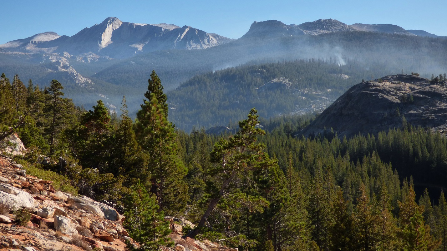
The PCT continued following the Tuolumne River downstream for a mile, eventually reaching a junction at the eastern toe of Falls Ridge. Somewhere off to the east, there were small fires smoldering in the forest. We initially thought it was fog, but eventually were able to smell it. Whatever it was, it seemed likely that it was under control, with the smoke being within so many lines of sight from SR120.

From the trail junction, we turned left (southwest) for just under a mile and continued to McGee Lake, where we filled up on water. A few hundred feet after the lake, we left the trail and began ascending the southwest ridge of Falls Ridge East. This was a fun little ridge, consisting of mostly blocky scrambling with a few easy class 3 sections.
McGee Lake

ascending Falls Ridge East


From the summit of Falls Ridge East, most of the remaining traverse was laid out in front of us to the west. It looked like it was only a hop, skip, and a jump to get to the other side of the traverse, but the easy appearance was somewhat deceiving. It would take longer than we thought to reach the end of the ridge at V-Tree Dome, but it wasn't insanely difficult and would get increasingly scenic as we continued westward.
summit views from Falls Ridge East


looking WNW

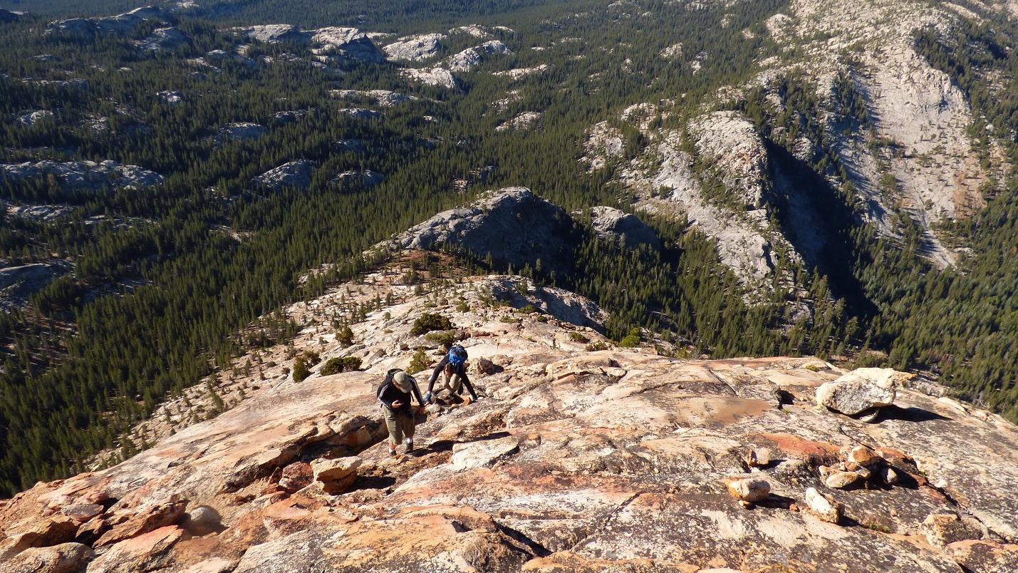
We continued westward along the main ridge, climbing up and over three intermittent domes before reaching McGee Dome. The terrain, much like the terrain which would accompany us throughout the remaining traverse, consisted of large blocks interspersed with patches of mostly avoidable manzanita. If one searched hard enough, they may be able to find an entirely class 2 route through the jumble of boulders, but we were content and having much fun with the class 3 (and occasional class 4) moves. Throughout the first few domes, there were grand views north into the Grand Canyon of the Tuolumne River.


looking southeast from McGee Dome

Immediately after McGee Dome was a small dome which Mason dubbed "Scary Dome." It contained a fun class 4-5 crack system up its southern and southwestern sides. Its northwestern side was a simple walk off.

looking southeast from Scary Dome

northeast

west

Just west Scary Dome was a broad dome with some class 3 slabs on its eastern side. Immediately after that was Scar Dome, which contained a grippy class 4 crack on its eastern side. We had some fun scrambling all over that one.


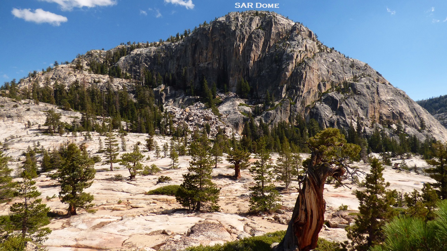
Next up was SAR Dome (etymology unknown). A gradual class 1-2 ramp ran up its eastern side, which was a nice little reprieve from all the blocky scrambling we had done so far.


looking northwest from SAR Dome

The western side of SAR Dome was composed of a large wall and several large slabby cliffs. We were able to bypass these by first descending the north ridge to a prominent saddle, then descending a gradual ramp on the west side of SAR Dome, below the cliffs. After that was a 15 minute walk on a beautiful slabby plateau with a variety of cedar and pine scattered about, until we encountered a wall of manzanita just before Falls Ridge West. Despite its initial appearance, the manzanita was not too bad, and we found numerous breaks in the brush.


Every route up Falls Ridge West's east face was comprised of class 3 slabs and light bushwhacking.

summit views from Falls Ridge West


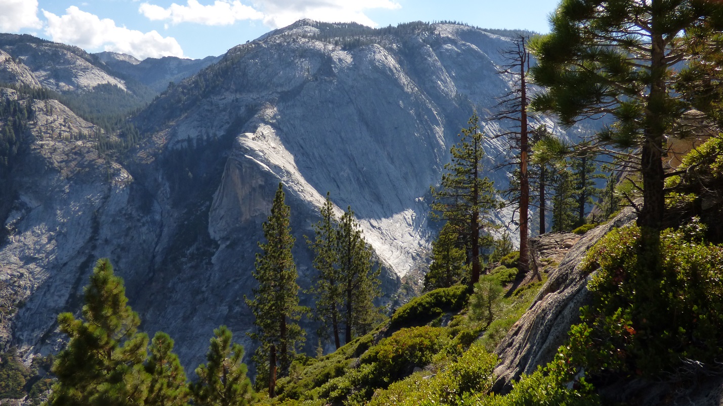
For the remaining ridge to V-Tree Dome, the views continued to get better as both sides of the ridge dropped away and narrowed, and the canyons on both sides got dramatically deeper. Terrain wise, it was much the same as it had been- mostly class 2, with some class 3 slabs and blocks. There were a few places where the rock was polished enough for us to sit and slide. Closer to V-Tree Dome, the bushwhacking increased slightly, but it only came in short spurts.


V-Tree Dome marked the western end of Falls Ridge, so naturally it contained an awesome view west to where The Grand Canyon of the Tuolumne River and Cathedral Creek Canyon joined. The summit block was a 15 ft class 5 boulder which we were able to surmount with the help of a tree growing on its south side. Mason and I ascended it by shimmying between the tree and boulder, treating it like a chimney. Sean decided to climb the tree first and try to scoot onto the boulder, which his legs flailing below the branches as he made the transition. We all agreed that with the aid tree, the summit block felt like class 5.4.


views from V-Tree Dome


After enjoying the grandeur of V-Tree Dome for 30 minutes, we saw that the sun was getting lower and it was time to head back. The plan was to retrace our steps to the north side of SAR Dome, and take a gradually lowering ramp northeast to a trail paralleling the Tuolumne River, intersecting it just west of California Falls.


Sunset came as we reached the slabby plateau west of SAR Dome. If we were backpacking, this would've been a perfect place to camp.


The ramp descended at a gradual angle. Most of it involved walking on soft ground under forested slopes. Eventually we caught sight of the trail on the other side of the Tuolumne River. Both sides of the river were lined with nicely polished slabs, and we walked over and easily crossed the river, which was at very low levels at this time of year. Upon reaching the trail, it was finally dark enough that we needed the headlamps. We followed the trail upstream for 1.8 miles before intersecting the JMT and retracing our approach route from earlier that morning, simply following the Tuolumne River upstream until we reached the well worn trail at Pothole Dome. Even in the pitch dark, navigation wasn't difficult as all we had to do was listen to the river to our left. Sometime around 9pm, we got back to the car, still feeling amazed by the views we had seen a few hours earlier.
Total Stats
21.2 miles
7,083 ft gain/loss

Weather Forecasts
entire route
Peakbagger Pages
Falls Ridge East
Scary Dome
Scar Dome (Note: Location is misplaced. Scar Dome is the next higher bump to the west of the indicated placement)
SAR Dome
Falls Ridge West
Grand Light Dome
V-Tree Dome
Other
Yosemite National Park
SR120 road conditions
Those are fantastic photos, hell of an area and great trip write-up!
ReplyDeleteAwesome photography, fascinating descriptions. Oh, to be young again, and with the 'tech' available today to share such travels!
ReplyDelete