
July 19-21, 2013
It was a hot and humid Friday afternoon in Owens Valley. A filmy haze settled over the valley, bits of smoke brought over from a large fire burning in the San Jacinto Mountains 200 miles south. Nine of us had managed to cram ourselves into a truck (6 in front, 3 in truck bed), heading west on a bumpy dirt road towards George Creek Trailhead. The plan was to hike up George Creek on Friday to a good campsite at 10,000 ft. The next morning, we would get up and climb Trojan Peak (13,947 ft) & Mt. Barnard (13,990 ft) and return to camp, then climb Mt. Williamson (14,373 ft) via Southeast Ridge on Sunday and hike out. I had read articles on George Creek describing it as "a classic Eastern Sierra bushwhack" that should not be taken lightly.
As the truck approached within 0.6 mi of George Creek Trailhead, we heard a loud pop and felt ourselves sink a little. A flat tire. After poking around for some time, we managed to find the spare and changed it. Some forty minutes later, looking at the deteriorating road ahead, we decided to park the truck there and walk the remaining 0.6 mi to the trailhead, finally departing at 5:20 pm. The road ended at a spot north of George Creek, which I assumed was the trailhead (6,320 ft). A small trail descended into an area shaded by oak trees, then vanished. Almost immediately, it seemed that we should cross to the south side of the creek as the north side started becoming bushy. This turned out to be a mistake. A few hundred feet after we crossed over, the terrain became even more chocked up with brush. We crossed back over to the north side, where a faint use trail wound along the creek.
brush on south side

The use trail continued along a bend, after which we crossed to the south side and met up with more use trails. These continued for a few more bends and eventually petered out. We remained on the south side, doing some light bushwhacking and hopping over fallen logs from time to time. Every so often it looked like a big rock or fallen tree would block our progress, but there was always a way around it. Mainly, we would try to stick as close as possible to the canyon wall when it looked impassable.

The real roadblock came at a waterfall, where big boulders completely blocked any advancement on the south side. One of the boulders leaned against the canyon wall, creating a nice watertight "cave" that could fit 2-3 backpackers comfortably for an overnight stay. We crossed to the north side at the base of the waterfall on some slippery rocks. Later while coming back, we found that there was an alternate crossing about 200 ft before the waterfall on a fallen log.

As soon as we were able to bypass the boulders that blocked off the south side, we crossed back over. We would stay on the south side for the remainder of the day. The canyon began opening up, and there was a lot of space for us to spread out. A thicket of pine trees surrounded us, many of them fallen and scattered throughout the area. When the thicket ended, a use trail took us up and contoured along a hillside, a few hundred feet above George Creek. The canyon was wide open now, and I could see two prominent peaks to the west. The use trail continued for about a quarter mile, then dropped back down to the creek. There was a possible crossing spot over to the north side, but we decided to stick south. A rock face jutted out from the south and we contoured along the base of it, avoiding patches of stinging nettle here and there. The rock face ended in a little under a quarter mile, and the canyon opened up again. There were some faint footprints in the dirt along with some occasional cairns. We ascended and contoured the canyon's south slopes, staying 100-250 ft above George Creek.
It was well after 8pm and getting dark. We continued contouring up on sandy slopes. Use trails flickered in and out of view here and there. A steep rise came into view way up the canyon. The 10,000 ft camp lay not far above it.
As it got dark, our progress because increasingly slower as it became harder to find a route through the ever increasing brush. A semi-full moon was rose up from the east, but steep canyon walls blocked off its light. There were no more use trails now, and we were constantly bushwhacking through shoulder high chaparral, consisting primarily of manzanita and buckthorn. It went on for hours. At one point, I was surprised to find us less than 50 ft above George Creek when we should've been higher. We climbed up, and the brush thinned out a little. A few people in the back were starting to tire out, and stops became more frequent. At 10pm, we were at 8,400 ft and making slow progress. I started scanning the surrounding hillside for good areas to camp, but saw none. At 10:30 pm, I noticed a thicket of trees further up the canyon and beckoned everyone towards it, anything to get away from all that thorny chaparral. To my surprise, a great use trail appeared. It seemed that we had been hiking below it the entire time.
After meandering through trees for about a quarter mile, the trail passed along a creek. This creek flowed from a side canyon to the south and would meet up with George Creek down north. Our group stopped there briefly for some water, and kept going. The trail did not cross the creek, but headed south, paralleling it. A few moments later the trail had disappeared. We spread out and searched, but found nothing. It was past 11pm, and we were only at 8,900 ft.
A few people started dropping their packs saying that they wished to camp there. I noticed two spots sufficient for two person tents. It was sloped everywhere else. Those spots were taken almost instantly by Fran, Tracey, and Tommey, leaving the rest of us to search around for more. I managed to locate a spot 50 ft above the other two and called over Sung, who I was tenting with. The area was a little small for the tent, but it worked. Mike and Philipe managed to find a spot a few hundered feet to the south. Chris and Patrick located one a few hundred feet north. I quickly set up my sleeping bag, wolfed down some fried chicken, and was fast asleep by 12am.
I awoke suddenly from a deep sleep on Saturday morning. Tommey had walked over to our tent to see that we were still asleep, came as close as possible, and yelled "Eric, Sung, get up!" I stumbled out of the tent, still a little dazed from the wake up call, to find it a beautiful day. Blue skies, chirping birds, and a steady flowing river right by camp. I took a look at the rise that had looked so steep the previous night. Now with our camp right below it, it looked like class 2 climbing at the most. I joined in with a group of four who were eating breakfast, discussing if they should climb Mt. Williamson that day instead of Trojan and Barnard. Mt. Williamson is the Sierra's 2nd highest mountain, and is far more widely known and sought out than is Trojan and Barnard. Half the group had Williamson on their priority list. Fran, who had planned out the trip, was adamant about sticking to the original plan of climbing Trojan and Barnard on Saturday because they were the hardest, then spend Sunday at a more relaxing pace climbing Williamson and hiking out.
Saturday morning at camp (8,900 ft)

I consulted the map, and to my surprise, we were camped directly at the fork of a side canyon that is often used to climb Mt. Carl Heller's East Ridge. Carl Heller was a peak that both Tommey and I had been wanting to climb for a long time. Based on trip reports, the East Ridge contained solid class 4 climbing on excellent rock. After a few short moments, the two of us decided to go for Carl Heller, then traverse over and meet up with the rest of Fran's group later in the day, somewhere between Barnard and Trojan. Fran handed us a radio, which we planned to turn on at 12pm to update eachother on our locations.
Tommey and I were on our way up the side canyon by 6:35 am. From camp, we crossed to the west side of the creek (which I will refer to as "Heller Creek") and paralleled it upward. After a few minutes, the terrain started to cliff out. We crossed back to the east side with a little bushwhacking in the process.

The terrain opened up as we followed Heller Creek upstream on its east side. Easy boulder hopping.

looking downstream

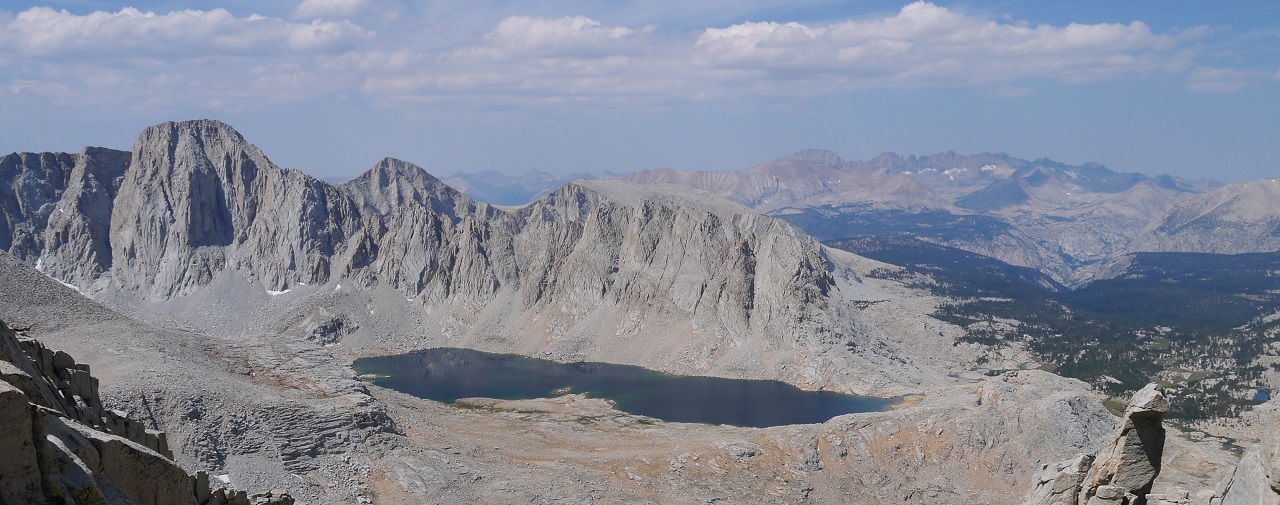
The terrain flattened out briefly and a rock field appeared ahead. Up and over this rock field was a lake at 11,200 ft (which I will refer to as "Heller Lake"). Heller Creek terminated at the outlet of Heller lake. This lake would be our last water source until Wallace Lake on the other side of Mt. Carl Heller.

Heller lake and Mt. Carl Heller


We contoured around the east side of Heller Lake, heading south. Upon reaching some big slabs, we contoured to the south of them before finding a way to get onto them. Following the slabs upward to the southwest soon put us at the base of Mt. Carl Heller's East Ridge.

looking back at Heller Lake from slabs


Upon reaching the base of the East Ridge, we noticed a series of cracks and ledges that ran up its south side. They consisted of class 3-4 climbing on very solid and enjoyable rock.

Once at a notch on the ridge itself, a traverse around a short exposed class 3 ledge on the north side brought us to a class 2 "boardwalk" of slabs.


The boardwalk slabs ended after a few hundered feet, forcing us to drop down slightly to the north side, traversing across a slanted slab with good cracks. As soon as the slab ended, we were able to get back onto the main ridge.

Tommey climbing slanted slab


We continued up on the ridge, passing a rhombus-shaped rock, then onto a leaning slab. Further up from the leaning slab lay a cracked slab with what looked like class 5 climbing. Dropping down to the north wasn't an option as that side of the ridge went straight down. The only option was to drop south, but I couldn't see what was below me. I lowered myself down onto a precarious foothold, and saw the drop down south via a class 4 crack. Cautiously lowering myself onto more holds, I found that the crack lasted for only about 15 ft before ending at some class 3 ledges.


leaning slab


We dropped down about 40 more feet to meet a class 3 ramp, which gradually angled up, contouring the south side of the ridge. After 100 ft on this ramp, a easy class 4 crack with good holds led us back onto the ridge.

Upon gaining the ridge, we dropped down north when it became impassable again. A series of exposed class 3 ledges led to the base of a chute between Carl Heller and a false summit.

The chute turned out to be class 3 and slightly sandy in sections. It ended at a notch slightly north of Carl Heller. There was a great view towards the west from this notch.

From the notch, we headed left (south) to scramble up a few big blocks to the summit (13,225 ft). The biggest challenge was a class 4 crack immediately south and up from the notch. We topped out on Carl Heller's summit at 11am. The East Ridge had been a truly magnificent and enjoyable climb.
summit views


A broad class 2-3 descent gully ran off to the southwest of Mt. Carl Heller towards Wallace Lake. We made the mistake of descending too far to the north, where a series of class 5 slabs and ledges blocked our progress downward. We doubled back south, where a class 2 gully bypassed the ledges, spilling us out at the south side of Wallace Lake. At 12pm, we turned on our radio and called Fran, but no one answered.


We took a short break at Wallace Lake (11,450 ft), chomping on energy bars and filling up on water. Tommey took a dip in the lake, lasting less than a minute in cold water. Several class 2 gullies headed up northeast from Wallace lake onto a plateau (which I will refer to as "Plateau Point"). This plateau continued north, terminating at Barnard East.
The class 2 gullies turned out semi-loose, composed of talus and sand. The last 300 ft of it was filled with loose scree, prompting us to take some class 3 ribs that separated the gullies for more enjoyable climbing.

view of Wallace Lake from Plateau Point (12,500 ft)

From Plateau Point, it was a easy class 1-2 walk up to Barnard East. The first half of it consisted of walking on gentle sandy slopes, which became increasingly rocky as we got higher. What looked like the highpoint from Plateau Point turned out to be a false summit, which we accidentally ascended to. The true summit lay to the north of the false summit.


true summit viewed from false summit


Barnard East's summit (13,714 ft) contained fine views, especially southwest towards Mt. Young, Mt. Hale, and Wales Lake. We reached the summit just before 3pm. There was a small register present, but it lacked a writing utensil.


Mt. Barnard lay a short distance to the west of East Barnard. We descended East Barnard's loose talus north slopes to a flat area below some permanent snowfields. Little trickles of water flowed from these snowfields, which were melting out fast. From there, Mt. Barnard (13,990 ft) was a easy class 2 climb via its East Face.

The ascent up Mt. Barnard's East Face was uneventful and on relatively solid terrain. Because of improving light, the views were becoming considerably better. I noticed a few storm clouds to the north, but they were too far away to cause any concern. I checked the register to see if anyone else in our group had been up there that day. Seeing none, we reasoned that they had headed for Williamson instead. They were probably already back at camp eating dinner, discussing the route for Trojan and Barnard on Sunday.


Tyndall West & Mt. Tyndall

It was 4:50 pm as we started descending Mt. Barnard, heading towards our last peak: Trojan Peak. The climb up this peak was uneventful- a class 2 talus slog. Just one foot in front of the other.

Upon reaching Trojan's summit just before 7pm, I was amazed at the view north. The entire Williamson Bowl spread out in front of us, flanked by Mt. Tyndall to the west and Mt. Williamson to the east. I opened the register box, brushed aside a few condoms (of course), and signed the book quickly before digging out my camera and snapping away. There was amazing lighting in all directions, especially towards the west where an opening in the clouds resulted in rays of sunlight being cast on the Kaweahs.


We were amazed by the views, and didn't leave the summit until 7:35 pm. There was a 5,000 ft descent back to camp waiting for us. We descended into the bowl that separated East Barnard, Barnard, and Trojan, and headed east as the sides of the bowl caved inward, dropped down, and became a canyon.

The initial dropoff below the main bowl dropped us into a smaller bowl containing a lake at 10,900 ft. Everything between Trojan Peak and this lake had been soft and sandy, allowing us to coast down the slopes by heel plunging- a very nice descent. It had taken us about 45 minutes to descend almost 3,000 ft. The terrain below Lake 10,900 ft became rockier, and our pace slowed. It became dark, and headlamps clicked on. Our plan was to follow the canyon until it spilled out into the main canyon containing George Creek, then descend back to camp along the south side of that canyon.
As we intersected the main George Creek canyon at 8:45 pm, I looked up at a prominent ridgeline to the north and thought I caught a glimpse of a light on the south side of it (the side directly facing us). I blinked, and looked again. Yes, there certainly was a light. I pointed this out to Tommey as more lights appeared. There seemed to be two lights on the south side, and one way up top. The thought suddenly hit us that this was probably our group. Tommey dug out the radio as both of us shouted as loud as we could: "FRAN, TURN ON YOUR RADIO!" After about 5 minutes of this, we heard Fran's voice on the radio. He said that they had summited Williamson earlier that day, descended as it got dark, and descended too far to a wrong chute. Not wanting to climb back up, everyone had gone down that chute anyway. Fran and Philipe were at the tail end of the group, and they were the single light we saw at top of the ridge. Fran said that one of their lights went out, and they were stuck at the top of the chute. It was dangerous to descend what looked like class 3 terrain with only one light between two people, so they had decided to find a comfortable looking spot and spend the night on the ridge, descending at first light. They had decided to do this only moments before, so everyone below them did not know it. Everyone else was either descending on the south side of the ridge, or somewhere in George Creek canyon descending back to camp.
8:45 pm

After talking to Fran on the radio for about 15 minutes, we wished him and Philipe a safe night, and resumed our descent back to camp about 2,000 ft below. After a few moments, we saw that the two lights descending the ridge were making good progress, and decided to wait for them to catch up. As the lights descended into George Creek canyon, trees blocked them off from view. I managed to hear a faint voice of a girl, so one or both of them had to be Sung or Tracey.
We sat there, expecting lights to pop up at any moment. Clouds started moving in from the north, covering up an almost-full moon. Nearly an hour passed. More clouds. Still no lights. We finally reasoned that the two people descending (which we now referred to as "the girls") had seen the single light above them, and were waiting for them to descend. But that light belonged to Fran and Philipe, who were not descending. We figured that the girls would eventually get tired of waiting, and resume their descent to camp. The sky was completely filled with clouds now, clouds that were becoming thicker. As a few drops of rain hit us, we decided, "screw this, lets go," and resumed our descent at 10:15 pm, about 1,200 ft above camp.
The descent was nice and gentle, weaving between trees. There was almost no bushwhacking as we were high above George Creek. Some light rain fell here and there in brief showers. We suddenly came to a dropoff 400 ft above camp. The grove of trees that surrounded camp was visible below us. A series of ledges and cliff outs appeared below us. We cautiously scooted down these ledges, which were class 3. I knew that there was an easier way around them, but this would do. The ledges descended about 200 ft, and then it was a walk on a gradual slope back down to camp. We crossed Heller Creek, and came to Mike and Philipe's tent. Mike was inside, seeming to have gotten back to camp a while ago. It was just after 11pm.
Tommey and I hiked the short distance back to our tents to find Tracey in her tent. It seemed that she had been waiting there for a while and was excited to see us, speaking enthusiastically and asking us about our climb. When we asked Tracey about her climb, she said that she and Mike turned back at 12,000 ft at 4pm after realizing that they would not make it back to camp before dark if they kept on proceeding to Williamson's summit. The rest of the group had been ahead of them, so Tracey and Mike had been the first ones back to camp before Tommey and I showed up. Tracey did not seem all that surprised when we told her what had happened.
Over the next hour and a half, Tommey and I ate dinner and chatted with Tracey about other things. I gulped down two cups of noodles, which tasted really good after a long climb. Clouds parted, and a bright moon lit up the night sky. I periodically looked up the canyon to see if any lights were descending.
Sometime after midnight, two lights caught my eye. They were descending on the ledges above camp. I headed over to Tommey and asked for his headlamp (which was much brighter that mine) and rushed over to the other side of Heller Creek, leaving Tommey and Tracey still immersed in conversation. I got to an area where I could clearly make out the lights, and waved the headlamp back and forth, hoping to catch their attention. After about a minute, they saw the light and began heading towards me. As the lights got closer, I saw that there were actually three. One of them had been too dim to see from afar. The lights belonged to Sung, Chris, and Patrick. Chris reached me first, worriedly asking about Fran and Philipe's whereabouts. As the remaining two caught up, I briefly told them what had happened, and we headed back to camp.
Back at camp, the three of them filled us in on the full story. A total of five had summited Williamson via Southeast Ridge by 5pm. They headed down in a hurry, knowing that they were going to get back to camp after dark. Their sketchiest moment was descending a class 3 scree chute in pitch dark. Sung had slipped on some scree, went into a back flip, and landed face down on the slope. She got back up, and the three of them continued down. Upon reaching George Creek canyon, they had waited a while for Fran and Philipe, who were supposed to be descending behind them, but were nowhere to be seen. Their single light at the top of the ridge was not visible from the position the three of them were at. They eventually continued their descent when it started raining, thinking that Fran and Philipe had passed them somewhere along the way without them knowing it. A few hours later, they had arrived back at camp.
There were now seven of us back at camp and two on Williamson's Southeast Ridge. We chatted for a little while, then proceeded to our tents. I crawled into my sleeping bag and was asleep within minutes. Overhead, the sky was completely clear of clouds.
I woke up the next morning to hear people taking. Climbing out of the tent, I was surprised to see Fran already back at camp eating breakfast. It turned out that him and Philipe had started descending at around 10pm when it started raining, inching their way down the chute with one light, reaching camp sometime after 3am.
Everyone was in a light mood. We joked around about the previous day's events as we ate breakfast. Having decided to hike out that day, everyone sat around camp relaxing for a few hours. We packed up, and started descending by late morning. This time, our route stayed high up on the south side of George Creek, bypassing all the bushwhacking that had slowed us down on the way up. There was a nice use trail for most of the way back, with some small sections of bushwhacking here and there. We didn't descend to George Creek until a small cliff blocked progress, then it was back to some light bushwhacking. Four of us reached the waterfall an hour before the rest of the group did, and we enjoyed a dip in a small pool below it. After that, it was the usual river crossings and light bushwhacking back to the trailhead. Everyone made it back to the trailhead excited of what they had just accomplished, then piled into the truck and headed down into Lone Pine for a bite to eat.


As the truck approached within 0.6 mi of George Creek Trailhead, we heard a loud pop and felt ourselves sink a little. A flat tire. After poking around for some time, we managed to find the spare and changed it. Some forty minutes later, looking at the deteriorating road ahead, we decided to park the truck there and walk the remaining 0.6 mi to the trailhead, finally departing at 5:20 pm. The road ended at a spot north of George Creek, which I assumed was the trailhead (6,320 ft). A small trail descended into an area shaded by oak trees, then vanished. Almost immediately, it seemed that we should cross to the south side of the creek as the north side started becoming bushy. This turned out to be a mistake. A few hundred feet after we crossed over, the terrain became even more chocked up with brush. We crossed back over to the north side, where a faint use trail wound along the creek.
brush on south side


The real roadblock came at a waterfall, where big boulders completely blocked any advancement on the south side. One of the boulders leaned against the canyon wall, creating a nice watertight "cave" that could fit 2-3 backpackers comfortably for an overnight stay. We crossed to the north side at the base of the waterfall on some slippery rocks. Later while coming back, we found that there was an alternate crossing about 200 ft before the waterfall on a fallen log.

As soon as we were able to bypass the boulders that blocked off the south side, we crossed back over. We would stay on the south side for the remainder of the day. The canyon began opening up, and there was a lot of space for us to spread out. A thicket of pine trees surrounded us, many of them fallen and scattered throughout the area. When the thicket ended, a use trail took us up and contoured along a hillside, a few hundred feet above George Creek. The canyon was wide open now, and I could see two prominent peaks to the west. The use trail continued for about a quarter mile, then dropped back down to the creek. There was a possible crossing spot over to the north side, but we decided to stick south. A rock face jutted out from the south and we contoured along the base of it, avoiding patches of stinging nettle here and there. The rock face ended in a little under a quarter mile, and the canyon opened up again. There were some faint footprints in the dirt along with some occasional cairns. We ascended and contoured the canyon's south slopes, staying 100-250 ft above George Creek.
It was well after 8pm and getting dark. We continued contouring up on sandy slopes. Use trails flickered in and out of view here and there. A steep rise came into view way up the canyon. The 10,000 ft camp lay not far above it.
As it got dark, our progress because increasingly slower as it became harder to find a route through the ever increasing brush. A semi-full moon was rose up from the east, but steep canyon walls blocked off its light. There were no more use trails now, and we were constantly bushwhacking through shoulder high chaparral, consisting primarily of manzanita and buckthorn. It went on for hours. At one point, I was surprised to find us less than 50 ft above George Creek when we should've been higher. We climbed up, and the brush thinned out a little. A few people in the back were starting to tire out, and stops became more frequent. At 10pm, we were at 8,400 ft and making slow progress. I started scanning the surrounding hillside for good areas to camp, but saw none. At 10:30 pm, I noticed a thicket of trees further up the canyon and beckoned everyone towards it, anything to get away from all that thorny chaparral. To my surprise, a great use trail appeared. It seemed that we had been hiking below it the entire time.
After meandering through trees for about a quarter mile, the trail passed along a creek. This creek flowed from a side canyon to the south and would meet up with George Creek down north. Our group stopped there briefly for some water, and kept going. The trail did not cross the creek, but headed south, paralleling it. A few moments later the trail had disappeared. We spread out and searched, but found nothing. It was past 11pm, and we were only at 8,900 ft.
A few people started dropping their packs saying that they wished to camp there. I noticed two spots sufficient for two person tents. It was sloped everywhere else. Those spots were taken almost instantly by Fran, Tracey, and Tommey, leaving the rest of us to search around for more. I managed to locate a spot 50 ft above the other two and called over Sung, who I was tenting with. The area was a little small for the tent, but it worked. Mike and Philipe managed to find a spot a few hundered feet to the south. Chris and Patrick located one a few hundred feet north. I quickly set up my sleeping bag, wolfed down some fried chicken, and was fast asleep by 12am.
I awoke suddenly from a deep sleep on Saturday morning. Tommey had walked over to our tent to see that we were still asleep, came as close as possible, and yelled "Eric, Sung, get up!" I stumbled out of the tent, still a little dazed from the wake up call, to find it a beautiful day. Blue skies, chirping birds, and a steady flowing river right by camp. I took a look at the rise that had looked so steep the previous night. Now with our camp right below it, it looked like class 2 climbing at the most. I joined in with a group of four who were eating breakfast, discussing if they should climb Mt. Williamson that day instead of Trojan and Barnard. Mt. Williamson is the Sierra's 2nd highest mountain, and is far more widely known and sought out than is Trojan and Barnard. Half the group had Williamson on their priority list. Fran, who had planned out the trip, was adamant about sticking to the original plan of climbing Trojan and Barnard on Saturday because they were the hardest, then spend Sunday at a more relaxing pace climbing Williamson and hiking out.
Saturday morning at camp (8,900 ft)

I consulted the map, and to my surprise, we were camped directly at the fork of a side canyon that is often used to climb Mt. Carl Heller's East Ridge. Carl Heller was a peak that both Tommey and I had been wanting to climb for a long time. Based on trip reports, the East Ridge contained solid class 4 climbing on excellent rock. After a few short moments, the two of us decided to go for Carl Heller, then traverse over and meet up with the rest of Fran's group later in the day, somewhere between Barnard and Trojan. Fran handed us a radio, which we planned to turn on at 12pm to update eachother on our locations.
Tommey and I were on our way up the side canyon by 6:35 am. From camp, we crossed to the west side of the creek (which I will refer to as "Heller Creek") and paralleled it upward. After a few minutes, the terrain started to cliff out. We crossed back to the east side with a little bushwhacking in the process.

The terrain opened up as we followed Heller Creek upstream on its east side. Easy boulder hopping.

looking downstream

The terrain flattened out briefly and a rock field appeared ahead. Up and over this rock field was a lake at 11,200 ft (which I will refer to as "Heller Lake"). Heller Creek terminated at the outlet of Heller lake. This lake would be our last water source until Wallace Lake on the other side of Mt. Carl Heller.

Heller lake and Mt. Carl Heller


We contoured around the east side of Heller Lake, heading south. Upon reaching some big slabs, we contoured to the south of them before finding a way to get onto them. Following the slabs upward to the southwest soon put us at the base of Mt. Carl Heller's East Ridge.

looking back at Heller Lake from slabs


Upon reaching the base of the East Ridge, we noticed a series of cracks and ledges that ran up its south side. They consisted of class 3-4 climbing on very solid and enjoyable rock.

Once at a notch on the ridge itself, a traverse around a short exposed class 3 ledge on the north side brought us to a class 2 "boardwalk" of slabs.


The boardwalk slabs ended after a few hundered feet, forcing us to drop down slightly to the north side, traversing across a slanted slab with good cracks. As soon as the slab ended, we were able to get back onto the main ridge.

Tommey climbing slanted slab


We continued up on the ridge, passing a rhombus-shaped rock, then onto a leaning slab. Further up from the leaning slab lay a cracked slab with what looked like class 5 climbing. Dropping down to the north wasn't an option as that side of the ridge went straight down. The only option was to drop south, but I couldn't see what was below me. I lowered myself down onto a precarious foothold, and saw the drop down south via a class 4 crack. Cautiously lowering myself onto more holds, I found that the crack lasted for only about 15 ft before ending at some class 3 ledges.


leaning slab


We dropped down about 40 more feet to meet a class 3 ramp, which gradually angled up, contouring the south side of the ridge. After 100 ft on this ramp, a easy class 4 crack with good holds led us back onto the ridge.

Upon gaining the ridge, we dropped down north when it became impassable again. A series of exposed class 3 ledges led to the base of a chute between Carl Heller and a false summit.

The chute turned out to be class 3 and slightly sandy in sections. It ended at a notch slightly north of Carl Heller. There was a great view towards the west from this notch.
From the notch, we headed left (south) to scramble up a few big blocks to the summit (13,225 ft). The biggest challenge was a class 4 crack immediately south and up from the notch. We topped out on Carl Heller's summit at 11am. The East Ridge had been a truly magnificent and enjoyable climb.
summit views


A broad class 2-3 descent gully ran off to the southwest of Mt. Carl Heller towards Wallace Lake. We made the mistake of descending too far to the north, where a series of class 5 slabs and ledges blocked our progress downward. We doubled back south, where a class 2 gully bypassed the ledges, spilling us out at the south side of Wallace Lake. At 12pm, we turned on our radio and called Fran, but no one answered.


We took a short break at Wallace Lake (11,450 ft), chomping on energy bars and filling up on water. Tommey took a dip in the lake, lasting less than a minute in cold water. Several class 2 gullies headed up northeast from Wallace lake onto a plateau (which I will refer to as "Plateau Point"). This plateau continued north, terminating at Barnard East.
The class 2 gullies turned out semi-loose, composed of talus and sand. The last 300 ft of it was filled with loose scree, prompting us to take some class 3 ribs that separated the gullies for more enjoyable climbing.

view of Wallace Lake from Plateau Point (12,500 ft)

From Plateau Point, it was a easy class 1-2 walk up to Barnard East. The first half of it consisted of walking on gentle sandy slopes, which became increasingly rocky as we got higher. What looked like the highpoint from Plateau Point turned out to be a false summit, which we accidentally ascended to. The true summit lay to the north of the false summit.


true summit viewed from false summit


Barnard East's summit (13,714 ft) contained fine views, especially southwest towards Mt. Young, Mt. Hale, and Wales Lake. We reached the summit just before 3pm. There was a small register present, but it lacked a writing utensil.


Mt. Barnard lay a short distance to the west of East Barnard. We descended East Barnard's loose talus north slopes to a flat area below some permanent snowfields. Little trickles of water flowed from these snowfields, which were melting out fast. From there, Mt. Barnard (13,990 ft) was a easy class 2 climb via its East Face.

The ascent up Mt. Barnard's East Face was uneventful and on relatively solid terrain. Because of improving light, the views were becoming considerably better. I noticed a few storm clouds to the north, but they were too far away to cause any concern. I checked the register to see if anyone else in our group had been up there that day. Seeing none, we reasoned that they had headed for Williamson instead. They were probably already back at camp eating dinner, discussing the route for Trojan and Barnard on Sunday.


Tyndall West & Mt. Tyndall

It was 4:50 pm as we started descending Mt. Barnard, heading towards our last peak: Trojan Peak. The climb up this peak was uneventful- a class 2 talus slog. Just one foot in front of the other.

Upon reaching Trojan's summit just before 7pm, I was amazed at the view north. The entire Williamson Bowl spread out in front of us, flanked by Mt. Tyndall to the west and Mt. Williamson to the east. I opened the register box, brushed aside a few condoms (of course), and signed the book quickly before digging out my camera and snapping away. There was amazing lighting in all directions, especially towards the west where an opening in the clouds resulted in rays of sunlight being cast on the Kaweahs.


We were amazed by the views, and didn't leave the summit until 7:35 pm. There was a 5,000 ft descent back to camp waiting for us. We descended into the bowl that separated East Barnard, Barnard, and Trojan, and headed east as the sides of the bowl caved inward, dropped down, and became a canyon.

The initial dropoff below the main bowl dropped us into a smaller bowl containing a lake at 10,900 ft. Everything between Trojan Peak and this lake had been soft and sandy, allowing us to coast down the slopes by heel plunging- a very nice descent. It had taken us about 45 minutes to descend almost 3,000 ft. The terrain below Lake 10,900 ft became rockier, and our pace slowed. It became dark, and headlamps clicked on. Our plan was to follow the canyon until it spilled out into the main canyon containing George Creek, then descend back to camp along the south side of that canyon.
As we intersected the main George Creek canyon at 8:45 pm, I looked up at a prominent ridgeline to the north and thought I caught a glimpse of a light on the south side of it (the side directly facing us). I blinked, and looked again. Yes, there certainly was a light. I pointed this out to Tommey as more lights appeared. There seemed to be two lights on the south side, and one way up top. The thought suddenly hit us that this was probably our group. Tommey dug out the radio as both of us shouted as loud as we could: "FRAN, TURN ON YOUR RADIO!" After about 5 minutes of this, we heard Fran's voice on the radio. He said that they had summited Williamson earlier that day, descended as it got dark, and descended too far to a wrong chute. Not wanting to climb back up, everyone had gone down that chute anyway. Fran and Philipe were at the tail end of the group, and they were the single light we saw at top of the ridge. Fran said that one of their lights went out, and they were stuck at the top of the chute. It was dangerous to descend what looked like class 3 terrain with only one light between two people, so they had decided to find a comfortable looking spot and spend the night on the ridge, descending at first light. They had decided to do this only moments before, so everyone below them did not know it. Everyone else was either descending on the south side of the ridge, or somewhere in George Creek canyon descending back to camp.
8:45 pm

After talking to Fran on the radio for about 15 minutes, we wished him and Philipe a safe night, and resumed our descent back to camp about 2,000 ft below. After a few moments, we saw that the two lights descending the ridge were making good progress, and decided to wait for them to catch up. As the lights descended into George Creek canyon, trees blocked them off from view. I managed to hear a faint voice of a girl, so one or both of them had to be Sung or Tracey.
We sat there, expecting lights to pop up at any moment. Clouds started moving in from the north, covering up an almost-full moon. Nearly an hour passed. More clouds. Still no lights. We finally reasoned that the two people descending (which we now referred to as "the girls") had seen the single light above them, and were waiting for them to descend. But that light belonged to Fran and Philipe, who were not descending. We figured that the girls would eventually get tired of waiting, and resume their descent to camp. The sky was completely filled with clouds now, clouds that were becoming thicker. As a few drops of rain hit us, we decided, "screw this, lets go," and resumed our descent at 10:15 pm, about 1,200 ft above camp.
The descent was nice and gentle, weaving between trees. There was almost no bushwhacking as we were high above George Creek. Some light rain fell here and there in brief showers. We suddenly came to a dropoff 400 ft above camp. The grove of trees that surrounded camp was visible below us. A series of ledges and cliff outs appeared below us. We cautiously scooted down these ledges, which were class 3. I knew that there was an easier way around them, but this would do. The ledges descended about 200 ft, and then it was a walk on a gradual slope back down to camp. We crossed Heller Creek, and came to Mike and Philipe's tent. Mike was inside, seeming to have gotten back to camp a while ago. It was just after 11pm.
Tommey and I hiked the short distance back to our tents to find Tracey in her tent. It seemed that she had been waiting there for a while and was excited to see us, speaking enthusiastically and asking us about our climb. When we asked Tracey about her climb, she said that she and Mike turned back at 12,000 ft at 4pm after realizing that they would not make it back to camp before dark if they kept on proceeding to Williamson's summit. The rest of the group had been ahead of them, so Tracey and Mike had been the first ones back to camp before Tommey and I showed up. Tracey did not seem all that surprised when we told her what had happened.
Over the next hour and a half, Tommey and I ate dinner and chatted with Tracey about other things. I gulped down two cups of noodles, which tasted really good after a long climb. Clouds parted, and a bright moon lit up the night sky. I periodically looked up the canyon to see if any lights were descending.
Sometime after midnight, two lights caught my eye. They were descending on the ledges above camp. I headed over to Tommey and asked for his headlamp (which was much brighter that mine) and rushed over to the other side of Heller Creek, leaving Tommey and Tracey still immersed in conversation. I got to an area where I could clearly make out the lights, and waved the headlamp back and forth, hoping to catch their attention. After about a minute, they saw the light and began heading towards me. As the lights got closer, I saw that there were actually three. One of them had been too dim to see from afar. The lights belonged to Sung, Chris, and Patrick. Chris reached me first, worriedly asking about Fran and Philipe's whereabouts. As the remaining two caught up, I briefly told them what had happened, and we headed back to camp.
Back at camp, the three of them filled us in on the full story. A total of five had summited Williamson via Southeast Ridge by 5pm. They headed down in a hurry, knowing that they were going to get back to camp after dark. Their sketchiest moment was descending a class 3 scree chute in pitch dark. Sung had slipped on some scree, went into a back flip, and landed face down on the slope. She got back up, and the three of them continued down. Upon reaching George Creek canyon, they had waited a while for Fran and Philipe, who were supposed to be descending behind them, but were nowhere to be seen. Their single light at the top of the ridge was not visible from the position the three of them were at. They eventually continued their descent when it started raining, thinking that Fran and Philipe had passed them somewhere along the way without them knowing it. A few hours later, they had arrived back at camp.
There were now seven of us back at camp and two on Williamson's Southeast Ridge. We chatted for a little while, then proceeded to our tents. I crawled into my sleeping bag and was asleep within minutes. Overhead, the sky was completely clear of clouds.
I woke up the next morning to hear people taking. Climbing out of the tent, I was surprised to see Fran already back at camp eating breakfast. It turned out that him and Philipe had started descending at around 10pm when it started raining, inching their way down the chute with one light, reaching camp sometime after 3am.
Everyone was in a light mood. We joked around about the previous day's events as we ate breakfast. Having decided to hike out that day, everyone sat around camp relaxing for a few hours. We packed up, and started descending by late morning. This time, our route stayed high up on the south side of George Creek, bypassing all the bushwhacking that had slowed us down on the way up. There was a nice use trail for most of the way back, with some small sections of bushwhacking here and there. We didn't descend to George Creek until a small cliff blocked progress, then it was back to some light bushwhacking. Four of us reached the waterfall an hour before the rest of the group did, and we enjoyed a dip in a small pool below it. After that, it was the usual river crossings and light bushwhacking back to the trailhead. Everyone made it back to the trailhead excited of what they had just accomplished, then piled into the truck and headed down into Lone Pine for a bite to eat.


Final Stats
16.8 miles
13,050 ft gain/loss
(note: green circles mark summit locations)

Weather Forecasts
Trailhead
8,500 ft along George Creek
Heller Lake
all peaks
Peakbagger Pages
Mt. Carl Heller
Barnard East
Mt. Barnard
Trojan Peak
Summitpost Pages
Mt. Carl Heller
Barnard East
Mt. Barnard
Trojan Peak
Other
High Sierra Topix message board
Inyo National Forest
Great write up. Glad Sung was OK. That was a pretty close call.
ReplyDeleteHJ
Amzing write-up. I really enjoyed the sunset summit photos. i'm very jealous of that lighting!
ReplyDeleteFantastic trip and climbs, and obvious confidence in your fine abilities. I could go on about how impressed I am by your trip report photos, maps, stats., and climbing and trail descriptions, and your wonderfully lucid, understated, writing style. This is what one expects from the best of Outside Magazine! More important is to say how impressed I am by the beautiful mountainous routes you guys created and then enjoyed. That was a High Route masterpiece! Who are "The Mountain Freaks," and how do we join?! Kudos to you all, Ian and Lizzie.
ReplyDeleteI totally echo this. Well-articulated praise, Ian!
Delete