
Note: For specific route information on the Cactus to Clouds (C2C) route, see this route description.
December 15, 2012
It was Friday night and the first real snow of the season had just hit the San Jacintos. My original plan was was to do a snowshoe trip with a group on Saturday to San Jacinto Peak, but then I suddenly thought of approaching from Skyline. The winter conditions on skyline would make it much more adventurous than all those non-snow days I had previously climbed it in. NOAA had indicated a little snow in the forecast until 10am Saturday, which was not bad. I called Sung to see if she wanted to go. She decided to try it out. A few hours later, Greg said he wanted to come too. This made the same group that had hiked C2C2C together a few weeks earlier.
The rain was coming down in buckets on the way to the museum trailhead from San Diego. Even as we came through Gorgonio Pass, a steady rain was tapping against the windshield. As we pulled into the museum parking lot and met up with Greg, it decreased into a few sprinkles. The temperature was not bad, indicated as 48F on the car thermometer. We started hiking around 2:15am, packs weighed down with snowshoes and other heavy winter gear. After 15 minutes on the trail, it was getting too hot and I had to delayer.
The city lights below were reflecting off of clouds above, which looked like they were flowing off the slopes like giant waterfalls. The clouds were steadily making their way over the mountains in small bursts- thickening, then clearing. They got continually more dense as we made our way up the mountain. A few drops of rain fell here and there, but nothing strong enough to get us drenched. As we reached the 4,000ft mark, a dense cloud moved in and engulfed us. I had to be very careful to make sure we were still on the trail, as we couldn't use landmarks to navigate.
At 4,500 ft the isolated sprinkles had turned into a steady drizzle which was growing heavier. The drizzle turned into sleet at 4,900ft and finally snow at 5,000ft. At 5,000ft, the ground was covered with a very thin film of snow. The trail was still clearly visible. Flat rock had a light dusting of snow.
Flat Rock

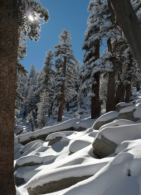
The amount of snow on the ground really started to increase above flat rock- about 2-3 inches at the 7,000ft mark. Snow was falling heavily. Routefinding was not an issue, as an indent of the trail was clearly visible under the snow and certain rocks and trees we remembered from previous climbs could be used as landmarks. There was also a faint indent of footprints in the snow, indicating that someone had been on Skyline the previous day or even earlier that morning. These footprints were quickly being obscured by the accumulation of falling snow.
At 7,400 ft, there were 5 inches of snow on the ground, which slowed our progress. Greg and I took turns breaking trail. We had planned to meet up with the rest of our group at the upper tram station by 8:30am. Now it looked like the three of us would be getting there much later, and a game of catch-up would ensue.
7,000 ft

momentary clearing


There were 6-7 inches of snow on The Traverse, with isolated drifts of 10 inches. Snow was still falling heavily and clouds were growing thicker. I was very surprised that wind speed was only about 15mph at most. I had tied snowshoes on my pack in the way that their ends were sticking out horizontally. Every time I walked between a narrow area of brush, the snowshoes would snap several branches forward, hitting me with a face full of snow.
I thought to myself that this hike was surreal. Never before had I hiked this trail in a snowstorm. This was one of those unique moments when something that had been experienced so many times before could be felt in a completely different way. It was like hiking Skyline again for the very first time.
starting on The Traverse


Coffman's Crag

The switchbacks above Coffman's Crag contained ~7 inches of snow with isolated pockets of 11 inches.


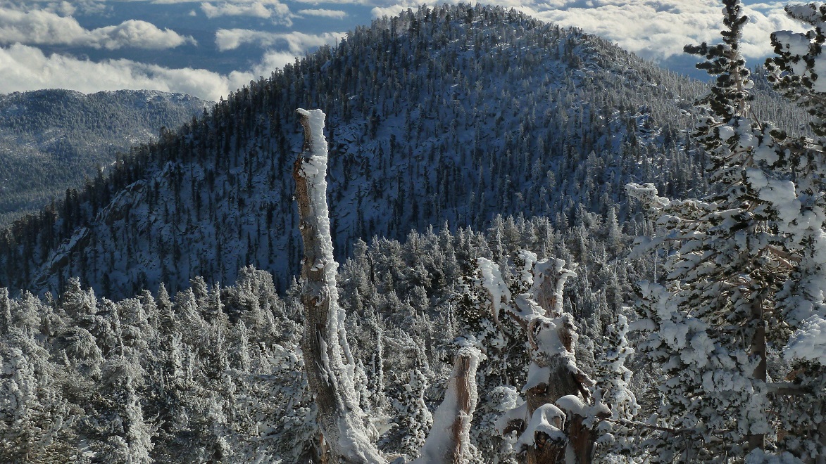
As we came closer to the entrance into Long Valley, we saw the sky clearing up ahead. When we got to Long Valley, it had completely cleared. I looked back down Skyline and was amazed to see that it was still cloudy and snowing heavily 50ft below us. It looked like the weather was staying below 8,000ft the whole time, and it hadn't snowed above 8,000ft since the previous day.
entrance to Long Valley

lots of rime ice on the higher peaks

We got to the ranger station at 9:25am and left at 9:45am after getting water and permits. We followed several snowshoe tracks, which contoured along the side of an obvious drainage of the Sid Davis Trail. The snowshoe group was supposedly 1hr15min ahead of us. After a quarter mile on the Sid Davis trail, I split up with Greg and Sung in order to go ahead and tell the snowshoe group that we had made it up Skyline and were headed up to them.
The Sid Davis "Trail" was pretty easygoing. The snowshoe group had left an obvious indent of tracks, compacted to a point where snowshoes probably weren't even necessary to comfortably walk in it.
just after Tamarack Valley

I met up with Serena and Eric about half a mile after Tamarack Valley. They said that the rest of the group was about 30 minutes ahead and headed up towards a saddle between Jean and San Jacinto peaks.
base of Jean Peak

climbing up


As I ascended towards Jean Peak, I caught a glimpse of the clouds we had climbed out of earlier that day. It was probably still snowing down there.

Pretty soon I heard voices from above. I looked up and saw the group of ~15 people. They were taking a break at the saddle, putting on snowshoes. Because of exposed rock on Jean's slopes, they had taken off their snowshoes and postholed up to the saddle. After securing our snowshoes, we turned south towards Jean. The air suddenly grew very cold as a steady wind picked up, blowing little pellets of ice off trees. The wind chill factor was around 5F.


The views from Jean Peak were amazing, better than anything I had seen before in the San Jacinto Mountains. The sun glittered off trees that were blasted with hoar frost. Cotton Candy clouds filled up surrounding valleys.
summit celebration


Views to live for!


We stayed on the summit for 20 minutes, then headed off north towards San Jacinto. The views from the ridge between Jean and San Jacinto were nothing less than spectacular. As we were heading back down Jean, we ran into Greg and Sung. Greg decided to quickly tag Jean and catch up to us at San Jacinto. Sung decided to skip Jean and head directly for San Jacinto.

Mt. San Gorgonio

just below San Jacinto Peak

San Jacinto Peak was very cold. The wind chill factor was in the negatives. Everyone wanted to just touch the summit and get off the mountain quick. Heres how the summit experience went:
Mihai: "Ok lets take the summit shot. Lets see- camera on the tripod, tripod on the pole. Nope. The pole is not staying. Lets put the pole in this crack and put the camera back on it and see if the pole stays upright. Hang on, this will take a few moments. Nope. The pole still keeps falling over. Alright, screw the pole. Lets put the camera on a rock and get the picture that way. Nope. The rock is coated with ice. The camera keeps slipping off. Lets try--- "
Everyone else: "HURRY UP MIHAI. I WANT TO GET OFF THIS MOUNTAIN. ITS TOO F***** COLD!!!!"
Jean Peak from San Jacinto Peak

It didn't matter how cold it was. I had to get my fair share of views! For every frozen finger, it was worth it!


We descended San Jacinto and headed into the hut to gain a brief respite from the cold. I hesitated at first because I didn't want to take off my snowshoes and put them back on a few moments later, but eventually gave in after glimpsing the invitingly warm interior of the hut.
After a few moments in the hut, we headed down the main trail, cutting the "Great Switchback" on our snowshoes.

Final Stats
16.6 miles
11,300/3,400 ft gain/loss

Weather Forecasts
Trailhead
1,500 ft along Skyline Trail (picnic tables)
4,900 ft along Skyline Trail
6,000 ft along Skyline Trail (Flat Rock)
7,800 ft along Skyline Trail (Coffman's Crag)
Long Valley to Round Valley
Jean Peak, San Jacinto Peak
Peakbagger Pages
Jean Peak
San Jacinto Peak
Summitpost Pages
Jean Peak
San Jacinto Peak
Other
Mt. San Jacinto message board
Live webcam from Long Valley Ranger Station
Palm Springs Aerial Tramway website
The rain was coming down in buckets on the way to the museum trailhead from San Diego. Even as we came through Gorgonio Pass, a steady rain was tapping against the windshield. As we pulled into the museum parking lot and met up with Greg, it decreased into a few sprinkles. The temperature was not bad, indicated as 48F on the car thermometer. We started hiking around 2:15am, packs weighed down with snowshoes and other heavy winter gear. After 15 minutes on the trail, it was getting too hot and I had to delayer.
The city lights below were reflecting off of clouds above, which looked like they were flowing off the slopes like giant waterfalls. The clouds were steadily making their way over the mountains in small bursts- thickening, then clearing. They got continually more dense as we made our way up the mountain. A few drops of rain fell here and there, but nothing strong enough to get us drenched. As we reached the 4,000ft mark, a dense cloud moved in and engulfed us. I had to be very careful to make sure we were still on the trail, as we couldn't use landmarks to navigate.
At 4,500 ft the isolated sprinkles had turned into a steady drizzle which was growing heavier. The drizzle turned into sleet at 4,900ft and finally snow at 5,000ft. At 5,000ft, the ground was covered with a very thin film of snow. The trail was still clearly visible. Flat rock had a light dusting of snow.
Flat Rock

The amount of snow on the ground really started to increase above flat rock- about 2-3 inches at the 7,000ft mark. Snow was falling heavily. Routefinding was not an issue, as an indent of the trail was clearly visible under the snow and certain rocks and trees we remembered from previous climbs could be used as landmarks. There was also a faint indent of footprints in the snow, indicating that someone had been on Skyline the previous day or even earlier that morning. These footprints were quickly being obscured by the accumulation of falling snow.
At 7,400 ft, there were 5 inches of snow on the ground, which slowed our progress. Greg and I took turns breaking trail. We had planned to meet up with the rest of our group at the upper tram station by 8:30am. Now it looked like the three of us would be getting there much later, and a game of catch-up would ensue.
7,000 ft

momentary clearing


I thought to myself that this hike was surreal. Never before had I hiked this trail in a snowstorm. This was one of those unique moments when something that had been experienced so many times before could be felt in a completely different way. It was like hiking Skyline again for the very first time.
starting on The Traverse


Coffman's Crag

The switchbacks above Coffman's Crag contained ~7 inches of snow with isolated pockets of 11 inches.


As we came closer to the entrance into Long Valley, we saw the sky clearing up ahead. When we got to Long Valley, it had completely cleared. I looked back down Skyline and was amazed to see that it was still cloudy and snowing heavily 50ft below us. It looked like the weather was staying below 8,000ft the whole time, and it hadn't snowed above 8,000ft since the previous day.
entrance to Long Valley

lots of rime ice on the higher peaks

We got to the ranger station at 9:25am and left at 9:45am after getting water and permits. We followed several snowshoe tracks, which contoured along the side of an obvious drainage of the Sid Davis Trail. The snowshoe group was supposedly 1hr15min ahead of us. After a quarter mile on the Sid Davis trail, I split up with Greg and Sung in order to go ahead and tell the snowshoe group that we had made it up Skyline and were headed up to them.
The Sid Davis "Trail" was pretty easygoing. The snowshoe group had left an obvious indent of tracks, compacted to a point where snowshoes probably weren't even necessary to comfortably walk in it.
just after Tamarack Valley

I met up with Serena and Eric about half a mile after Tamarack Valley. They said that the rest of the group was about 30 minutes ahead and headed up towards a saddle between Jean and San Jacinto peaks.
base of Jean Peak

climbing up


As I ascended towards Jean Peak, I caught a glimpse of the clouds we had climbed out of earlier that day. It was probably still snowing down there.

Pretty soon I heard voices from above. I looked up and saw the group of ~15 people. They were taking a break at the saddle, putting on snowshoes. Because of exposed rock on Jean's slopes, they had taken off their snowshoes and postholed up to the saddle. After securing our snowshoes, we turned south towards Jean. The air suddenly grew very cold as a steady wind picked up, blowing little pellets of ice off trees. The wind chill factor was around 5F.


The views from Jean Peak were amazing, better than anything I had seen before in the San Jacinto Mountains. The sun glittered off trees that were blasted with hoar frost. Cotton Candy clouds filled up surrounding valleys.
summit celebration


Views to live for!


We stayed on the summit for 20 minutes, then headed off north towards San Jacinto. The views from the ridge between Jean and San Jacinto were nothing less than spectacular. As we were heading back down Jean, we ran into Greg and Sung. Greg decided to quickly tag Jean and catch up to us at San Jacinto. Sung decided to skip Jean and head directly for San Jacinto.

Mt. San Gorgonio

just below San Jacinto Peak

San Jacinto Peak was very cold. The wind chill factor was in the negatives. Everyone wanted to just touch the summit and get off the mountain quick. Heres how the summit experience went:
Mihai: "Ok lets take the summit shot. Lets see- camera on the tripod, tripod on the pole. Nope. The pole is not staying. Lets put the pole in this crack and put the camera back on it and see if the pole stays upright. Hang on, this will take a few moments. Nope. The pole still keeps falling over. Alright, screw the pole. Lets put the camera on a rock and get the picture that way. Nope. The rock is coated with ice. The camera keeps slipping off. Lets try--- "
Everyone else: "HURRY UP MIHAI. I WANT TO GET OFF THIS MOUNTAIN. ITS TOO F***** COLD!!!!"
Jean Peak from San Jacinto Peak
It didn't matter how cold it was. I had to get my fair share of views! For every frozen finger, it was worth it!


We descended San Jacinto and headed into the hut to gain a brief respite from the cold. I hesitated at first because I didn't want to take off my snowshoes and put them back on a few moments later, but eventually gave in after glimpsing the invitingly warm interior of the hut.
After a few moments in the hut, we headed down the main trail, cutting the "Great Switchback" on our snowshoes.

Final Stats
16.6 miles
11,300/3,400 ft gain/loss
Weather Forecasts
Trailhead
1,500 ft along Skyline Trail (picnic tables)
4,900 ft along Skyline Trail
6,000 ft along Skyline Trail (Flat Rock)
7,800 ft along Skyline Trail (Coffman's Crag)
Long Valley to Round Valley
Jean Peak, San Jacinto Peak
Peakbagger Pages
Jean Peak
San Jacinto Peak
Summitpost Pages
Jean Peak
San Jacinto Peak
Other
Mt. San Jacinto message board
Live webcam from Long Valley Ranger Station
Palm Springs Aerial Tramway website
Yo What kind of gear do you bring up on a hike like that? A brief list would be mucho appreciatio
ReplyDelete