
day 2
August 5, 2017
Despite having over 11 hours of sleep the previous night, we were not packed up and moving until almost 8:30am which was not super efficient given the high chance of early afternoon thunderstorms. It took about 20 minutes to slog back up partially frozen sun cups to Lyell-Maclure Saddle. We heard some voices below, the first voices we had heard in 3 days that weren't our own. It looked like a large group was heading up to climb Lyell, likely via its standard class 3 Lyell Glacier/northern headwall route.
Mt. Lyell seen from camp

Maclure

slogging towards Lyell

We ascended Lyell via its northwest ridge, a short but very enjoyable climb up class 3-4 solid rock. There were plenty of ascent options on this ridge, with the terrain trending easier lower down and more difficult higher up. All too soon the fun climbing ended and we slogged up the summit plateau, a large ramp slanting upwards south.
start of Lyell's northwest ridge

northwest ridge scrambles


large group approaching Lyell

As the group reached the upper portions of the Lyell Glacier, they seemed confused as to where the standard class 3 portion up Lyell's northern headwall lay. I shouted down to them and pointed to the exact start of their route but it seemed like they were still confused, choosing to ignore this and huddle together to discuss something I could not discern from my location. Oh well. Sean and I then headed up to Lyell's summit to join Toshi. From here we could no longer see or hear the group.
Lyell's summit plateau

We had an enjoyable time on Lyell's summit, having a second breakfast and reading entries in the jammed packed summit register. The sky was cloudy and murky, but there were no signs that storms had began developing. The air did feel extremely humid so we knew this would change fast within a few hours.
looking southwest from Lyell

In our 2015 attempt of Convoluted Bliss, Mason and I had made it to Mt. Lyell and camped on its summit plateau before bailing. The sunset we saw that evening was one of my most memorable ever.


Descending Lyell's east ridge started off class 3 but quickly turned to class 4 as we got closer to the Lyell Glacier. Since the rock here was mostly solid, this descent was fun instead of dangerous. We heard a faint yell of "woooooo" in the distance and noticed several little figures clumsily glissading down the Lyell Glacier, awkwardly bouncing in and out of suncups. It looked like they had turned around before the class 3.


Lyell Spire was an interesting looking formation on the east ridge of Lyell, the highpoint of a south-to-north running buttress dividing the Lyell Glacier in two. This spire could easily be surmounted via its class 3 northwest or northeast ridges.

looking west from Lyell Spire

south-southeast

We then descended to the lowpoint between Mt. Lyell and Lyell Spire, crossed a few snowfields on Lyell Spire's south face, and quickly got onto the ridge joining Lyell Spire and Ragged Ridge. The first half of this ridge was simple talus walking. The second half involved some fun class 3 semi-loose rock where multiple route options existed.
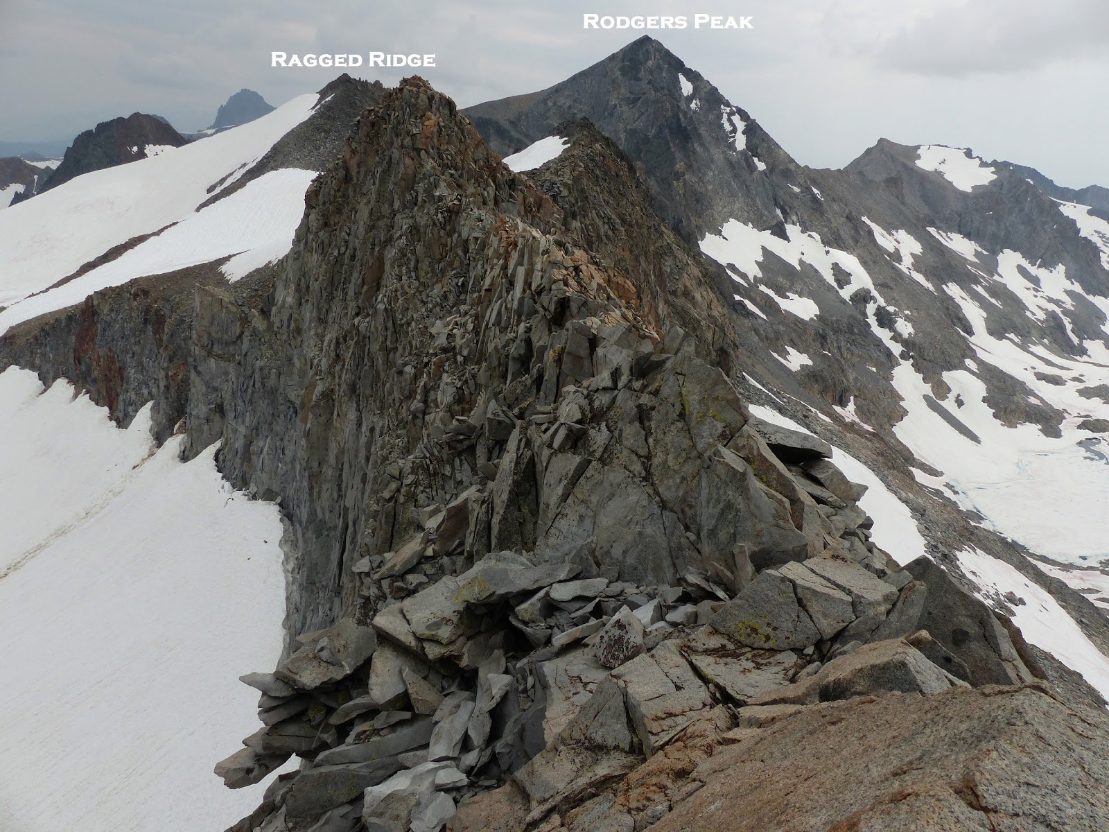
Ragged Ridge was named by Andy Smatko during his first ascent, one of the few peaks I had not seen him name after himself or his group members. I guess the permutations of decently sounding names must've eventually run out for someone who had claimed hundreds of first ascents throughout the Sierra. This peak contained an expansive view of Lyell Fork and the multitude of lakes scattered throughout its upper basin. Even on a gloomy day it looked pretty scenic. We looked up at the building thunder clouds and knew we weren't able to make it up and over Rodgers Peak today, but could at least climb the next peak (Marie Peak) before Rodgers and descend east to a large lake to camp.
Lyell Fork seen from Ragged Ridge

looking south

Since descending Ragged Ridge's south ridge directly looked dangerously loose, we slogged some scree slopes just east of the ridge crest, reaching the Ragged Ridge-Marie Peak saddle in what felt like a pretty short time.


Marie Peak's north ridge was easy up until the last 50 ft, where a super loose class 4 face climb up its east side was the easiest way up. The highpoint was a thin and loose ridge that felt ready to break apart with the smallest amount of force.

view north from Marie Peak

south

southwest

loose summit

Hail was already beginning to fall as we arrived back at the Ragged Ridge-Marie Peak Saddle. From here it was a short slog east to the south side of a large lake (11,746 ft). We were now getting accustomed to setting up camp as fast as we could, and finished up within 15 minutes just as the first heavy rain rolled in. There were not too many comfortable spots available as the ground was made up of small pointy rocks, but we made do with what there was.

It was only 2:40pm, by far the earliest we had stopped so far. Rain lashed down in torrents. My tent started leaking in a few spots and I rummaged through my pack for unused bags to place below the drips. It seemed like the centers of the worst storms were just south of Mt. Lyell, and multiple lighting bolts struck in that direction less than a mile away. One of them even struck halfway across the lake less than 500 ft away! The insanely loud cracking sound was startling enough to make me suddenly drop the food I was eating. I tried to sleep, but could not drift off due to the amount of sleep I had already gotten the previous night which really wasn't that long ago, so I stayed awake counting the seconds between lighting flashes and thunder to gauge how far away they were. By 5:30 pm, the rain had turned into light drizzle as patches of blue sky appeared. At 6pm we emerged from our tents and began cooking dinner. There was a short discussion about possibly continuing since the weather was now good, but we quickly decided against that since we wouldnt make it very far anyway with the little daylight we had left, and this was the last place we would have access to liquid water for a while. We sat outside eating slowly, looking up as the sun slowly faded on Rodger's north face. It had been a short day, but a fun one.
go to day 4
No comments:
Post a Comment