day 1
August 4, 2017
A weak sun shone through a thick layer of cirrus clouds as we packed our camp in the morning. It had rained a little more at night, but now everything was once again dry. Sometime after 8am, we were off, trudging up the first half of Simmons Sidewalk's northwest ridge, a 500 ft gain talus field to warm us up for the day.
The second half of the northwest ridge was a class 3-4 knife edge which was somewhat loose but also very fun in places. At the first major downclimb, we dropped 10 ft east (left) of the ridge, taking a short class 2-3 ramp which led down to a notch. From this notch, a multitude of short 10 ft class 4 moves led back onto the ridge crest where we mostly remained all the way to the peak, except for a short stretch where we dropped 10-15 ft west of the ridge before regaining it as soon as we could.
From Simmons Sidewalk, Simmons Peak loomed large and massive to the south. It contained three distinct towers from east to west, with its westernmost one being the highpoint. We traversed easy terrain below the first tower, climbed up and over the second one which was rated class 3+, and clambered up the third tower (or peak) which was class 2-3. Both Sean and Toshi felt like descending the second tower was more difficult than any terrain we had encountered on Simmons Sidewalk.
(same view as above from 2015)
descending second tower
looking southeast from Simmons Peak
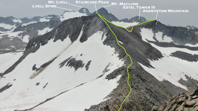
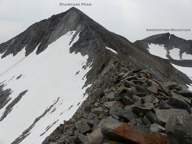
The ridge between Simmons and Staircase Peak was a little more tedious than it initially looked. Getting off Simmons involved weaving around several large loose boulders, followed by class 3 on talus. The last few hundred feet to Staircase was smooth going.
summit of Staircase Peak
looking back at Staircase from the Staircase-Andevetom saddle
looking north from Andevetom's summit
southwest
southeast
Next up was Estel Tower III, one of my favorite Sierra peaks which I had climbed two times previously. We mainly stayed on the class 3 ridge to the base of the tower up to a point ~50 ft below its summit, then took a large obvious ramp on its northwest side for about 40 ft. Several class 4 routes could be climbed from this ramp to the summit, with the easiest of these starting up from the western three quarters of the ramp. A few moves later, the fun was over all too soon.
northwest side ramp
awesome summit views
Now we faced Mt. Maclure's west ridge, a formidable looking feature which appeared very technical from afar. Last time I was here with Mason, we ascended a class 5.4 route up this ridge, but this time we were able to find another variation which required only up to class 4/ 4+. After Estel Tower, there were two prominent notches at the beginning of Maclure's west ridge, with the second of these only half visible from Estel Tower itself. We donned crampons and remained just north of the ridge crest itself on the Maclure Glacier before clambering up to that second notch. Cold and delicious blue colored water had pooled in small pockets on the bergschrunds of this glacier, and we gratefully recharged our bottles while being careful not to fall through thin ice.
Upon reaching the notch, we removed our crampons and began ascending the ridge along its southern side. The climbing was class 3+ at most. Sean sent down a few large boulders, with one being a close call as he had been using it as one of two crucial holds.
Once the ridge turned to class 5, we dropped less than 10 ft down its northern side onto loose class 4 conglomerated white rock. After climbing around the north side of a prominent white pyramid shaped tower, we located a loose notch made of the same conglomerated rock and dropped southwest for about 30 ft. A little bit of loose sidehilling brought us to the final headwall, a 300 ft fun class 4 scramble to the summit of Maclure.
climbing around the white pyramid
view from notch
Sean (in red) dropping down from the notch
final class 4 headwall (Sean and I took the green route while Toshi took the orange)
storm clouds starting to build
ascending headwall
We were having so much fun that we did not notice several dark thunderclouds developing within less than a 20 minute period until we had reached Maclure's summit. From there, the glory was spread out all around us, with heavy precipitation falling everywhere towards the north, east, and south. We hastily signed the register before proceeding down Maclure's class 3 southeast ridge, eager to get off the mountain before lightning started.
looking southeast from Maclure
southwest
Lyell Canyon getting drenched
Shortly after we left the summit, pea sized hail began falling. The rocks were quickly becoming slippery as hail began coming down more heavily and accumulating. The hail was now beginning to hurt as it came into contact with bare skin and I stopped briefly to put on a jacket, also leaving the helmet on for the same reason. We descended to the Lyell-Maclure Saddle (12,440 ft), surveying the land below us for places to camp. About half a mile northeast was a decent sized partially frozen lake with some slabs around it. We aimed for it, slipping and sliding over large sun cups on the Lyell Glacier. Eventually the hail turned to light rain for a brief respite. There were several good camping spots on the east side of the lake, and we made haste setting everything up as rain quickly grew heavier.
descending the Lyell Glacier
It was just before 6pm as the last of us crawled into our tents dripping wet. We went right to sleep as storms continued on into the night. We would all eat dinner at different times as storms came and went. At 1am, I poked my head outside my tent to see a weak moon filtering through clouds. A few more light showers would swing by after that before dissipating shortly before sunrise.
go to day 3


No comments:
Post a Comment