
August 5, 2016
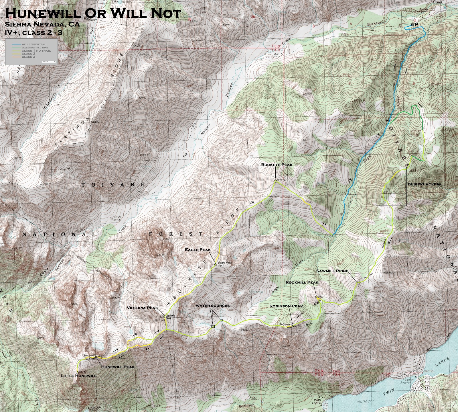
The Buckeye and Sawmill ridges sit roughly 8 miles southwest of Bridgeport, just north of Yosemite. Both ridges converge into a single ridge at Victoria Peak, forming the optimal U-shape of a traverse. It just so happened that Hunewill Peak, a peak for the 2016 Sierra Challenge, rested on this traverse, located on the west side of the route after the ridges converged. Mason and I decided that it would be a good idea to do the traverse on this day, hoping to meet up with some of the other Challenge participants on the summit of Hunewill. Because of this timing, we planned to start approaching from Buckeye Campground (just north of Twin Lakes) at 4am, climbing three extra peaks before reaching Hunewill (see map).
| Peak | Elevation | Topographic Prominence | Summit Coordinates (lat/lon) |
|---|---|---|---|
| Sawmill Ridge | 10,325 ft | 345 ft | 38.1757, -119.3675 |
| "Rockmill Peak" | 10,401 ft | 253 ft | 38.1725, -119.3794 |
| Robinson Peak | 10,793 ft | 413 ft | 38.1659, -119.3862 |
| Hunewill Peak | 11,713 ft | 773 ft | 38.1588, -119.4433 |
| "Little Hunewill" | 11,663 ft | 283 ft | 38.1552, -119.4487 |
| Victoria Peak | 11,706 ft | 206 ft | 38.1680, -119.4235 |
| Eagle Peak | 11,847 ft | 2,347 ft | 38.1799, -119.4085 |
| "Buckeye Peak" | 10,444 ft | 344 ft | 38.1992, -119.3912 |
Trailhead coordinates (lat/lon): 38.2347, -119.3515
With droopy eyes and sleep deprived faces, we started off from Buckeye (7,220 ft) at 4am, walking up a dusty pack trail with paralleled Eagle Creek upstream to the southwest. Eagle Creek was the main drainage between Buckeye and Sawmill Ridges, and after 2.3 miles we took an east-branching trail (8,200 ft) which headed up towards Sawmill Ridge. This second trail was rapidly getting overgrown, and would eventually disappear after reaching a meadow at 8,800 ft. By now the main crest of Sawmill Ridge was obvious and we ascended straight up it, whacking through some low lying aspen in the process.
sunrise from Sawmill Ridge


We eventually reached a bump labeled "9826T" on the 7.5' topo. Here the ridge became choked with large clumps of stubby bushes which were a nightmare to whack through, prompting us to veer slightly east of the bump where travel was more pleasant.
first view of Eagle Peak

Our first peak was the first prominent point on Sawmill Ridge, which contained spectacular views towards the Sawtooth Range, a subrange of the Sierra located to the south and across from Robinson Creek Canyon.

first glimpse of the Sawtooths

Twin Peaks

view south from Sawmill Ridge Peak


west
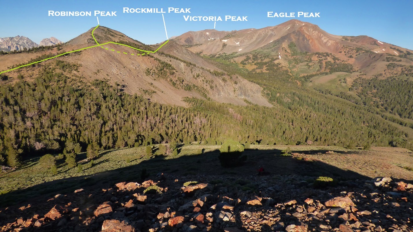
For the first time today, we sat down to grab a bite to eat, then started the pleasant walk to Rockmill Peak, the next highpoint on this traverse. The last 100 ft of Rockmill contained loose and shifty boulders, but it was over in a few minutes.
views before Rockmill


last 100 ft

looking down Eagle Creek drainage from Rockmill's summit

south


southwest

The walk over to Robinson was again pretty straightforward, staying along the connecting ridge. From Robinson, we attained our first good view towards Twin Lakes. We searched around for an old register that was said to be there, but didn't find it.
Robinson summit views


looking into Robinson Creek Canyon

From Robinson, we headed west across several meadows, staying well below the south side of Eagle Peak, stopping at one of two babbling brooks which served as our only clean water sources on the traverse. I filled up my large 2.8L bottle with brook water, later realizing that I had attained a worm in the bottle. Throughout the day, I would slurp the water cautiously, carefully steering the worm away from the bottle opening.


From the west end of the meadows, a large ramp continued west towards Victoria Peak. This was a straightforward "one foot in front of the other" type of deal, and we made it to the south shoulder of Victoria in no time. The actual summit was still a few minutes to the north, but we did not climb it at the moment since we would come back this way (this is where the two ridges merged). Spying Hunewill as the next peak to the west, we quickly boot-skied down Victoria's west ridge, running into Sean O'Rourke from the main Sierra Challenge group, having traversed over from Hunewill.
looking west towards Hunewill

Barney Lake

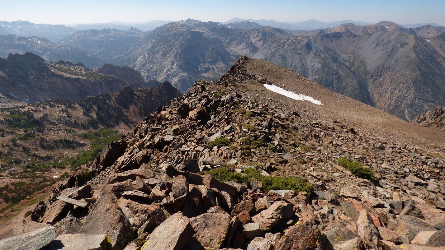
Shortly after descending from Victoria, the ridge grew increasingly rocky and turned to class 3, and soon class 4. When a class 5 pinnacle appeared ahead, we took a cruddy class 3 chute down 50 ft to the north, and remained level for a little bit before the ridge crest leveled out. It appeared to us that Sean had stayed lower to the north, avoiding this bit of tediousness.


class 3 crud chute

Shortly after regaining the ridge crest, we ran into Scott Barnes, who had also left the main Challenge group on Hunewill to traverse over to Robinson Peak. We had a short exchange on route beta, then continued on our ways. The east ridge of Hunewill was steep and blocky, but could be kept at class 2. By 12:50pm, Mason and I had reached the summit and were joined by a few other Challenge participants.
Hunewill's east ridge

view northeast from summit

south

southwest

Mason, Matt, and Ken

We remained on the summit for roughly 30 minutes, catching up on stuff since the previous year's Challenge. Seeing that we still had a long way to go, we soon made our way towards Little Hunewill, the westernmost peak on the traverse. This part was very straightforward, with Mason and I walking up a short boulder field to its summit, then ascending back up Hunewill Peak afterwards. The others descended a large sand gully heading south from the saddle between Hunewill and Little Hunewill.
view west from Little Hunewill

northeast

While ascending back over Hunewill, I climbed directly up and over the summit while Mason tried to save some elevation by contouring along its south side. We met up again on the east side, with Mason displaying some blood from a rock giving out, but was otherwise fine. We bypassed the class 5 part of the ridge between Hunewill and Victoria by staying north, then reascended Victoria's west ridge.
shortly before ascending Victoria

Although Victoria was not super topographically prominent (since all its prominence went to nearby Eagle Peak), it would contain better views than Eagle because the connecting ridge would block most of Eagle's western viewshed.
views from Victoria


About a third of the way between Victoria and Eagle was a volcanic gendarme that we weaved to the south side of, then followed the ridge crest to Eagle. I partially destroyed a cairn made of rocks and sticks while looking for a register, but did not come across one.
summit of Eagle

The last peak on the traverse (Buckeye Peak) could now be seen to the northeast, over 1,000 ft of elevation below. Getting over to it was straightforward enough, following the steady class 1 ridge. As expected, temperatures began gradually rising as we descended lower.

The summit of Buckeye Peak contained a surprisingly colorful view towards the desert.

looking back towards Eagle

last view of the Sawtooths

For descent, we used the main southeast ridge of Buckeye Peak, contouring along the west side of a rocky outcrop shortly after leaving Buckeye. This ridge (with a short section of bushwhacking near its toe) dropped us into Eagle Creek Canyon, picking up the trail which went along it. We plodded down this trail for sometime under 2 hours (for somewhere around 5 miles) before reaching the car at around sunset.
Final Stats
25.6 miles
8,730 ft gain/loss
Weather Forecasts
trailhead vicinity (7,000 ft)
8,200 ft
9,400 ft
10,800 ft
Summitpost Pages
Robinson Peak
Eagle Peak
Peakbagger Pages
Sawmill Ridge
Rockmill Peak
Robinson Peak
Hunewill Peak
Little Hunewill
Victoria Peak
Eagle Peak
Buckeye Peak
No comments:
Post a Comment