
August 3, 2016
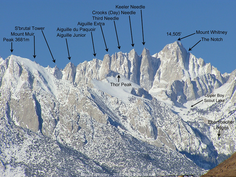
The Mt. Whitney Trail is undoubtedly one of the most popular and highly demanded trails in the Sierra, providing easy access to the 14,508 ft peak in a hiking distance of 10.8 miles one way. By Sierra standards, it is not a terribly exciting route, consisting of all trails and much crowds, but for those who are not mountaineers or do not get to experience the Sierra very often, it is a good introduction to the mountains and a simple way of getting them adjusted to high altitude travel. This was the case with Joseph, who had only hiked one sierra peak previously (Mt. Hoffmann in Yosemite). I used this day as an additional opportunity to tag a series of easy named pinnacles along the main massif (pictured below).
| Peak | Elevation | Topographic Prominence | Summit Coordinates (lat/lon) |
|---|---|---|---|
| Aiguille Junior | 13,920 ft | 150 ft | 36.5682, -118.2919 |
| Aiguille du Paquoir | 14,009 ft | 131 ft | 36.5708, -118.2914 |
| Keeler Needle | 14,271 ft | 196 ft | 36.5757, -118.2917 |
| Mt. Whitney | 14,508 ft | 10,079 ft | 36.5786, -118.2920 |
| Crooks Peak | 14,206 ft | 131 ft | 36.5746, -118.2906 |
| Third Needle | 14,080 ft | 40 ft | 36.5733, -118.2899 |
| Aiguille Extra | 14,000 ft | 80 ft | 36.5722, -118.2901 |
Getting to the trailhead: From Lone Pine off of Hwy 395, head west on Whitney Portal Rd for 13 miles to a parking area.
Trailhead coordinates (lat/lon): 36.586907, -118.240020
Jodie, Joseph, and I left Whitney Portal trailhead (8,630 ft) sometime around 2:15am, starting out with a smattering of other groups with headlamps blazing. Jodie mentioned feeling unusually tired, having succumbed to a gluten allergy just a few hours earlier. After 15 minutes of hiking, she told Joseph and I to go ahead. We planned to wait for her up at Outpost Camp (10,360 ft, 3.5 miles in).
We reached Outpost a short while later and snacked on various bits of junk food for roughly 30 minutes. Jodie eventually showed up saying that she felt slightly better, but motioned for us to keep going, hopefully meeting up again at Trail Camp (12,040 ft, 6 miles in).
The eastern horizon began to brighten as we hiked above 11,000 ft. Joseph was beginning to feel the effects of altitude, and our pace slowed considerably. We reached Trail Camp shortly before sunrise, and sat down to gorge on more junk food. The entire area was strewn with tents and hikers, some of which were standing outside staring groggily at the switchbacks above them. We waited there for over an hour, watching the sunrise and occasionally entertaining ourselves with a marmot which made repeated attempts to snatch our food.


An hour after sunrise, we decided to just press on, starting up the 99 switchbacks (or 97, as there seems to be much disagreement on the matter) above Trail Camp. Joseph was really beginning to feel the effects of altitude, having to rest after every 50 ft of walking, but repeatedly reassuring himself that he could press on. He became slightly worried when he would feel and hear a loud thumping in his head every time he began walking, but calmed down when I told him that the rapid strong heartbeat was a normal reaction to the thin air. It seemed like a standard day on Whitney, with various groups making their ways up the switchbacks with their heads down, and several JMT'ers hustling down the trail, hoping to return to the portal before afternoon heat would engulf it. The day was somewhat hazy due to smoke from a fire burning in the Santa Lucia Range several hundred miles to the west. This haze would gradually clear as the day went on and winds changed.

By 8:30am we had reached Trail Crest (13,770 ft, 8.5 miles in). This was where the trail intersected the main crest of the Whitney massif as well as the Sierra Crest. After Trail Crest, the trail dipped down for a short bit, then forked, with the left fork heading west towards Guitar Lake and right fork heading north towards Whitney, roughly 2 trail miles away. Not far after that, we passed by a rock formation known as S'brutal Tower, which I planned to climb on the way back.

Right after S'brutal began the series of pinnacles I was to climb, with Aiguille Junior coming in first. All of the six pinnacles from Aiguille Junior to Whitney would involve straightforward class 2 scrambling. Seeing that Joseph was on a straight shot on trail towards Whitney, I headed off to begin my pinnacle hunt.
Aiguille Junior seen from the trail

closer to summit

looking south from Aiguille Junior

north

Next up was Aiguille du Paquoir. I descended back to the trail and left it shortly after, arriving at the southern (lower) summit of Aiguille du Paquoir. This local highpoint contained a largely illegible register from 1956.

looking north from the lower southern summit

looking north from the higher northern summit


I descended back to the trail and decided to save the next three pinnacles for the way back, making my way over to Keeler Needle, located just south of the main Whitney summit.
looking northeast from Keeler

southeast

After Keeler, I headed back down and joined Joseph on the remaining 500 ft of ascent to Whitney's summit. He seemed overjoyed to have finally made it, having turned back from less than 2 miles away the previous year due to thunderstorms. We remained on the summit for over 3 hours, milling around and waiting for Jodie to reach us. Joseph felt sleepy and eventually headed into the summit hut for a nap after unsuccessfully being able to fall asleep outside.
view northeast from Whitney

south

southwest

summit hut

After the 3 hours had passed, we decided it was best to start heading down, seeing clouds starting to build overhead. I nabbed Crooks Peak, Third Needle, and Aiguille Extra on the way down, then absentmindedly passed by S'brutal tower, forgetting that I still needed to climb it, not remembering until I had gotten back to Trail Crest. Oh well, I thought. I needed to come back up here anyway for Trail Crest Tower which was class 5 and required a rope and partner. S'brutal was close by and wouldnt be hard to knock off on the same day.
heading down Whitney


Joseph was not used to snow in August.

moar needles!

almost to Crooks

looking north from Crooks

east

south

view north from Third Needle

easy terrain to Aiguille Extra

view north from Aiguille Extra

east

south

views from trail north of Trail Crest


heading back down the 99 switchbacks


By 5pm-ish, we had gotten back to the trailhead. Jodie had left a note there, mentioning that she had turned back before 11,000 ft when someone from another group said that her face looked extremely pale. We packed up and headed back down into Lone Pine for food. Our timing back down the mountain had been perfect, as the first few rumbles of thunder sounded to the west.
Stats (Whitney Trail only, not including pinnacles)
21.6 miles
6,100 ft gain/loss
Final Stats (including pinnacles)
22.3 miles
7,000 ft gain/loss

Weather Forecasts
Trailhead (8,630 ft)
Outpost Camp (10,360 ft)
Trail Camp (12,040 ft)
summit (14,508 ft)
Peakbagger Pages
Aiguille Junior
Aiguille du Paquoir
Keeler Needle
Mt. Whitney
Crooks Peak
Third Needle
Aiguille Extra
Summitpost Pages
Keeler Needle
Mt. Whitney
Crooks Peak
No comments:
Post a Comment