
August 16, 2014
About 25-30 of us gathered up at Rush Creek Trailhead (7,250 ft) near Silver Lake at 6am for day 2 of the 2014 Sierra Challenge. Today's Challenge peak was Mt. Andrea Lawrence, a 12,000 ft peak 2 miles northeast of Donohue Pass. This peak was only recently named in 2008 in honor of a local environmentalist.
| Peak | Elevation | Topographic Prominence | Summit Coordinates (lat/lon) |
|---|---|---|---|
| Donohue Peak | 12,023 ft | 483 ft | 37.775086, -119.230463 |
| Mt. Andrea Lawrence | 12,245 ft | 825 ft | 37.77933, -119.220328 |
| Koip Crest Peak | 12,651 ft | 111 ft | 37.793185, -119.204707 |
| Blacktop Peak | 12,720 ft | 400 ft | 37.793887, -119.196097 |
| Mt. Frandom | 12,560 ft | 208 ft | 37.804003, -119.200974 |
| Kuna Peak | 13,002 ft | 1,942 ft | 37.812906, -119.208275 |
| Koip Peak | 12,962 ft | 182 ft | 37.813634, -119.201831 |
| Parker Peak | 12,861 ft | 590 ft | 37.814293, -119.184451 |
| Mt. Wood | 12,657 ft | 197 ft | 37.80931, -119.165955 |
Getting to the trailhead
Trailhead coordinates (lat/lon): 37.783163, -119.127902
Rush Creek Trailhead (photo by Bob Burd)

Today was my big day. Looking at the map, I had noticed a long string of peaks between Donohue peak and Mt.Wood. Six of these would qualify as bonus peaks. I planned to first tag Donohue Peak before traversing the ridge to Andrea Lawrence, then traverse along a ridge with an unknown difficulty which connected Andrea Lawrence to Blacktop Peak. The ridge between Blacktop and Kuna was said to be an arduous class 4 traverse. The terrain would then ease up between Kuna and Wood- a little reprieve from the steep climbing. Finally, I would need to drop down the east side of Wood for a grueling descent on loose scree and bushwhacking, dropping over 5,000 ft of elevation to a north-south running pack trail. Once on the trail, I would turn right (south) and travel a short distance to its end back at Rush Creek Trailhead.
The sun rose as our large group made its way up the dusty trail, nicely illuminating Carson peak. Less than a mile after leaving the trailhead, we intersected some tram tracks, and shortcuted up them to meet up with the trail again a few hundred feet of elevation later just below the large concrete dam on the northern end of Agnew Lake. For the next several miles, we continued to follow the dusty trail around the north sides of Agnew Lake, Gem Lake, and Waugh Lake. Due to drought, every one of those lakes had water levels between 10-20 ft lower than their usual water lines.
hiking up tram tracks

Gem Lake


Waugh Lake


As we hiked around the north side of Waugh Lake, the two white granite summits of Donohue Peak (left) and Mt. Andrea Lawrence (right) appeared to the northwest. Once at the northwest side of the lake, we left the trail (7.3 miles from the trailhead) and headed northwest towards the peaks across gentle rolling terrain. Since I planned to climb Donohue first, I angled towards the peak on the left.
above Waugh Lake

Donohue and Andrea Lawrence through the trees

views of Banner Peak (left) and Mt. Ritter (right)


To get up Donohue Peak, I located a cascading creek which drained from a lake up above in the basin between Donohue and Andrea Lawrence, and continued upwards following the creek until I found myself at the base of Donohue's southeast ridge.
Donohue's southeast ridge

view south

The southeast ridge turned out to be a highly enjoyable class 3-4 scramble. The first few hundred feet of it started off as blocky class 4 requiring several foot jams and mantle moves. As the ridge went on, it became exposed class 5 near the summit. Dropping about 20 ft down the left (south) side of the ridge, I was able to locate several class 3 routes which led up to the summit.
base of the ridge

class 4 section

fun scrambling


The summit views were great, providing an expansive panorama of the Ritter Range, Sierra Crest, Koip Crest, and Lyell Canyon.
view south-southeast from summit

Banner/Ritter closeup

northwest towards Lyell Canyon

northeast

southeast

benchmark

Under the summit cairn I located a small plastic box with no lid and nothing inside. This had to be part of the register. After poking around for a bit, I found a plastic bag jammed into a crack which contained the register. Someone had gotten the smart idea to fill the bag with Starbursts, and it looked like a marmot or some other rodent had gotten into it. The bag and book were partially chewed up, and it looked like the marmot had vomited some of the Starbursts onto a few pages of the register book.

The traverse over to Andrea Lawrence along the connecting ridge was pretty straightforward. The descent of Donohue's northwest ridge involved some class 3 slabby and blocky terrain. For Andrea Lawrence's west ridge, I remained slightly left of the ridge crest on bouldery class 2 terrain in order to avoid a few pinnacles.
Andrea Lawrence's west ridge

I reached the summit of Andrea Lawrence to see a few participants standing on the summit block and a few others sitting below chowing down on energy bars and sandwiches.

view east-northeast from summit

south-southeast

southwest

northeast

In the 15 minutes that I remained on the summit, a few more participants made their ways to the summit for a total of seven by the time Bob snapped the group photo. A total of around 20 participants would summit later that day.
A few of us had heard about a fancy register which was recently placed on the summit. We were not able to find anything. Luckily Jonathan had a spare register ready to go.

To the northeast rose the large dark mass of Koip Crest Peak's southeast face. It was made up of several ribs and steep gullies. I descended Andrea Lawrence's north ridge a short distance to the lowpoint between Andrea Lawrence and a lower highpoint to the north. After dropping east down a short class 3 crud gully, I headed in a general NNE direction towards the base of Koip Crest Peak's southeast face. Along the way, I walked through a large meadow with several babbling brooks which drained into a large lake downstream. This would be my last water source for the remainder of the day.


I headed up a large gully immediately south (right) of Koip Crest Peak's west ridge. While the middle of the gully was loose, the sides contained much more solid rock.

As the gully neared its end at a large headwall, I headed right, climbed over a class 4 rib, and traversed across a small exposed ledge which wrapped around into the next major gully. A short section of class 3 up this gully brought me to the summit plateau, where I turned left and walked a short distance up to Koip Crest Peak's summit.


view southwest from Koip Crest Peak

north
east

Blacktop Peak was a short walk away to the east across its giant summit plateau. I practically destroyed the summit cairn, ransacking it in an attempt find the old 1976 MacLeod/Lilley summit register which Bob had mentioned in one of his trip reports, but it was nowhere to be found. I sat down on the summit for a quick lunch break, looking northwest and studying the serrated ridge which connected the Koip Crest Peak/Blacktop Peak plateau to Kuna Peak. It looked tedious but fun.
view south from Blacktop Peak

northwest

To get to the start of the traverse, I headed to the northern highpoint on the plateau between Kuna Crest Peak and Blacktop Peak, and headed north onto the ridge. This ridge was full of loose metamorphic ribs and pinnacles, requiring a great number of small ups and downs. Some of it was fun and exposed, and other parts of it were awful slogs around the sides of pinnacles. By going around some of the more sketchy and loose looking pinnacles, I was able to keep the difficulty to class 4 at most.
view from the start of the traverse

along the ridge


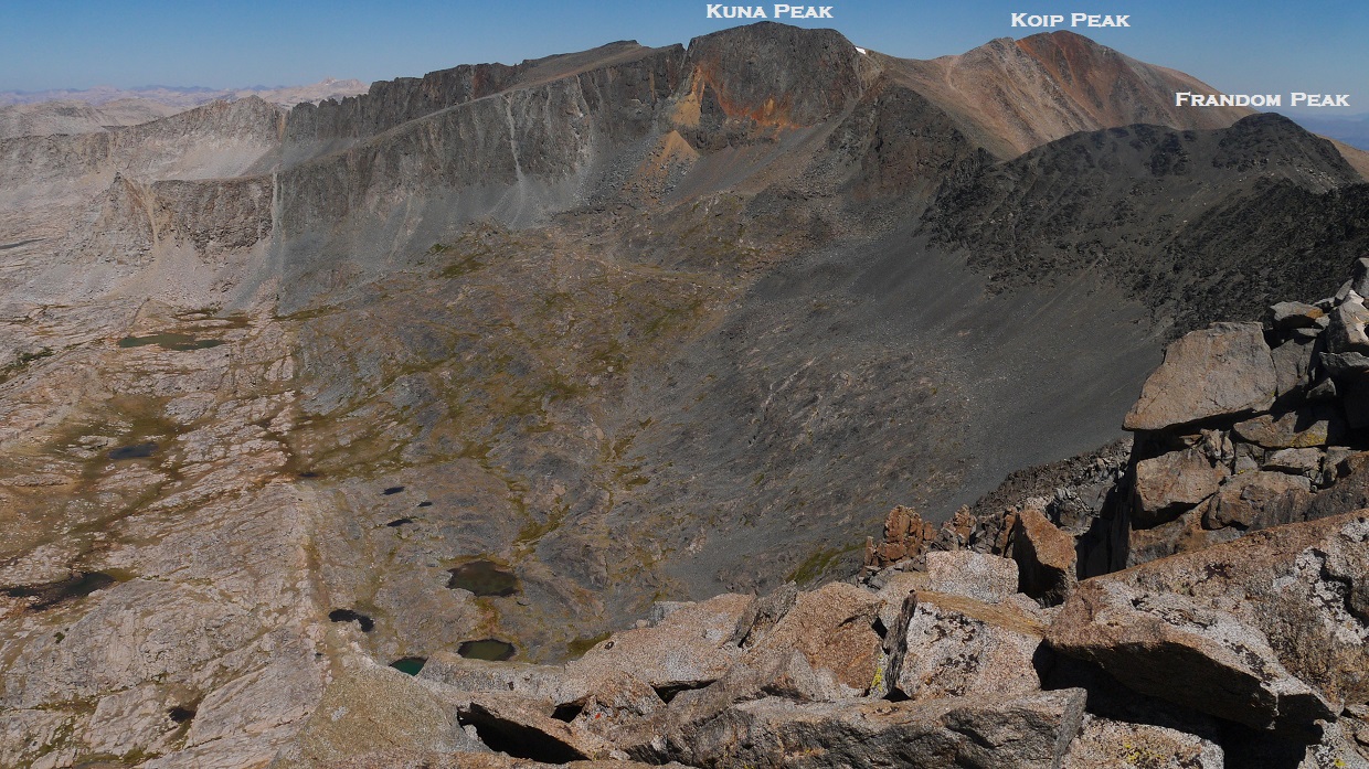
About 30 minutes after starting the traverse, I reached a large bump in the ridge- the highest point between Blacktop and Kuna, and decided to check out its summit. This bump was located approximately halfway across the traverse. To my surprise, there was a small register on its summit bearing the name "Mt. Frandom."

view northeast from Mt. Frandom

southeast

south

southwest

northwest

The remainder of the traverse to Kuna Peak turned out to be easy class 1-2 and went fairly quickly.

I reached the summit of Kuna and was surprised to not find a register. I had been on this peak just a year earlier and there had been a large ammo box at the summit. To the east, a small human figure could be seen standing on Koip Peak.
view south from Kuna Peak

northwest

east

I made my way to Koip Peak to find JD's fiance Liz resting on the summit. Earlier that morning, Liz had branched off on the trail to Gem Pass north of Gem Lake, then headed up to Koip Peak Pass and finally Koip Peak. JD had planned to bag Andrea Lawrence first and then meet her at Koip Peak Pass. Together, they would summit Koip, then head east to Parker and Wood. We could now see a small figure standing on Kuna Peak which had to be JD.
view southeast from Koip Peak

south

west

west-northwest

northwest

northeast

east

Getting from Koip to Wood was straightforward. All I had to do was continue east along the class 1 ridge to Wood.
Koip Peak Pass (saddle between Koip and Parker)

Parker Peak summit

view south from Parker

east

northeast

east

halfway between Parker and Wood

Mono Lake

view north from Mt. Wood

northeast

southeast

Now it was time for the fun part: descending over 5,000 ft of elevation down Mt. Wood's east face. I started by descending the ramp southeast of wood for about 0.4 miles, then headed east to start down an enormous scree slope which would take about an hour to descend.
looking down the scree slope

On and on went the scree slope, which was composed of clinky metamorphic rock and marbles. It wasnt difficult at all (class 2), but very tedious. Beginning at ~10,800 ft, the scree was replaced with slightly softer ground and desert shrubs (mostly sage). These shrubs slowed down the descent slightly, but at least they were soft on the feet.

As I got to ~8,300 ft, a mass of green appeared up ahead, and I found myself bushwhacking through thick groves of aspen. Shortly after, the pack trail came into view and I gladly hurried over to it (~8,060 ft). From there, I headed south (right) on the park trail and gladly jogged the remaining 1.1 miles to the trailhead.
view from pack trail

back at the trailhead- 4:45pm

Final Stats
20.5 miles
10,020 ft gain/loss

Weather Forecasts
Trailhead
Agnew/Gem/Waugh lakes
all peaks
Peakbagger Pages
Donohue Peak
Mt. Andrea Lawrence
Koip Crest Peak
Blacktop Peak
Mt. Frandom
Kuna Peak
Koip Peak
Parker Peak
Mt. Wood
Summitpost Pages
Donohue Peak
Mt. Andrea Lawrence
Blacktop Peak
Kuna Peak
Koip Peak
Parker Peak
Mt. Wood
Other
Bob Burd's trip report
JD's photos
Ansel Adams Wilderness
High Sierra Topix message board
Great TR and annotated pics - thanks! Checking it out for Andrea Lawrence beta
ReplyDelete