
June 15-17, 2014
At 14,411 ft of elevation and containing 13,222 ft of clean topographic prominence, Mt. Rainier is the highest mountain in the Cascade range and the 21st most prominent mountain in the world. With its 26 major glaciers, Mt. Rainier is also the most glaciated mountain in the southern half of North America. The mountain offers much in terms of mountaineering, containing anything from couple day walk-ups to multi day ice climbs.
The Disappointment Cleaver route (see map) is the easiest and most popular route up the mountain, with a total length of 14.8 miles and elevation gain of 9,600 ft. Most of it is class 1, with a few scattered class 2 sections. The main difficulties of this route involve weather, crevasses, and possible avalanches. Start from the visitor center parking lot in Paradise (5,430 ft). Take the well-traveled Skyline Trail to the base of the Muir Snowfield (7,200 ft, 0.1 mi WNW of McClure Rock), and continue up the snowfield to Camp Muir (10,100 ft). The total distance from the trailhead to Camp Muir is roughly 4.1 miles. From Camp Muir, head NNW across the Cowlitz Glacier to Cathedral Gap (10,710 ft)- the lower of two prominent gaps visible from camp (the upper one is known as Cadaver Gap). The last few hundred feet before Cathedral gap may contain somewhat loose scree in late spring and summer. From Cathedral Gap, Disappointment Cleaver should be visible as the long sliver of exposed rock to the northwest. Head a short distance WNW across the heavily crevassed Ingraham Glacier to Ingraham Flats (11,050 ft)- the second most popular campsite on the route. From there, head north to a "soft spot" just above the base of Disappointment Cleaver, then up onto the cleaver itself. The bottom half of the cleaver may contain fixed ropes during high season (typically from June to August). Once on the cleaver (which may contain loose rock during summer months), follow it to its western end (12,370 ft), then continue in a general NNW direction up the Emmons Glacier, ascending to the southeast crater rim (14,200 ft). Walk northwest across the crater to the true summit (14,411 ft).
During late spring and summer months, there will likely be a flagged snow trail extending from where the snow starts all the way up to the summit. Although this trail will mitigate the need for much routefinding, please do not completely rely on it! The weather can change at any moment and visibility can drop to a few feet, or a summer snowstorm could cover up the trail completely. Maps and GPS can be very helpful in these situations.
| Peak | Elevation | Topographic Prominence | Summit Coordinates (lat/lon) |
|---|---|---|---|
| Muir Peak | 10,188 ft | 98 ft | 46.835272, -121.730962 |
| Mt. Rainier | 14,411 ft | 13,222 ft | 46.852947, -121.760424 |
| Anvil Rock | 9,584 ft | 44 ft | 46.829641, -121.725631 |
| The Sugarloaf | 7,820 ft | 31 ft | 46.813703, -121.721735 |
| McClure Rock | 7,385 ft | 20 ft | 46.808642, -121.722887 |
Getting to the trailhead: Take the southwest entrance to the large parking lot at the Paradise visitor center
Trailhead coordinates: 46.786351, -121.736411
Craig, Sung, Mairi, Jeff, Eric, Marian, Mihai, and I headed up towards Camp Muir from the Paradise trailhead on Sunday morning at 8:30 am. There was a thick layer of snow down to the parking lot, and we lightly postholed up a well defined snow trail from the start.
Paradise trailhead


As we hit the Muir Snowfield, the wind picked up, the clouds darkened, and it began to snow. Visibility dropped to 20 ft at times. Everything around us was pure white. It was like walking in a dream.

We reached Camp Muir at around 1:30 pm, and promptly began checking the place out. Since the Muir Hut was still empty, most of the group opted to camp in there. For the next few hours, we sat around chatting and melting snow for drinking water. As more people arrived and the hut crowded up, Marian and I decided to camp outside to avoid all the hustle and bustle.
view of the east side of Camp Muir (west side contains guide service & ranger cabins)


At around 6pm the clouds cleared, revealing the upper mountain.


Since it was still pretty early, I decided to head northwest up the Cowlitz Cleaver and check out a rock formation labeled as "Beehive" on the topo map. The hike up to the base of the Beehive was easy, containing class 2 semi-loose rock and small portions of the Cowlitz Glacier.

views from ascent


After checking all sides of the Beehive, I found its southern side to contain the easiest route up. The climbing was all class 4 until a tight class 5 chimney ~8 ft below the highpoint. I remained there for some minutes, debating whether or not I should go for it, and eventually decided not to risk it. The rock was very loose and difficult to trust, and a fall would likely be fatal.

views from descent


There was still plenty of daylight remaining as I reached camp, so I headed east to tag Muir Peak- a small unofficially named peaklet located a few minutes away. From camp, two bumps appeared to the east. The further one was Muir Peak. The closer one contained a memorial to Jaine Diepenbrock, who died in an avalanche below Cadaver Gap on March 4, 1979.

Muir Peak

After tagging Muir Peak, I headed back to camp and crawled into bed, hoping to get at least a few hours of sleep before the 12am wake up time.
Before I knew it, the entire camp was filled with headlamps and voices, and I stumbled out of the tent into crisp early morning air. There were roughly 30 people outside getting ready. By 1:40 am, everyone (including us) were off. Our group headed up in two rope teams of four, ascending at a very slow and steady pace.
As we reached Cathedral Gap, we could see the dark mass of Disappointment Cleaver in the distance and a long string of headlamps heading across Ingraham Flats. The first half of the cleaver contained fixed lines which were not necessary given the light terrain, but were put there by previous guide services in order to account for the lowest common denominator among their clients. As we reached the upper half of Disappointment Clever, we were repeatedly blasted with strong gusts of wind from the northeast. Out came the balaclavas. A few moments later, I was very glad to finally see the tiny speck of sun make its way over the horizon.
top of Disappointment Cleaver

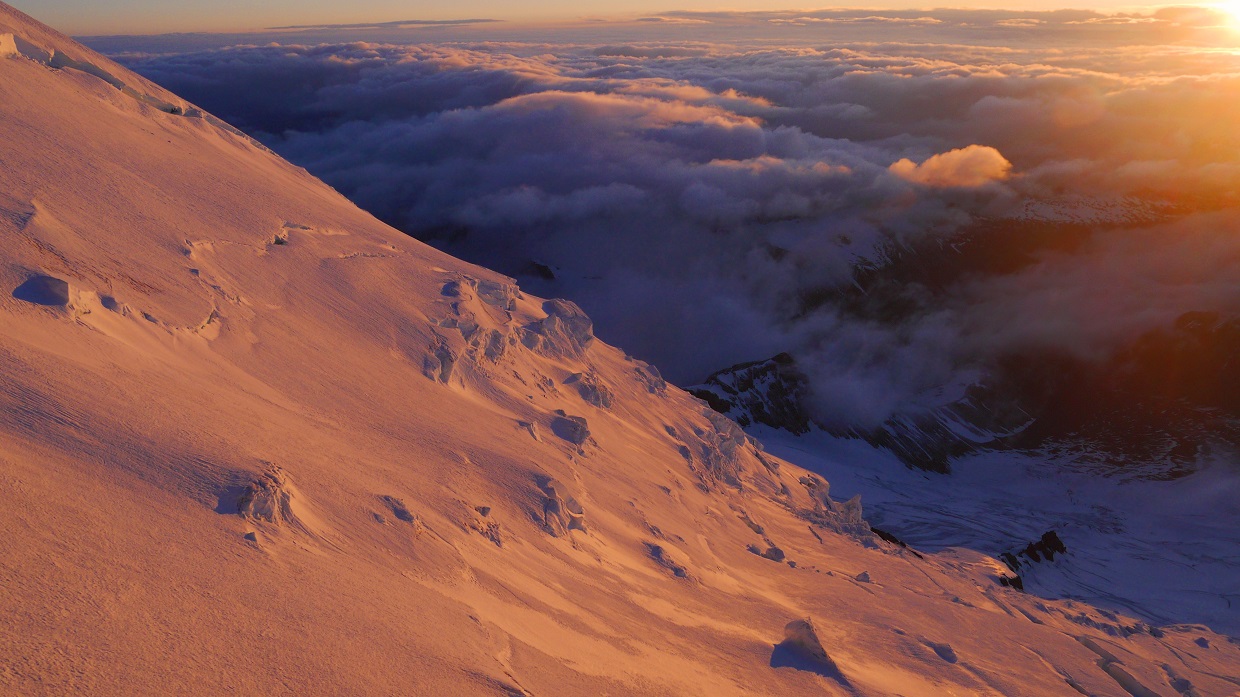
sunrise from ~12,400 ft


Gibraltar Rock and Mt. Adams

As we continued up the Emmons Glacier, the wind continued to scream. At times, small lenticular clouds formed around us. The climbing itself wasnt too exciting- just one step in front of the other. The views, however, were pretty amazing.


arriving at the southeast crater rim

Craig approaching the summit

We all stood around at the summit for a short moment, celebrating and taking a few quick group photos. After a few minutes, we headed back down to get out of the wind.
team on the summit (photo by Mihai Giurgiulescu)

summit panorama (photo by Mihai Giurgiulescu)

view south from summit

northwest (Liberty Cap is the highpoint)

northeast

east

views from descent


By early afternoon, everyone had gotten back to Camp Muir. A light steady snow had began to fall. Most people in the group did not want to hike back down that day, so we spent the rest of the day hanging around at camp.
We woke up the next morning to find roughly an foot of extra snow on the ground. Several groups of climbers could be seen trudging back to camp from Cathedral Gap, having turned around due to heightened avalanche danger. It did not seem like anyone had made it to the summit.
good morning!


small avalanche on Gibraltar Rock

the false summit of Muir Peak

By 8am, everyone was packed up and heading down from camp. The new snow made for some nice and easy heel plunging.


On the way down, we took a slight detour to tag Anvil Rock- a rocky outcropping located 0.5 mi SE of Camp Muir. The views from this seemingly insignificant feature were pretty stunning.


Nisqually Glacier icefall

looking back at Anvil Rock


Below Anvil Rock were two more features: The Sugarloaf and McClure Rock. Both of them were located a short distance east of the Muir Snowfield and contained easy class 2 terrain at most.


summit of The Sugarloaf


view of Rainier

McClure Rock

another view of Rainier

summit of McClure Rock

looking towards Cowlitz Rocks

battered benchmark

more views


After McClure Rock, we headed towards the trailhead, plunging into a sheet of thick misty clouds.

Final Stats
16.6 miles
11,060 ft gain/loss

Disappointment Cleaver route (by itself)
14.8 miles
9,600 ft gain/loss

Weather Forecasts
Trailhead
6,560 ft
Camp Muir
summit area (NWS forecast)
summit area (Mountainforecast)
Peakbagger Pages
Muir Peak
Mt. Rainier
Anvil Rock
The Sugarloaf (note: The coordinates and location of this peak on the provided map are incorrect)
McClure Rock
Summitpost Pages
Muir Peak
Mt. Rainier
Other
Mt. Rainier National Park
Mt. Rainier webcams
Cascade Climbers
Great trip report and photos
ReplyDeleteWhat an epic climb. With so many permanent glaciers, Rainier seems like the closest thing to the seven summits in the continental US, and the scariest (at least for me). Thanks for all the info and photos! Nice work. I am considering an assault on Rainier in the future, but I'm honestly still on the fence and may opt for one of guided expeditions.
ReplyDelete