Mt. Sill via Swiss Arete, Mt. Robinson

back to home page

June 28-29, 2014
The Swiss Arete (or north buttress) of Mt. Sill forms a striking feature which divides the northeastern and northwestern faces of the mountain. This short and sweet classic Sierra climb is perfect for anyone who is just getting into technical climbing.

Swiss Arete viewed from Glacier Notch


PeakElevationTopographic ProminenceSummit Coordinates (lat/lon)
Mt. Sill14,153 ft413 ft37.095968, -118.503212
Mt. Robinson12,967 ft387 ft37.117836, -118.517326

Getting to the trailhead: From Big Pine, turn west onto W. Crocker Street, which will soon turn into Glacier Lodge Rd. Travel 11 miles to the end of this road. This is the day use trailhead. The overnight parking lot can be found a half mile back on the north side of the road.

Trailhead coordinates (lat/lon): 37.128314, -118.427643

Adam and I began heading up the trail from the overnight trailhead shortly after 6am Saturday. Our plan was to climb the Swiss Arete that day, and bag a nearby peak Sunday morning before heading out (see map).

Big Pine Creek overnight trailhead


From the trailhead (7,680 ft), we took the trail 7.3 miles up the North Fork of Big Pine Creek past a few of the Big Pine Lakes to a spot shortly after Third Lake where the Glacier Trail branched off to the southwest, marked by a sign. From there, we took the Glacier Trail 0.9 miles to Sam Mack Meadow (11,000 ft). Shortly after reaching the meadow, a small trail branched off to the left, marked by a sign that simply read "trail." This trail meandered in a general southern direction, petering out 1.2 miles later at a spot approximately 0.5 miles NE of Glacier Lake. From there, we continued in a general SSW direction, aiming for a wide shallow saddle at the base of Mt. Gayley's northwest ridge known as "Gayley Saddle" (12,380 ft). We ended up setting up camp a short distance away on a large flat rock not far from the outlet of Glacier Lake.

views from South Fork Trail


Temple Crag and Second Lake


Sam Mack Meadow


Big Pine Lakes seen from the trail above Sam Mack Meadow


heading towards Gayley Saddle


our route up Sill from camp, seen from Gayley Saddle


Glacier Lake


From Gayley Saddle, the key is to locate a large class 2-3 garbage gully heading up to Glacier Notch (13,150 ft). At first, the gully is not apparent, but as one heads south from Gayley Saddle, it will appear very clearly to the left (east).


looking up at the route from Glacier Notch (consult this photo topo for more detailed information on the technical section).


The standard start for the Swiss Arete begins at ~13,500 ft, about halfway up the North couloir. We chose to start lower down on the Arete at the ~13,300 ft level due both to a recommendation by someone who posted the route on Summitpost and our unwillingness to walk up the North Couloir with its slippery suncup-laden snow.

Shortly after we got onto the arete, the terrain quickly turned to class 4-5 rock which was pretty solid. We put on our rock shoes and scrambled up this terrain which turned out to be pretty fun.


After a few sections of low class 5 cracks, the ridge leveled out a bit for some fun class 3-4 scrambling.


The actual climb began as the ridge suddenly steepened. P1 (5.5-5.6) was a fun warm up to the route.


P1 ended at a large ledge just below a rock split by a large crack. P2 traversed a ledge to the right of this rock, then ascended some fun 5.7 cracks around the left corner to another ledge.

first half of P2


P3 started off similar to P2, but contained a slightly awkward 5.6 step-across at the start onto a ledge on the right side of the arete. From there, there were two options. Option 1 was to keep following the ledge to the right around a corner to the standard 5.7 crux crack. Option 2 was to climb a short 5.8 crack visible from the step-across. We ended up taking the second option.


afternoon shot of the Palisade Glacier


P3 ended at a great ledge split by several cracks. From there, the remaining two pitches were pretty simple and self explanatory. They involved mainly class 4 rock with a few low class 5 moves, and contained many possible variations.

P4 and P5 seen from the great ledge


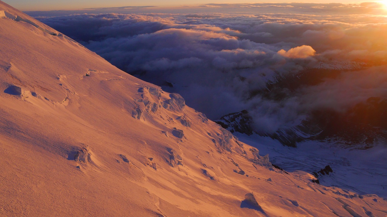
We topped out on the summit of Mt. Sill less than an hour before sunset, both feeling fairly exhausted.

summit views


Our descent was via the standard North Couloir route. From the summit, we headed a few hundred feet down the southwest ridge to the ~13,900 ft level, where a cairn marked a small notch where we would turn right onto the northwest face. From the notch, a short class 4 downclimb led to a small semi-exposed ledge which headed across the northwest face to the notch between Mt. Sill and Apex Peak. From the notch, a quick slog down the North Couloir brought us back to Glacier Notch, at which we retraced our steps back to our camp near Glacier Lake.

walking across the ledge


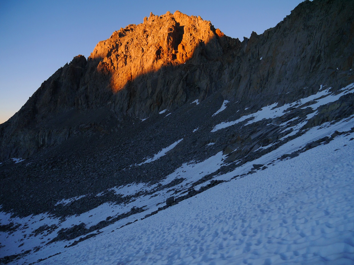
sunset glow on Mt. Gayley


Sometime around midnight, we were awakened by two people on a ridge west of camp who were shouting and making whistling noises. We later found out that a member of their party had sustained a leg injury which prevented them from walking. The other two had hiked back down to their camp at Sam Mack Meadow to retrieve his overnight gear since the helicopter would not arrive till morning. All the yelling and whistling was from their attempts to locate him (see accident report).

The next morning, we were treated to a spectacular sunrise which lit up the surrounding Palisade peaks


We now had half of the day to do some peakbagging. Adam still needed to climb Mt. Gayley which I had climbed in 2012, and I still needed Mt. Robinson which Adam had climbed in 2008. We split off to climb our separate peaks, planning to meet back up either at Sam Mack Meadow or the trailhead.

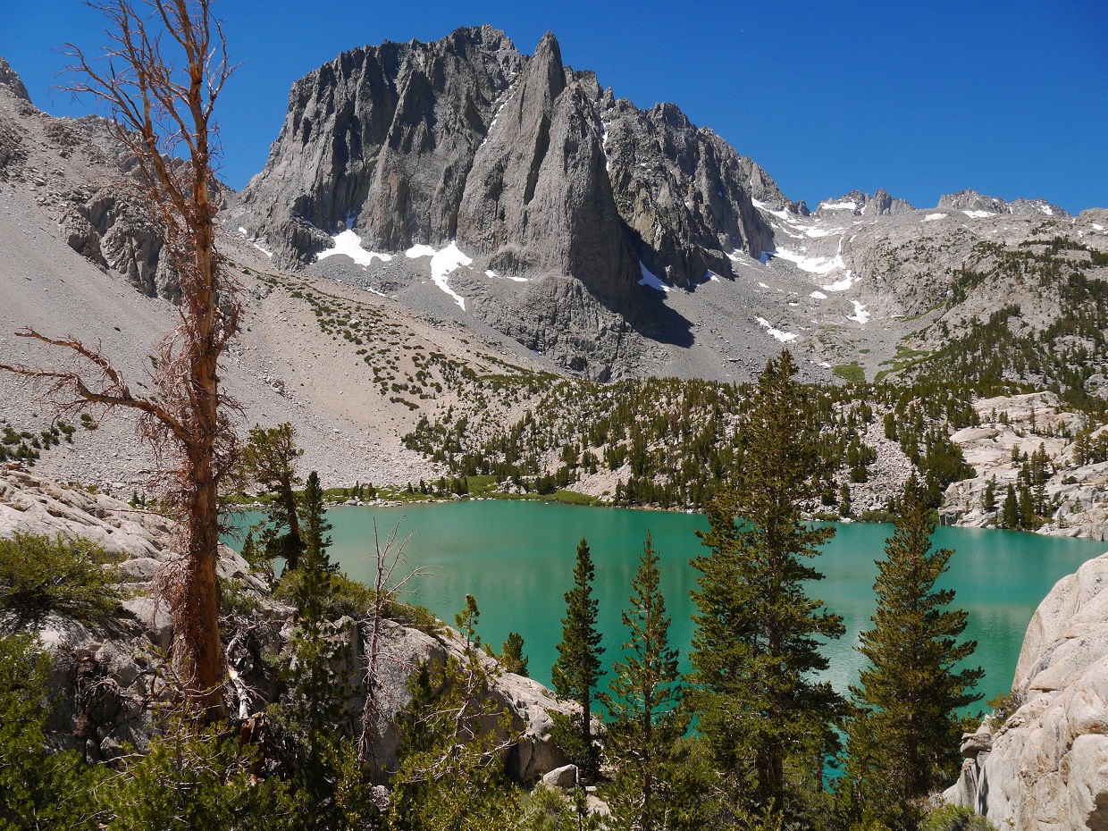
From camp I headed in a general NNW direction across several tedious moraine fields and ledge systems to the outlet of Sam Mack Lake, which lay at the base of Robinson's east ridge.


looking towards Robinson from Sam Mack Lake


Sam Mack Lake


The east ridge of Robinson was your typical Sierra slog. It contained long bouldery slopes interspersed with short class 3 sections. I remained mainly on the left side of the ridge which looked to contain more solid rock. The last few hundred feet contained a short and exposed section of class 3 ridge.


summit views:

Palisade Glacier


Thunderbolt to Polenomium closeup


Mt. Agassiz


Sam Mack Lake and the north fork of Big Pine Creek


For the descent, I headed down a large gully which lay in between the east ridge and northeast ridge. The gully was a horrible screeish mess, and I wish that I could've just taken the east ridge back down.

looking down the gully


back at Sam Mack Lake


To get to Sam Mack Meadow from Sam Mack Lake, I descended a short distance south to a large creek drainage gully, and followed it downstream until it joined up with the meadow. At some point, this gully narrowed and was covered with unstable snow bridges with the creek flowing underneath. I stuck to the rocks, even when it meant downclimbing class 3 boulders with the creek flowing right on top of me. I emerged at Sam Mack Meadow sopping wet and feeling thoroughly refreshed.

Sam Mack Meadow seen from the top of the drainage


looking back at the drainage from Sam Mack Meadow


After a bit of lingering and snacking in the meadow, I headed down the North Fork Trail to the trailhead.

views from the hike out


Final Stats
23.9 miles
8,860 ft gain/loss


Weather Forecasts
Trailhead
Sam Mack Meadow
Palisade Glacier, Mt. Robinson
Mt. Sill

Peakbagger Pages
Mt. Sill
Mt. Robinson

Summitpost Pages
Swiss Arete
Mt. Sill
Mt. Robinson

Other
Swiss Arete (Mountain Project)
Swiss Arete (Supertopo)
High Sierra Topix message board

Muir Peak, Mt. Rainier, Anvil Rock, The Sugarloaf, McClure Rock

back to home page

June 15-17, 2014
At 14,411 ft of elevation and containing 13,222 ft of clean topographic prominence, Mt. Rainier is the highest mountain in the Cascade range and the 21st most prominent mountain in the world. With its 26 major glaciers, Mt. Rainier is also the most glaciated mountain in the southern half of North America. The mountain offers much in terms of mountaineering, containing anything from couple day walk-ups to multi day ice climbs.

The Disappointment Cleaver route (see map) is the easiest and most popular route up the mountain, with a total length of 14.8 miles and elevation gain of 9,600 ft. Most of it is class 1, with a few scattered class 2 sections. The main difficulties of this route involve weather, crevasses, and possible avalanches. Start from the visitor center parking lot in Paradise (5,430 ft). Take the well-traveled Skyline Trail to the base of the Muir Snowfield (7,200 ft, 0.1 mi WNW of McClure Rock), and continue up the snowfield to Camp Muir (10,100 ft). The total distance from the trailhead to Camp Muir is roughly 4.1 miles. From Camp Muir, head NNW across the Cowlitz Glacier to Cathedral Gap (10,710 ft)- the lower of two prominent gaps visible from camp (the upper one is known as Cadaver Gap). The last few hundred feet before Cathedral gap may contain somewhat loose scree in late spring and summer. From Cathedral Gap, Disappointment Cleaver should be visible as the long sliver of exposed rock to the northwest. Head a short distance WNW across the heavily crevassed Ingraham Glacier to Ingraham Flats (11,050 ft)- the second most popular campsite on the route. From there, head north to a "soft spot" just above the base of Disappointment Cleaver, then up onto the cleaver itself. The bottom half of the cleaver may contain fixed ropes during high season (typically from June to August). Once on the cleaver (which may contain loose rock during summer months), follow it to its western end (12,370 ft), then continue in a general NNW direction up the Emmons Glacier, ascending to the southeast crater rim (14,200 ft). Walk northwest across the crater to the true summit (14,411 ft).

During late spring and summer months, there will likely be a flagged snow trail extending from where the snow starts all the way up to the summit. Although this trail will mitigate the need for much routefinding, please do not completely rely on it! The weather can change at any moment and visibility can drop to a few feet, or a summer snowstorm could cover up the trail completely. Maps and GPS can be very helpful in these situations.

PeakElevationTopographic ProminenceSummit Coordinates (lat/lon)
Muir Peak10,188 ft98 ft46.835272, -121.730962
Mt. Rainier14,411 ft13,222 ft46.852947, -121.760424
Anvil Rock9,584 ft44 ft46.829641, -121.725631
The Sugarloaf7,820 ft31 ft46.813703, -121.721735
McClure Rock7,385 ft20 ft46.808642, -121.722887

Getting to the trailhead: Take the southwest entrance to the large parking lot at the Paradise visitor center
Trailhead coordinates: 46.786351, -121.736411

Craig, Sung, Mairi, Jeff, Eric, Marian, Mihai, and I headed up towards Camp Muir from the Paradise trailhead on Sunday morning at 8:30 am. There was a thick layer of snow down to the parking lot, and we lightly postholed up a well defined snow trail from the start.

Paradise trailhead


As we hit the Muir Snowfield, the wind picked up, the clouds darkened, and it began to snow. Visibility dropped to 20 ft at times. Everything around us was pure white. It was like walking in a dream.


We reached Camp Muir at around 1:30 pm, and promptly began checking the place out. Since the Muir Hut was still empty, most of the group opted to camp in there. For the next few hours, we sat around chatting and melting snow for drinking water. As more people arrived and the hut crowded up, Marian and I decided to camp outside to avoid all the hustle and bustle.

view of the east side of Camp Muir (west side contains guide service & ranger cabins)


At around 6pm the clouds cleared, revealing the upper mountain.


Since it was still pretty early, I decided to head northwest up the Cowlitz Cleaver and check out a rock formation labeled as "Beehive" on the topo map. The hike up to the base of the Beehive was easy, containing class 2 semi-loose rock and small portions of the Cowlitz Glacier.


views from ascent


After checking all sides of the Beehive, I found its southern side to contain the easiest route up. The climbing was all class 4 until a tight class 5 chimney ~8 ft below the highpoint. I remained there for some minutes, debating whether or not I should go for it, and eventually decided not to risk it. The rock was very loose and difficult to trust, and a fall would likely be fatal.


views from descent


There was still plenty of daylight remaining as I reached camp, so I headed east to tag Muir Peak- a small unofficially named peaklet located a few minutes away. From camp, two bumps appeared to the east. The further one was Muir Peak. The closer one contained a memorial to Jaine Diepenbrock, who died in an avalanche below Cadaver Gap on March 4, 1979.


Muir Peak


After tagging Muir Peak, I headed back to camp and crawled into bed, hoping to get at least a few hours of sleep before the 12am wake up time.

Before I knew it, the entire camp was filled with headlamps and voices, and I stumbled out of the tent into crisp early morning air. There were roughly 30 people outside getting ready. By 1:40 am, everyone (including us) were off. Our group headed up in two rope teams of four, ascending at a very slow and steady pace.

As we reached Cathedral Gap, we could see the dark mass of Disappointment Cleaver in the distance and a long string of headlamps heading across Ingraham Flats. The first half of the cleaver contained fixed lines which were not necessary given the light terrain, but were put there by previous guide services in order to account for the lowest common denominator among their clients. As we reached the upper half of Disappointment Clever, we were repeatedly blasted with strong gusts of wind from the northeast. Out came the balaclavas. A few moments later, I was very glad to finally see the tiny speck of sun make its way over the horizon.

top of Disappointment Cleaver


sunrise from ~12,400 ft


Gibraltar Rock and Mt. Adams


As we continued up the Emmons Glacier, the wind continued to scream. At times, small lenticular clouds formed around us. The climbing itself wasnt too exciting- just one step in front of the other. The views, however, were pretty amazing.


arriving at the southeast crater rim


Craig approaching the summit


We all stood around at the summit for a short moment, celebrating and taking a few quick group photos. After a few minutes, we headed back down to get out of the wind.

team on the summit (photo by Mihai Giurgiulescu)


summit panorama (photo by Mihai Giurgiulescu)


view south from summit


northwest (Liberty Cap is the highpoint)


northeast


east


views from descent


By early afternoon, everyone had gotten back to Camp Muir. A light steady snow had began to fall. Most people in the group did not want to hike back down that day, so we spent the rest of the day hanging around at camp.

We woke up the next morning to find roughly an foot of extra snow on the ground. Several groups of climbers could be seen trudging back to camp from Cathedral Gap, having turned around due to heightened avalanche danger. It did not seem like anyone had made it to the summit.

good morning!


small avalanche on Gibraltar Rock


the false summit of Muir Peak


By 8am, everyone was packed up and heading down from camp. The new snow made for some nice and easy heel plunging.


On the way down, we took a slight detour to tag Anvil Rock- a rocky outcropping located 0.5 mi SE of Camp Muir. The views from this seemingly insignificant feature were pretty stunning.


Nisqually Glacier icefall


looking back at Anvil Rock


Below Anvil Rock were two more features: The Sugarloaf and McClure Rock. Both of them were located a short distance east of the Muir Snowfield and contained easy class 2 terrain at most.


summit of The Sugarloaf


view of Rainier


McClure Rock


another view of Rainier


summit of McClure Rock


looking towards Cowlitz Rocks


battered benchmark


more views


After McClure Rock, we headed towards the trailhead, plunging into a sheet of thick misty clouds.


Final Stats
16.6 miles
11,060 ft gain/loss


Disappointment Cleaver route (by itself)
14.8 miles
9,600 ft gain/loss


Weather Forecasts
Trailhead
6,560 ft
Camp Muir
summit area (NWS forecast)
summit area (Mountainforecast)

Peakbagger Pages
Muir Peak
Mt. Rainier
Anvil Rock
The Sugarloaf (note: The coordinates and location of this peak on the provided map are incorrect)
McClure Rock

Summitpost Pages
Muir Peak
Mt. Rainier

Other
Mt. Rainier National Park
Mt. Rainier webcams
Cascade Climbers