
Warning: The following route passes through sections of private property which are rated up to S5 by the Sneak Climbing Section or ISC-F5C3T4 on the ISC system. Keep in mind that this rating is subject to change at any time and without notice. If you are uncomfortable with trespassing, please do not attempt this route.
February 1, 2014
Sandwiched between San Vicente Reservoir and El Capitan Reservoir in Eastern San Diego County are a small group of chaparral covered mountains, the highest of which is known as El Cajon Mountain. The area offers a variety of hiking-related activities anywhere from trail running to peakbagging to multi-pitch trad climbing. Even though I lived less than 30 minutes from the area, I had never really got around to exploring it. So on a whim, I printed out a few Topo maps, marked up some peaks, and headed towards El Cajon one Saturday morning.
My plan (see map) was to start from the El Cajon Mountain Trailhead and walk south along Wildcat Canyon Road, then utilize a series of dirt roads, passing through areas of private property to reach an unnamed peak 0.86 miles SSE of the trailhead. A few sources indicated that this peak (and another unnamed peak located 0.78 miles NNE of it) were locally referred to as the "Pata Peaks." To lessen the confusion between the two peaks, I will refer to them as "Pata Peak South" and "Pata Peak North." After summiting Pata Peak North, I would head onto the main El Cajon Mountain Trail and start making my way east towards El Cajon Mountain, passing by and summiting both Silverdome and an unnamed peak which I had dubbed "Silverdome II" along the way (This peak is incorrectly labeled as Silverdome on Google Earth and MyTopo). These were both easy climbs, with each adding up to half a mile roundtrip from the trail. Just before reaching the summit of El Cajon Mountain, I would leave the trail and bushwhack my way northeast to the summit of Rock Mountain. Though labeled prominently on most Topo maps, I had been able to locate only a 2-sentence trip report on it. To the east of Rock Mountain was Westside Road, a north-south running truck trail which looked old and in disrepair, and was possibly on private property. After bushwhacking to Westside Road from Rock Mountain, I would follow the road north for several miles, bag San Vicente Mountain and a smaller peak to the east of San Vicente (which I dubbed "Little Vicente"), then head back along Westside Road to a spot directly east of the summit of El Cajon Mountain. From there, I would bushwhack my way up El Cajon Mountain's east face to the summit, then follow the El Cajon Mountain Trail back to the trailhead. It seemed like a pretty full day.
| Peak | Elevation | Topographic Prominence | Summit Coordinates (lat/lon) |
|---|---|---|---|
| Pata Peak South | 2,140 ft | 440 ft | 32.90074, -116.880584 |
| Pata Peak North | 2,260 ft | 360 ft | 32.910883, -116.874597 |
| Silverdome | 2,388 ft | 488 ft | 32.914961, -116.864309 |
| "Silverdome II" | 3,177 ft | 317 ft | 32.917476, -116.844127 |
| Rock Mountain | 3,299 ft | 439 ft | 32.93242, -116.811285 |
| San Vicente Mountain | 2,855 ft | 755 ft | 32.968355, -116.811748 |
| "Little Vicente" | 2,522 ft | 342 ft | 32.970057, -116.801598 |
| El Cajon Mountain | 3,675 ft | 1,975 ft | 32.914778, -116.820141 |
Getting to the trailhead: To get to the official El Cajon Mountain Trailhead, follow the directions from Summitpost to the parking lot off Wildcat Canyon Rd (more specifically, at the junction of Wildcat Canyon Rd and Blue Sky Ranch Rd aka. Shenma Rd). Because the gates to this parking lot are locked every day at 4:30 pm, I parked outside of it along the road.
Trailhead coordinates (lat/lon): 32.912882, -116.884525
I began hiking from the trailhead (1,550 ft) at 6:15 am, heading south along Wildcat Canyon Road. About half a mile from the trailhead, I located a dirt road branching off left that headed towards Pata Peak South.
beginning of dirt road to Pata Peak South

After ~0.4 miles, the dirt road intersected with another road (a spot which I will refer to as the "first intersection"), at which I split off towards the right. I continued a short distance up this new road, which dead ended above two dirt lots. Seeing on the Topo that Pata Peak South was almost directly to the south of where I stood, I began bushwhacking up the slope. About 10 minutes later, I intersected a dirt road which switchbacked up the slope, and followed it a short distance until it dead ended shortly before the summit of Pata Peak South. The summit itself was visible from here and was a short bushwhack away.
view from second dead end

I remained for a while on the summit of Pata Peak South, taking photos of the sunrise and checking out its two summit blocks which both vied for the status of highpoint. The northern block was an easy class 3 feature, and the southern block was a 15 ft class 5 boulder. I climbed the class 3 block, but balked 4 feet below the top of the class 5 block due to its smooth slippery surface and lack of confidence in my free soloing skills. If I ever find out that the class 5 block is indeed the higher one, Im gonna go back there, this time with a rope and harness.
views from Pata Peak South


heading down Pata Peak South

On the way down from Pata Peak South, I continued down the dirt road past the intersection I had made with it by bushwhacking. It turned out that I could have avoided the bushwhacking by turning left on a small side road ~150 ft after the first intersection.
Pata Peak South satellite overview

After getting back to the first intersection, I turned right and headed ~150 ft down a dirt road to where a small trail branched off towards the left with a sign that read "El Capitan Trail." This trail would head around the eastern side of Pata Peak North. I followed the trail for ~0.4 miles to a spot where it contoured just above a prominent saddle at 2,040 ft, left the trail, and bushwhacked the short distance to the summit of Pata Peak North. The summit area contained great views towards El Cajon Mountain and the two Silverdomes.
view towards Pata Peak North from Pata Peak South

trail branches off

views from Pata Peak North


Back on the trail, I headed north for less than a quarter mile and intersected the El Cajon Mountain Trail. The "trail" was really an old dirt road. It was definitely a popular hike, as evidenced by the several groups of dayhikers and trail runners who were on it.
El Cajon Mountain Trail

After hiking half a mile on the El Cajon Mountain Trail, I came to the base of Silverdome.

The southwest side of Silverdome was comprised of a series of grass-covered slabs, making for a quick and easy ascent. The summit area was a small bushy plateau containing a small summit block which was marked with a cairn.
views from Silverdome


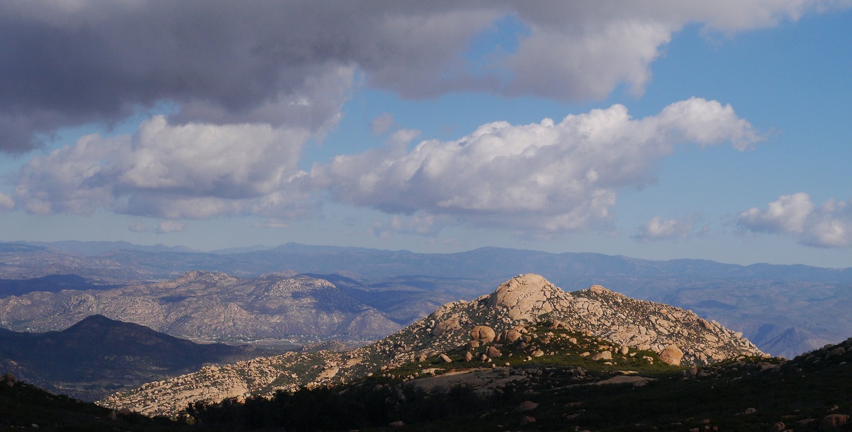
Next up was Silverdome II. From the Silverdome turnoff, I followed the trail for 2 miles to the southeast side of Silverdome II to where a trail branched off to the left. This trail headed northwest for a tenth of a mile, then ended at an old mine.
Silverdome II seen from the El Cajon Mountain Trail

Somewhere along the trail, I ran across a stop sign warning hikers to turn back by 12:30 pm. This was somewhat strange and amusing. I would also like some advice on how to "attemp" a peak. Is this some new type of peakbagging fad? All I can say is that in the end, I still respected the first part of the sign and did not in any way "attemp" the summit of El Cajon Mountain at sunset later that day.

views from trail


old mine

From the mine, it was a short bushwhack northwest to the summit of Silverdome II. About halfway up, there was a very short band of class 3 rock. Upon reaching the summit, I ran into two trail runners who had ascended from the southwest and mentioned horrible bushwhacking.
views from ascent


summit


After eating a quick energy bar at the summit and taking in the views, I headed back to the trail and hiked 1.5 miles to a 4-way junction where a small trail split off and headed southeast towards the summit of El Cajon Mountain. I headed up this trail for less than a quarter mile, then left the trail and began cross countrying northeast for the arduous bushwhack to Rock Mountain.
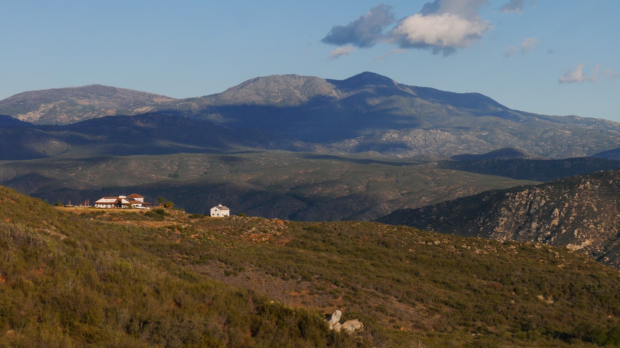
San Vicente Mountain seen from the trail

Rock Mountain seen from the start of the bushwhack
Immediately after leaving the trail, I found myself immersed in waist deep chaparral. As I continued northeastward, the brush increased, sometimes blocking all visibility of surrounding terrain. The brush was worst in the gullies, rising up to 15 ft high. Beginning at the halfway point between leaving the trail and the summit of Rock Mountain, the brush thinned some and made for more pleasant travel. The last few hundred feet to the summit of Rock Mountain involved some fun class 3 cracked slabs. It seemed to be a great area for some technical rock climbing if one was willing to go through all the bushwhacking required to get there.


summit views


After a lunch break on Rock Mountain, I began descending east towards Westside Road, which was over 1,000 vertical feet below. Branching southeast from the summit of Rock Mountain was a boulder strewn ridge which I descended on until it merged with a slope. The remaining slope to Westside Road contained some light to moderate bushwhacking.
looking southeast towards the ridge

looking back at the summit blocks of Rock Mountain

views from descent


Contrary to what I had imagined it to be, Westside Road was in pretty good shape and looked recently traveled. I had no idea whether or not I was on private property. A few distant gunshots rang out from what seemed to be the northwest. I headed north, following the road towards San Vicente Mountain.

looking down into the San Diego River Gorge

After about 2 miles on the road, my suspicions of private property were confirmed when I crossed over a gate. Looks like the dog had been on vacation today.

As I reached a point on the road directly southeast of the summit of Little Vicente (~3.5 miles after intersecting the road), an overgrown trail branched off to the left. This was the turnoff for both San Vicente Mountain and Little Vicente.

A little more than a quarter mile after the turnoff, the trail intersected a series of loopy dirt roads. This intersection was marked by a small gate.

Recalling the satellites images I had looked at earlier, I headed in a general western direction, staying on the northernmost of the loopy dirt roads until a spot directly north of a small pond, at which I cross countryed west for a few hundred feet to intersect a north-south running trail.

After a few minutes of heading north on the north-south running trail, I left the trail and cross countryed northwest up a moderately brushy slope to the summit of San Vicente Mountain.


views from summit


The hike east over to Little Vicente was straightforward and relatively uneventful.

views from Little Vicente summit


From the summit of Little Vicente, Westside road was a short distance away to the east, separated by slopes that were not too brushy. I headed back to Westside, then started the 5 mile walk along the road to the base of El Cajon Mountain's east face.
scenery along Westside Road


Upon reaching the base of El Cajon Mountain's east face, I picked one of several ascent lines along the face that looked to contain manageable bushwhacking. As it turned out, the brush was not nearly as bad as the stuff encountered on my way to Rock Mountain earlier that day.
my ascent line

I topped out on the summit of El Cajon Mountain shortly before sunset, and sat there for a few moments enjoying the nice orange lighting and the brilliantly lit profile of Rock Mountain.


As the sun dipped below the horizon, I began making my way down the El Cajon Mountain Trail towards the trailhead, arriving back shortly before 7:30 pm.
Final Stats
28 miles
10,160 ft gain/loss

Weather Forecasts
Trailhead
Pata Peaks, Silverdomes area
El Cajon Mountain, Rock Mountain
San Vicente Mountain area
Peakbagger Pages
Pata Peak South
Pata Peak North
Silverdome
Silverdome II
Rock Mountain
San Vicente Mountain
Little Vicente
El Cajon Mountain
Summitpost Pages
El Cajon Mountain
Other
Cleveland National Forest
I've thoroughly enjoyed visiting this page more than once. It's amazing how much you put into it, and very much appreciated. In the 1960's as a teen I climbed El Cajon/El Cap' Mountain 7 times, bushwacking from El Monte Valley, directly soutn of the park. I know of no one else to climb this route. Not to be confused with going up 'the face'/arete/plough.
ReplyDeleteI've thoroughly enjoyed visiting this page more than once. It's amazing how much you put into it, and very much appreciated. In the 1960's as a teen I climbed El Cajon/El Cap' Mountain 7 times, bushwacking from El Monte Valley, directly soutn of the park. I know of no one else to climb this route. Not to be confused with going up 'the face'/arete/plough.
ReplyDeleteMay I ask where you got the names of Pata Peaks and "Silverdome 2"? I've never heard of Pata Peaks being named and I've only heard of "Silverdome 2" being called Engert Peak
ReplyDelete