
June 26-27, 2013
The Dinner Plate Traverse consists of climbing five peaks that border the highest named lake in California in a clockwise or counterclockwise direction. They consist of: Mt. Russell, Mt. Morgenson, Tunnabora Peak, The Cleaver, and Mt. Carillon. Each one of these peaks has an elevation of over 13,000 ft. Mt. Russell, the highest peak in the group, has an elevation of 14,088 ft. The smooth, bowl shaped nature of the valley which these peaks surround has led some to refer to this route as the "Dinner Plate Traverse."
| Peak | Elevation | Topographic Prominence | Summit Coordinates (lat/lon) |
|---|---|---|---|
| Thor Peak | 12,306 ft | 266 ft | 36.576741, -118.265639 |
| Mt. Russell | 14,088 ft | 1,129 ft | 36.590085, -118.290796 |
| Mt. Morgenson | 13,927 ft | 312 ft | 36.591603, -118.299852 |
| Tunnabora Peak | 13,563 ft | 604 ft | 36.605085, -118.282265 |
| The Cleaver | 13,383 ft | 359 ft | 36.597453, -118.27474 |
| Mt. Carillon | 13,553 ft | 262 ft | 36.592408, -118.277916 |
Our plan was to start the hike from Whitney Portal Trailhead, hiking a mile up the main Whitney trail and splitting off at the north fork turnoff, then heading over to either Lower or Upper Boy Scout Lake to set up camp. If there was time, we would climb nearby Thor Peak (12,306 ft). The next morning, we would keep hiking up the canyon, splitting off at the Rockwell Variation which terminates at Russell-Carillon Pass. From there, we would continue up Mt. Russell (14,088 ft) from its class 2-3 East Ridge (aka. East Arete). We were a little divided on how to go after Russell. Our next peak would be Mt. Morgenson (13,927 ft). The traverse on the ridge between Russell and Morgenson was reportedly exposed class 4-5. In the one trip report we had read, the climbers had gone from Morgenson up to Russell on sketchy terrain. We would have to go down from Russell to Morgenson. After discussing this for a little bit, we scrapped the idea of traversing to Morgenson along the ridge. This would mean dropping down from Russell and climbing Morgenson separately. I had noticed on Summitpost that there was a class 3 ridge descending the north side of Russell. The ridge terminated at a spot 0.5 linear miles east of Mt. Morgenson's base. We had origionally planned to descend back down Russell's East Ridge to Russell-Carillon Pass, drop down into the bowl containing Lake Tulainyo, and traverse to Morgenson from there. Russell-Carillon Pass would leave us 0.95 linear miles east of Mt. Morgenson's base. We were a little hesitant about the north ridge because none of us had read any reports of people descending it, but were open to checking it out if it looked good.
From Morgenson, it was reportedly an easy class 2 walk up to Tunnabora Peak (13,563 ft), and then on to The Cleaver (13,383 ft) which involved some strong class 3 and possibly low class 4 climbing. Our last peak would be Mt. Carillon (13,553 ft), which would be attained by ascending class 2-3 terrain back up the Russell-Carillon Pass and climbing up Carillon's class 2 west ridge. Our descent route was most likely going to be a sandy slope which starts south below Mt. Carillon and terminates at Clyde Meadow.
Getting to the trailhead: From Lone Pine off of Hwy 395, head west on Whitney Portal Rd for 13 miles to a parking area.
Trailhead coordinates (lat/lon): 36.586907, -118.240020
Both of us were very excited about the upcoming climb as we pulled into Whitney Trailhead (8,300 ft) on Wednesday afternoon. None of us had ever been through north fork before, so all except the first mile of Whitney trail was going to be new to us. We quickly packed our bags and made way up the Whitney trail by 3:20 pm.
Whitney Trailhead

There was an expansive view of Thor Peak and North Fork about a quarter mile in. The main Whitney Trail continues up South Fork.

The turnoff for North Fork (8,700 ft) was marked with a sign. There was also a stream flowing right next to it, which we gladly soaked our faces in. As we proceeded up the North Fork trail, I could tell that the trail was not maintained, but existed because of popularity. It was very easy to follow. The trail crossed a stream a total of 2 times before reaching the Ebersbacher ledges at 9,550 ft.
Ebersbacher Ledges seen just before second stream crossing

Almost immediately after the second stream crossing, the trail ended at a rock wall. There was a pine tree at the base of the ledges, and aiming for that tree was the key to getting onto them. Once at the tree, we followed a ledge walk-path until it ended, then turned left onto another walk-path and followed that until it ended. And that was it, in all about 300 ft of vertical gain. The ledges were mainly class 2 with a few low class 3 moves. Even though it was exposed in some spots, there was plenty of room to stand on. There were no areas with any less than 2 ft of foot room at any given time.
entrance onto ledges (pine tree circled in image above is on the right side of the image below)


Once above the ledges, it was a short walk on a use trail to Lower Boy Scout Lake (10,300 ft).

The "lake"

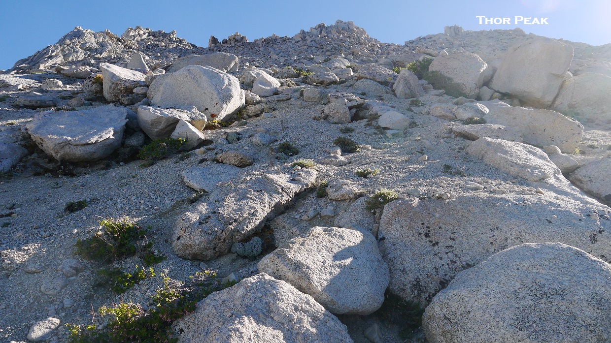
It was still early in the day at 4:40 pm, so we decided to go climb Thor Peak (12,306 ft). Thor Peak is not part of the Dinner Plate Traverse, but it was still there to climb. We walked around to the south side of Lower Boy Scout Lake and attained a view of our route up Thor.

The first 1,200 ft of climbing consisted of loose scree and talus, stuff that made me empty out my shoes every 15 minutes or so. Once above the scree gully, we found ourselves on a gently sloping plateau. This slope was very sandy at first, but gradually because more solid. Pretty soon we were walking on nice solid rock.
looking up the plateau (true summit labeled)
Once on the plateau, we were not very sure of which bump to aim for, so we aimed for the seemingly highest one. Once on top of that bump, we found that the true summit was one over to its right.
Thor's true summit with Mt. Whitney in the background


Tommey on (or above) Thor's summit

The descent off Thor was total foot candy. Even though I still had to empty out my shoes of sand, it was nice, soft, heel plunging all the way back down the mountain. It took about 30 minutes to descend 2,000 ft back to Lower Boy Scout Lake at a relaxing pace. There had been no climbing surpassing class 2 on our route up and down Thor Peak, except maybe an easy class 3 move on the summit blocks.
views on descent


Back at Lower Boy Scout Lake, we found ourselves being eaten alive by mosquitoes, and decided to head further up above treeline to Upper Boy Scout Lake (11,300 ft). It was around 7:30 pm, so there was plenty of daylight left to make the climb.
start of the route from Lower Boy Scout Lake

We contoured around the south side of Lower Boy Scout Lake, where the use trail vanished and turned into boulder hopping. Fragments of trail started appearing again at 10,700 ft. At this point, the trail didn't matter anymore. All terrain was easy and gentle. The main canyon split in two, and we took the right fork towards Upper Boy Scout Lake (Left fork goes to Iceberg Lake which is used for Whitney's Mountaineer's Route). The terrain became increasingly scenic. We found ourselves walking up several large low-angle slabs with rivulets of water flowing on them. The water made some of the slabs slippery, so we exercised caution stepping on certain polished sections.

The sky was just beginning to darken as Upper Boy Scout Lake came into view. It looked like a mere puddle from a distance, but turned out to be a fairly good-sized body of water closer up. There were several groups camping there already. The majority of them were planning to head up to Russell the next day.
Several good campsites could be found scattered along the southern side of Upper Boy Scout Lake. The ground was nice and sandy, padded down with use. Several areas had been protected with wind shelters. Tommey and I picked a vacant shelter and started setting up camp. Immediately after we stopped, I noticed that there were several mosquitoes buzzing around. There were considerably less mosquitoes here than at Lower Boy Scout Lake, but still enough that I attained a bite every 20 minutes or so. I wasn't too surprised that they were this far above treeline. After all, the weather was still pretty warm up here at around 65F.
Throughout the night, we tossed and turned in our bivys with mosquitoes buzzing here and there. I was glad to get up in the morning and start moving around.
sunrise at Upper Boy Scout Lake


Having cached our overnight gear at Upper Boy Scout Lake (10,300 ft), we took daypacks and followed the main canyon up to the start of the class 2-3 Rockwell Variation (12,250 ft). This spot is evident when rock walls to the north give way to a series of ledges.
route from Upper Boy Scout Lake

start of Rockwell Variation


Once above the ledges (12,500 ft), the ground suddenly turned to mush. For every three steps we took, two were lost.

We heaved and groaned up the gully with each step, aiming for any mildly solid rock that could be seen, only to have it flake away as well. Those rocks in the RockWELL variation were certainly not well. A more fitting name for this route would've been "Russell's Diarrhea."
The rock quality started getting considerably better for the last 300 ft of gully. There was some nice solid class 3 rock to the left which could be climbed in order to avoid class 2 scree to the right. Once above the chute, we found ourselves at 13,450 ft, about 0.1 mile west of Russell-Carillon Pass.
view east from top of Rockwell Variation

Continuing west up Russell's East Ridge, we found much more enjoyable climbing. The rock was very solid, and there were great views all around.

Polemonium (Sky Pilot Flower)

Russell's East Ridge consisted of mainly class 2 climbing. There were a few easy class 3 moves here and there, all on very firm rock. There was always the option of dropping onto some class 2-3 ledges to the right if the top of the ridge became too exposed. There were a few areas where we had no choice but to top out on the ridge, but those areas gave us ample foot room at any given place.


Russell consists of two highpoints: East and West summits. The West Summit is higher. This involves climbing up and over the East Summit and traversing across a ridge to the true highpoint.
view from East Summit


traversing along fun class 2-3 terrain to West Summit (East Summit in background)

Russell's summit (14,088 ft) consisted of several large, flat blocks. It seemed as though someone had carved out a large platform for hikers to converge on.
expansive views from Mt. Russell

Wallace Lake and Mt. Williamson's impressive South Face

Lone Pine Peak (highest point in picture) and Upper Boy Scout Lake

west towards Morgenson

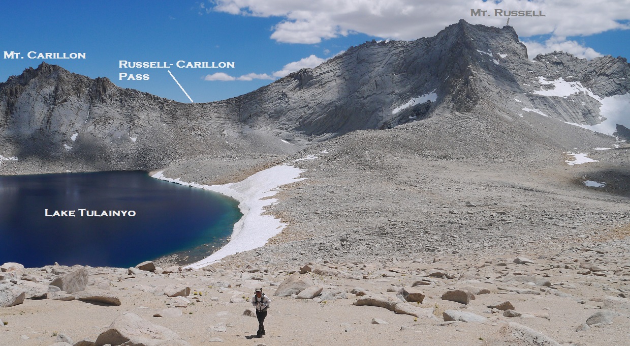
We had origionally thought of maybe traversing the ridge between Russell and Morgenson, but upon looking at it's sheer exposure and knife-edged nature, decided to descend Russell via its class 3 North Ridge and climb Morgenson from its southeast slopes.
Russell's North Ridge starts at the East Summit, continuing down northeastward into a large basin containing Lake Tulainyo.
starting to descend the North Ridge

The descent was relatively solid and highly enjoyable, consisting of large, blocky rocks and ledgy terrain. As long as we stayed to the left (west) side of the ridge, we ran into nothing more difficult than class 3 climbing.

As soon as the ridge started flattening out (~13,500 ft), we descended sharply west off the ridge on some sandy ledges and headed towards a small tarn (13,000 ft) to fill up on water.

At the tarn, I quickly gobbled down an energy bar, not wanting to loose all my energy somewhere along the way. Tommey drank some of his "solution," which consisted of a granola bar and packet of energy gel he had dropped into a bottle of water, now dissolved into an oatmeal-like substance.
Morgenson's southeast slope turned out to be easy class 2 climbing. The rock consisted of broken semi-loose talus.
contemplating life on the southeast slope

The last 100 ft of climbing involved a short traverse on a blocky ridge that led to the summit. There was a register, an ammo box painted gold, sitting below the highest block (13,927 ft). I climbed up to it, peered over onto the other side, and was blown away by the scenery. The main thing that stood out about this peak was its incredible summit views. An endless array of lakes, valleys, peaks, and sheer drop offs stretched out in all directions. The register indicated that this peak was rarely visited (only a few times a year). It is truly one of the jewels of the Sierra.


After 20 minutes on the summit, we descended back down the southeast slopes and began walking towards Tunnabora Peak on the other side of the basin. I had expected this portion of the Dinner Plate Traverse to be long and uneventful, but it turned out otherwise. The basin was very expansive, giving us great views of peaks all around us. There were several patches of Hulsea Algida (Alpine Gold) growing here and there, making splothes of yellow against the surrounding gray mountains.
Hulsea Algida and Mt. Russell

Tunnabora Peak looked like it was easy climbing from all possible routes on this side, so we made a beeline for the summit.

starting up Tunnabora Peak's north slopes
We had a choice of either boulder hopping or sand slogging up this slope. Tommey chose sand, and I chose boulders. The climb itself was repetitious and uneventful. But this peak, much like Mt. Morgenson, had surprisingly good views waiting for us at the top. The entire George Creek area lay below us to the north.


Lone Pine Peak

Tunnabora Pinnacles

whats left on this dinner plate

Russell & Morgenson

Descending Tunnabora felt very nice on our feet. About 200 ft below the summit, the rocks gave way to deep, soft sand which we plunged our heels into. Alpine wildflowers bloomed here and there.


north shore of Lake Tulainyo (12,800 ft)


Our next objective, The Cleaver, rose up to the southeast. This was supposed to be a very short and fun climb. We reached the base of it by contouring clockwise around Lake Tulainyo on soft sandy beaches.
base of The Cleaver

The climb started with a boulder hop up to 13,100 ft where we accessed some class 3 ledges to the right (south). These ledges were solid and the climbing fun. We climbed from one ledge system up to the next, continuing south. Upon topping out at a ridge, we turned left (north) and gradually contoured up, staying just below the ridge. The summit (13,383 ft) was very obvious at the end of the ridge. We had a fun time opening the summit register, which was a jar with the lid tightly clamped on. Tommey succeeded in opening it by steadily tapping the lid against a rock.
views while ascending


summit views


looking northwest towards Tunnabora

From The Cleaver, we retraced our steps down the ledges, then continued contouring clockwise around Lake Tulainyo upon reaching Talus.
Tunnabora Peak from Lake Tulainyo's south shores

Unlike the sandy beaches along Lake Tulainyo between Tunnabora Peak and The Cleaver, the terrain after The Cleaver contained several large boulders. These boulders were in solid condition.
looking back at The Cleaver

We started climbing up again once we saw Russell-Carillon Pass looming closer. Since the last item on the dinner plate: Mt. Carillon, was towards the left (east), we were able to climb class 2-3 rock to a spot slightly above and to the east of Russell-Carillon Pass.


From Russell-Carillon Pass (13,280 ft), it was a class 2 walk up to the summit of Mt. Carillon (13,553 ft). We followed the west ridge east, sticking to its right (south) side. There was a low class 3 move required for the summit block. Great views spanned out in all directions. It was an awesome finish to the Dinner Plate Traverse.

There were magnificent views of Mt. Russell's East Ridge from Carillon. Its sheer verticalness made it look like a very technical climb.


Lake Tulainyo and friends


Mt. Whitney

To get back down to Upper Boy Scout Lake, we dropped straight down to the South from Carillon onto a sandy flat. Once on the flat, we headed southeast to a dropoff. The top of the dropoff (12,800 ft) was marked by a big cairn, where we started descending towards Clyde Meadow. This descent was very fast and pleasant. Several areas of deep sand had us heel-plunging into the soft ground, coasting down the slope. A use trail was already blazed into the sand, and we followed it all the way down. I would recommend this route as an ascent and descent rather than the Rockwell Variation.
view of our descent route (green) and Rockwell Variation from Thor Peak

We got back down in no time and headed back to camp, packing quickly in the midst of nagging mosquitoes. The descent back to the trailhead was straightforward, following the main canyon back down to Lower Boy Scout Lake, Ebersbacher Ledges, and main Whitney Trail, eventually reaching the trailhead at sunset.
sunset glow on Inyo Mountains

Final Stats
16.4 miles
12,400 ft gain/loss
(note: green circles mark summit locations and do not mean "unmaintained trail")

Dinner Plate Traverse: by itself & ideal route
14.6 miles
10,100 ft gain/loss
(note: green circles mark summit locations and do not mean "unmaintained trail")

Weather Forecasts
Trailhead
Thor Peak/Upper Boy Scout Lake area
Russell, Morgenson, Tunnabora, Cleaver, Carillon (Mt. Russell has an elevation of 14,088 ft. Keep in mind that this forecast is for 13,107 ft.)
Peakbagger Pages
Thor Peak
Mt. Russell
Mt. Morgenson
Tunnabora Peak
The Cleaver
Mt. Carillon
Summitpost Pages
Thor Peak
Mt. Russell main page
Mt. Russell East Ridge
Mt. Russell North Ridge
Tunnabora Peak
The Cleaver
Mt. Carillon main page
Mt. Carillon west ridge
Other
High Sierra Topix message board
Inyo National Forest
Great job guys! Awesome TR and iictures, Eric!
ReplyDeleteThanks for sharing! Love the photos of Mt. Russell!
ReplyDeleteThis is a phenomenal trip report. Thank you.
ReplyDeleteGreat report - it’s like the rim of Crater Lake on steroids. That shot of Mt Carrillon across Lake TulaInyo with The Cleaver looming to the east of the basin was cosmic.
ReplyDeleteAll I can say is wow. A hiker fell to his death off of Mr. Russell this week (May-June 2021) and I wondered where that might have been. So sad. A fellow hiker was injured trying to stop his fall. Rescued by helicopter that was in area. These photographs are wonderful and are as close as I will ever get to the Dinner Plates. Thank you for posting and sharing your experience. Glad you had no issues.
ReplyDelete