
June 15-16, 2013
East Vidette looms almost 3,000 feet over the upper reaches of Bubbs Creek. Its a peak that is often seen by John Muir Trail thru hikers, intimidating in its height and mass. The mountain's photogenic anvil shape results in it being one of the most photographed mountains in the Sierra, particularly at sunset when the sun casts an alpenglow on its northwest face.
Our planned approach to East Vidette (see map) was to hike 4.7 mi from Onion Valley (9,200 ft) to Kearsarge Pass (11,760 ft), drop 2.4 miles down the other side of the pass and hit the JMT, then follow the JMT for about 3 miles to an elevation of ~ 10,100 ft to the east side of East Vidette before cross countrying to the start of East Vidette's class 3 East Ridge. In addition to East Vidette, we planned on possibly checking out a few other peaks.
Getting to the trailhead
Trailhead coordinates (lat/lon): 36.772560, -118.341186
Craig, David, and I arrived at Onion Valley Trailhead sometime around midnight on Friday June 14. Not being able to locate a campsite, we pulled out our sleeping bags and slept in a dirt pullout on the side of the road. The next morning, I woke up at 4:35 am, quickly packed my stuff, and started walking up the road to Onion Valley Trailhead. I had planned to check out Mt. Gould and maybe Dragon Peak, and needed to start early. Craig and David planned to wake up around 7am, and be up at Kearsarge Pass no later than 10am.
It was nice and cool with the temperature in the low 50s as I made my way to the trailhead by 5am. It was a clear day, another perfect day for hiking. My plan was to hike 4.7 mi up to Kearsarge Pass, cache my heavy pack, and take a daypack up to Gould and Dragon. The Kearsarge Pass Trail was very gentle, gaining maybe 10 ft for every 100 ft traveled owing to the fact that this trail was originally built for and still used for stock travel, not human traffic.
John Muir wilderness sign, shortly after entering the trail

sunrise glow on University Peak


Gilbert Lake (10,400 ft)


Kearsarge Pass

After a quick snack break at Kearsarge Pass, I began slogging up Mt. Gould's sandy South Ridge. What appeared to be the summit from below turned out to be a false summit. The true summit lay behind it to the north. It contained a short and fun class 3 summit block. From the summit, there was a spectacular expansive view of Kearsarge Lakes.
Mt. Gould's South Ridge viewed from Kearsarge Pass

summit block

view south from summit

southwest

Great Western Divide

Rae Lakes (northwest)

Now it was time to head over to Dragon Peak, roughly 0.8 linear miles to the north. Immediately north of Gould was a short section of talusy plateau which was simply walked across, followed by a short section of loose-ish class 3. I remained slightly over on the eastern side of the ridge until shortly before Gould Pass, where I switched to the crest to find more solid and enjoyable class 3 rock.


A few hundred feet north of Gould Pass was the first of two large pinnacles which I weaved behind, now staying on the west side of the ridge. As I reached a prominent notch east of a second pinnacle, the remaining route to the summit was obvious: an exposed class 3 crack on a westward facing slab. Although it looked scary, there were plentiful holds and the rock was very reliable.


views from Dragon Peak (This was the last trip where I used HDR photography in midday lighting. Horrible contrast!)


I retraced my steps back up and over Gould and down to Kearsarge Pass, arriving a few minutes after 10am. Since I saw the signal that Craig and David had left indicating that they had already passed through there, I picked up my backpack and continued west towards the JMT.
back on Gould


Bullfrog Lake


descending towards Bubbs Creek

I caught up to Craig and David at a junction at Lower Vidette Meadow, and we hiked south along the JMT for another 0.4 miles before seeing some bear boxes off to the right and a pretty nice looking campsite which was vacant (9,550 ft). We decided to stop there and drop off the full packs as well as grab a quick bite to eat. The air down there was quite still, and I found myself slapping mosquitoes every few seconds.
We stashed the large packs behind some trees, filled up our day packs, and followed the JMT southeast along Bubbs Creek for another 1.8 miles to an elevation of ~10,100 ft. From the switchbacks south of Bubbs Creek, East Vidette had looked incredibly impressive and dominating, but as we continued upstream, this impressiveness slowly diminished until the mountain looked like any other nearby peak, with its east ridge looking like a large pile of rubble. It made sense, seeing that the mountain was really just a nipple with under 300 ft of prominence at the end of a long ridge extending from Mt. Stanford further south.
After leaving the trail, we crossed Bubbs Creek and aimed directly for the east ridge. The first 30 minutes found us in a maze of ledges, gradually zigzagging up towards the ridge proper. Once on the ridge (which I expected to be nice and solid), we found the ridge crest broken and divided by a series of loose scree crud chutes. This continued until 200 ft of elevation below the summit, where we were finally able to enjoy a very short stretch of class 3 scrambling. Right as the fun part had begun, I was surprised to see that there was no more mountain above us.
ascending East Vidette


summit

view northwest

north

southeast

south

southwest

Our descent route was slightly different than our ascent, utilizing a scree-filled gully just north of and paralleling the east ridge downward. This gully was sandy enough that most of the small rocks we kicked down stopped after a few feet, and we didn't have to worry about showering eachother in a barrage of rocks. I was thinking how fun this gully must be in the snow, and how nice a glissade would feel right now. Afternoon lighting cast dramatic shadows on the Kearsarge Pinnacles to the east, which looked way more impressive from this side compared to where people usually glance at them from Kearsarge Pass. Upon getting back to Bubbs Creek, we emptied our shoes of sand and scree before getting back on the JMT and walking down to camp.


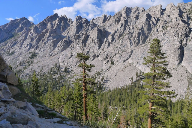
East Vidette seen from the JMT

There was still over an hour of sunlight left, giving us a chance to casually set up camp and relax. It seemed like all the JMT'ers and PCT'ers were also settling down, as every possible nearby site seemed to be occupied by them. This was the time of year when JMT season and PCT season converged in this particular area, and we felt slightly out of place being what seemed to be the only ones who were not thru hikers.
A light breeze had began blowing through the valley, keeping all the mosquitoes at bay. Craig and Dave set up their tents and I set up my bivy at an open spot 300 ft away from Bubbs Creek, at the perfect spot where I would be able to drift off to sleep listening to creek sounds without it being too loud. As sunset arrived, I took a short walk along the JMT, admiring the orange hues lighting up East Vidette, which looked enormous from this position.


We had a leisurely wake-up the next morning and headed back south along the JMT, planning to tag nearby Mt. Bago. Thru hikers were still spread out in the woods on either side of the trail, organizing their enormous stockpiles of gear ahead of the day's hike.
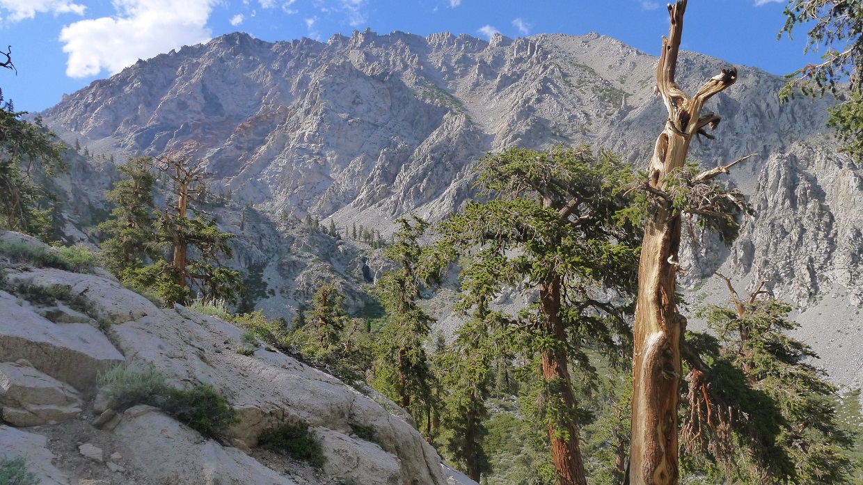
morning view of East Vidette

We took the JMT up to an intersection with a trail heading northwest to Charlotte Lake, and began cross countrying westward towards Mt. Bago. We eventually found ourselves in a small bowl east of Mt. Bago. From there, there were several ways up. We took a broad class 1-2 eastern ridge, which looked the most solid. It took no time at all to reach the summit, and pretty soon we found ourselves gazing west into Kings Canyon several thousand feet below. There was another peakbagger at the summit when we arrived. He mentioned that this was his 6th time on Bago, and that he did it for the view, which in his opinion was one of the most impressive in the entire Sierra.
route up (and down) Bago, seen from the east

Charlotte Lake

summit ridge

summit views


Seizing the opportunity to take what looked like a nice scree descent, we dropped directly into the bowl east of the summit, coasting down on what felt like hardened clouds. It was over in less than 5 minutes, and we headed back east to the trail.
descent off Bago

We headed east on the trail, leaving the JMT shortly after and continuing east towards Kearsarge Pass. About 1.3 miles after leaving the Bago turnoff, Craig pointed out Mt. Rixford to the north, and said that I might consider tagging it. It looked fairly close and I still had a bit of energy, so I decided to give it a go. I ascended directly up its class 2 south ridge, gaining about 1,800 ft to its summit. The summit views were somewhat hazy, but it was still fun.
looking up at Rixford from the trail

views from south ridge


summit views


My descent route followed a cruddy gully east of the main ridge. It had looked like a nice scree ski from above, but turned out to be hard compacted scree. In the end, I would recommend taking the south ridge both up and down.

Back at the trail, I refilled a few water bottles at a nearby creek, and walked another 1.3 miles to Kearsarge Pass, noting how different the Kearsarge Pinnacles looked from this side.

The remaining 4.7 miles back to Onion Valley after Kearsarge Pass went without a hitch. It was definitely more busy on the eastern side of the pass, with numerous dayhikers and backpackers whose purpose was to hike to the pass and back. Several were camped along the shores of Gilbert and Flower lakes, gazing off towards the majestic crags of University Peak.


I joined back up with Craig and David just as they were getting back to the trailhead. David was not doing too well. He had started feeling ill shortly after I had left for Rixford, and the remaining distance up and over the pass had not been very pleasant for him. It seemed like he had a combination of dehydration and altitude sickness, having not been up at altitude for a while. He slowly drank half a bottle of water, which came right back up after a few minutes. We threw our packs into the trunk of the car, and Craig drove us back towards San Diego as David slowly recovered.
Final Stats
31.5 miles
14,610 ft gain/loss

Weather Forecasts
Trailhead
all peaks
Summitpost Pages
Mt. Gould
Dragon Peak
East Vidette
Mt. Bago
Mt. Rixford
Peakbagger Pages
Mt. Gould
Dragon Peak
East Vidette
Mt. Bago
Mt. Rixford
Our planned approach to East Vidette (see map) was to hike 4.7 mi from Onion Valley (9,200 ft) to Kearsarge Pass (11,760 ft), drop 2.4 miles down the other side of the pass and hit the JMT, then follow the JMT for about 3 miles to an elevation of ~ 10,100 ft to the east side of East Vidette before cross countrying to the start of East Vidette's class 3 East Ridge. In addition to East Vidette, we planned on possibly checking out a few other peaks.
| Peak | Elevation | Topographic Prominence | Summit Coordinates (lat/lon) |
|---|---|---|---|
| Mt. Gould | 13,005 ft | 1,030 ft | 36.7798, -118.3776 |
| Dragon Peak | 12,959 ft | 328 ft | 36.7900, -118.3757 |
| East Vidette | 12,355 ft | 249 ft | 36.7440, -118.4004 |
| Mt. Bago | 11,870 ft | 1,142 ft | 36.7701, -118.4379 |
| Mt. Rixford | 12,887 ft | 584 ft | 36.7849, -118.3987 |
Getting to the trailhead
Trailhead coordinates (lat/lon): 36.772560, -118.341186
Craig, David, and I arrived at Onion Valley Trailhead sometime around midnight on Friday June 14. Not being able to locate a campsite, we pulled out our sleeping bags and slept in a dirt pullout on the side of the road. The next morning, I woke up at 4:35 am, quickly packed my stuff, and started walking up the road to Onion Valley Trailhead. I had planned to check out Mt. Gould and maybe Dragon Peak, and needed to start early. Craig and David planned to wake up around 7am, and be up at Kearsarge Pass no later than 10am.
It was nice and cool with the temperature in the low 50s as I made my way to the trailhead by 5am. It was a clear day, another perfect day for hiking. My plan was to hike 4.7 mi up to Kearsarge Pass, cache my heavy pack, and take a daypack up to Gould and Dragon. The Kearsarge Pass Trail was very gentle, gaining maybe 10 ft for every 100 ft traveled owing to the fact that this trail was originally built for and still used for stock travel, not human traffic.
John Muir wilderness sign, shortly after entering the trail

sunrise glow on University Peak


Gilbert Lake (10,400 ft)


Kearsarge Pass

After a quick snack break at Kearsarge Pass, I began slogging up Mt. Gould's sandy South Ridge. What appeared to be the summit from below turned out to be a false summit. The true summit lay behind it to the north. It contained a short and fun class 3 summit block. From the summit, there was a spectacular expansive view of Kearsarge Lakes.
Mt. Gould's South Ridge viewed from Kearsarge Pass

summit block

view south from summit

southwest

Great Western Divide

Rae Lakes (northwest)

Now it was time to head over to Dragon Peak, roughly 0.8 linear miles to the north. Immediately north of Gould was a short section of talusy plateau which was simply walked across, followed by a short section of loose-ish class 3. I remained slightly over on the eastern side of the ridge until shortly before Gould Pass, where I switched to the crest to find more solid and enjoyable class 3 rock.


A few hundred feet north of Gould Pass was the first of two large pinnacles which I weaved behind, now staying on the west side of the ridge. As I reached a prominent notch east of a second pinnacle, the remaining route to the summit was obvious: an exposed class 3 crack on a westward facing slab. Although it looked scary, there were plentiful holds and the rock was very reliable.


views from Dragon Peak (This was the last trip where I used HDR photography in midday lighting. Horrible contrast!)


I retraced my steps back up and over Gould and down to Kearsarge Pass, arriving a few minutes after 10am. Since I saw the signal that Craig and David had left indicating that they had already passed through there, I picked up my backpack and continued west towards the JMT.
back on Gould


Bullfrog Lake


descending towards Bubbs Creek

I caught up to Craig and David at a junction at Lower Vidette Meadow, and we hiked south along the JMT for another 0.4 miles before seeing some bear boxes off to the right and a pretty nice looking campsite which was vacant (9,550 ft). We decided to stop there and drop off the full packs as well as grab a quick bite to eat. The air down there was quite still, and I found myself slapping mosquitoes every few seconds.
We stashed the large packs behind some trees, filled up our day packs, and followed the JMT southeast along Bubbs Creek for another 1.8 miles to an elevation of ~10,100 ft. From the switchbacks south of Bubbs Creek, East Vidette had looked incredibly impressive and dominating, but as we continued upstream, this impressiveness slowly diminished until the mountain looked like any other nearby peak, with its east ridge looking like a large pile of rubble. It made sense, seeing that the mountain was really just a nipple with under 300 ft of prominence at the end of a long ridge extending from Mt. Stanford further south.
After leaving the trail, we crossed Bubbs Creek and aimed directly for the east ridge. The first 30 minutes found us in a maze of ledges, gradually zigzagging up towards the ridge proper. Once on the ridge (which I expected to be nice and solid), we found the ridge crest broken and divided by a series of loose scree crud chutes. This continued until 200 ft of elevation below the summit, where we were finally able to enjoy a very short stretch of class 3 scrambling. Right as the fun part had begun, I was surprised to see that there was no more mountain above us.
ascending East Vidette


summit

view northwest

north

southeast

south

southwest

Our descent route was slightly different than our ascent, utilizing a scree-filled gully just north of and paralleling the east ridge downward. This gully was sandy enough that most of the small rocks we kicked down stopped after a few feet, and we didn't have to worry about showering eachother in a barrage of rocks. I was thinking how fun this gully must be in the snow, and how nice a glissade would feel right now. Afternoon lighting cast dramatic shadows on the Kearsarge Pinnacles to the east, which looked way more impressive from this side compared to where people usually glance at them from Kearsarge Pass. Upon getting back to Bubbs Creek, we emptied our shoes of sand and scree before getting back on the JMT and walking down to camp.


East Vidette seen from the JMT

There was still over an hour of sunlight left, giving us a chance to casually set up camp and relax. It seemed like all the JMT'ers and PCT'ers were also settling down, as every possible nearby site seemed to be occupied by them. This was the time of year when JMT season and PCT season converged in this particular area, and we felt slightly out of place being what seemed to be the only ones who were not thru hikers.
A light breeze had began blowing through the valley, keeping all the mosquitoes at bay. Craig and Dave set up their tents and I set up my bivy at an open spot 300 ft away from Bubbs Creek, at the perfect spot where I would be able to drift off to sleep listening to creek sounds without it being too loud. As sunset arrived, I took a short walk along the JMT, admiring the orange hues lighting up East Vidette, which looked enormous from this position.


We had a leisurely wake-up the next morning and headed back south along the JMT, planning to tag nearby Mt. Bago. Thru hikers were still spread out in the woods on either side of the trail, organizing their enormous stockpiles of gear ahead of the day's hike.
morning view of East Vidette

We took the JMT up to an intersection with a trail heading northwest to Charlotte Lake, and began cross countrying westward towards Mt. Bago. We eventually found ourselves in a small bowl east of Mt. Bago. From there, there were several ways up. We took a broad class 1-2 eastern ridge, which looked the most solid. It took no time at all to reach the summit, and pretty soon we found ourselves gazing west into Kings Canyon several thousand feet below. There was another peakbagger at the summit when we arrived. He mentioned that this was his 6th time on Bago, and that he did it for the view, which in his opinion was one of the most impressive in the entire Sierra.
route up (and down) Bago, seen from the east

Charlotte Lake

summit ridge

summit views


Seizing the opportunity to take what looked like a nice scree descent, we dropped directly into the bowl east of the summit, coasting down on what felt like hardened clouds. It was over in less than 5 minutes, and we headed back east to the trail.
descent off Bago

We headed east on the trail, leaving the JMT shortly after and continuing east towards Kearsarge Pass. About 1.3 miles after leaving the Bago turnoff, Craig pointed out Mt. Rixford to the north, and said that I might consider tagging it. It looked fairly close and I still had a bit of energy, so I decided to give it a go. I ascended directly up its class 2 south ridge, gaining about 1,800 ft to its summit. The summit views were somewhat hazy, but it was still fun.
looking up at Rixford from the trail

views from south ridge


summit views


My descent route followed a cruddy gully east of the main ridge. It had looked like a nice scree ski from above, but turned out to be hard compacted scree. In the end, I would recommend taking the south ridge both up and down.

Back at the trail, I refilled a few water bottles at a nearby creek, and walked another 1.3 miles to Kearsarge Pass, noting how different the Kearsarge Pinnacles looked from this side.

The remaining 4.7 miles back to Onion Valley after Kearsarge Pass went without a hitch. It was definitely more busy on the eastern side of the pass, with numerous dayhikers and backpackers whose purpose was to hike to the pass and back. Several were camped along the shores of Gilbert and Flower lakes, gazing off towards the majestic crags of University Peak.


I joined back up with Craig and David just as they were getting back to the trailhead. David was not doing too well. He had started feeling ill shortly after I had left for Rixford, and the remaining distance up and over the pass had not been very pleasant for him. It seemed like he had a combination of dehydration and altitude sickness, having not been up at altitude for a while. He slowly drank half a bottle of water, which came right back up after a few minutes. We threw our packs into the trunk of the car, and Craig drove us back towards San Diego as David slowly recovered.
Final Stats
31.5 miles
14,610 ft gain/loss

Weather Forecasts
Trailhead
all peaks
Summitpost Pages
Mt. Gould
Dragon Peak
East Vidette
Mt. Bago
Mt. Rixford
Peakbagger Pages
Mt. Gould
Dragon Peak
East Vidette
Mt. Bago
Mt. Rixford
Hey man, your stuff is continually awesome. Thank you so much for all this work. I use it whenever I head into the backcountry.
ReplyDelete