
June 28, 2013
Koip and Kuna are two peaks located in the Yosemite backcountry, surrounded by miles of rolling grassland. Even though the peaks are located less than a quarter mile from eachother, each one is the highpoint of a specific ridgeline. Koip Peak is the highpoint of Koip Crest, which branches off to the southeast, and Kuna Peak is the highpoint of Kuna Crest, which branches off to the northwest.
After finishing up the Dinner Plate Traverse the preceding day, Tommey and I were looking for an easier hike to relax our legs on. I recalled climbing Koip Peak as part of a traverse in 2012, and not being able to get to Kuna Peak because it was getting late in the day. The peaks were not difficult themselves, and I remembered the approach fairly well. We decided to go for it.
Our planned route started from a parking lot in Dana Meadows (9,700 ft). From the trailhead, it is 6.1 miles on a trail to Parker Pass (11,100 ft). On the way to Parker Pass, the trail passes two junctions, one at 2.7 mi, and another at 3.9 mi. After Parker Pass, the trail drops down 300 ft in 1.7 mi, then ascends 1.7 mi to Koip Peak Pass (12,270 ft). From Koip Peak Pass, leave the trail and head up a talus slope west to Koip Peak (12,962 ft). Kuna Peak (13,002 ft) is a short traverse to the west of Koip.
Getting to the trailhead: From the eastern entrance into Yosemite National Park on Highway 120 (Tioga Pass Rd), travel 1.5 miles into the park. The trailhead should be to the left with a sign indicating "Mono Pass Trail."
Trailhead coordinates (lat/lon): 37.891045, -119.262564
After spending a night at Tuttle Creek Campground near Lone Pine, it was almost noon as we pulled into the trailhead for Kuna and Koip in Yosemite. The weather was warming up into mid to high 70s at Dana Meadows, and the sky was blue with a few puffy clouds. We hit the trail at 11:40 am. A sign placed shortly after the trailhead indicated 5.3 miles to Parker Pass, but I always found those signs to be a little off.
trailhead

Mammoth Peak (not the same as Mammoth Mountain)

early spring due to a low snow year

This part of Yosemite was very picturesque. There were several stream crossings the first mile, and flowers bloomed frequently in open meadows. The mosquitoes seemed to be enjoying it as well. Throughout the first 1.5 miles, we were getting bit left and right. The only way alleviate them was to keep moving.
2.7 miles after the trailhead, we turned left at the first junction.


1.2 miles after the first junction, we turned right at the second junction 2.2 miles before Parker Pass. At first glance, it didn't look too clear where the trail was headed to. After a few seconds, we realized that it turned a sharp right and cut across a meadow. The trail was only a slight indentation in the think grass, and we had to be careful not to slip in mud. After the meadow crossing, the trail contoured onto a small ridge and was easily visible again.
meadow crossing

flowers after meadow crossing

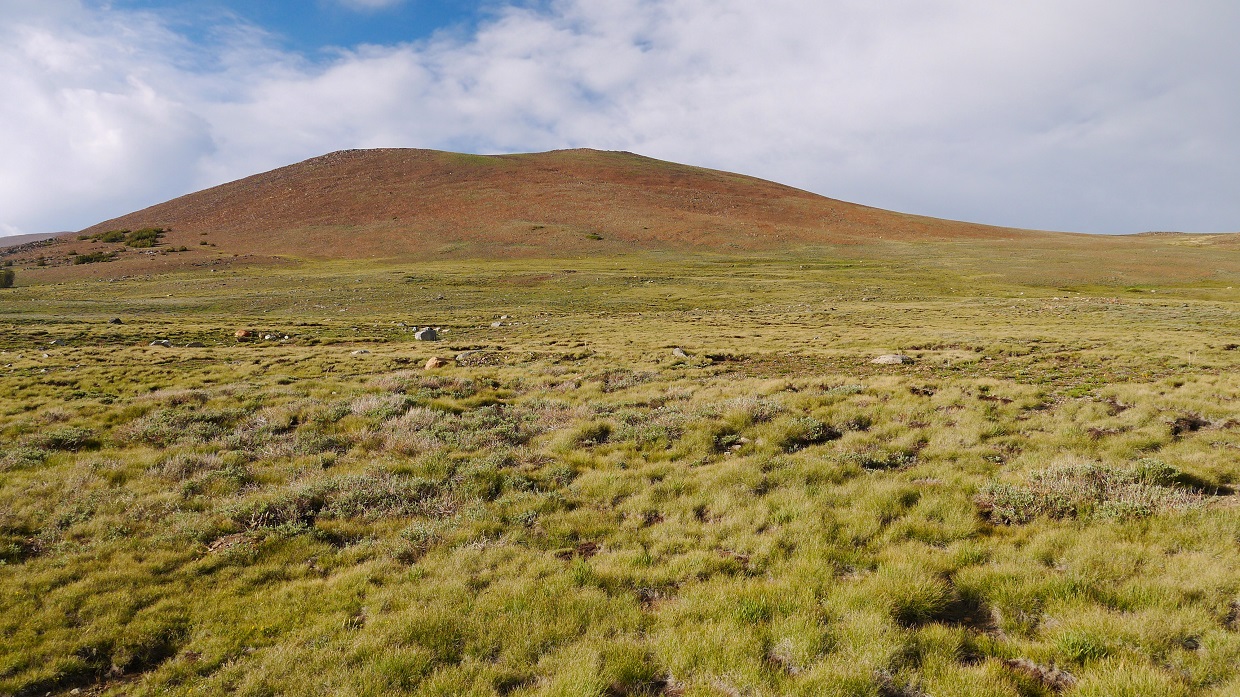
Shortly before Parker Pass, the trees vanished and we found ourselves hiking through an open grassland. It was amazing alpine terrain where everything was green. The trail was a little muddy in a few spots, but it was not a hindrance. Best of all, there were no mosquitoes.

Upon reaching Parker Pass, we stopped for a short snack. The weather was perfect in the mid 60s, and a slight breeze kicked up here and there. There was a man sitting there, leaning against a signpost reading a book.
From Parker Pass, the trail descended southeastward. It now resembled a use trail, slightly harder to follow than the trail leading up to Parker Pass, but not by much. It seemed that numerous streams flowing through the area had washed out portions of the trail now and then. There were several stream crossings, with one of them being slightly sketchy.
other side of Parker Pass

one of many crossings

Pretty soon we came to the base of several switchbacks ascending the northwest slope of Parker Peak, then contouring southwest towards Koip Peak Pass.

Those switchbacks were nicely built, well designed for hikers and backpackers. They were easy to follow, and contained nice views towards Mono Lake. Several patches of Polemonium (Sky Pilot Flower) appeared frequently.


sign at Koip Peak Pass

From Koip Peak Pass, we noticed dark clouds building up to the northwest. Like many Sierra thunderstorms, this one had seemed to develop out of nowhere. Since it looked like the wind was pushing the storm further northwest and away from us, we pressed onward.
view of Koip Peak from Koip Peak Pass

From Koip Peak Pass (12,270 ft), we left the trail and made a beeline for Koip Peak (12,962 ft). It was all talus slog, but easygoing. The terrain remained pretty much class 1 all the way up to the summit.
view of Parker Peak from the base of Koip

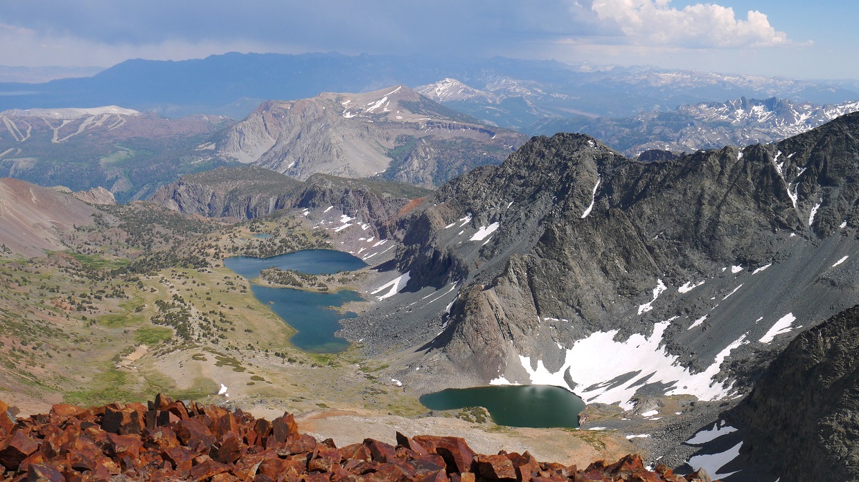
view southeast towards Alger Lakes

Mono Lake making an appearance

dramatic sky

summit views from Koip Peak


The traverse to Kuna Peak (13,002 ft) was a straightforward walk, consisting of rolling talus and class 1-2 terrain. It took about 15 minutes to traverse the distance between the two peaks.

Tommey approaching Kuna Peak summit

There were amazing views all around Kuna Peak, especially towards the Cathedral and Ritter ranges.

looking northwest down the Kuna Crest


After 15 minutes on Kuna's summit, we headed back, traversing back over Koip along the way.
view of Koip from Kuna

On the way back to Koip, I noticed an oddly shaped rock sticking out of the ground. As we came closer, it turned out to be a propeller.

back on Koip

descending back to Koip Peak Pass


feeling small

descending switchbacks after Koip Peak Pass

view of Mt. Lewis from switchbacks (Parker Pass is just out of frame to the far left)

another view of Mono Lake (left) and Grant Lake (right)

back at Parker Pass

screensaver pic
The storm was dissipating fast, and sunlight flooded onto the hills and valleys. Lighting improved dramatically and we were stopping constantly for photos.


back to Mosquitoland

For the last mile, slapping and scratching, we hiked as fast as possible as we were bombarded by mosquitoes. I felt them on my arms and neck constantly. If I took my hands away for as little as half a second, they would come buzzing right back. We got to the car, jumped in, and headed out before any more mosquitoes could get to us. We stopped very briefly on the way out so that I could snap a photo of the sunset on Mammoth Peak.

Final Stats
20.6 miles
5,000 ft gain/loss

Weather Forecasts
Trailhead
Parker Pass
Koip/Kuna peaks (Kuna Peak has an elevation of 13,002 ft. Keep in mind that this forecast is for 11,883 ft)
Peakbagger Pages
Koip Peak
Kuna Peak
Summitpost Pages
Koip Peak
Kuna Peak
Koip to Kuna traverse
Other
High Sierra Topix message board
Inyo National Forest
Great Trip Report!
ReplyDeleteHuh, interesting wreckage find on Koip. It looks like there was a B-24 scattered on the mountainside from an unknown date. http://planecrashmap.com/plane/ca/427118/
Thanks for putting this together. Was there over Labor Day weekend with my 15yr old son. Made a loop back over Donahue pass. We spent the night between Parker and Koip. It hit 20 degrees with heavy winds. Pretty intense. We did not hike the peaks as we were trying to make miles. Regret not doing that after seeing your pics. Putting together an album on Pages. Will flag you if you're interested. We're training for JMT hopefully next summer. Thanks again, Michael Takatsuno
ReplyDeleteThanks for putting this together. Was there over Labor Day weekend with my 15yr old son. Made a loop back over Donahue pass. We spent the night between Parker and Koip. It hit 20 degrees with heavy winds. Pretty intense. We did not hike the peaks as we were trying to make miles. Regret not doing that after seeing your pics. Putting together an album on Pages. Will flag you if you're interested. We're training for JMT hopefully next summer. Thanks again, Michael Takatsuno
ReplyDeleteFantastic shots! And great write-up. The Cathedral Range views really are something… all of those are. It looks like it was maybe a little scary with that nearby storm being way up there, but thankfully it didn’t bother you and it sure made for some great lighting. That area is amazing and what got me hooked when I started backpacking after spending 4 days/3 nights basically hiking around Kuna Crest. I also drew in the switchbacks on a photo :) http://www.hikingmike.com/backpacking-trips/yosemite-sep-2004/
ReplyDeleteGreat photos and write-up! Just did this route yesterday and added in Parker Peak for good measure. The scenery and views were amazing! Almost didn't see anyone all day, but a group of four showed up right as we were heading down Parker. It's still early in the season (even for a low snow year) and there is snow crossing right at the top of the Koip Pass Switchbacks with SEVERE consequence, but otherwise it was a very chill day. Also saw the plane crash debris - was able to do some research and found out it was a B-24 that crashed on June 21, 1943 and killed 7 people ( https://aircraftwrecks.com/pages/b-24e%206-21-43.htm ).
ReplyDeleteI am thinking of doing this in a few weeks. How big was the snow crossing? How sketchy was the crossing?
Delete