
back to home page
April 20-21, 2013
Three Giants tower over the Baxter Pass Trail as it gently snakes along the side of a creek, gradually ascending a wide, scenic canyon to Baxter Pass. Further up towards the west, the canyon ends at a small moraine bowl. A series of sharp ridges rise up towards the west of the moraine bowl, blocking any easy access further west. Mt. Mary Austin (13,051 ft) and Black Mountain (13,291 ft) dominate a ridge on the south side of the moraine. Diamond peak (13,127 ft) dominates the north side.
I was planned to climb Diamond Peak with a group of 9, organized by Dagmar. The other two peaks were considered bonuses if there was extra time. The plan was to start climbing from Baxter Pass Trailhead (6,040 ft) Saturday morning, reach High Camp (10,800 ft) later that day, climb Diamond Peak on Sunday, then descend back to Baxter Pass Trailhead the same day.
Climber.org has a very nice description of getting to the trailhead.
Trailhead coordinates (lat/lon): 36.844856, -118.297698
Baxter Pass Trailhead

Upon reaching the trailhead Friday night, we met Tommey, who had just climbed Diamond Peak earlier that day. He mentioned that the trail was clear of snow until 10,000 ft, and after that it was easy walking to High Camp. He asked if anyone would like to head up there and climb Black Mountain with him the following day. Hearing about the lack of snow, I figured that we would reach camp very early with nothing to do for the rest of the day, so I joined Tommey for his hike. Fran said that he would like to come too.
The next day, Tommey, Fran, and I were the first ones out on the Baxter Pass Trail by 6am, hiking up towards Black Mountain. The first few miles consisted of typical desert terrain. Short, stout patches of shrub dotted the landscape. I started to feel a little winded trying to keep up with Tommey (who was planning to dayhike Black Mtn) while carrying my overnight pack. I slowed my pace, gradually falling behind. I looked back to see that Fran was nowhere in sight. Later he told me that he had gotten lost at the first creek crossing.

A few pine trees appeared here and there. Many were charred, indicating that a fire had come through the area some years ago.


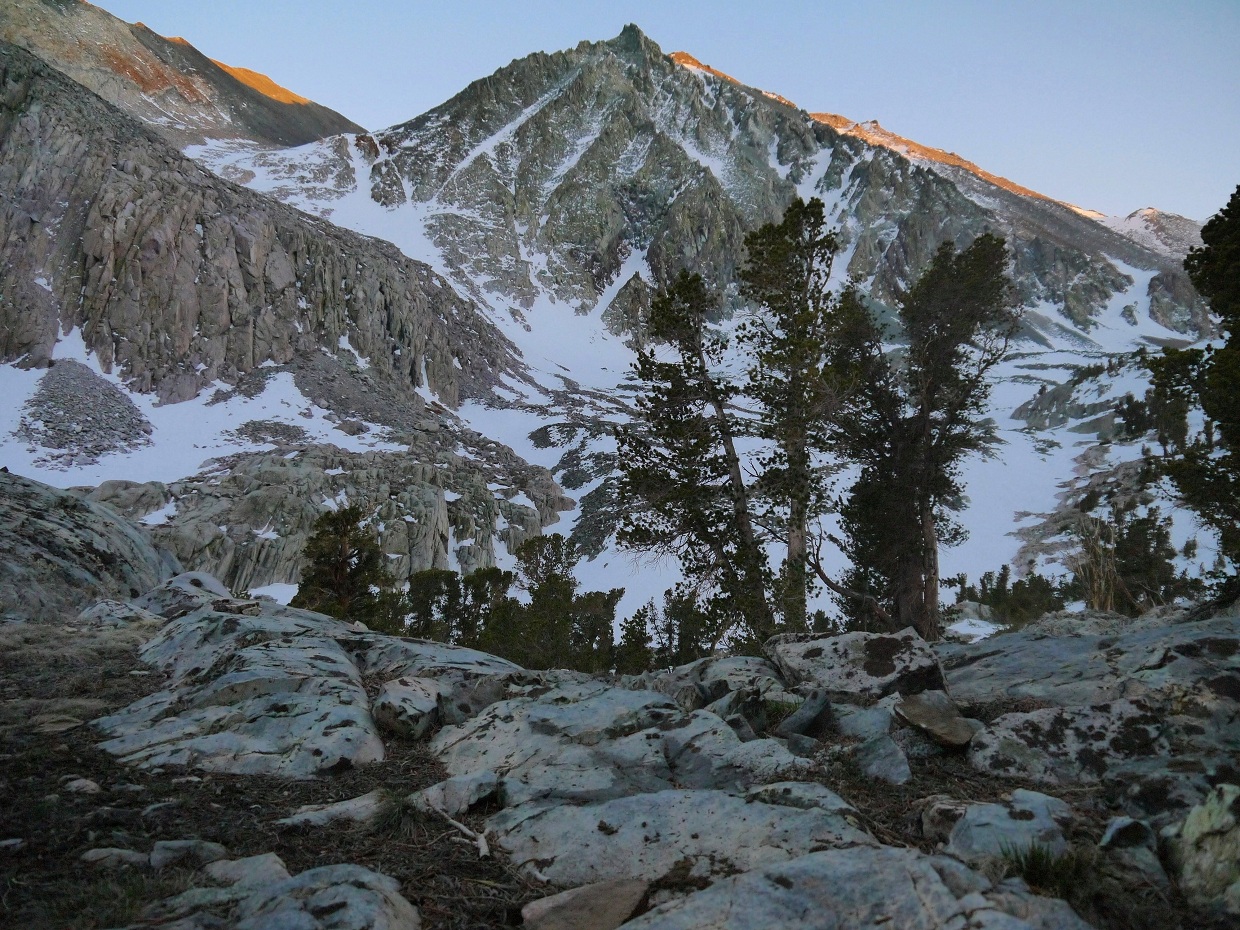
There are two main creek crossings within the first 3 miles of trail. The first crossing (6,700 ft, 1.1 mi from trailhead) is trivial. The second crossing (8,300 ft, 2.5 mi from TH) is a little more tricky as one has to walk on top of half submerged floating logs. After the second crossing, the trail gently switchbacks up 200 ft until the terrain flattens out at a meadow at 8,500 ft. I got my first glimpse of Diamond Peak from here.
false summit of Mt. Mary Austin, viewed from switchbacks immediately after second creek crossing

view of Diamond Peak from meadow at 8,500 ft

The trail continued gently up through the meadow, becoming slightly difficult to follow at times because of vegetation overgrowth. I ran into Tommey, who was waiting for me on a rock. After that, we hiked together again, Tommey slowing down so I could keep up. About 1.8 miles after the second creek crossing, we reached Topo camp (10,000 ft). It was a really pleasant spot. There were several soft, flat areas where someone could easily set up tents or bivys. A series of several thousand foot high crags rose up to the south, providing some awesome scenery. A grove of trees provided shade, which would be much appreciated during summer when the area heats up. A creek flowed a few hundred feet south of the camp.
looking south from Topo Camp

From Topo Camp, the Baxter Pass trail begins to ascend the north side of the canyon towards Baxter Pass. High camp lies further up the main canyon. Tommey and I left the trail and began cross countrying it up the main canyon. We encountered snow shortly above 10,000 ft. Because the snow was well consolidated and blanketed most of the ground, the climbing (which was more like simple walking) was very easygoing. The snow slope rarely increased to more than 20 degrees of incline.
We caught a glimpse of Mt. Mary Austin's class 2 northwest couloir, a popular route up the mountain.

Many times I felt that we were walking over snow bridges. I could hear gurgling sounds from the creeks flowing below. 0.9 miles after Topo Camp, we reached High Camp (10,800 ft, 5.2 mi from TH). High camp was nestled within the the highest grove of trees in the canyon. A small creek flowed through it. There were several good camping spots, enough for a very large group. I was glad to take off my heavy pack and drop several pounds of overnight gear I wouldn't need for Black Mountain.
We continued hiking up the main canyon, walking on gentle, sloping, consolidated snow. The main canyon ended at a bowl at 11,300 ft, 5.8 miles from TH (In this trip report, I will refer to this bowl as "Bliamond Bowl") Black mountain lay on the left (south) side of the bowl, and Diamond Peak lay to the right (north) side. Both peaks were accessible as class 2 climbs from Bliamond bowl.
above High Camp

Bliamond Bowl

This was our ascent route up Black Mountain from Bliamond Bowl (the true summit is not visible in this picture). Because we didn't know where the actual summit was in particular, we went off towards the right, and upon reaching a ridge, traversed left towards the highpoint.

The first few hundred feet of climbing above Bliamond Bowl (11,300 ft) consisted of loose, flaky scree. At 12,000 ft, the rock became more solid and enjoyable.


looking at our route from 12,000 ft

Upon reaching the ridge (13,000 ft) we could see the highpoint to the east, standing just over 200 ft higher.

The ridge consisted of very enjoyable class 2-3 traversing. Rock quality was solid for the most part, and there were great views in all directions. It was slow going as we tried to avoid softening snow. Occasionally, we postholed up to our knees.


looking north

We reached the summit of Black Mountain (13,291 ft) at 1pm. After digging around in the snow for a few minutes, I located the register, which consisted of signatures from 2006 at the earliest.
looking northeast towards Mt. Mary Austin

East

South

West

After spending 40 minutes at the summit area, we decided to head back down Black Mountain rather than traverse to Mt. Mary Austin. We donned crampons and headed down a snow gully directly below the summit. Back at 12,200 ft, we ran into Pat and Craig, who had started up with the main group, gotten to camp early, and decided to give Black Mountain a try. At that very moment, we saw and heard several rocks tumbling down the southeast slope of Diamond Peak, which was our planned route for the next day. It looked like rocks the size of cars were tumbling down the mountain.
We bid Pat and Craig good luck on summiting, and continued down. Because we didn't much enjoy the scree slope above Bliamond Bowl while ascending, we picked an alternate descent route: a 40 degree snow chute. The snow was very soft now. It balled up on my crampons and I had to frequently knock it off with my ice axe. The chute consisted of snow that would alternate between being very soft for a few feet and then icy for the next few feet. These transitions caught us off guard at times. Tommey ended up self arresting 3 times. At one point, I stopped to adjust a crampon, then lost balance and slid down the chute. Luckily, I was only 100 ft above Bliamond Bowl, and came to a stop when the ground flattened out. Because my pack was open, most of the gear and food inside was now scattered all around me. My ice axe was still anchored into the snow 100 ft above me, where I had lost balance. I took off a crampon and used it as an ice axe, plunging its spikes into the snow to pull myself up. I retrieved the axe and everything else that had fallen out of my pack, then continued down.
Tommey was way ahead now, and I ran down the gentle snow slope to catch up. Just as I was about to reach High Camp, I heard his voice call out that he was heading down (He was not planning to spend the night, and wanted to get back to the trailhead before dark). I got back to camp to find most of the group there relaxing. Dagmar had gone up towards Diamond Peak to scout out the next day's route, and Craig and Pat were still on Black Mountain.
It was just after 5pm, still pretty early in the day. I spent some time taking pictures of a unnamed peak on the ridge between Diamond Peak and Black Mountain. We all had dinner on a nice patch of sunny rock above camp. Dagmar arrived at camp shortly after, noting that the southeast slope was in climbable condition.
false summit of Mt. Mary Austin from camp

unnamed peak between Mt. Mary Austin and Black Mountain

Northwest couloir of Mary Austin to the left

dinner with a view

looking up the main canyon

more artsy pictures

The moment the sun dropped behind mountains to the west, everyone quickly finished eating and crawled into their warm sleeping bags. Just as I was about to crawl into my bivy sack at 7:15 pm, I heard the Pitter-Patter-Pitter-Patter of someone running on snow. It was Pat, running back to camp in the fading light. A few minutes later, Craig came into view. They had successfully summited Black Mountain.
The next morning, everyone started for Diamond Peak in 1-3 person subgroups. I woke up at 5am to see a light from Mayukh's headlamp bobbing up and down, heading up the main canyon. A few moments later, George left camp. I started making breakfast: mac and cheese. I ended up addling less water than I should have. It felt like eating some kind of rubber brick. I finished up breakfast as Fran and Doina were leaving camp. After packing everything up, I left camp at 5:45 am, quickening my pace, eager to get up in front in order to avoid any potential rockfall that might be caused by climbers above me (especially after witnessing that giant rockfall the previous day).
I reached Bliamond Bowl at sunrise, and snapped a few pictures.


This was my route to the start of the class 2 southeast slopes of Diamond Peak. The slope gets more apparent as one walks over to it.

Mayukh climbing up the slope (note remnants of a small avalanche to his left)


I walked around the north side of Bliamond bowl to the base of the southeast slope (11,400 ft), and started up, walking on nice, consolidated snow.
George ascending

Mayukh and loose rock

looking back down from 12,300 ft

looking up from 12,300 ft

Starting at 12,300 ft, I managed to move to a line of ascent with better rock quality by climbing to the right to a small, semi-ridge. The semi-ridge was no more than a gentle spine of rocks.
looking south at Black Mountain

Southwest

At 12,700 ft, I came to a plateau with the summit of Diamond peak visible to the northwest. The remaining climbing from here consisted of very solid rock.

I arrived at the summit (13,127 ft) at 7:40 am and was greeted with awesome views in all directions. There was a small register under some rocks.


North

South

Southwest


Northwest

overview of the southwest slope route of Diamond Peak, as seen from the summit of Black Mountain the previous day

Pat approaching summit

Dagmar


At 9am, Dagmar, Pat, and I left the summit and hurried down just as we saw the remainder of the group clambering up to the summit plateau. We wanted to get down the scree section before anyone else would be descending above us, knocking rocks down.
Pat descending on summit plateau

last look southwest

A few short moments later, I had descended back into Bliamond Bowl. The snow had already softened enough for me to glissade on it. While walking back down the main canyon, I decided to go for Mt. Mary Austin since it would be well over an hour before everyone got back to camp.
I reached the base of the northwest couloir (11,000 ft) a little after 10am. Since this couloir sat on the north slopes, it had received sunlight for a much shorter period of time as compared to the southeast slopes of Diamond Peak. The snow was still icy here. I donned crampons and started up the couloir.
It soon because apparent that the first portion of the couloir (between 11,000 and 11,400 ft) was the steepest it was going to get, about 30 degrees at the most. After that, the slope dropped to about 20 degrees at the most. I took off the crampons as they slowed me down while not needed.
looking up the couloir from 11,500 ft

The couloir ends at a saddle at 12,550 ft. Upon reaching the saddle, one should turn left and follow a gradual ridge to the summit (13,051 ft). I started ascending to the left starting at 12,100 ft. Though this was a faster route compared to if I were to ascend to the saddle before turning left, this route consisted of several large chunks of talus that was often unstable.
looking southeast from 12,800 ft: The true summit is a few minutes behind that bump to the right.

I arrived on the summit just after 11am. It surprised me how good the views were, considering that Mt. Mary Austin was not a prominent peak for its location. Most climbers hold a lesser interest in Mt. Mary Austin than in its higher neighbors: Black Mountain, Diamond Peak, and Mt. Baxter.
I looked around for a register and eventually located it, but there was was no pen or pencil inside, so I couldn't sign it.
Southwest

South

North

Black Mountain

Mt. Brewer is the prominent peak in the distance.

looking down towards High Camp on descent

I descended back to camp just before 12pm to find most of the group breaking camp. Dagmar, Craig, and Beto had left camp not too long ago. I packed up and started after them, hiking down the main canyon back towards the Baxter Pass trail. We arrived back at Baxter Pass Trailhead at 2:25 pm.
Final Stats
19.6 miles
12,200 ft gain/loss
(map is approximate)

Weather Forecasts
Trailhead
Black Mtn, Diamond Pk, Mt. Mary Austin (These peaks have elevations slightly over 13,000 ft. Keep in mind that this forecast is for 12,143 ft)
Peakbagger Pages
Black Mountain
Diamond Peak
Mt. Mary Austin
Summitpost Pages
Black Mountain
Diamond Peak
Mt. Mary Austin (note that the Northwest Couloir and North Couloir are NOT the same route)
No comments:
Post a Comment