
May 11-12, 2013
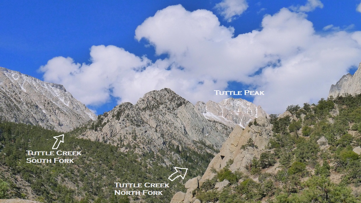
Mt. Langley is the Sierra's southernmost fourteener. When viewed from the south, the mountain resembles nothing more than a large talus pile which can easily be walked up. When viewed from the north, the mountain presents itself as something much more exciting, revealing a series of cracks, aretes, and gullies on its seemingly vertical north face. One of Langley's classic north face features is the class 3 Northeast Couloir, which begins at around 11,900 ft in the north fork canyon of Tuttle Creek and ends just east of the summit of Langley. The Northeast Couloir is most frequently done as a snow climb between March and early May and is not recommended during the summer due to the screeish nature of the couloir.
| Peak | Elevation | Topographic Prominence | Summit Coordinates (lat/lon) |
|---|---|---|---|
| "Tuttle Peak" | 12,877 ft | 312 ft | 36.541622, -118.235013 |
| Mt. Langley | 14,026 ft | 1,197 ft | 36.523449, -118.239526 |
Getting to the trailhead: Follow the directions listed near the bottom of this page. The last mile or so requires 4WD.
Trailhead coordinates (lat/lon): 36.553919, -118.184265
the Northeast Couloir route seen from Lone Pine

Damian, Dagmar, Katy, and I stared hiking from Tuttle Creek Trailhead (6,930 ft) at 9:15 am, taking a 1 mile well-defined trail to the Tuttle Creek Ashram, a religious retreat built by Franklin and Sherifa Wolff in 1928. Since 1950, the building has not been used or maintained and has fallen into disrepair. In 1980, the U.S. Forest Service designated the Ashram as a historic site.
Tuttle Creek Trailhead

looking southwest from the trailhead
inside the Ashram (7,760 ft)

After the Ashram, the well defined trail became a faint use-trail, which did a few short switchbacks up to the west, then contoured southwestward towards Tuttle Creek. Upon reaching the creek, the trail paralleled it along its northern side, staying usually within 200 ft of elevation above the creek.
hiking above Tuttle Creek

southern canyon walls

At around 9,000 ft, the trail crossed the creek and ended at a flat area under a grove of conifers. This area was an awesome campsite, and it was evident that previous parties had camped there before. It was around 11:30 am once we reached this spot and took a longish lunch break. Shortly after the flat area, we crossed back over to the north side of Tuttle Creek and located a trail. About a quarter mile later, the trail headed up the the right, bypassing the headwall of a bench. The top of the bench had an elevation of 9,700 ft.
bypassing the bench

After the bench, the trail ended and the canyon ahead became choked up with brush, so we crossed over to the south side of Tuttle Creek and paralleled it upwards. This side of the creek involved hiking across large boulder fields which had accumulated from eons of erosion of the canyon walls.

We ended up setting up camp at a spot not far below the base of the Northeast Couloir. The location was set under a grove of conifers- the highest trees that grew in the canyon. There was a plentiful amount of flat and soft ground for everyone to spread out on. A small creek was accessible less than a minute away.

view from camp

backpacking necessities

Since we had already set up camp and it was only around 3pm, I decided to head off and bag a peak. To the northwest of camp was an unnamed peak that bore 312 ft of prominence. Since the ridge that contained this peak divided the northern and southern forks of Tuttle Creek, I felt it appropriate to dub the peak "Tuttle Peak."
I ascended some easy ledges above camp to the highest trees in the grove, then crossed Tuttle Creek and headed up a prominent canyon to the northwest. There were some large boulders scattered throughout the canyon which were fun to work around. A cascading creek ran through the southern side of the canyon.
looking northwest from the Tuttle Creek crossing above camp

Once in the canyon, there were several chutes visible to the north that headed up towards Tuttle Peak's summit plateau. The first few looked to contain class 5 climbing, so I pressed ahead, hoping to find one that did'nt require anything higher than class 4. Just before what looked like a saddle up ahead in the canyon, I spotted a chute that looked reasonable. It contained a few easy class 3 moves near the top, but was otherwise class 2.

Once above the chute, I walked across the summit plateau to an obvious highpoint.

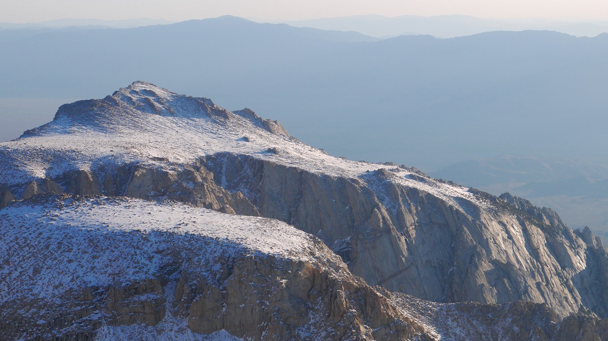
From the summit, there were very impressive views of Langley's north face and Lone Pine Peak's south face. The pinnacles between Mt. Langley and Mt. Mallory seemed to sparkle in the late afternoon sun.
view northeast from summit

east

south-southwest

southwest

west

views of Langley while descending Tuttle Peak


Inyo Mountains

Back at camp, we ate dinner and crawled into our sleeping bags before the sun had completely gone down. Since I wanted to photograph the sunrise from the summit of Langley the next morning, I planned to start climbing the Northeast Couloir in the dark, several hours before sunrise. I set an alarm for 1:30 am, then took about an hour of tossing and turning to finally drift into sleep.
I woke up 15 minutes before the alarm and began heating up water for breakfast: macaroni and cheese. The macaroni tasted rubbery, and I spent some time forcing it down. As I ate, I drifted in and out of a light sleep. The sleeping bag looked so warm and cozy. Did I really want to get up and stumble up an icy couloir for hours in the dark? I laid back down, took a snooze, and woke up again about 10 minutes later. Yes, I did want to do this. Its worth it for the view.
I stumbled out of my bivy sack groping for the headlamp. A thin layer of frost had formed over everything. After a few minutes of hiking, I realized that I had forgotten the ice axe back at camp, and headed back to retrieve it, finally departing from camp at around 3am. 1,000 ft of elevation stood between camp and the base of the Northeast Couloir. I spent about an hour on this section. Usually this part of the route should be covered with snow, but due to the previously dry winter, the terrain was a mix of snow, talus, and boulders. Upon reaching the base of the Northeast Couloir, I could tell that it was going to get increasingly icy higher up. After stopping for a few minutes to don crampons and take out the ice axe, I continued on. As I began climbing up the couloir, I was knocked from the sleepy daze that had followed me for the past hour, and finally perked up. This was starting to be an awesome climb. The couloir stretched up and up into the darkness towards something not yet visible. I began playing songs in my head to the metallic beat of the ice axe and crampons as they came into contact with the snow. The climbing itself was not challenging, but highly enjoyable. The steepest it got was somewhere between 30 and 35 degrees. Pretty soon, the eastern horizon began to light up, and I quickened my pace.
looking down the couloir from ~13,400 ft

I topped out on Langley's summit plateau just as the sun began making its way over the horizon. From there, it was a short walk northeast to the summit.


As I stepped over the last few rocks to the summit, I literally froze out of amazement. The peaks to the north and west were illuminated bright orange by the rising sun in a spectacular fashion.


A large ammo box register stood at the summit, stuffed with several books and various scraps of paper.
altitude sickness???

I could now see the other members of the group near the base of the Northeast Couloir some 2,000 ft below. Because I had some time on my hands before their arrival, I explored the terrain around Langley, descending to an area near Old Army Pass.


I got back to the summit at around 9:30 am to find Dagmar sunbathing on a rock. Damian and Katy arrived a few short moments later. We enjoyed the summit for 30 minutes, then headed back down, passing by another group that had climbed up the same route.
views at 9:30 am


As we reached the top of the couloir, the snow had already softened quite a bit, allowing us to glissade down.

After the couloir, the remaining 1,000 ft of descent to camp went quickly. We relaxed for a bit at camp, then headed out.
large granite wall seen from near the Ashram

Final Stats (does not include the terrain I explored after Langley)
12 miles
9,600 ft gain/loss

Weather Forecasts
Trailhead
9,500 ft
Tuttle Peak, Langley (Langley has an elevation of 14,026 ft. Keep in mind that this forecast is for 12,697 ft)
Peakbagger Pages
Tuttle Peak
Mt. Langley
Summitpost Pages
Mt. Langley
Other
High Sierra Topix message board
Inyo National Forest
Fantastic TR and fantastic photos. Thank you.
ReplyDeleteI'm really impressed with this report...thanks for sharing the wonderful pictures,and descriptions.
ReplyDeleteI look up there all the time from my home in the Alabama Hills,and walked on top of Langley from Old Army Pass with my dog and girlfriend the summer of 96
Thank you! I'm adding this to my "to-do" list. Great photos and help for the route.
ReplyDeleteThank you! I'm adding this to my "to-do" list. Great photos and help for the route.
ReplyDeletenice read!
ReplyDelete