
June 29-30, 2012
Mt. Sill is a classic Sierra peak located along a prominent ridge in a group of peaks known as the Palisades. The palisades are a dominant ridge, boasting 7 Sierra fourteeners. It includes many widely known classic Sierra climbs, such as the Palisade Traverse, Thunderbolt to Sill traverse, and U-notch variations. The prominence of the Palisades results in wildly good views in all directions. In fact, the view from Mt. Sill was a personal favorite of R.J. Secor's. Many climbers reference his famous remark: "Mount Sill has the best summit view of any peak in the Sierra."
Tommey and I had been wanting to climb this peak for a while. After researching several route options, he had decided on the North Couloir route. I was very exited about this route because of all the different scenery it would pass through. We had also planned to climb Apex Peak and Mt. Gayley if there was time left over.
The route begins at Glacier Lodge (7,800 ft) out of Big Pine. Take the North fork of Big Pine Creek Trail past several very scenic Big Pine Lakes. Stay on Big Pine Creek trail for 7.1 miles until shortly after Third Lake (10,250 ft), where another trail with a sign labeled "Glacier Trail" branches off to the left and heads for approximately 1 mile to Sam Mack Meadows. Upon reaching Sam Mack Meadows (11,000 ft), veer southeast onto a well ducked use trail. This trail will slowly disintegrate, finally disappearing at about 11,800 ft. Aim for the north side of Mt. Gayley, then head west to a saddle with a view of the Palisade Glacier (12,360 ft). Then the fun begins.
Getting to the trailhead: From Big Pine off of Hwy 395, turn west onto W. Crocker Street, which will soon turn into Glacier Lodge Rd. Travel 11 miles to the end of this road. This is the day use trailhead (we parked there and nothing bad happened to us). The overnight parking lot can be found a half mile back on the north side of the road.
Trailhead coordinates (lat/lon): 37.125311, -118.437484
We pulled into the trailhead at around 8pm Friday with a plan to sleep in the car that night and start heading up Big Pine Creek Trail early Saturday morning. Upon stepping outside for a few breaths of fresh air, we decided, "Why not hike in as far as we can tonight? The weather is very nice and the moon near full." So by 8:15 pm, we were on trail, headed up towards Big Pine Lakes.
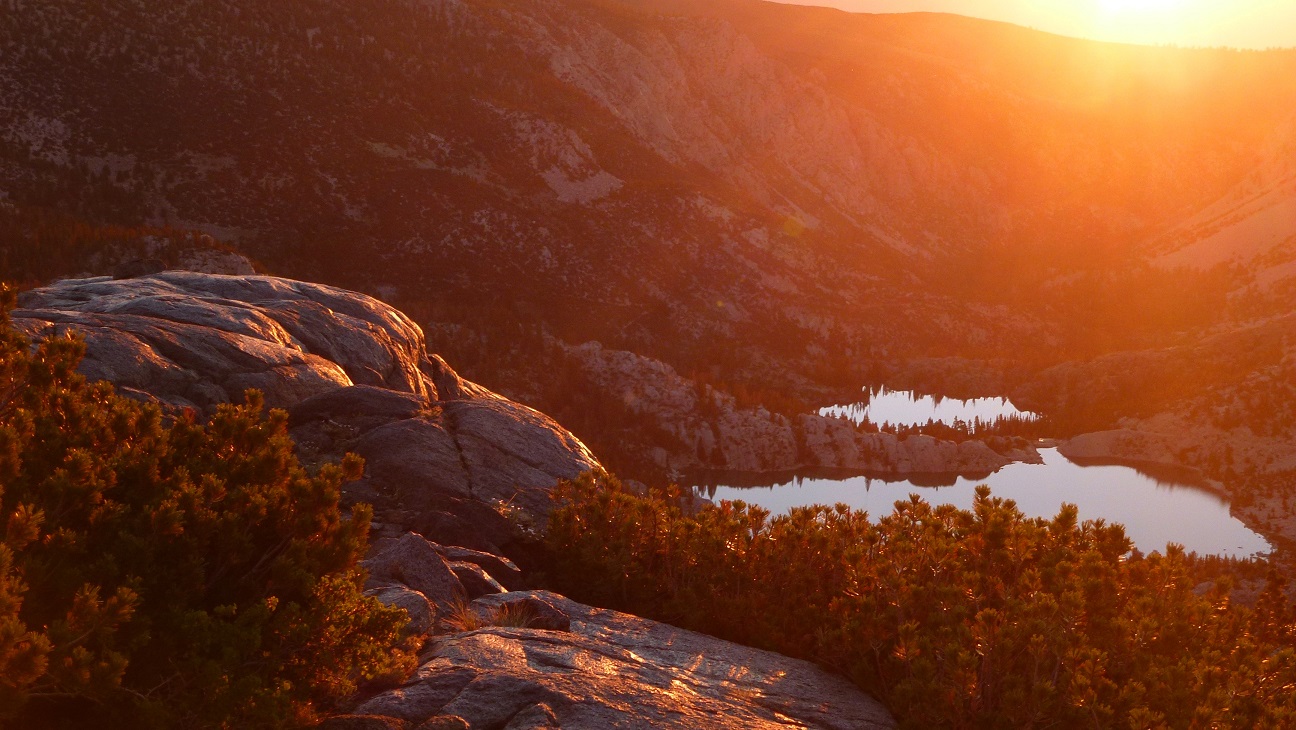
Big Pine Creek Trail was relaxing and easygoing, gaining elevation ever so slightly. It serves as a great trail for beginners, a casual backpacking trip to enjoy the lakes. We reached First Lake at 9:30 pm. The full moon had risen and lit up all the surrounding walls of the valley. It wasn't long after that when we reached Second Lake. From pictures, I knew that this lake was a classic. Its one of the most photographed spots in the Sierra, with its turquoise waters and gigantic north face of Temple Crag rising up to the south. At this time however, the water looked black and Temple Crag looked like the shadow of some gigantic castle.
We had no trouble locating the turnoff to Sam Mack Meadows after Third Lake. Shortly after the turnoff, the trail crossed a stream, then switchbacked southwest. We reached Sam Mack Meadows shortly after 11pm. We would camp here for the night.
The meadow itself, with a creek running right through the middle of it, looked like a bad place to camp. We would likely wake up in the morning with our sleeping bags drenched with condensation. After a few minutes of searching, we located some soft, sandy areas on the immediate north side of the meadow, and set up our bivys there.
Shortly before sunrise the next morning, we headed off towards the Palisade Glacier. We had no trouble finding the well ducked use trail out of Sam Mack Meadows. Upon gaining a ridge above Sam Mack Meadows, we made it just in time to enjoy an alpenglow off the Palisades.


The trail vanished at 11,800 ft, and we took off across slabby rock, running parallel to the north side of Mt. Gayley, finally coming to a saddle (12,360 ft) where we obtained a grand view of the Palisade Glacier.

Palisade Glacier

From the saddle, contour southwest on the glacier, paralleling a prominent ridge of Mt. Sill. While contouring, look for an obvious class 3 chute that heads up towards the left. Climb to the top of this chute, topping out at the widely known "Glacier Notch."
We ended up contouring on talus instead of dropping down onto the glacier. This turned out to be a bad mistake. The talus was very loose, and we had to exercise extreme caution as everything would move. It was very slow going. Eventually we contoured to meet the glacier, and donned crampons.

The glacier was easy, sloping at 30 degrees at the most. There was one small crevasse that we easily stepped over


semi-loose class 3 chute to Glacier Notch

North Couloir from Glacier Notch (13,150 ft)

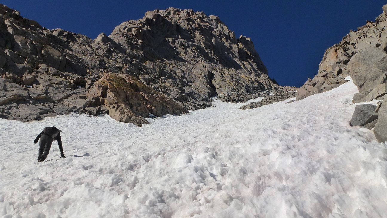
From Glacier Notch, we headed up the North Couloir. We quickly realized that climbing up through the snow was not going to work out. There were several suncups, all frozen and razor sharp, cutting our legs with each step. We climbed up to some rocks on the left side of the couloir, and contoured up fun class 3 rock with a few low class 4 sections. The North Couloir ended at a notch between Mt. Sill and Apex Peak, which I will refer to as "Sillpex Notch."


From Sillpex Notch (13,750 ft), climb slightly up to the left to gain a view of a prominent ledge heading west. Traverse across this exposed ledge. When it ends, scramble 45 ft up some class 4 rock.
view of the ledge from slightly above Sillpex Notch

The ledge turned out to be exposed, but consisted of easy class 2-3 climbing on nice, solid rock. The class 4 section felt more like strong class 3, made up of solid holds with ample footroom.
looking back down from the top of the class 4 section


From the top of the class 4 section, we turned a sharp left and climbed up an prominent class 2-3 ridge. Rock quality was very nice and solid. The ridge took us straight up to the summit, which was composed of flat cracked slabs. It was an excellent gathering place for a large group of climbers. The views were truly spectacular, Just as Secor described it.
View northeast from summit (14,153 ft)

South

Southeast


panorama south

West along the Palisade range

We spent about 30 minutes on the summit taking in views, then descended back down towards Sillpex Notch.
Descending above class 4 section

Apex Peak is basically an outcropping on the north side of Sillpex Notch. It seems that every bump with at least 50 ft of prominence in the Palisades has a name. Although USGS does not consider Apex Peak a true peak, mountaineers do. Therefore, it must be climbed! Because the Palisades are composed of such unique and striking geography in relation to the rest of the Sierra, seemingly insignificant points may have unexpected highlights of their own. Apex Peak was one of these points.
Apex Peak from Sillpex Notch

The climb to the summit of Apex from Sillpex Notch took no more than 5 minutes. It consisted of an exposed summit block that required a fun class 3 move. The highlight of Apex Peak was the view towards North Palisade, displaying numerous towering peaks and bergschrunds. This spectacle could not be seen from Sillpex Notch as the prominent face of Mt. Sill blocked it from view.
Tommey on summit block

view southwest

descending back down the North Couloir

It was still pretty early in the day when we got back to Glacier Notch. We decided to climb Mt. Gayley via the popular "Golden Brick Road" route, which follows a prominent southwest ridge. The route got its name from a yellowish band of rock that spans the length of the ridge.
Gayley's Golden Brick Road route

While appearing loose from its base, the route turned out to be highly enjoyable. It consisted of fun class 3 climbing up excellent rock. There were a few sandy sections which felt really good on our feet. Routefinding was not an issue as it was easy to stay on the ridge.
flowers at 13,200 ft on the Yellow Brick Road

Middle Palisade

looking back at Mt. Sill

celebratory summit shot

View northeast from summit

After signing the summit register (the only one we found that day), we descended back down to Glacier Notch. A group that had just climbed the famous Swiss Arete (class 5.7) of Mt. Sill was descending the North Couloir. They told us that their route had been highly enjoyable, noting some 5.8 moves they had encountered. Our groups descended the chute below Glacier Notch a few people at a time to avoid knocking rocks onto climbers below.
looking down from glacier Notch

base of Palisade Glacier

The glacier was now softened by sun, and it was easily climbable without crampons. Tommey and I glissaded some of it, being careful to avoid a bergschrund.
Because of the loose rock we had encountered at this section earlier, we dropped down into the bowl instead of heading directly for Gayley Saddle. When we reached a spot below the saddle (where most would recommend climbing up to it and retracing our steps back to the use trail), we continued down the bowl, thinking we would eventually run into the use trail. The terrain consisted of loose rock followed by small sections of undulating compacted sand. The last section of sand before running into the use trail was so steep that it forced us to slide down a 20 ft section on our butts, using hands for balance. In retrospect, I recommend climbing back up to Gayley Saddle instead of continuing down the bowl.
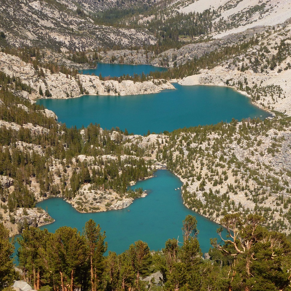
view of Big Pine Lakes from use trail

Shortly after attaining the use trail, we found ourselves back at Sam Mack Meadows. It was still pretty early in the day and the weather was very pleasant, so we stopped at the meadow for half an hour, packing up camp, relaxing, and soaking our feet in a creek.
Sam Mack Meadows

Mt. Sill from Sam Mack Meadows

The hike out was very relaxing and enjoyable, with scenery that blew us away.


Third Lake and Temple Crag


Second Lake

nice views of Kid Mountain (left) and Big Kid Mountain (right)


Final Stats
22.3 miles
7,800 ft gain/loss

Weather Forecasts
Trailhead
Third Lake
Sam Mack Meadows to Palisade Glacier
Mt. Sill (Mt. Sill has an elevation of 14,153 ft. Keep in mind that this forecast is for 13,228 ft)
Peakbagger Pages
Mt. Sill
Apex Peak (Note: The person who entered this peak placed it in the wrong spot. Apex Peak is the highpoint to the northwest of the placement)
Mt. Gayley
Summitpost Pages
Mt. Sill main page
Mt. Sill North Couloir page
Mt. Gayley main page
Mt. Gayley Yellow Brick Road page
Other
High Sierra Topix message board
Inyo National Forest
Best description I’ve found to date. Thank you
ReplyDeletethanks, very useful!
ReplyDelete