
June 9-10, 2012
"Middle Palisade? What the heck is a Middle Palisade?"
I had received an email from Tommey, asking if I was up for climbing Middle Palisade in the Sierras on an upcoming weekend. At that time, I had only been in the High Sierra two other times in my life, and didn't know much about it let alone its peaks, so I quickly got onto Google and fired away. After a few hours of searching, I decided to go for it. This peak and its mileage did not look difficult. The climbing itself was class 3 at the most. It also seemed to be a very popular climb, judging by all the masses of trip reports I had managed to find.
Getting to the trailhead: From Big Pine off of Hwy 395, turn west onto W. Crocker Street, which will soon turn into Glacier Lodge Rd. Travel 11 miles to the end of this road. This is the day use trailhead. The overnight parking lot can be found a half mile back on the north side of the road.
Trailhead coordinates (lat/lon): 37.125311, -118.437484
Tommey and I pulled into Big Pine Creek Trailhead late Friday night. Because the sun was going to come up in a few hours anyway, we ended up sleeping in the car instead of setting up our bivys.
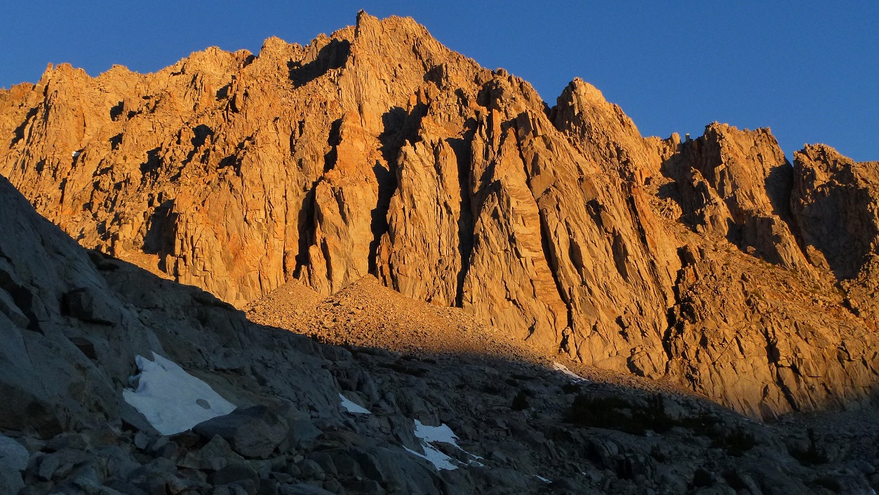
We set off from Big Pine Creek Trailhead (7,800 ft) on Saturday morning at 5:30 am, just in time to catch a spectacular alpenglow cast on Norman Clyde Peak.

A few moments later, another trail branched off of the main one. This was our turnoff for Big Pine Creek South Fork. The South Fork Trail headed southwest, winding through a valley for a short distance, then switchbacking gently up a steeper rise at the end of the valley. At the top of these switchbacks, there were some nice flat areas suitable for camping. We attained our first detailed view of Middle Palisade from there. Convinced that Middle Palisade was going to be a very easy climb, we decided to plop down there for a bit, enjoy the view, and take it easy. After about 20 minutes, we continued on our way.
views from switchbacks


flat areas above switchbacks

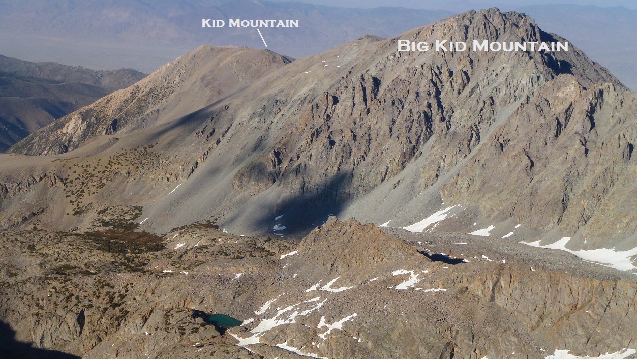
Middle Palisade and its subpeaks

A few moments later we came upon Willow Lake (9,550 ft). This lake, located 3 miles from Big Pine Creek Trailhead, was composed of mostly marsh- a perfect mosquito breeding ground. There were nice campsites surrounding the lake, but they would probably be best used later in the season when the Willow Lake air force has diminished. We hurried past Willow Lake as fast as possible, swatting mosquitoes here and there.
above Willow Lake


The trail continued for 1.2 mi after Willow Lake, eventually petering out and ending at Brainerd Lake (10,250 ft). It would be all cross country from here.
view of Big Kid Mountain, 0.4 mi before Brainerd Lake

Brainerd Lake


After filling up on water at Brainerd Lake, we began climbing a slope to the west of the lake, heading towards Finger Lake 0.4 mi away. After ascending a few hundred feet, Tommey let out an "oh shit!" after reaching into his bag and realizing his phone was missing. Thinking that he had dropped it somewhere above Brainerd Lake, we hiked back and looked all around, descending back down to the lake. After 30 minutes of searching, we gave it up and began climbing back up when I heard Tommey utter another "oh shit!" He had reached into his pocket and felt the phone, where it had been the whole time. Not wanting to waste any more time, we began ascending again.
above Brainerd Lake

There were three ways to get from Brainerd Lake to Finger Lake. Once about 150 ft above Brainerd Lake, we gained a view of three ledge systems heading southwest. According to trip reports, all of them worked involving class 2 terrain at the most. We ended up picking the topmost one.

above Brainerd Lake

Upon reaching a small ridge with a view of Finger Lake, we turned a sharp south, heading towards a outlet on the lake's north side. Several rocks rose out of the water at the outlet, allowing us to cross it and walk over to the west side of Finger Lake.
Finger Lake was a true Sierra gem. Its turquoise-colored water sparkled in the morning sun. A slight breeze came through the area, cooling us off. Several good camping areas lined the western side of the lake. Best of all, this area served as the front row seat for spectacular views of towering peaks above.

We ascended the rocky slopes west of Finger Lake for about 100 ft, then contoured along the west side of Finger Lake, gradually ascending along the way.


Pretty soon, Finger Lake was behind us, looking like a insignificant puddle amid all the large piles of rock surrounding it. We continued to ascend, contouring southwest. Our attention turned now to the big mass of rock laying ahead that was Middle Palisade.

Upon reaching the Middle Palisade Glacier, we aimed for a prominent moraine/rib feature that extended from the mountain itself, separating Middle Palisade Glacier into two sections. The glacier crossing was nothing serious. We had brought ice axes and crampons, and probably didn't need to use them, but did anyway because we had lugged them up all this way and wanted to put them to some purpose.

We got onto the rib, which turned out to be composed of loose scree, and slogged a short distance to the base of Middle Palisade's Southeast Face.
ascending the rib

Now the trick was to locate the correct ascent ramp in order to get onto the Southeast Face. There were two options here. The standard route was to ascend a small part of the glacier left (south) of the rib and locate a class 3 ramp which will ascend into a chute. This route, while being the easiest, has proved troublesome during certain times of year due to a large bergschrund opening up to the point where it would become difficult to pass or dangerously unstable. The alternative (Red Rock Route) was to drop right (north) from the rib and pick up a chute containing several chunks of red rock. Both the standard and alternative routes would merge into one above a gendarme a few hundred feet above the glacier.
After studying the face for a little bit, we decided to go for the standard route. Just as we were approaching the class 3 ramp, two people could be seen descending it. When they got to us, the mentioned that they had turned around below the summit, noting that it was too icy to continue. They however did not bring their ice axes and crampons, and noted that they probably would've gone for it if they had those tools. We wished eachother safe climbing, and continued on our separate ways.
Tommey and I sat at the base of the ramp, contemplating whether or not we should keep going. Our main concern was the time. It was already 2:30 pm, and our elevation was 13,000 ft. After a few more moments of sitting there, we decided that we were wasting valuable time and began climbing up the ramp.
Once above the ramp, our ascent chute was pretty obvious. It contained a whole lot of great class 3 climbing on solid rock. We would simply follow this chute up until it ended right below the summit blocks.


stairway to heaven


looking East

At 13,300 ft, we climbed above the gendarme that separated our route from the Red Rock Route. This gendarme would be a useful reference of which chute to descend on the way down.


I found myself enjoying this route a great deal. The rock was blocky, excellently solid, and composed of great holds. Occasionally we would kick down small bits of shale that lay on the blocks, but nothing big enough to hurt someone below. We did not encounter any climbing that surpassed a class 3 rating. As our elevation increased, we were treated to increasingly nice views. There were a few patches of ice here and there, but nothing that caused concern. Our ice axes and crampons remained inside our packs.


As we climbed, we eventually noticed two prominent notches above us. The left notch was the one to aim for, as Middle Palisade's summit lay just to the left of it.

Upon reaching the notch, we realized that we were not supposed to climb all the way up to it, but to begin contouring left about 50 ft below it. We reversed our steps, then started up the correct route.
looking northwest from above the notch

ascending last 50 ft to summit

As we rounded a corner onto the summit at 4:45 pm, our jaws dropped as a expansive view appeared out in front of us to the west. There were miles and miles of mountains spread out like a giant quilt. The lighting at that time of day was phenomenal. It took me a moment to realize that I was standing at the summit of my first Sierra fourteener. I thought to myself, "this was what climbing is all about!"


Middle Palisade's highest point was a small pinnacle block that jutted out amid several other similarly shaped blocks. There was very little room to stand on it, so we both ended up sitting on it. We both poked around for the summit register, but found nothing. [update: A new register had been placed by the Sierra Club later that year]
Tommey on Middle Palisade's highpoint

looking back towards Finger Lake

After our moment of hurrah at the summit, our thoughts turned to descent. It was now 5:10 pm, and the sun was dropping fast. Time to boogie.


We made quick time down the couloir, reaching the rib by 7:20 pm. A great view of Mt. Sill and Mt. Gayley appeared to the north.

In order to avoid getting back onto the Middle Palisade Glacier, we took a different route back from the rib. We continued down the rib to the edge of a dropoff, then headed north to meet the boulder field we had used earlier to traverse to the glacier. From there, everything was familiar again.
alpenglow on Big Kid Mountain, 8:05 pm

As we got within 800 ft above Finger Lake, it started to get too dark to see, and our headlamps clicked on. Descending this bouldery terrain seemed to take forever even though the lake was right below us. As we descended to a point 500 ft above Finger Lake, Tommey said that he felt it was too dangerous to continue, and wanted to look around for a spot to bivy for the night. It would be very likely for one of us to twist an ankle on the way down. I took a look down at the lake which seemed so close, and urged him to continue. "Its only 500 more feet on class 2 rock, and then we're home free. All it will be after that is an easy descent to Brainerd Lake, then a trail all the way back." Despite my attempted persuasion, Tommey remained convinced that we shouldn't continue. He was determined to bivy.
Not wanting to descend alone, I had no other choice but to also bivy. We searched around for some time, but did not find any spot that could comfortably fit two people, or even one person. Eventually we decided to shelter behind a large leaning boulder that would at least protect us from the wind. The ground below it was much like everything around us- rocky. We laid down as comfortable as possible, and spread out Tommey's space blanket over both of us.
From what I could remember afterward, it didn't turn out to be that bad of a night. Though the air temperature dropped into the high 20s, the space blanket trapped our body heat well, and it was quite warm. I woke up probably 4 times that night, shifting away rocks that were poking me in the back. We woke up at sunrise actually feeling refreshed, just in time for an alpenglow.


descending to Finger Lake

morning light on Buck Mountain

Upon reaching Finger Lake, we ran back into the two guys we had met descending Middle Palisade on Saturday. After discussing our routes for several minutes, it turned out that they had turned around 200 ft below the summit after taking a false chute, so that probably explained their icy conditions. We stayed for a few more moments, chatting about other Sierra peaks, then continued on our way down.
views during descent


We reached the trailhead at 8:30 am without a hitch, congratulating eachother on our successful ascent of Middle Palisade.
Final Stats
12.5 miles
7,000 ft gain/loss
note: Map error; "Southeast Face" should be "Northeast Face"

Weather Forecasts
Trailhead
Finger Lake
Middle Palisade (Middle Palisade has an elevation of 14,012 ft. Keep in mind that this forecast is for 12,992 ft)
Peakbagger Pages
Middle Palisade
Summitpost Pages
Middle Palisade
Northeast Face
Other
High Sierra Topix message board
Inyo National Forest
Great pictures I can't wait to see it in person!
ReplyDeleteWhat permits were required for this? Do you need permits to go car-to-car in one day?
Thanks
Overnight permit from Inyo if you plan to overnight, but none required for dayhiking
DeleteI am going this weekend and was wondering if there be any need at all for climbing shoes while climbing the chute?
ReplyDeleteNo climbing shoes needed if you do the Red Rock Route which is all class 3. The standard route is now class 4 due to the glacier melting out.
Deleteexcellent trip report. very helpful, im doing this in 2 week and will camp at finger lake
ReplyDelete