
July 13-15, 2012
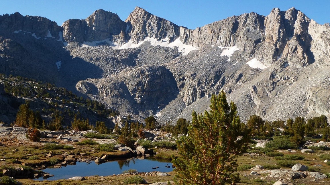
Mt. Goddard is a gargantuan mass of black rock located near the western end of the Goddard Divide in the central High Sierra. Its dominant stature allows it to be seen from most of the high Sierra, and can even be seen from up to 100 miles away on a clear day.
Our plan was to start the hike from South Lake Trailhead aka Bishop Pass Trailhead (11,940 ft), hike 6 miles to Bishop Pass (11,940), drop 6.8 miles down through Dusy Basin into LeConte Canyon (8,760 ft), take the John Muir Trail 7.9 miles north through LeConte Canyon to Muir Pass (11,980 ft), and continue 2.4 miles to the outlet of Wanda Lake (11,440 ft). From there, we would cross country it southwest to Mt. Goddard via the historical Starr's Route.
| Peak | Elevation | Topographic Prominence | Summit Coordinates (lat/lon) |
|---|---|---|---|
| Mt. Goddard | 13,568 ft | 1,588 ft | 37.103548, -118.71946 |
| "Sidetrip Peak" | 13,040+ ft | 172 ft | 37.107341, -118.712072 |
Getting to the trailhead: From Bishop off Hwy 395, head west on West Line Street (Hwy 168). Continue 15 mi, then turn left onto South Lake Rd, which will be clearly marked with a "South Lake" sign. Continue 7 mi to the end of this road.
Trailhead coordinates (lat/lon): 37.169338, -118.565850
I had wanted to climb Goddard for a long time, ever since I read about it in a trip report on Summitpost in 2006. On Friday 7/13, Tommey and I pulled into South Lake Trailhead late at night. On the way there, we were constantly stopping to take photos of big thunderstorms near Bishop. We decided to hike in for an hour or two and bivy below Bishop Pass.
storms near Bishop


The hike in was very nice. The fresh air and cool temperatures were a welcomed respite from the loud, bustling cities in SoCal. Bivying below Bishop Pass near a creek turned out to be a bad idea. All the moisture from the previous day's storms had settled into the valleys below the pass which had resulted in lots of condensation overnight. I turned over in my sleeping bag just before sunrise and a bunch of cold water splashed into my face. Tommey's bag looked like it came straight out of the creek. We decided that there was nothing we could do below the pass since the sun was going to take another two hours to get over the mountains, so we ate a quick breakfast and decided to dry out the bags on the other side of the pass in full sunlight.
Bishop Pass turned out to be bone dry and about 15 degrees warmer.
view of Giraud Peak from Bishop Pass

From Bishop Pass, it was a 6.8-mile hike through Dusy Basin and down to LeConte Canyon. I was surprised at how much elevation we dropped as we went from just under 12,000 ft to 8,700 ft. We both knew those switchbacks were going to be very demanding on the way back up.
heading into Dusy Basin


We decided to take out the sleeping bags to dry about 2 miles after Bishop Pass. I went down to a small tarn to fill up on water and take some pictures.


lower Dusy Basin- almost to the beginning of the switchbacks into LeConte Canyon

looking into LeConte Canyon


We reached the bottom of LeConte Canyon, hiking through a lush green forest with breathtaking views. The temperature in the canyon was around 70 and rising. From the canyon, it was an easy 7.9 mile hike up the JMT to Muir Pass (11,955 ft). The upper portion of this hike below the pass was very interesting, containing a lake or creek at what seemed like every turn in the trail.


At Muir Pass, I munched on some crackers for some quick energy as we talked to a group, with each person carrying what looked like 60 lb packs. They said that they were doing the North-South Lake loop in a week and wanted to make the most of it, so they were carrying things such as tennis rackets, soccer balls, and guitars. We passed by another group of three who asked us where we were headed to. When we mentioned Goddard, their mouths dropped and they strongly warned us against trying to summit Goddard that day. This got us thinking, but the thoughts vanished as soon as the dark face of Mt. Goddard popped over a ridge and came into plain sight.

From Muir Pass, we hiked a little over 2 miles to the outlet of Wanda Lake, and dropped our packs at a sandy spot. This would be our camp for the night.
view of Wanda Lake from Muir Pass

Wanda Lake


We quickly had a bite to eat, put the packs up on a rock so that marmots wouldn't get to them, and set up the bivies so that they would be ready to crawl into when we got back. We each brought a water bottle and a few energy bars for the remaining portion up to the summit, which was 5.4- miles round trip from camp. We left camp at around 3:40pm.
From camp, a 300 ft ridge obstructed our view of Goddard. We crawled onto the top of the ridge and got a view of the canyon we had to descend into in order to get to the base of Goddard. It looked like a long descent. We descended about 300 ft and checked the time. It was 4:10. We sat down and considered our options. The mountain still looked far away. There was the thought of going back to camp and coming back to summit the next morning, but if we did that, we wouldn't be able to hike out in time. We tried to figure out the elevation gain to the summit in order to get a better scale. I recognized the shape of the highest lake in the valley from Google Earth and knew that it was at about 11,200 ft. We checked the map to confirm. The area we would drop down to looked like it was 200 ft higher than the lake. The summit of Goddard was just over 13,500 ft, so the elevation gain had to be around 2,100 ft from the valley (I later found that it was 2,400 ft). We decided that this wasnt too bad and decided to give it a go. We estimated summiting at around 7pm and getting back to camp at around 11pm. I didn't care if it got dark. The route was not technically difficult (all class 2) as long as we got back to the base of the mountain before dark. Tommey said that he would rather crawl back to camp in pitch black rather than hiking back to South Lake the next day with the thought of failure.
view of the valley as we descended into it

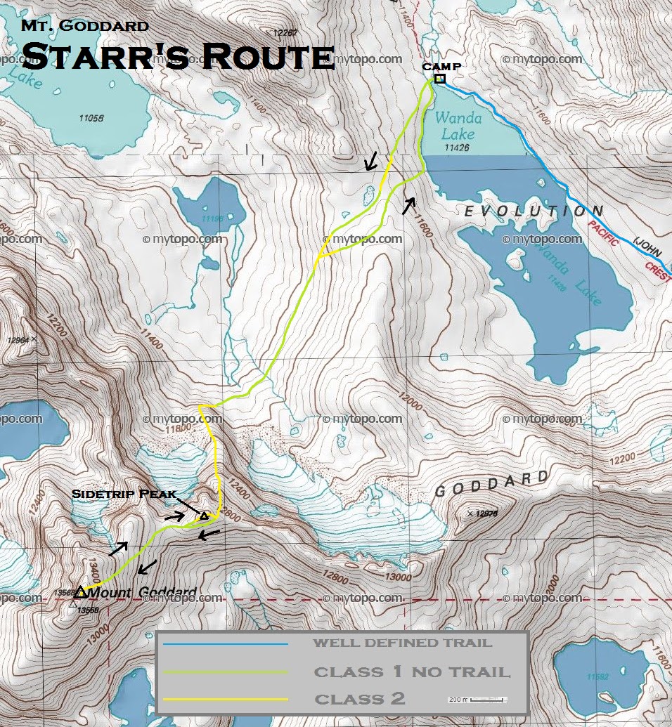
Starr's Route

The hike to the base of the mountain turned out to be shorter than we thought. We arrived at the base of the mountain at 4:30pm, 20 minutes faster than predicted. The obvious ridge we were supposed to scramble up stood out like a monster. We sloshed across a snowfield and started up the ridge. After climbing up about 60 ft, we were confused as the route steepened to class 3+ with slippery blocks. This was something we surely would not be able to descend at night without a rope. We were both sure that we were supposed to take the ridge, recalling several trip reports containing a clearly drawn line up the ridge. We descended back to the snowfield and decided to try another section further down the ridge. This turned out to be more of the same. We were really getting dismayed. I looked west to where the ridge ended, and saw what looked like a big scree field heading up the mountain. We decided that the ridge crest was not feasible due to the amount of daylight we had. We could get up, but now down. When we got to the scree, we saw that it went up and hit a notch. What was on the other side of the notch could not be seen as it was hidden by more hills of scree. It was 5pm. We decided to climb to the notch. It couldn't hurt. We both decided that if the route at the end of the scree was not doable, we would turn back. Upon reaching the notch, Tommey let out a loud scream of joy. We could see the obvious route. In another few hundred feet, a clear system of easy ledges stretched from the scree to access the ridge, which also looked straight forward, heading to another notch up on the Goddard Divide on the left (east) side of Sidetrip Peak. We could recognize that notch from previous photos, and our spirits soared.
We gradually advanced up the ridge, working our way up and around a series of ledges. There were cairns here and there, but they kept misleading us. We used up about 20 minutes of time in a off-route class 3 chute after being mislead by a giant cairn, which we kicked over afterwards.
climbing the ridge


After a few more ledges and ramps, we came to the final large ramp which lead up to the Goddard Divide at Point 12,910 ft.

The views south from Point 12,910 ft were awesome! Even though it was already 6pm, the summit was in view and we decided to make a run for it. All we now had to do was traverse along the backside of Sidetrip Peak, and walk up the remaining ~700 ft of talus slope to Goddard's summit.


Goddard's summit in view

more ascent views


The talus slope was nothing tricky- just one foot in front of the other. We summited just after 7pm- a near bulls eye on our estimated time.
looking northwest from Goddard's summit

south

-

Tommey on the summit

We signed the register, took a few pictures, high fived, and enjoyed the views for a few more minutes before descending around 7:20pm. The views were out of this world, and I wished we had more time to spend on the summit.


On the way back down, I decided to go over Sidetrip Peak instead of contouring along its scree-covered slopes. The ascent was mostly class 1.

views while descending the ridge


We got below the ledges right as it became too dark to navigate without lights. We took out our flashlights at the scree about 200 ft above the base of the mountain. As we reached the bottom of the scree fields, all that was left was hiking across the valley, over the ridge that separated the valley from Wanda Lake, and descending to camp. Getting across the valley was fairly simple. The only thing we had to watch out for were the many rivers which flowed from the snowfield above. We began climbing up the ridge that separated us and camp at around 10pm. The direction felt a little off. We seemed to be going straight up the side of the ridge, not gradually contouring up left like we were supposed to. Whenever we would try to go left, the rocks would cliff out. We reasoned that we were probably going the right way but the terrain and darkness were throwing off our sense of direction. Finally, we came over the crest of the ridge and started down the other side. A vague dark shape of a lake came into view, barley recognizable in the darkness. Something didnt feel right. The terrain was supposed to be sandy at our campsite, not rocky like it was here. I thought that we might have gone too far east and came out at another lake further down the canyon. Getting back would mean locating the JMT and hiking another half mile back uphill. We looked around for the JMT but could not find it. The map showed that it ran right along the west side of the lake that we thought we were standing at. Suddenly, Tommey had an idea. If our sense of direction was correct and we were not going left enough up the ridge, we must be on the opposite side of Wanda Lake from camp. There was a little island about 500 ft away that matched an island on the map. Bingo. The map indicated that camp was roughly a half mile away, so we went back up the ridge a little ways and contoured northeast. Sure enough, as soon as we descended again, the bivies came into view. It was just after 11pm. We laid down and fell asleep in a matter of minutes.
We woke up just after 4am, somewhat refreshed from sleep. The night was warm and pleasant in the high 30s, much better than it was the previous night below Bishop Pass. A crescent moon rose over Mt. Darwin as we cooked breakfast and prepared for the long hike out. We relaxed until 6am before starting the hike. As we walked around Wanda Lake, the sun rose and dazzled the surrounding mountains in awesome light.


back at Muir Pass

The hike back down LeConte Canyon from Muir Pass was very pleasant, but the thought of the 3,240 ft gain of switchbacks up to Bishop Pass kept us from moving too fast and using up all our energy.


As it turned out, the switchbacks weren't too bad as long as we kept at a slow and steady pace. The annoying thing was the heat. Both of us stopped several times to splash our faces in several creeks.
At last, we finally arrived at Lower Dusy Basin, and jumped into a small lake to cool off. It was the best feeling ever.

We got back to Bishop Pass just after 1pm. All that was left now was an easy 6 mile hike back to the trailhead with the usual stunning views.


Final Stats
51.6 miles
12,430 ft gain/loss

closeup of Starr's Route
Weather Forecasts
Trailhead
Bishop Pass/Dusy Basin
LeConte Canyon
Goddard/Sidetrip Peak
Peakbagger Pages
Mt. Goddard
Sidetrip peak
Summitpost Pages
Mt. Goddard
Other
High Sierra Topix message board
No comments:
Post a Comment