
September 3, 2016
Mt. Williamson's northeast ridge (see map) stands out like a massive monster belching out of the Sierra Crest and into the Owens Valley. It is known by some as one of the most physically demanding single ridges in the Sierra, starting from an elevation of 5,800 ft in the Owens Valley and undulating up to the 14,375 ft summit of the second highest mountain in California. This ridge had always fascinated me, seeing it from US-395 countless times every summer. It is the far lesser climbed of two classic routes up Williamson, with the other being the Long Twisting Rib, which joined up with the northeast ridge not far below Williamson's summit. Williamson's standard route, the west face, involved a several thousand foot slog up a barf chute of loose rock which had absolutely zero appeal to me. It took several years to find a partner who was also willing to climb the northeast ridge, but eventually that lucky time came.
| Peak | Elevation | Topographic Prominence | Summit Coordinates (lat/lon) |
|---|---|---|---|
| East Horn | 14,074 ft | 197 ft | 36.6620, -118.3037 |
| West Horn | 14,140 ft | 197 ft | 36.6613, -118.3055 |
| Mt. Williamson | 14,375 ft | 1,679 ft | 36.6558, -118.3110 |
Getting to the trailhead
Trailhead coordinates (lat/lon): 36.7271, -118.2789
It was roughly 2:15am as Gavin and I dragged ourselves up, fiddling with a few bits of gear which included an alpine rack and 60m rope, before setting off. From Shepherd Pass Trailhead (6,320 ft), we hiked 1.5 miles along a series of dirt roads until our last road dead ended a few hundred feet north of Shepherd Creek. We managed to find a crossing spot (6,170 ft) that was not too brushy, and began slogging up the other side and onto the toe of the ridge. From 6,170 ft to 9,900 ft, the ridge was characterized by steep sandy slopes littered with pinyon pines and desert shrubs. This part of the ridge was pretty much a dragging sufferfest which went on for hours, where as our feet sunk deeply with each step up, we were rewarded with another foot or two of sandy slope which became visible in our small circle of headlamp light.
Are we having fun yet?

We were treated to a pretty magnificent sunrise at 9,800 ft.


Shortly after sunrise, I began to feel nauseous, and soon felt a headache coming on. After 20 minutes of this, it was too painful to bear and I had to lay down and take a nap. After another 20 minutes, I felt a little better and we continued on. This was cut short 15 minutes later as another strong wave of nausea hit me, and I had to lay down and sleep for over an hour, trying to unsuccessfully vomit. Upon waking up, I noticed that the nausea was gone, but the headache was still there (though not as bad). We were now behind schedule, and discussed whether it was worth it to continue. Both of us agreed that the first part of this ridge was nasty enough that we would not want to do it again tomorrow, so in the end I said that I would like to continue. This was a good choice, as I gradually improved over the next few hours. I sat there feeling really puzzled why this sudden unexpected sickness had come over me, and would figure out why several hours later.
Due to our lost time, we decided to somewhat cheat and bypass the next section of ridge which consisted of several crumbly towers. We bypassed them on their south side, aiming for a large scree ramp to the west, glad to be out of the stubborn shrubs.

The scree, not to any great surprise, also sucked. By the time we finally hit the ridge at 11,000 ft, not far north of a prominent V-notch, we finally basked in the glory of nice solid rock which we wouldnt sink into. The main ridge was very exposed and composed of several large class 4 blocks. It was a beautiful ridge, and I felt like I was walking on air.


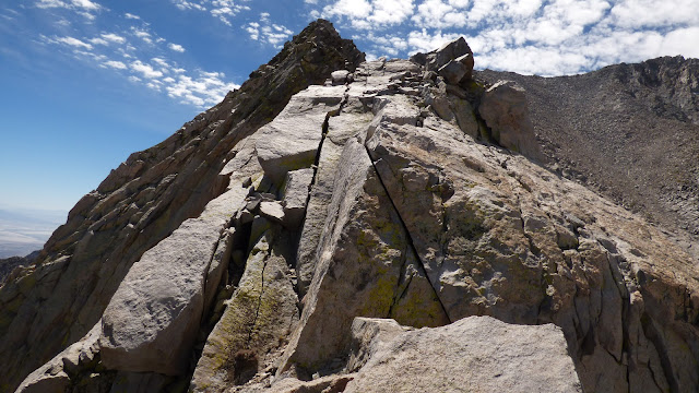

Just before the V-notch (11,400 ft), our ridge cliffed out and we were forced down along its east side. Gavin found a rap sling and downclimbed an awkward 10 ft 5.6 chimney to a large ledge while I headed back along the ridge for about 50 ft, locating a super exposed class 4 ledge system which I traversed over to Gavin's ledge. From there it was an easy class 3 walk to the V-notch.
Gavin starting down his awkward chimney

After the V-notch was a lot of class 3 terrain. We stayed slightly on the west side of the ridge on generally good rock. I kept an eye out for a picturesque arch mentioned in a previous report.


boo yah!
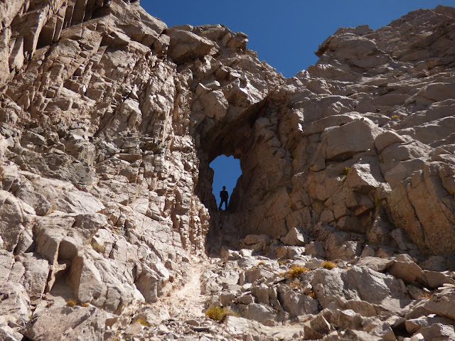
After checking out the arch, we clambered back onto the ridge, finding ourselves at the first of two large scree slopes. This first scree slope ran from 11,940 to 12,400 ft, eventually bringing us to the start of another climbing section.
first scree slope

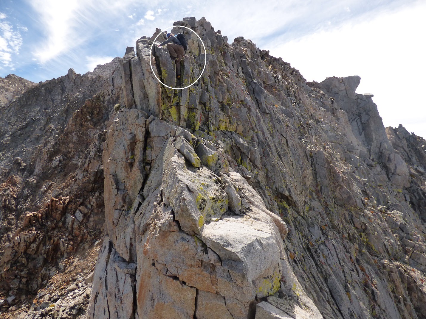
The second climbing section was characterized by a series of rotten class 3-4 towers. For the first three of these, we stayed as close to the ridge as possible, climbing up and over each tower on crumbly (but not horribly dangerous) rock. Much of this was fairly enjoyable climbing. The fourth tower was very recognizable, crowned with one enormous boulder. We tried to go over it, but saw a sheer drop on the other side. Climbing down a western rib for a hundred feet, we descended some class 4 around a rap anchor, weaved between a few crumbly gendarmes, and found ourselves at the start of the second scree slope, which ran from 12,800 to 14,000 ft.
second climbing section


climbing around the fourth tower


second scree slope (ugh!)

We stopped for a break at the base of the scree. I pulled out one of my two water bottles and realized the water inside was filled with floating bits of mold! This was why I had been sick that morning. It was only when I had started drinking from the other bottle that I had began feeling better. I disgustedly dumped out the poison water, noting that this left me with a quarter liter. Just great. I was already rationing water for the last 4 hours, and the route ahead was long. A lack of water also meant that I could not eat because it would lead to even more dehydration. Let the fatigue games begin.
Little by little, we dragged our tired feet up the scree slope, glad to at least be gaining altitude at a fairly fast rate. At one point I thought I could hear a rapid drumbeat, thinking "uh oh, Im starting to hallucinate," but was relieved upon realizing that it was just Gavin playing music to take his mind off the slog.


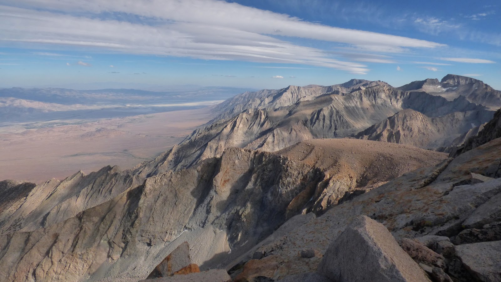
The scree slope deposited us just above 14,000 ft at the summit of East Horn, which began the third climbing section.
views from East Horn


summit block (right)

We descended the west ridge of East Horn for roughly 200 ft of distance of class 3, coming up to an impasse. Looking down north, we spotted the top of the crux chimney mentioned in reports. We carefully squeezed down this 15 ft feature, which felt like 5.5.
looking down the 5.5 chimney

Gavin downclimbing chimney


The chimney deposited us onto a gigantic ledge covered in sand and gritty rock. From here, I knew that some others had headed in a horizontal line west along some slippery slabs. Upon closer inspection, we found these slabs to be glazed with ice, and decided against them.
We now looked down to the north, and saw that the next cliff ended in a cruddy but climbable chute which would connect to West Horn's east face. Since we did not want to downclimb this next cliff, I finally dumped out the rope and set up a 70 ft rappel.
looking down into the chute

Gavin in mid rappel

After finishing up the rappel, we descended another ~100 ft of crud, traversed around a rib, and finally found ourselves on West Horn's class 3 east face. We made short work of this and were soon up and over West Horn, watching a feeble sun hanging low over the horizon.
going around a rib after rappelling

climbing West Horn's east face

clouds over Center Basin

views from West Horn


From West Horn, we descended a large class 3 ramp on the north side of its west ridge, eventually reaching a small amphitheater formed by the west ridge and a large rib jutting off to the north. A short climb up to a small notch in this rib was the key to bisecting it.


view southwest from the notch

west side of notch

After the notch, the ridge became one large slab of rock with a near vertical face on its north side. There were multiple routes up this slab ranging from class 3-4.

As tired as I was, the vivid hues of Sierra sunsets never ceased to stop me in my tracks,


Shortly after sunset, we stumbled onto the summit plateau of Williamson, gasping for air. The next 15 minutes were spent with our heads down, marching up a slog slope to the southwest. We finally reached the summit 20 minutes after sunset and sat down briefly to rest and sign the register.
last....bit

last light on southern peaks

Now we were faced with the long and arduous descent down the west face, through Williamson Bowl, and down the Shepherd Pass Trail. We headed a little ways northwest down the summit ridge, locating a large cairn marking the top of the west face route. Below this cairn was a short class 3 chimney which was easily downclimbed, followed by an almost 2,000 ft descent down the west face barf chute.
class 3 chimney on west face

The barf chute seemed to take forever, especially since it was pitch dark and we could not see how much progress we were making. Sometime around 9pm, we finally reached the boulders of Williamson Bowl, running into and briefly chatting with two guys who were headed up the west face to camp on Williamson's summit.
Soon we came to a lake, where we gratefully filled up our bottles and drank mouthfuls of ice cold water. Since it was somewhat breezy and the air temperature was cold, this had us shivering within minutes, and we continued onward in order to warm up. On and on went the dark boulder fields of Williamson Bowl. Even though the bowl was less than a mile across, it took almost an hour of boulder field weaving to get across it and eventually climb a bouldery slope up to a very broad sandy saddle between Mt. Tyndall and Polychrome Peak. From there, it would be a sandy walk to Shepherd Pass.
At Shepherd Pass, I was once again hit with more nausea, and we stopped briefly to take a short cold nap. After not being able to stand the cold anymore, we began walking, knowing that only 10.3 miles of trail lay between us and the end. Eventually I became so sleepy that I had to lay down again while Gavin continued down. Again, I succumbed to the cold after 10 minutes, and had to begin moving again. For the next few hours, I took a series of 10 minute naps along the trail, eventually feeling better as I lost elevation. I stopped for a brief water break at Anvil Camp, noting several tents strewn out and about. Someone stirred in their sleep in one of them, obviously off in a far better place than the dark trail. On and on I went, up to Symmes Pass, and down endless switchbacks, eventually arriving back around 5am. Gavin was already fast asleep, having arrived 30 minutes earlier. I pulled out my sleeping bag and happily grabbed a few hours of Z's before the blazing desert sun would come scorching up.
Final Stats
21.5 miles
11,000 ft gain/loss

Weather Forecasts
trailhead (6,320 ft)
9,500 ft
12,200 ft
13,200 ft
Mt. Williamson & horns
Peakbagger Pages
Mt. Williamson
Summitpost Pages
Mt. Williamson
Northeast Ridge
Trailhead coordinates (lat/lon): 36.7271, -118.2789
It was roughly 2:15am as Gavin and I dragged ourselves up, fiddling with a few bits of gear which included an alpine rack and 60m rope, before setting off. From Shepherd Pass Trailhead (6,320 ft), we hiked 1.5 miles along a series of dirt roads until our last road dead ended a few hundred feet north of Shepherd Creek. We managed to find a crossing spot (6,170 ft) that was not too brushy, and began slogging up the other side and onto the toe of the ridge. From 6,170 ft to 9,900 ft, the ridge was characterized by steep sandy slopes littered with pinyon pines and desert shrubs. This part of the ridge was pretty much a dragging sufferfest which went on for hours, where as our feet sunk deeply with each step up, we were rewarded with another foot or two of sandy slope which became visible in our small circle of headlamp light.
Are we having fun yet?

We were treated to a pretty magnificent sunrise at 9,800 ft.


Shortly after sunrise, I began to feel nauseous, and soon felt a headache coming on. After 20 minutes of this, it was too painful to bear and I had to lay down and take a nap. After another 20 minutes, I felt a little better and we continued on. This was cut short 15 minutes later as another strong wave of nausea hit me, and I had to lay down and sleep for over an hour, trying to unsuccessfully vomit. Upon waking up, I noticed that the nausea was gone, but the headache was still there (though not as bad). We were now behind schedule, and discussed whether it was worth it to continue. Both of us agreed that the first part of this ridge was nasty enough that we would not want to do it again tomorrow, so in the end I said that I would like to continue. This was a good choice, as I gradually improved over the next few hours. I sat there feeling really puzzled why this sudden unexpected sickness had come over me, and would figure out why several hours later.
Due to our lost time, we decided to somewhat cheat and bypass the next section of ridge which consisted of several crumbly towers. We bypassed them on their south side, aiming for a large scree ramp to the west, glad to be out of the stubborn shrubs.

The scree, not to any great surprise, also sucked. By the time we finally hit the ridge at 11,000 ft, not far north of a prominent V-notch, we finally basked in the glory of nice solid rock which we wouldnt sink into. The main ridge was very exposed and composed of several large class 4 blocks. It was a beautiful ridge, and I felt like I was walking on air.


Just before the V-notch (11,400 ft), our ridge cliffed out and we were forced down along its east side. Gavin found a rap sling and downclimbed an awkward 10 ft 5.6 chimney to a large ledge while I headed back along the ridge for about 50 ft, locating a super exposed class 4 ledge system which I traversed over to Gavin's ledge. From there it was an easy class 3 walk to the V-notch.
Gavin starting down his awkward chimney

After the V-notch was a lot of class 3 terrain. We stayed slightly on the west side of the ridge on generally good rock. I kept an eye out for a picturesque arch mentioned in a previous report.


boo yah!

After checking out the arch, we clambered back onto the ridge, finding ourselves at the first of two large scree slopes. This first scree slope ran from 11,940 to 12,400 ft, eventually bringing us to the start of another climbing section.
first scree slope

The second climbing section was characterized by a series of rotten class 3-4 towers. For the first three of these, we stayed as close to the ridge as possible, climbing up and over each tower on crumbly (but not horribly dangerous) rock. Much of this was fairly enjoyable climbing. The fourth tower was very recognizable, crowned with one enormous boulder. We tried to go over it, but saw a sheer drop on the other side. Climbing down a western rib for a hundred feet, we descended some class 4 around a rap anchor, weaved between a few crumbly gendarmes, and found ourselves at the start of the second scree slope, which ran from 12,800 to 14,000 ft.
second climbing section


climbing around the fourth tower


second scree slope (ugh!)

We stopped for a break at the base of the scree. I pulled out one of my two water bottles and realized the water inside was filled with floating bits of mold! This was why I had been sick that morning. It was only when I had started drinking from the other bottle that I had began feeling better. I disgustedly dumped out the poison water, noting that this left me with a quarter liter. Just great. I was already rationing water for the last 4 hours, and the route ahead was long. A lack of water also meant that I could not eat because it would lead to even more dehydration. Let the fatigue games begin.
Little by little, we dragged our tired feet up the scree slope, glad to at least be gaining altitude at a fairly fast rate. At one point I thought I could hear a rapid drumbeat, thinking "uh oh, Im starting to hallucinate," but was relieved upon realizing that it was just Gavin playing music to take his mind off the slog.


The scree slope deposited us just above 14,000 ft at the summit of East Horn, which began the third climbing section.
views from East Horn

summit block (right)

We descended the west ridge of East Horn for roughly 200 ft of distance of class 3, coming up to an impasse. Looking down north, we spotted the top of the crux chimney mentioned in reports. We carefully squeezed down this 15 ft feature, which felt like 5.5.
looking down the 5.5 chimney

Gavin downclimbing chimney


The chimney deposited us onto a gigantic ledge covered in sand and gritty rock. From here, I knew that some others had headed in a horizontal line west along some slippery slabs. Upon closer inspection, we found these slabs to be glazed with ice, and decided against them.
We now looked down to the north, and saw that the next cliff ended in a cruddy but climbable chute which would connect to West Horn's east face. Since we did not want to downclimb this next cliff, I finally dumped out the rope and set up a 70 ft rappel.
looking down into the chute

Gavin in mid rappel

After finishing up the rappel, we descended another ~100 ft of crud, traversed around a rib, and finally found ourselves on West Horn's class 3 east face. We made short work of this and were soon up and over West Horn, watching a feeble sun hanging low over the horizon.
going around a rib after rappelling

climbing West Horn's east face

clouds over Center Basin

views from West Horn


From West Horn, we descended a large class 3 ramp on the north side of its west ridge, eventually reaching a small amphitheater formed by the west ridge and a large rib jutting off to the north. A short climb up to a small notch in this rib was the key to bisecting it.


view southwest from the notch

west side of notch

After the notch, the ridge became one large slab of rock with a near vertical face on its north side. There were multiple routes up this slab ranging from class 3-4.

As tired as I was, the vivid hues of Sierra sunsets never ceased to stop me in my tracks,


Shortly after sunset, we stumbled onto the summit plateau of Williamson, gasping for air. The next 15 minutes were spent with our heads down, marching up a slog slope to the southwest. We finally reached the summit 20 minutes after sunset and sat down briefly to rest and sign the register.
last....bit

last light on southern peaks

Now we were faced with the long and arduous descent down the west face, through Williamson Bowl, and down the Shepherd Pass Trail. We headed a little ways northwest down the summit ridge, locating a large cairn marking the top of the west face route. Below this cairn was a short class 3 chimney which was easily downclimbed, followed by an almost 2,000 ft descent down the west face barf chute.
class 3 chimney on west face

The barf chute seemed to take forever, especially since it was pitch dark and we could not see how much progress we were making. Sometime around 9pm, we finally reached the boulders of Williamson Bowl, running into and briefly chatting with two guys who were headed up the west face to camp on Williamson's summit.
Soon we came to a lake, where we gratefully filled up our bottles and drank mouthfuls of ice cold water. Since it was somewhat breezy and the air temperature was cold, this had us shivering within minutes, and we continued onward in order to warm up. On and on went the dark boulder fields of Williamson Bowl. Even though the bowl was less than a mile across, it took almost an hour of boulder field weaving to get across it and eventually climb a bouldery slope up to a very broad sandy saddle between Mt. Tyndall and Polychrome Peak. From there, it would be a sandy walk to Shepherd Pass.
At Shepherd Pass, I was once again hit with more nausea, and we stopped briefly to take a short cold nap. After not being able to stand the cold anymore, we began walking, knowing that only 10.3 miles of trail lay between us and the end. Eventually I became so sleepy that I had to lay down again while Gavin continued down. Again, I succumbed to the cold after 10 minutes, and had to begin moving again. For the next few hours, I took a series of 10 minute naps along the trail, eventually feeling better as I lost elevation. I stopped for a brief water break at Anvil Camp, noting several tents strewn out and about. Someone stirred in their sleep in one of them, obviously off in a far better place than the dark trail. On and on I went, up to Symmes Pass, and down endless switchbacks, eventually arriving back around 5am. Gavin was already fast asleep, having arrived 30 minutes earlier. I pulled out my sleeping bag and happily grabbed a few hours of Z's before the blazing desert sun would come scorching up.
Final Stats
21.5 miles
11,000 ft gain/loss

Weather Forecasts
trailhead (6,320 ft)
9,500 ft
12,200 ft
13,200 ft
Mt. Williamson & horns
Peakbagger Pages
Mt. Williamson
Summitpost Pages
Mt. Williamson
Northeast Ridge
Eric, really nice trip report, and absolutely stunning photos! You really do a good job of capturing so much of the character of the High Sierra, from the crumbling, jagged towers on the ridge to the vastness and mind-numbing scale of these piles of rocks we love so much. I especially appreciate the sunset photos you took (when I know I would be starting to get really edgy at the thought of the down climb in the dark!) Thank you for taking the time to write this up and great job! MK
ReplyDeleteWell done sir.
ReplyDeleteGod what a bataan death march that was!!! You are definitely one of the king gluttons for punishment.
ReplyDeleteIt took me 50 years and a few major accidents to finally wise up and start relaxing on vacations and not beat the crap out of myself. Rejoice, O young man, in thy youth; and let thy heart cheer thee in the days of thy youth, and walk in the ways of thy heart.