
home page
May 30, 2015
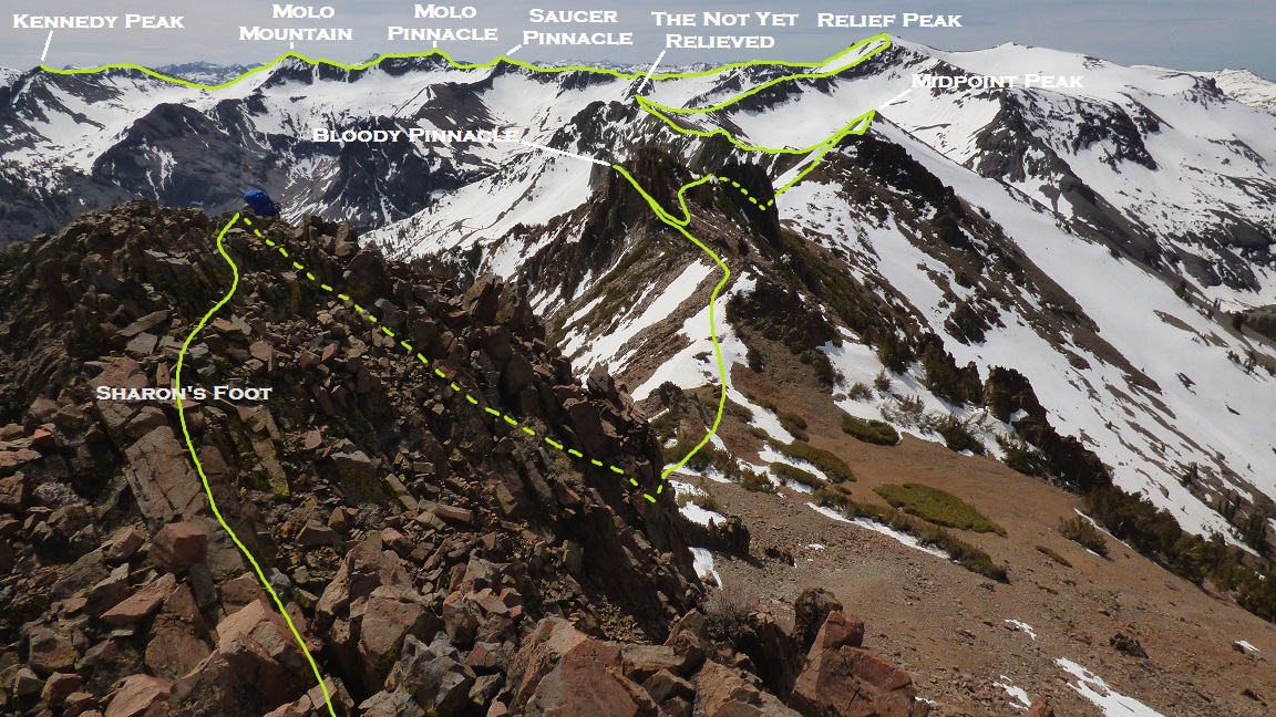
The two of us shouldered our heavy packs and began heading out shortly before sunrise. It was a little later than what we would've liked, but we had gotten to the trailhead late the previous night and needed the sleep for such a difficult day ahead. From the parking area (6,300 ft), we followed the paved Kennedy Meadows Rd about half a mile south to Kennedy Meadow Resort, then continued south on a dirt road, paralleling the Middle Fork of the Stanislaus River upstream. The dirt road eventually turned into trail, and ~2.3 mi after leaving the pavement, we found ourselves at the junction for a trail which headed northeast up the Kennedy Creek Drainage and another trail which headed south to Relief Reservoir. This junction marked the start of the traverse.
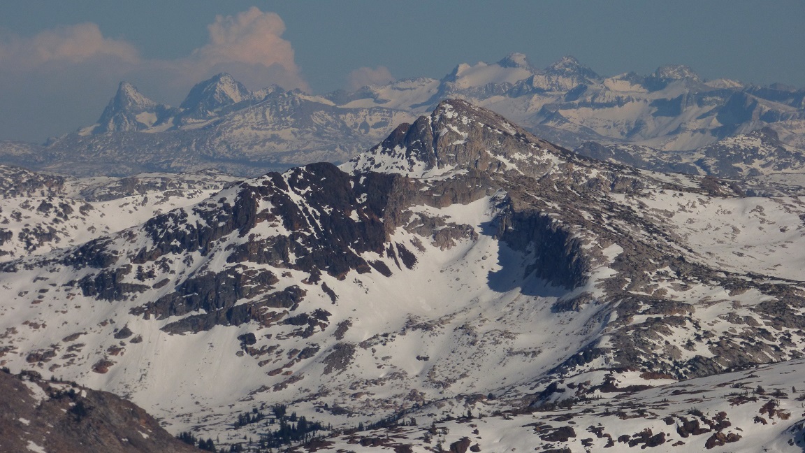
view of Sharon Peak (Mt. Sharon) from the approach

From the junction, we began bushwhacking southeast, following the ridge to Mt. Sharon which was roughly 3,500 ft above us. The ridge wasn't well defined at first, but became increasingly so as we ascended higher. The first 600 ft of ascent was comprised of bushwhacking and ledges (occasionally class 3 at times). The next 800 ft was a steep but clear ascent through trees, which soon began thinning out. We finally popped out above treeline (8,500 ft) and thought we could see the summit, but it turned out to be the first of several false summits. The remaining ridge to the summit was a mix of steep uphill walking, class 2-3 scrambling, and the occasional crossing of a thin snow-filled gully.
ascending Sharon Peak


At the summit of Mt. Sharon, we caught our first glimpse of just how massive the traverse really was. We could see most of it, with the eastern end of the traverse stretching far into the horizon. All the terrain from here on out would be free of any vegetation obstructions, reminding us every second of whatever remainder of the monstrous U we had left to traverse.
Kennedy Lake seen from Mt. Sharon

view southeast


south

After a food break at the summit, we walked for a few more minutes and came to Sharon's Foot: a small clump of rocks jutting up just south Sharon. Getting onto its summit was class 2. Getting down its south side involved a class 3+ downclimb of a 20 ft chimney.
view south-southeast from Sharon's Foot
Mason downclimbing the chimney

Next up was a sharp 40-50 ft pinnacle which we climbed via its NW Arete (class 4). As I made the first few moves on the arete, a rock came loose and knocked me in the head. Somewhat frantically, I quickly pushed the rock off the eastern side of the ridge before it could fall on my foot, watching it tumble several hundred feet down into Soda Canyon. I felt the spot where the rock had hit me and felt warm blood trickling out, thinking how I had made an absolutely stupid and foolhardy mistake leaving the helmet at home. It was this incident which led me to dub this pinnacle "Bloody Pinnacle." I quickly scrambled to the highpoint, tagged it, then came back down so Mason could take his turn on it.
Bloody Pinnacle seen from the north

view south from Bloody Pinnacle

Mason climbing the NW Arete


After finishing up with Bloody Pinnacle, we continued along the ridge by skirting along the west side of the next pinnacle (which was not as impressive) and climbed through a notch just south of the pinnacle to gain some easier class 1 ground, where we walked up the mellow class 1 north ridge of Midpoint Peak.


Midpoint Peak contained an interesting little register placed in 1978 by a party whose names we didn't recognize. Most of the writing was faded and unreadable, but we were able to see that they had claimed the first ascent of this peak. According to the register, we were the first ones to reach this peak since its placement.

The next section of ridge between Midpoint and The Not Yet Relieved (class 2) was an incredibly beautiful stretch of what I call a "blunt knife edge." It felt like a knife edge, but the ridge had a more rounded shape to it since it was composed of tiny bits of compacted shale and scree. As aesthetic as the ridge was, the bits of shale and scree were very sharp, and we had to exercise careful hand and foot placement as to not cut ourselves.


There were two highpoints in the vicinity of The Not Yet Relieved. The USGS 7.5' topo indicated that the northern one was higher. We climbed both and discovered that the southern one was likely higher. Both highpoints were class 2.
approaching both highpoints of The Not Yet Relieved

on the northern highpoint

the southern highpoint


Next up was Relief Peak, which had been visible for the past several hours but never seemed to get any closer until now. Relief's north ridge was a moderate class 2 slog up compacted scree. Somewhere around the halfway point up the north ridge, we encountered an impasse downclimb, and dropped ~30 ft into a very loose gully to the east in order to skirt around it.
views on the way up Relief Peak


summit area

view east from summit

To the east, we could see the long but easy ridge connecting Relief Peak to Molo Pinnacle. Along the ridge lay Saucer Pinnacle, which had looked like a pretty impressive pyramid back at Sharon Peak, but was merely another monochrome bump from Relief. We set off towards Saucer and Molo Pinnacle, with the thought of climbing that dreaded Molo Pinnacle on both our minds.
heading towards Saucer Pinnacle


between Saucer and Molo pinnacles was an intermittent pinnacle, which we climbed up and over on some very loose class 3-4 rock.


Now we had no choice but to face the mighty Molo Pinnacle. We took out the rope and established a belay on the west side. This was the side which Bob Burd had attempted climbing in 2011. I took note that there were no options for any protection, so the rope was pretty much useless for the ascent aspect. From the belay point, the first 20-or-so feet wasnt too bad, but the climbing quickly grew tougher as I moved up the pinnacle. I was eventually stymied at a 5.9 roof which had to be climbed, and without any pro, it was a move that I deemed too dangerous for myself to make. I slowly and carefully downclimbed back to the belay point, feeling rejected.
west side attempt

Now our only option was walking around to the eastern side of the pinnacle and seeing if there was an easier route. Bob had implied that the eastern side had looked harder, so it appeared as if the odds were against us. But as we rounded the corner and came upon the far eastern side, we caught a glimpse of something that resembled an arete of some sorts, and hurried over to it. As we examined it, I decided to give it a go.
We once again took out the rope and got out all the climbing gear, and Mason put me on belay (well, not really, with the lack of pro). The first 30 ft felt like 4th-low 5th and was very crumbly, followed by an extremely crumbly and sketchy class 5.6 chimney which turned out to be the crux. I spent several minutes in the chimney gasping and trying to make sure holds were absolutely solid. 9 out of 10 holds I tested would crumble at the first kick. Near the top of the pinnacle I passed less than a foot from a horn, and promptly put a sling on it and clipped in. Even though I knew that there was like a 95% chance it would not hold a fall, I slung it for psychological relief. After the chimney, the terrain got considerably easier (class 3-4), and I scrambled to a point just below the summit where I was able to locate a boulder and establish an anchor, which I then used to belay Mason up. While Mason was climbing up the chimney, he decided to bump the horn I had slung, and the entire thing almost immediately crumbled into a million little pieces which cascaded down the northern side of the mountain and out of sight. Go figure.
eastern side of Molo Pinnacle

about to belay Mason

After Mason had climbed to the anchor, we unroped and scrambled to the highpoint, where there was a short-lived celebratory atmosphere of our first ascent of Molo Pinnacle. The views were extremely amazing, and it was a surreal thought to think that we were the first to ever see it.
views from Molo Pinnacle


Now we had to get down off this crumbly mess of a pinnacle. We descended to the anchor and decided to look for better anchors which could be used for a rappel. After 10 minutes of searching, Mason located a large sturdy square block (which he seemed to have found by partially excavating it), which we decided to use. We set up the anchor, attached the rope, and I took the first rappel.
The rappel went pretty smoothly. As I rappelled, several little chunks of mountain were simply crumbling away at the slightest touch of the feet- a testament to how loose and delicate this pinnacle actually was.
Mason rappelling (as usual, the photo makes it look considerably less sheer)

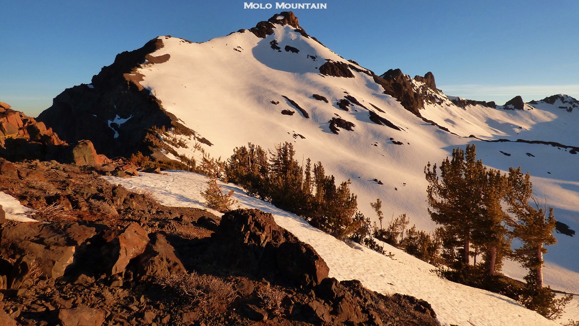
After packing up the rope and climbing gear, we re-shouldered our packs and continued east along the ridge towards Molo Mountain.
views on the way to Molo Mountain


Since Molo Mountain and Kennedy Peak were part of a spur extending northeast of the main traverse ridge, we cached our packs at the lowpoint between Molo Pinnacle and Molo Mountain (which I will refer to as "Molo Saddle").

From Molo Saddle, a band of highly loose class 4 rock lay to the east. Not wanting to deal with any more highly loose rock, we bypassed it by heading roughly 100 ft south and wrapping around it via a short and loose class 2 scree chute. After that, the remaining ascent to the summit was straightforward class 2.
view west from Molo Mountain


north

It looked like the only remaining peak we had time left for today would be Kennedy Peak, which looked incredibly picturesque from Molo. The first few hundred feet of the descent of Molo's northeast ridge was enjoyable class 2-3, followed by postholing for the remainder of the ridge. We were roughly halfway down the ridge when we realized that both of us had forgotten our headlamps at the packs back at Molo Saddle, and sunset was about 30 minutes away. Oh well. We continued traversing towards Kennedy.
looking back at Molo's northeast ridge from the Molo/Kennedy Saddle
The ascent of Kennedy's south ridge was easy class 1-2, but very aesthetic, especially with the setting sun bringing out vibrant colors


We reached the summit of Kennedy Peak right as the sun sank below the horizon, and only remained for a few minutes on the summit before heading right back down the south ridge and retracing our steps to Molo Saddle.
summit of Kennedy Peak


As the sky grew darker, we hurried as fast as possible back up Molo Mountain's northeast ridge, managing to get up and over all the class 3 sections before usable light ran out. As we climbed up and over the summit of Molo Mountain, only a thin sliver of light could be seen on the western horizon. As we descended back to Molo Saddle, we saw that the moon was lighting the eastern side of the mountain nicely, and we made it back down without a hitch,


Upon reaching Molo Saddle, we decided to just camp there despite the windy conditions. We struggled for some minutes setting the tents up in the heavy wind, but eventually managed to get hunkered down. None of us ate that much before we lay down and were soon fast asleep. All night long, we were constantly waking up as the constant wind rattled the tents.
go to Day 2
No comments:
Post a Comment