
back to day 1
home page
April 12, 2015
Both of us woke up roughly 30 minutes before sunrise. Seeing that it was already light out, I hastily rummaged through my stuff to grab the camera and boots. As I reached for the boots, I realized that I had stupidly left them beside the sleeping bag instead of putting them inside, and they were frozen solid. Based on the cursing coming from the other tent, I figured that Mason was dealing with the same issue. Since I had planned on catching the sunrise from Jobs Peak, there was no time to waste. I jammed both of my feet into the rock-hard boots, and proceeded north along the ridge towards Jobs Peak. The annoying thing was that only half of my foot would fit in the frozen boot, and I walked awkwardly, bouncing from side to side with both heels sticking outside the tops of the boots, and trying not to fall over. I remembered the ice axe sitting outside the tent back at camp which could serve as a cane, but there was no time to head back to retrieve it. The warm glow of the sun was already illuminating the eastern horizon. As I kept on moving, the boots gradually began defrosting, and pretty soon I was able to get my left foot fully into the boot.
As I made my way up Job’s south ridge, a
very handy use-trail appeared on the left (western) side of the ridge, which I
followed to the summit. As I reached the summit, the right boot had finally
thawed enough for me to get my entire foot in, and I leapt for joy. Right as my
feet touched the summit block, the tip of the sun made its way over the
horizon. Everything to the southeast was immediately lit up with the familiar
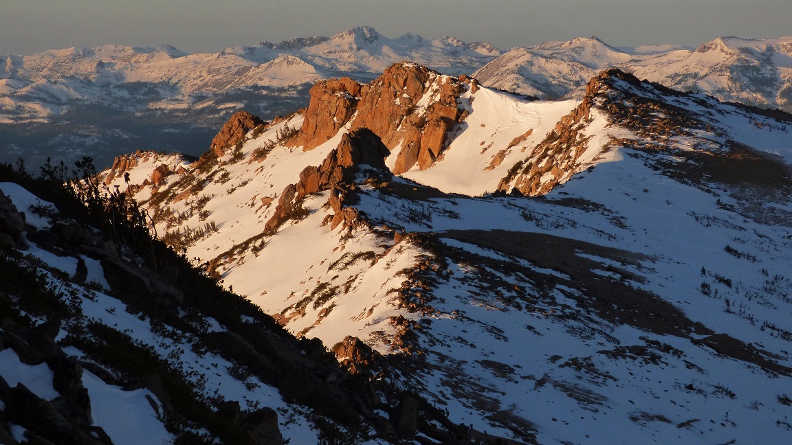
orange hues which never get old. To the west, the tops of Freel Peak and Jobs
Sister were lit up, with the long shadow of Jobs Peak slowly creeping down to
reveal more lit mountains.
sunrise on Jobs Peak


After Mason had arrived at the summit, we both headed back down to camp and proceeded to eat and pack up. Our next task was to descend the obvious ridge northwest to the low saddle (9,800 ft) between Jobs Peak and Jobs Sister, then ascend 1,000 ft to Jobs Sister.
Descending the ridge to the low saddle was
a very straightforward task, containing the usual postholing. As we reached the
saddle, we stopped to boil some snow and gaze up at the sandy-looking northeast
slope of Jobs Sister, which appeared long and tedious. But as we ascended the
slope, we were surprised how pleasant it was, and completed the ascent in
slightly over 30 minutes. From the summit, the large white rounded shape of
Freel Peak was visible to the west, looking rather out of place amidst all
the dirt and trees around it.
slogging up Jobs Sister

view west-northwest from Jobs Sister

east

southwest

west

A well defined use-trail exists between Jobs Sister and Freel Peak when the terrain is free of snow. We encountered the trail while descending the southwest side of Jobs Sister, which was free of snow, but were once again back in Posthole Land when we began ascending towards Freel.
Even for the least conditioned backcountry navigators, the slog from Jobs Sister to Freel is a very straightforward one.


Freel Peak's messy soggy register scraps

view east from Freel Peak

north

To the northwest lay the last two remaining peaks on the traverse: Trimmer Peak and Star Peak. These two peaks lay on a U-shaped ridge, with the top of the U facing northwest. The plan was to descend Freel's northwest ridge to the southeast side of the U, drop our packs, and do an out and back for Trimmer Peak. We would then grab our packs, head west to Star Peak, then head northwest down the obvious ridge which would spill us out at Fountain Place Rd.
Since the northwest ridge of Freel Peak was north-facing, we toiled for nearly an hour with deep snow, and were very glad to finally reach the point between Trimmer and Star where we dropped our packs.
descending Freel's northwest ridge


Trimmer Peak was a straightforward and pleasant hike from where we dropped our packs. The last few hundred feet before the summit contained some moderate bushwhacking. The summit block was a long spine which contained a multitude of short and fun class 3 routes.

view southeast from Trimmer Peak

north


south-southwest


west

Back at the packs, we ate and rested for a moment before heaving the packs back on and walking to Star Peak. The ridge to Star Peak was mostly flat with gradual undulations. Unlike the rest of the traverse so far, the snow on this section of ridge was surprisingly nice and we only sank a few inches with each step. The summit of Star Peak contained a slightly different view than that of Trimmer's.
view east-southeast from Star Peak

north


To the northwest was the long descent ridge that we would take back to Fountain Place Rd. From Star Peak, we headed directly northwest to an obvious large plateau, then curved west as the ridge narrowed and steepened. As the ridge began curving south towards a large bump (labeled as Point 8297 on the topo map), we left the ridge crest and dropped straight down to the west. The terrain was steep and tree covered, but not bad. It took a total of about an hour to descend from Star Peak to Fountain Place Rd.
last view of Tahoe before dropping down the ridge

view from the descent ridge

Point 8297 ahead

Back at Fountain Place Rd, it was nothing more than a 3.1-mile walk along the road back to the trailhead. As we got close to the trailhead, we were met with an increasing amount of locals who were out for afternoon bike rides, strolls, and dog walks, oblivious to the large traverse which loomed above them. Some of them stared briefly at the two of us walking awkwardly with our large bulky backpacks while they carried nothing more than water bottles and leashes. Maybe we looked like pot farmers who had just come down from a not-so-stealthy spring planting. It was quite an amusing and funny scene. We got back to the car at around 4:30 and gladly set down the packs.
back to Live Freel Or Die Traverse
No comments:
Post a Comment