
home page
April 11, 2015
Roughly 20 minutes before sunrise, the two of us woke up and groggily hoisted our packs onto our backs and began walking. We had spent the last few hours sleeping in the car which was parked on this side of Oneidas St at the edge of a neighborhood. We had parked 2.4 miles away from the start of the traverse, not being able to drive further up the road due to a locked gate.
After walking roughly 0.9 miles up the road, the road forked shortly after crossing a bridge over Saxon Creek, at which we took the right fork (Fountain Place Rd), which began steadily ascending to the east. We walked 1.5 miles on this road before turning right onto the very broad and nondescript north ridge of Trout Peak. Locating this turnoff point involved some careful studying of the map (Note how its located at a large turn shortly after the road gets close to Trout Creek). As we ascended the ridge, the terrain inevitably steepened and the deep powdery snow increased. By the time we were halfway up the ridge, we were postholing more than half a foot with each step.
postholing up Trout Peak's north ridge

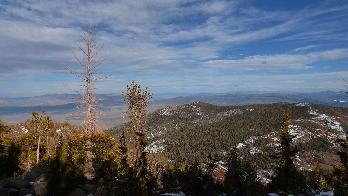
Eventually the terrain flattened out as we approached the broad summit plateau of Trout Peak. The highpoint was mostly under trees and was nothing too special. We stopped for a brief food break before heading southeast towards Fountain Place Peak.
summit view from Trout Peak

Fountain Place Peak's northwest ridge was short and steep and complete with more postholing. Like the last peak, this one was not too special either, with most of the views obstructed by a canopy of trees. We were however able to get a good view of our next peak to the southeast: Tucker Peak.
view north from Fountain Place Peak

southeast

The next section of ridge to Tucker Peak was very gentle and uneventful. Aside from the occasional knee-deep posthole, it was a straightforward walk. The highpoint of Tucker Peak was a jagged granite block which was partially hidden under some trees.
Tucker Peak summit block

view northeast from Tucker Peak

east

We ate lunch on Tucker Peak before continuing on to East Tucker Peak, which was equally as uneventful as the last peak. The one nice thing about East Tucker Peak was that its western side was clear of trees, giving us a spectacular view of the Crystal Range to the west.
Crystal Range seen from East Tucker Peak

Right after leaving the summit of East Tucker, we were met with some 2-3 ft postholing which took roughly 10 minutes to get through, followed by another short section of rock hopping. After that, it was a simple walk on gradual downhill slopes northeast to the low saddle between East Tucker and Saxon Peak, our next peak.
Saxon Peak was located on a minor spur which jutted to the northwest from the main traverse, so we stashed our packs at the saddle before climbing up to Saxon. From the saddle, we first headed a short distance up to the north to meet up with Saxon's southeast ridge, then followed the ridge to the summit. In my opinion, Saxon's southeast ridge was the most fun part of the traverse in terms of the climbing itself. The last ~0.1 mile of ridge before the summit thinned out and became rocky, making for some class 2-3 scrambling. The summit block was a ~25 ft class 3+ feature (some might call it low 4th) with excellent holds.
heading up Saxon's southeast ridge


climbing the class 3+ summit block


view south from Saxon Peak

After descending Saxon and getting back to the low saddle, we grabbed our packs and headed a few hundred feet to the east where we met up with the start of a minor nondescript ridge which we would descend to the northeast (see map) into Willow Creek Canyon.
looking down the nondescript ridge

The ridge descent started out steep, but did not exceed class 2 difficulty. As we got closer to Willow Creek Canyon, the slope mellowed out dramatically and we could barely tell that we were even on a ridge anymore. Upon reaching Willow Creek Canyon, we came across a dirt road which we remained on for a few hundred feet- just long enough to cross Willow Creek via a bridge, then began slogging up a slope to the east towards Armstrong Peak.
crossing Willow Creek

The initial slope slogging was mainly uneventful, but once we reached the southwest ridge proper of Armstrong Peak, the forest began opening up and we began catching glimpses of the highly scenic country to the south. The terrain itself was straightforward broad open forested ridge with minimal bushwhacking.
views while ascending Armstrong's southwest ridge


view east from Armstrong Peak
With both of us feeling somewhat beat, we stopped briefly at the summit of Armstrong in order to stuff ourselves with as much food as we could eat without feeling sick. Jobs Peak (our goal for tonight) still looked some distance away to the north.
We were not gonna get anywhere nearer to Jobs Peak by sitting on our butts, so we eventually got up and proceeded along the ridge. The descent of Armstrong's north ridge was a straightforward class 1-2 snow/sand slog, weaving between two large bumps just north of the summit.
view north while descending Armstrong's north ridge

Now it was time for the long slog up Job's south ridge. The first hundred feet of ridge started out nice and sandy, eventually reaching a large sandy plateau which looked good for camping, but we pressed onward. Shortly after the sandy plateau, the ridge narrowed and became a series of ups and downs complete with tedious class 2 boulder hopping. The boulders ended 30 minutes later and we were back to slogging up sandy slopes. For a short time, colorful rays of sunlight danced on the rocks, making them glow impressively orange. As the sun finally dropped behind Freel Peak, the temperature began to plummet. Roughly 20 minutes after sunset, we reached one of several small sandy saddles just south of Jobs Peak, and decided to spend the night there. Within 30 minutes of reaching the saddle, our tents were set up, we had eaten, and we were fast asleep.
looking back at Armstrong Peak from Job's south ridge

closeup of Round Top

the sandy plateau

Let the tedious rock hopping commence!


view of Armstrong Peak shortly before reaching camp

go to Day 2
No comments:
Post a Comment