
home page
July 15, 2014
I opened my eyes to faint rays of early morning light bathing the surrounding granite slopes. The bright orange glow of the sun could be seen towards the east steadily making its way over the distant Palisades. The forecast had called for a 50% chance of thunderstorms for this day, so an early start was crucial to getting as far as possible on the ridge before getting engulfed in rain and lightning. The thick low-hanging morning cumulus clouds were already a good indication that the atmosphere was saturated with moisture. After a breakfast of crackers and a small can of Vienna Sausage, I quickly broke camp and was on my way ESE towards Horsehead Peak.
Immediately ESE of Holster Saddle rose a ramp strewn with granite boulders. This was the beginning of Horsehead Peak's northwest ridge (Secor refers to it as the west ridge).
morning at Holster Saddle


anticrepuscular rays

The class 3 northwest ridge of Horsehead peak was quite fun. The rock quality was nice and solid, and there were even a few short sections involving knife edge moves.


My goal for today was to get past Finger Peak, which looked incredibly far away. Finger Peak looked incredibly dominant and picturesque, and had had an allure on me ever since I first laid eyes on it.

summit of Horsehead Peak (12,200 ft), looking southeast


I descended Horsehead Peak by heading down one of several chutes on its south face, which turned out to be class 3-4. Upon looking back at the face after I had gotten off the mountain, I noticed easier chutes to the east of my route.
looking down my descent chute

After getting down from Horsehead, it was a short walk to Gunsight Pass (11,640 ft), which was conveniently marked by a tarn. To the southwest of Gunsight Pass lay Confusion Peak and its class 3 northeast ridge.


Confusion's northeast ridge was your pretty typical Sierra class 3 scramble, comprised of solid granite boulders and a few slabs. It included a false summit which needed to be climbed up and over.

Horsehead Peak's south face and southeast ridge seen from Confusion Peak's northeast ridge

true summit seen from false summit

looking back at the false summit

summit of Confusion Peak (12,180 ft), looking south

northeast

From Confusion Peak, it seemed tempting to simply drop down to the west side of Lake Confusion and head straight over to the next peak: Valor Peak. But in order to stay true to the LeConte Divide and thus the traverse, I needed to head back a little ways and loop around the north and east sides of the lake, passing through Confusion Pass (11,380 ft).
above Confusion Lake

views from Confusion Pass


Since Lake Confusion was the last direct and reliable access to water until Tunemah Lake (which I didn't expect to reach until the next day), I filled up every single one of my water storage containers, adding several pounds to my pack.
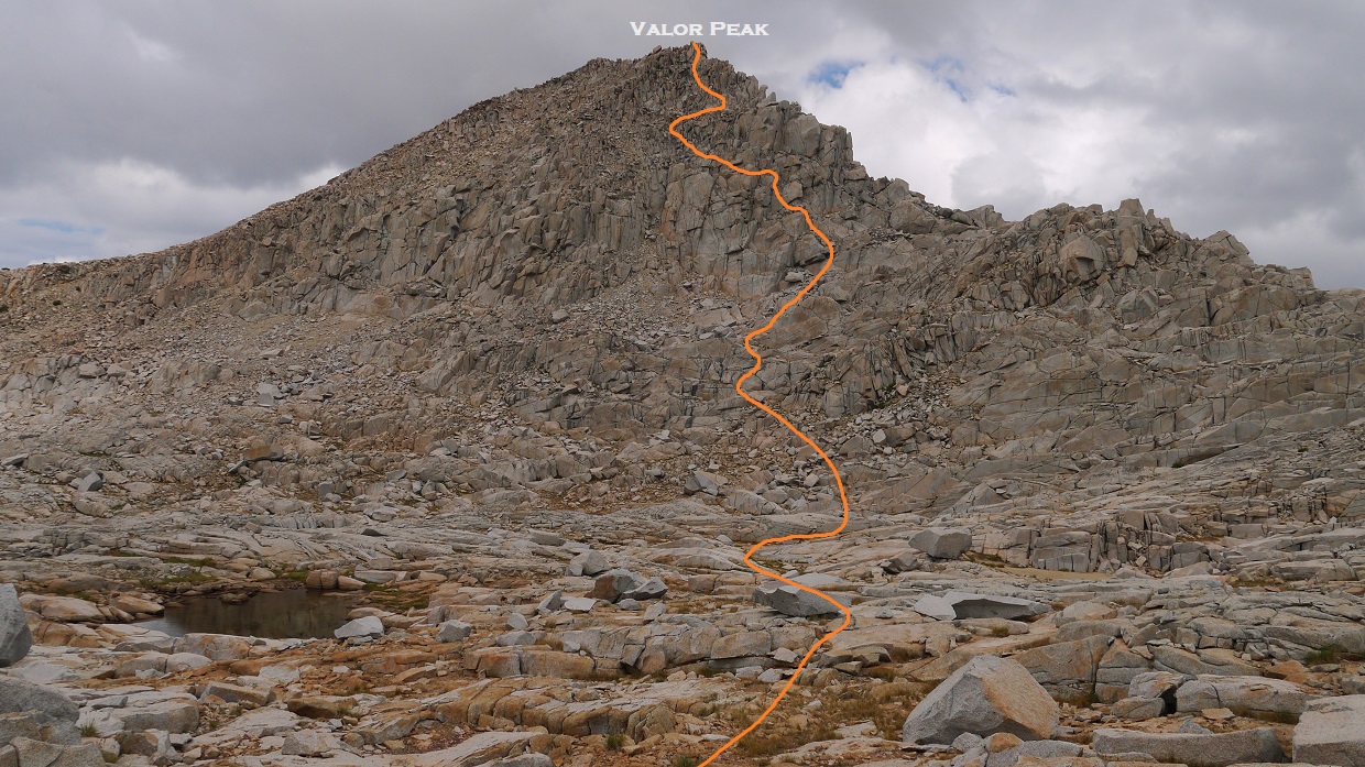
Between Lake Confusion and the base of Valor Peak, the ridge was shallow and made up of mainly large and low angled granite slabs. Here and there were various shallow pools of stagnant water which were skimming with water bugs of various shapes and sizes. This easy part of the ridge made for some relaxing walking in the wake of much more difficult terrain that was soon to come.
Valor Peak


Horsehead Peak in the distance

In order to attain Valor Peak's northwest ridge, I ascended one of several class 3 gullies to the right (southwest) side of the ridge. Once on the ridge itself, a short and solid class 3 scramble ensued to the summit.

summit of Valor Peak (12,212 ft), looking northwest

southwest

south

Finger Peak getting closer

southeast

Getting down from Valor Peak turned out to be a little tricky. I stayed on the ridge itself for a few hundred feet, then dropped slightly down to the right onto the southeast face. At first it seemed like descending the face would be straightforward, but as I got a little lower, several class 3-5 vertical slabs lay in the way. I slowly and carefully weaved through the maze of slabs, keeping the difficulty to class 4 at most.
my approximate line of descent
The next peak (Mt. Reinstein) now loomed high above me to the south, looking like a giant pile of granite boulders. At 12,586 ft of elevation, Reinstein was the highest peak on the Blackcap Traverse. It also marked the junction of the LeConte and White divides.
The large basin which lay in between Valor Peak and Mt. Reinstein was littered with an array of low angle granite slabs which made for relatively easy travel. I passed by several good sized tarns, making me feel a little silly for packing so much water back at Lake Confusion.
Reinstein from the basin

Reinstein's north ridge was pretty much what I had envisioned it to be: a mainly class 2 granite boulder hop. There was a short class 3 section a short distance above Valor Pass (11,800 ft) which needed to be climbed in order to get onto the ridge itself.
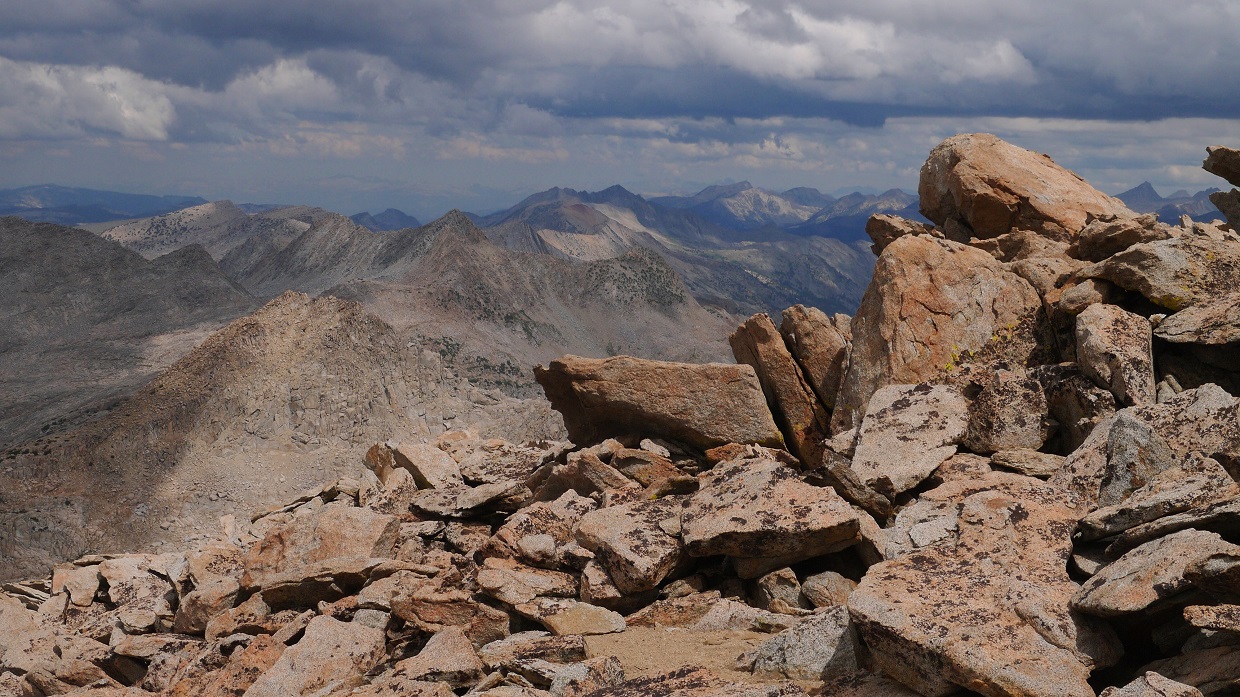
view SSE from Reinstein's summit (12,586 ft)

southwest

northwest

register

Descending Reinstein's south ridge was pretty much like ascending its north ridge, complete with more class 2 boulder hopping. Up ahead, Bibay Peak looked pretty impressive.
Bibay Peak

looking back at Reinstein's south ridge

Bibay's class 3 northwest ridge turned out to be a highly enjoyable scramble, to the point where it became one of my favorite Sierra class 3 routes. It would probably be more of a classic Sierra scramble (such as Russell's east ridge) if it wasnt so far out in the middle of nowhere. The ridge was comprised of amazingly clean and sticky granite and several sections of exposed knife edges.


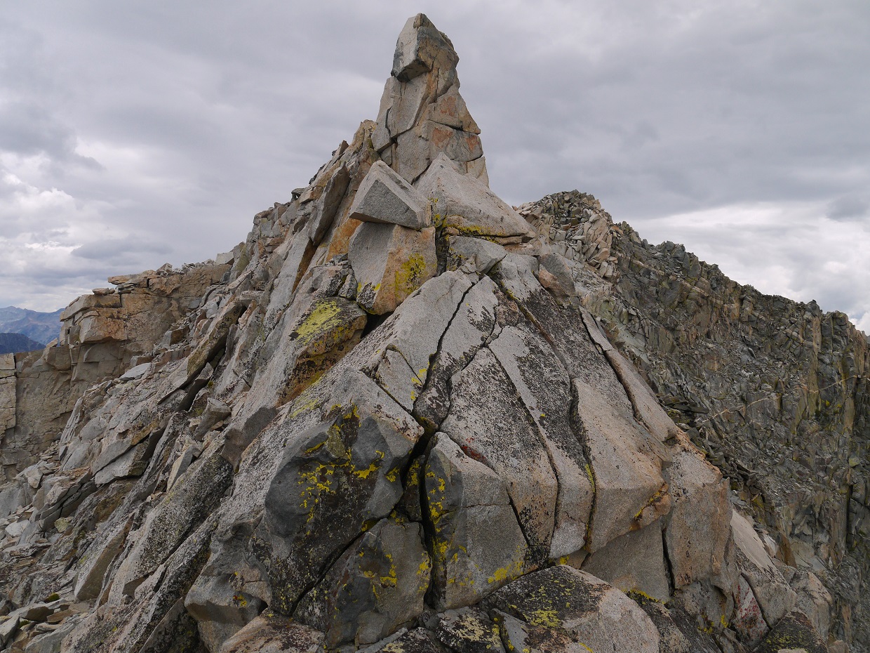
summit of Bibay Peak (12,500 ft), looking southeast

northwest

north

next up: Ram Peak

Getting from Bibay Peak over to Ram Peak turned out to be somewhat tricky. I descended Bibay's south ridge for a few hundred feet to where it began hooking slightly over towards the left (east), and found myself standing over a 20+ ft drop which would have to be rappelled. Since all my technical climbing gear was sitting in the car back at North Lake Trailhead, I had no choice but to find a bypass. To the south was a large wide and slabby class 3 gully which I descended for about 100 ft of elevation, then crossed over to the left (east) and climbed back onto the ridge.
ridge gets steeper

the dropoff

class 3 gully to bypass the dropoff

After I got back onto the ridge, it was class 3 for the remaining distance to the saddle (11,780 ft) before Ram Peak. There were a few pesky pinnacles along the way, but it was easy to work around them.


Ram Peak's northwest ridge started off class 2-3, but grew steeper as it went on. Near the top of the ridge, I found myself making a few class 4 moves. By this point, the rock was solid and pretty reliable.

view NNW from Ram Peak (12,221 ft)

northeast

southeast

southwest

Getting over to Oyster Peak involved mainly class 2 rock hopping and was not too eventful. The actual summit of Oyster Peak was a large pinnacle detached from the rest of the mountain. Surmounting this pinnacle involved a few fun and wildly exposed class 3 moves. Standing on the summit block, I felt as if I was standing on the edge of the High Sierra.
Oyster's northeast ridge

summit pinnacle

Pearl Lake

summit block

view west from Oyster Peak summit (12,323 ft)

east

register

To the south of Oyster Peak lay the jagged profile of Finger Peak and the long thin-looking ridge leading up to it. My plan was to take to the ridge to Finger Gap, then drop a short ways southwest into a small bowl bordered by Finger's north and northwest ridges. From there, there were several options to climb south onto the northwest ridge, then follow the ridge to Finger's summit.

For the first few hundred feet of descent down Oyster's south ridge, the terrain was strewn with large class 2 boulders. After that, the ridge narrowed and quickly turned to class 3. The ridge would continue to be class 3, complete with several vertical pinnacles which needed to be worked around until about halfway between Oyster and Finger, where the ridge flattened out and contained several long, parallel blocks which could be simply walked across. Sometimes the blocks were so well arranged that it looked like someone had carefully sculpted and put them there.


As I reached Finger Gap, I was welcomed by this giant rock giving me the finger.

view into Blackcap Basin

From the small bowl southwest of Finger Gap, there were three sub-class 5 ways to access the northwest ridge. The easiest way was a cruddy and nasty looking sand gully to the right which did not look at all appealing. To the left of that was an even cruddier and nastier looking gully which contained the slippery remnants of a melting glacier, making it blatantly dangerous. To the left of that gully was a "weak spot" in the rocks which looked considerably more solid than the other two options. I decided to take it.

Even though it did not look too bad compared to the other two options, my route still contained a fair amount of loose and sandy rock, and I had to tread lightly. It involved mostly class 3 climbing with one or two low class 4 moves. Thankfully, this didn't last long and I found myself on Finger's northwest ridge within five minutes.

From where I was standing, a pointed peak rose up to to the southeast, which I initially thought was Finger Peak. As I reached the top of it, it turned out to be a false summit. Since the ridge between the false and true summits looked class 5, I descended a hundred feet or so from the false summit and took an obvious class 3 rock gully up to the real one. As I clambered onto the summit block, a few low rumbles of thunder sounded from the north. A few minutes later, a thick layer of cumulus clouds engulfed the summit.
the false summit seen from the spot where I popped out on Finger's northwest ridge

looking west

true summit seen from false summit

Finger Peak's class 3 summit block

view northwest from Finger Peak (12,404 ft)

east

register

As I began the descent of Finger's east ridge towards Blue Canyon Pass (11,520 ft) and Blue Canyon Peak, a few more rumbles of thunder (now louder) sounded again from the north. All day long I had been surrounded by thunderstorms, but all of them had managed to miss me by a several miles. It looked like my good luck with the weather was beginning to run out.
The descent of Finger's east ridge was fairly straightforward, containing moderate class 3 scrambling on rock which was slightly loose in places.
one of several pillars on the east ridge

As I descended below the cloud bank, I could make out heavy rain falling to the north, completely engulfing Mt. Goddard which was approximately 5 miles away. I would need to get to Blue Canyon Pass ASAP and shelter somewhere below it.
Uh oh. Time to skedaddle!

Roughly 25 minutes after leaving the summit of Finger Peak, I arrived at Blue Canyon Pass. To the south of the pass were several flat spots which looked good for camping, and I began descending almost immediately. Just before I started down, I took one last glimpse north and saw that the rain had now engulfed Bibay Peak, now less than 3 miles away.
Finding a flat ledge about 100 ft below Blue Canyon Pass, I hurriedly set up the tent, finishing up in roughly 5 minutes. As soon as I jumped in, the downpour started. Whew! That was close.
Since it was already 6pm, I decided to just spend the night here. The storm could last several hours, and even if it didn't, I wasnt too big on the idea of packing up a wet tent and continuing on wet and slippery rock. For the next hour and a half, I ate dinner and poured over maps of the remainder of the traverse.
chilling in the Blackcap Hilton

The storm would continue on throughout the first half of the night, dropping several more lightning bolts and downpours of hail. By 7:30, I went to sleep. I would need to get as much sleep as possible tonight. By the looks of the maps, I would not be able to afford this luxury tomorrow. Tomorrow was going to be a tough day.
go to Day 4
No comments:
Post a Comment