
August 21, 2013
Day 6 of the 2013 Sierra Challenge was one of the last hard days of the Challenge. It involved a climb up Mt. Ickes, a remote peak west of Pinchot Pass. The fastest route to Pinchot Pass involved hiking over Taboose pass and latching onto the JMT, then heading south. Luckily, the overwhelming majority of today's mileage and gain would be done on trails. Eight of us met at Taboose Pass Trailhead (5,430 ft) for a 4am start.
| Peak | Elevation | Topographic Prominence | Summit Coordinates (lat/lon) |
|---|---|---|---|
| Mt. Ickes | 12,968 ft | 853 ft | 36.933041, -118.439301 |
| Mt. O'Burley | 12,631 ft | 328 ft | 36.933041, -118.427027 |
Getting to the trailhead (2WD accessible)
Trailhead coordinates (lat/lon): 37.009580, -118.327371
Day 6 sleepy hikers (photo by Bob Burd)

The Taboose Pass Trail gained 6,200 ft in 7.2 miles between the trailhead and Taboose Pass (11,430 ft). The first mile or so of the trail is soft and sandy, followed by generally rocky trail for the remaining distance to the pass. Since the trail is maintained, it is easy to follow. There is a source of water somewhere within every two miles of the trail, so there's no need to carry large stores of water.
For the first few miles, a tight knit group of Bob, Sean, Pat, Chris, Michael, and I headed up the trail, our minds zoning in and out of focus. A dark band of thick clouds began obscuring the near-full moon, and I wondered if it was going to rain soon.
As the sky began to grow lighter, people began breaking off from the group and hiking at their own paces. I was now hiking solo, with Bob and Pat not far behind. About 30 minutes before sunrise, a few drops of rain began to fall. A brief but brilliantly red sunrise lit up the eastern horizon. Within a few minutes, the band of clouds had moved in front of the sun again as the rain and wind picked up.
As the sky began to grow lighter, people began breaking off from the group and hiking at their own paces. I was now hiking solo, with Bob and Pat not far behind. About 30 minutes before sunrise, a few drops of rain began to fall. A brief but brilliantly red sunrise lit up the eastern horizon. Within a few minutes, the band of clouds had moved in front of the sun again as the rain and wind picked up.


Shortly before Taboose Pass, the sun broke through a hole in the clouds to glaze the surrounding granite cliffs in vivid dramatic colors. A large rainbow appeared to the west, providing a magnificent contrast to the dark clouds overhead.


From Taboose Pass, the trail gradually descended for 2.5 miles to a junction with the JMT (10,790 ft).


Once on the JMT, I turned south (left) and headed 1.5 miles to the south side of Lake Marjorie (11,135 ft). The JMT wound its way up a side canyon towards Pinchot Pass, passing through some very scenic alpine terrain.


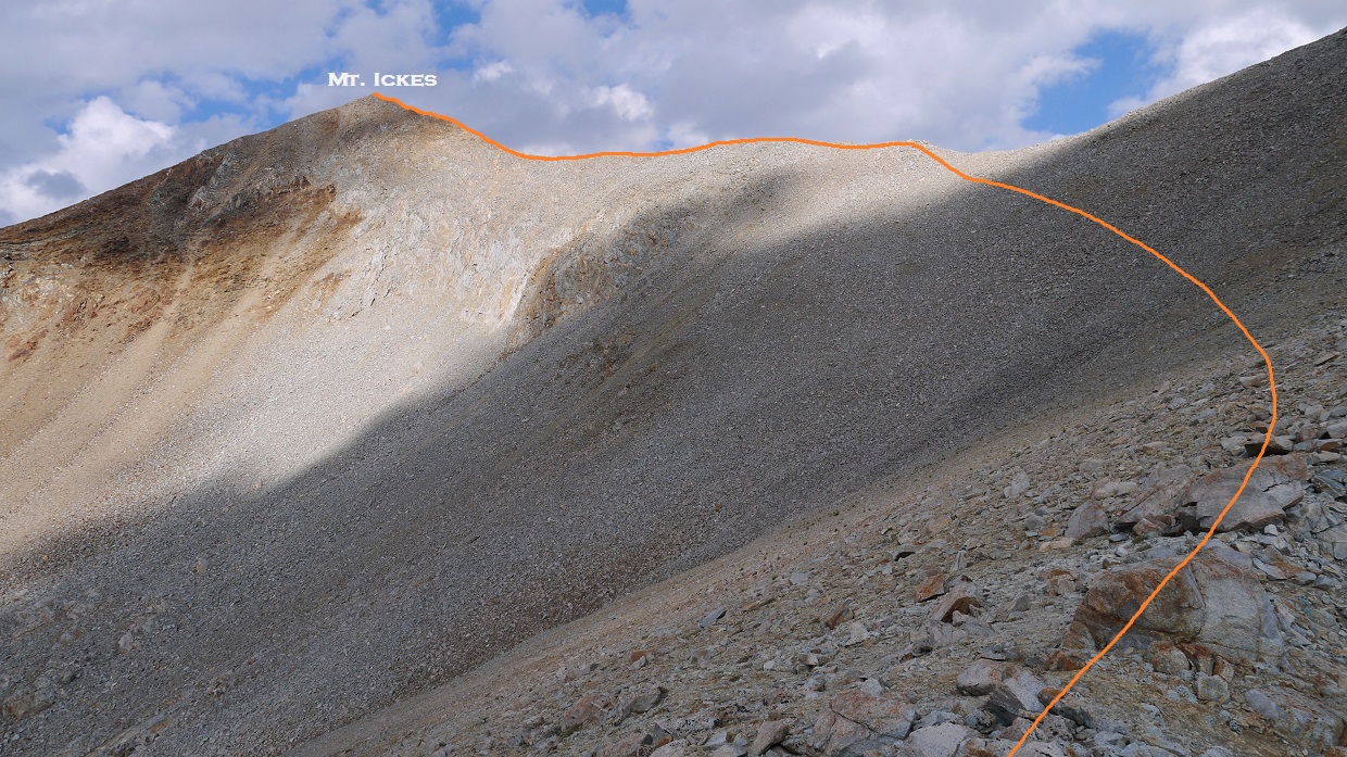
Upon reaching Lake Marjorie, I contoured around the lake's south side and headed up a chute south of the lake. Getting up this chute involved some rock hopping on loose moraine talus and scree. The last hundred feet or so before a prominent saddle (which I will refer to as "Ickes-O'Burley Saddle") contained some loose class 3 climbing, where most of the holds gave away the moment I grabbed them.


looking back down the chute from Ickes-O'Burley Saddle (12,310 ft)

From Ickes-O'Burley Saddle, I turned west (right) on the ridge and followed it a short distance to the summit of Mt. Ickes.

Even though the climb up to Ickes was pretty icky, there were nice panoramic views from its summit. There was even a register present, placed by the Sierra Club in 1966.
view west from summit

west-northwest

northwest


northeast

south

southwest

first page of register

After signing the register and stuffing down a chocolate bar, I descended back towards Ickes-O'Burley Saddle. Not long before the saddle, I spotted three figures descending from a peak to the east. Who could that be?
As I got to the pass, I met up with Sean, Bob, and Pat, who had taken a look at the chute from Lake Marjorie and decided that it was too loose and cruddy for them. They had headed slightly more south on the JMT and ascended the northeast ridge of the peak I had seen them on earlier. Once on the summit, they had placed a register and dubbed it " Mt. O'Burley" by combining their last names (Sean O'rourke, Bob Burd, Pat Hadley), naming this peak the same way that renowned peakbagger Andy Smatko had done so for several of his first ascents.
I stood there for a minute staring at Mt. O'Burley as the other three headed towards Mt. Ickes. Even though O'Burley would not count as a bonus peak for the Challenge, my peakbagger senses were tingling and I had to climb it. I set off up the ridge to O'Burley, which turned out to be a very straightforward walk-up.

view north from summit


northeast

southwest

west

brand new register

After signing the register, I descended back down the chute below Ickes-O'Burley Saddle and back to the JMT.


Upon reaching the JMT, I began lightly jogging towards Taboose Pass, trying hard to keep a constant pace. A light breeze blew through the valley, making the air feel refreshing. Dark clouds were beginning to gather overhead, signaling the beginning of a long line of thunderstorms which would move from south to north along the Sierra Crest.


As I reached Taboose Pass, the first booms of thunder began to sound, followed by a brief shower. These showers would intensify throughout the day as the thunderheads mushroomed upwards.
Taboose Pass

Originally, I felt that the Taboose Pass Trail would make a good running trail with a nice smooth descent, but this turned out not to be the case. The rocky nature of the trail was hard on my knees, and I would have to constantly apply the brakes while running on several long downhill stretches.


The last mile of sandy trail came as a nice relief, feeling soft and soothing on the feet and knees. I got back to the trailhead at 1:37 pm, looking up at the dark clouds that were now hovering over Taboose Pass, with numerous lightning bolts bouncing all over the mountains.


Final Stats
25.6 miles
9,700 ft gain/loss

Weather Forecasts
Trailhead
8,200 ft on Taboose Pass Trail
Taboose Pass
Mt. Ickes, Mt. O'Burley (Mt. Ickes has an elevation of 12,968 ft. Keep in mind that this forecast is for 11,654 ft)
Peakbagger Pages
Mt. Ickes
Mt. O'Burley
Other
Bob Burd trip report
Sean O'Rourke trip report
High Sierra Topix message board
Inyo National Forest
No comments:
Post a Comment