September 1, 2016
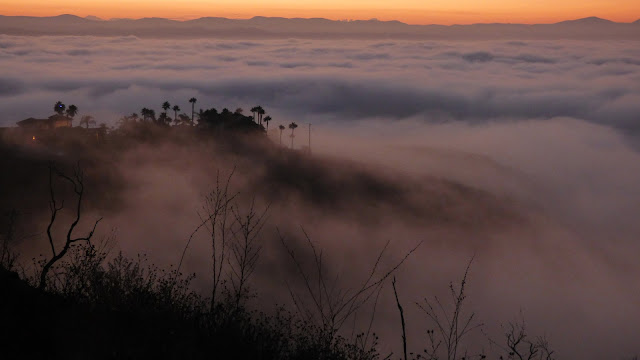
Just south of San Marcos in north San Diego County are a small cluster of urban hills under 2,000 ft of elevation, the highest of which is a P1K called Mt. Whitney. I had first noticed it while casually scanning local topos, also noting several other hills nearby. I decided to save these hills for a foggy morning in September, hoping to catch a sunrise above the fog.
| Peak | Elevation | Topographic Prominence | Summit Coordinates (lat/lon) |
|---|---|---|---|
| Mt. Whitney | 1,736 ft | 1,046 ft | 33.1089, -117.1553 |
| Franks Peak | 1,688 ft | 238 ft | 33.1050, -117.1572 |
| Double Peak | 1,644 ft | 474 ft | 33.1094, -117.1777 |
| San Marcos Peak | 1,220 ft | 40 ft | 33.1114, -117.2022 |
| Cerro de las Posas | 1,350 ft | 180 ft | 33.1082, -117.1928 |
Getting to the trailhead (Double/San Marcos/Cerro de las Posas)
Trailhead coordinates (Whitney/Franks): 33.1101, -117.1542
Trailhead coordinates (Double/San Marcos/Cerro de las Posas): 33.1248, -117.1788
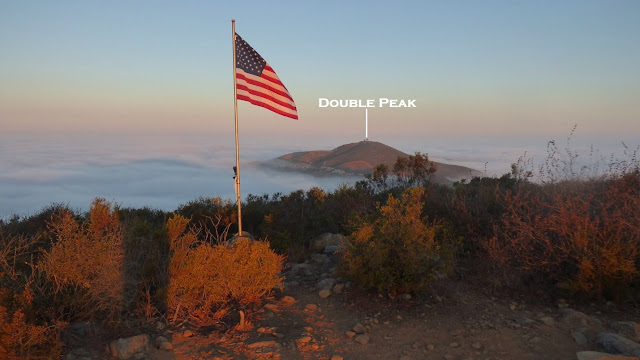
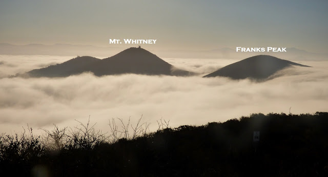
Mt. Whitney and Frank's Peak are located on the east side of their hilly cluster. They seemed to be popular with local joggers who frequently used the area for workouts. I arrived at my starting point at around 5:40am as the eastern horizon was beginning to brighten up, parking at the last public access point before a gate on Washingtonia Dr, right across from the start of a long driveway to a distant luxury home. Next to the gate was a sign indicating "authorized personnel only." No one else I previously talked to had had any problems here, so I authorized myself and continued up. From there, it was a few minutes walk along a paved road to the summit of Whitney, which was crowned with a large transmission tower. I enjoyed some nice dawn scenery from the summit of Whitney, then headed off southwest for a short walk along connecting trails to the summit of Franks Peak where I watched the sunrise. I noticed Double Peak to the west just barely poking out of the fog. That was to be my next destination.
summit of Whitney
summit of Franks Peak
back at the start
I got back to the car at 6:50am and drove over to Lakeview Park in San Marcos. Based on what some friends had told me, it was a popular local workout to hike up Double Peak from this park.
Lakeview Park
I started off by walking up a main road heading south out of the park, passing by the west side of the tiny Discovery Lake. This road (or fancy trail) continued south up a hillside, through a residential area, and up another hillside.
Discovery Lake
fancy trail
As the fancy trail reached a large junction above the residential area, I turned right, walked about a hundred feet, and located a use-trail heading south. This would lead to the summit of Double Peak, where I popped out of the fog right below its summit. Double Peak's summit was crowned with several picnic tables and a telescope. The most interesting thing (at least in my opinion) was a diagram indicating nearby landmarks, including Mt. Whitney, Franks Peak, and San Marcos Peak.
From Double Peak, I took the Ridgeline Trail west along the broad ridge connecting Double Peak to San Marcos Peak. The total distance between these two peaks was about 1.5 miles and consisted of the same type of well graded fancy trail that was found north of Double Peak.
San Marcos Peak's highpoint was crowned with a series of radio towers.
I hit the highpoint of Cerro de las Posas on the way back from San Marcos Peak, taking a side trail that branched off the Ridgeline Trail just west of Pearl Dr. I walked a few hundred feet on this side trail, turning west (right) upon noticing a fence ahead, walking about 100 ft to the highpoint which was pretty uninspiring.
I headed back along the Ridgeline Trail, eventually intersecting the trail I had used to ascend Double Peak, taking it down to Lakeview Park. Everywhere along the trail were locals out for their morning workouts- quite a nice way to spend a Thursday morning.
Stats for Whitney/Franks
2.4 miles
800 ft gain/loss
Stats for Double/San Marcos/Cerro de las Posas
6.9 miles
1,840 ft gain/loss
Weather Forecasts
all peaks
Peakbagger Pages
Mt. Whitney
Franks Peak
Double Peak
San Marcos Peak
Cerro de las Posas
Summitpost Pages
Double Peak


i don't know if this is a repeat comment, it seems my internet might not be working, but really waht i would like to know is how to scale/hike mt. whitney because the way you described, getting up to some gate with nothing more than a "not authorized" sign is not there anymore. when we went up there this last Sunday, there was a three-way culdesac and all of them remarked about private property and the one that we thought might lead up to the summit had a sign that said something like 'restricted access' and 'police will be notified,' and if that wasn't bad enough, there was a camera set up. so i guess what i'm wondering is if this was the same set up you encountered and if there is some other way to access mount whitney. btw we also tried from twin oaks valley and that did not work; there was a winery and a fence and some sorely looking gargoyles...
ReplyDeleteThat was not the case when I was there- just the gate with the not authorized sign. I imagine there would be another way to approach it from the south. There were lots of bike tire tracks around the saddle between Whitney and Franks.
Deletecheck it out again. i think they changed some things. i was really excited about your trails but it looks like they have been wiped out. we took the trail from san marcos peak to double peak, it's still good. but mount whitney now seems completely inaccessible for hikers. i would welcome a suggestion of a new trail.
DeleteThat's the way, tho. People do go around that gate (and camera set up) all the time, including the guided hikes organized by the city (there's one coming up in November: http://www.san-marcos.net/Home/Components/Calendar/Event/5479/20 ). I don't think the camera is monitored (it just takes footage in case something happens up there).
DeleteThe winery route (Bella Vita Way) is private indeed (tho there's really that one gate. Just a chip shot beyond it is the intersection with Atterbury). If you're hiking, tho, you can try coming up Atterbury from Questhaven (it turns into moderately gnarly dirt with lots of pebbles for a stretch after the school, but becomes paved again before it links up with the top of Bella Vita Way and on to Washingtonia.
Lilah I own the 10 acres on the north side of the Whitney peak. The gate is on my property. If u hike up the asphalt you are always welcome. It's a beautiful view from the top. Eventually I will gate the road at the bottom but only to stop vehicles - I welcome hikers and bikers because they don't litter and party up there.
ReplyDeleteSam
It sure is beautiful and mellow up there. Thank you, Sam!
DeleteNow that the gate is there at Washingtonia/Ocean View, is it still allowable for bikers/hikers to go up to the Whitney summit via Washingtonia? "No trespassing" sign was on the gate so I turned around here.
DeleteThis comment has been removed by the author.
ReplyDeleteThere is also a gate on Washingtonia at the fork with Indian Ridge Rd and Ocean View Dr. with "No Trespassing" sign and also that there is video surveillance. I'm not sure if this is all private and inaccessible now. I rode up Coronado Hills Drive then onto Washingtonia and stopped at that gate. Obviously people have been up to the summit of Whitney before but I don't know if anyone still can? Obviously I didn't feel comfortable going past this gate on my bike or if I was hiking on the paved road. Anyone have any additional information on this? Thanks
ReplyDeleteWe were working up there yesterday at the tower. The gates are as described recently and we of course had no issues driving up to work on the site. My gut feeling is that the gates are just to stop vehicles from going up the private road to party and litter rather than hikers, cyclists and joggers. It is a very peaceful area, very clean, and has amazing views. When we were up there a walker did come up to the summit - not sure if she was a local resident or not. We just said Hi and she was soon back on her way down the hill. At any rate, if you do venture up there please always follow the rules of being in the great wide open: pack out your trash and be respectful of the residents. I would also advise to exercise caution when walking on the road. It is very narrow and yes, workers do visit the tower on occasion so keep an eye out for us and we will do the same!
ReplyDeleteHikers and bikers still go up to Whitney tower. I think the gates are mainly for vehicles. Wouldn't be good for people to drive up and just sit in their cars (hikers and cyclists tend to go to the top, look around a bit, and then leave without leaving 6 pack and other food litter behind).
ReplyDeleteAll those little roads are tarmac and quite steep, so I imagine not having non-local/working cars up there helps preserve road surface a bit, too. All the locals have been very friendly to me.
If you park at the Ridgeline Trail Head dirt lot, you can cross the street at the light and hike up via Attebury Rd. A bunch of hikers were up at the Whitney Tower last weekend, enjoying their first outing since the pandemic started. :)