
home page
October 18, 2014
The two of us arrived at Norris Trailhead Saturday at around 2 in the morning, and got a few hours of sleep before realizing that we had overslept and the sun was shining brightly on the parking lot. After quickly packing up our things, we headed out at 8:15am.
Norris Trailhead (7,500 ft)

The trail was well defined and easy to follow. We took it for 2.5 miles, passing by Norris Lake along the way, to a spot just before the first of the Jackass Lakes (Lake 8808 on topo map). From there, we left the trail and headed in a general western direction up a short section of slabs and then gentle forested slopes towards Lake 9150.
Norris Lake

heading towards Lake 9150

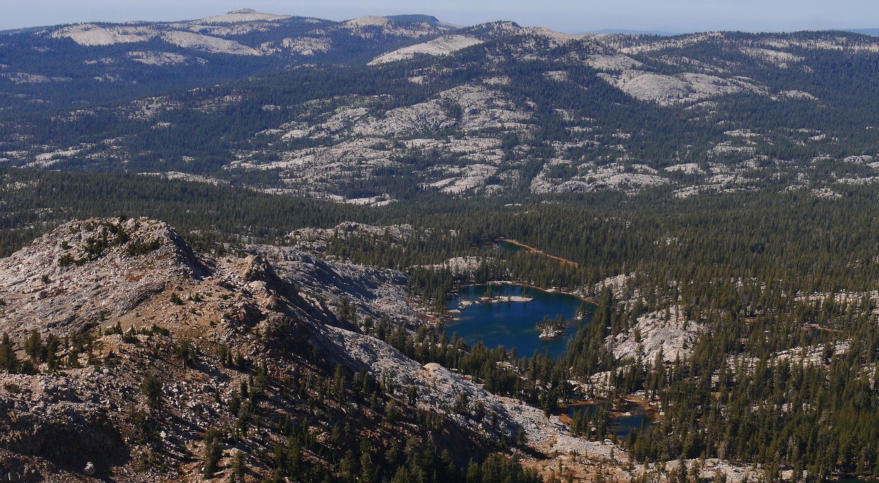
views of the Ritter Range


Shortly before Lake 9150, the dark triangular summit of Madera Peak became visible to the northwest.

The southwest ridge of Madera Peak lay directly west of Lake 9150, forming a bowl which encompassed three sides of the lake. There were several different class 2 routes which could be used to access the southwest ridge. We boulder hopped our way up the head of the bowl on the western side of the lake.
our route up onto the southwest ridge

Once on the ridge, it was an easy mostly class 1 walk up to Madera Peak. The views really opened up here, revealing the Jackass Lakes to the east and the Clark and Ritter ranges to the north.


We reached the summit of Madera at around 11:20am, and gazed north across the ridge which would form the remainder of the traverse. Triple Divide Peak (the northern end of the traverse) looked far and dominating, with the other eleven peaks scattered in between. There was an improvised register at the summit which consisted of a water bottle stuffed with a few scraps of notebook paper.

view north-northeast from Madera Peak

east

north-northwest

The ridge walk from Madera Peak to Sing Peak was fairly uneventful. Madera's northwest ridge was a straightforward walk on clinky metamorphic talus and sand. Sing's southeast ridge was class 2.
view southwest from Sing Peak

north

Sing's north ridge was a little more exciting, containing the first short section of class 3 terrain we had encountered so far on the traverse. The rock in general was not too loose, but was slightly crumbly in a few places.
heading down Sing's north ridge

looking back at Sing's north ridge

At the tip of Gale's south ridge was a smaller peak which I had dubbed "South Gale." There isn't really much to this peak, but it was still a noteworthy highpoint on the ridge. It even contained its own register. The terrain between South Gale and Gale Peak was class 2 and contained great views of Chain Lakes to the west.
views while approaching South Gale


Chain Lakes seen from the summit of South Gale

looking back south at our progress

South Gale register

north towards Gale

Chain Lakes seen from somewhere between South Gale and Gale

Lillian Lake

At the summit of Gale, we took some time to rest, eat, and take in the views. In my opinion, Gale contained the best summit views on the traverse.
Gale summit views


benchmark and register

remainder of the traverse

After a short class 2 descent of Gale's northeast ridge, we scrambled up the southwest ridge of Chittenden Peak which contained a few fun class 3 moves.


Breeze Lake seen from Chittenden Peak summit

Lillian Lake

Chittenden Peak register

The first 0.3 miles of Chittenden's north ridge comprised of mostly class 2 boulder hopping with a few easy class 3 moves. As the ridge neared the saddle south of Breeze Peak, it suddenly dropped off. From Chittenden Peak this dropoff had looked vertical, but upon closer inspection turned out to be a short class 4 downclimb which utilized a small ledge towards the right (east) side of the ridge.
views from Chittenden's north ridge


looking back from the top of the dropoff

the short class 4 ledge downclimb

Next up was Breeze Peak. This peak contained three summits, with the each one getting higher as the ridge went on. The first of these three summits was by far the most difficult and exciting one, containing a class 5.0 move near the top. This was the crux of the traverse.
first summit of Breeze Peak


Mason making the 5.0 move

From atop the first summit, the middle and highest summits were clearly visible.

From the notch between the first and second summits, we dropped a short ways down the right (east) side of the ridge, but upon seeing that the terrain was gross and sandy, climbed back onto the ridge for some very enjoyable class 3 scrambling.
Mason climbing past the second summit


On the highpoint of Breeze Peak we took another snack break and examined the map. Distance wise, we were roughly halfway across the traverse. It was going to get dark in about an hour, so we settled on climbing the next peak on the ridge (Ruth Peak) before looking for a place to camp.
view south from Breeze Peak

north

The north ridge of Breeze was a pretty straightforward descent, starting off with blocky class 3 terrain which gradually eased to class 2 closer to Fernandez Pass.


signs at Fernandez Pass

The ascent up to Ruth was a straightforward slog up a sandy slope strewn with boulders here and there.
views from Ruth's east ridge


We arrived at the summit roughly 20 minutes before sunset, and decided to wait around since it seemed like the sunset was going to be good. And sure enough, it was, with the sun dazzling the western side of the ridge in orange hues.


As the sun set and the air suddenly became chillier, we headed down the northeast ridge of Ruth Peak to the saddle between Ruth Peak and Annie Peak, where several nice sandy pockets could be found. We had no trouble in selecting one to camp on, and were all set up before it got dark enough to require headlamps. After a quick dinner, we both turned in for the night, planning to wake up at first light the next morning.
go to Day 2
No comments:
Post a Comment