
September 6-7, 2014
Middle Palisade is the second southernmost 14er in the Palisades: a subrange of the Sierra Nevada containing seven 14,000+ft peaks (including Split Mountain, which was formerly known as South Palisade). I had first climbed Middle Palisade via its Northeast Face in June 2012 which had resulted in an unexpected bivy at 11,000 ft. Overall that trip was very fun, and I planned to go back someday. Come 2014, which turned out to be a very busy year on Middle Palisade in general. The mountain was definitely one of the "hot peaks" of the year, with seemingly more groups than ever attempting the Northeast Face route. Sung had wanted to climb Middle Palisade really bad, both due to her upcoming knee surgery and her two previous failed attempts on the route (one in July 2013 because the trip leader ditched his group at the base of the Northeast Face when no one else knew the route, and one in August 2014 due to bad weather). This was her third trip to the mountain. Sung's friend Hiroko also came along, with this being her fifth attempt at the mountain. Bill also came along, with this being his first attempt.
| Peak | Elevation | Topographic Prominence | Summit Coordinates (lat/lon) |
|---|---|---|---|
| "Two-Fingered Pinnacle" | 11,982 ft | 50 ft | 37.079755, -118.454428 |
| "Sidewalk Tower" | 12,202 ft | 134 ft | 37.0736, -118.455212 |
| Middle Palisade | 14,012 ft | 1,119 ft | 37.07021, -118.469096 |
Getting to the trailhead: From Big Pine, turn west onto W. Crocker Street, which will soon turn into Glacier Lodge Rd. Travel 11 miles to the end of this road. This is the day use trailhead. The overnight parking lot can be found a half mile back on the north side of the road.
Trailhead coordinates (lat/lon): 37.128314, -118.427643
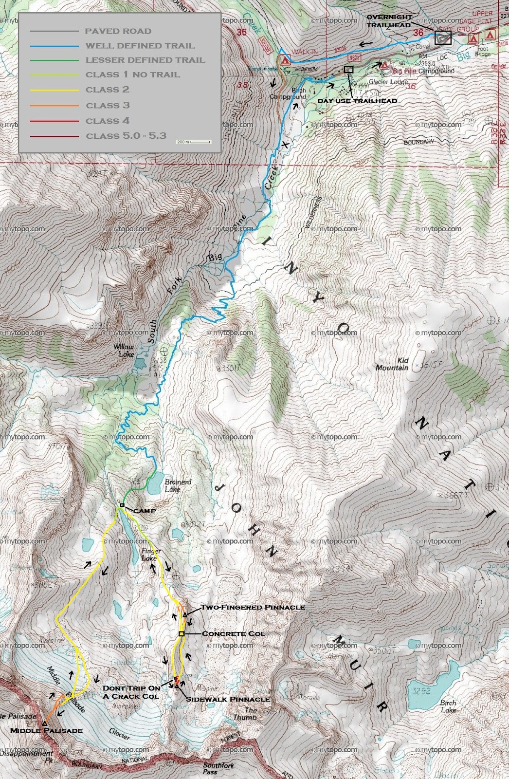
The four of us started hiking from the overnight trailhead (7,680 ft) at Big Pine Creek at around 8am Saturday morning. Most people would walk 0.7 miles up Glacier Lodge Rd from the overnight trailhead to the actual Big Pine Creek (day use) Trailhead, but instead we made the mistake of walking up the North Fork Trail and did a lengthy detour in order to reach the South Fork Trail (which we wanted). The South Fork Trail heads in a general southwestern direction for for 3 miles before ending at Brainerd Lake (10,250 ft). We walked along the western side of the lake for a few hundred feet before taking a series of steep but easily discernible use-trails which headed up a slope southwest of Brainerd Lake. The use-trails brought us up to a large flat spot near the outlet of Finger Lake (10,810 ft), where we set up camp.
Middle Palisade seen from a few miles in

first view of Two-Fingered Pinnacle shortly before Willow Lake (9,550 ft)
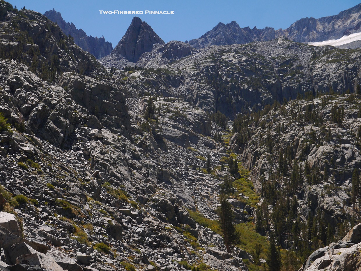
We had reached Finger Lake at 2pm, giving us 5 hours of remaining daylight. After setting up camp and eating lunch, I decided to check out a pinnacle about 0.7 miles to the southeast, which I had noticed earlier during the hike in. I headed up the broad class 1-2 ridge east of Finger Lake which headed southeast, paralleling the Lake. Eventually a large mound of class 3 rocks rose up in front of me, and I climbed up onto it finding the climbing highly enjoyable.
Finger Lake

on the broad ridge east of Finger Lake

looking southeast

class 3 finish to Two-Fingered Pinnacle

The highpoint was a ~10 ft class 3 (maybe low 4th) pinnacle with a smaller boulder a few feet to its south side. I was able to surmount the highpoint by climbing up onto the smaller boulder and stepping across the gap in between. The summit provided a broad panoramic view of the peaks from The Thumb all the way to Buck Mountain. I was not surprised to see that the Middle Palisade Glacier had receded at least a hundred feet since I had last been in the area in June 2012.
view northwest from Two-Fingered Pinnacle

southwest

south

southeast

Two-Fingered Pinnacle seen from the south


To the south along the same ridge I was on, I could see another more impressive looking rock formation which I later dubbed "Sidewalk Tower." With 3.5 hours of sunlight remaining, I decided to go for it.
The descent along Two Fingered Pinnacle's south ridge was straightforward class 1-2. Shortly after passing the lowpoint between Two-Fingered Pinnacle and Sidewalk Tower (Which I had dubbed "Concrete Col"), the ridge narrowed to about 5-10 feet wide. While the top of the ridge was comprised of mainly large flat blocks, the sides of it dropped straight down into large moraines. The ridge resembled a sidewalk in the sky, and it was very interesting to say the least.


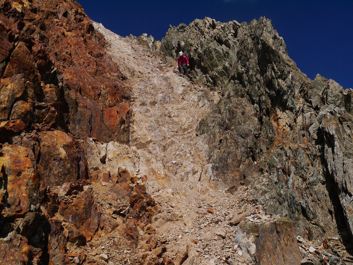
At first, it looked like the "sidewalk" would connect onto Sidewalk Pinnacle's north ridge, but just before it did, a large 25 ft deep crack appeared in the sidewalk, dropping down to a narrow col which I dubbed "Don't Trip On A Crack Col." At first I tried downclimbing directly to the col, but the lack of holds stymied me almost instantly. I climbed back up to the sidewalk and retraced my steps, walking back about 100 ft to find a class 4 ledge/crack/chimney system which dropped off the east side of the ridge. I downclimbed about 70 ft to the moraine below, and paralleled the ridge south until I was right below Don't Trip On A Crack Col. From there, a multitude of class 3-4 options led back onto the ridge on the south side of the col. All this work just to gain 15 ft of linear distance!
cliffing out at the crack

my downclimb off the ridge

Don't Trip On A Crack Col seen from the east

getting back onto the ridge

Once on the ridge, I dropped a few feet to the right (west) to bypass a large flake/pinnacle on the ridge, then began ascending Sidewalk Pinnacle's north ridge. The initial 30 ft-or-so involved climbing up the ridge along its left side on solid class 5.3-5.4 rock. One of the moves involved a foot smear which felt a little sketchy in my clunky boots, but at least the handholds were somewhat decent. Above the 30 ft section, the ridge flattened and briefly turned to class 3. A few moves up a cracked class 3-4 face brought me to the base of the 15 ft summit block which required a few fun mantle moves to surmount.
bypassing the flake/pinnacle before the north ridge

start of the north ridge


class 3-4 cracked face below the summit block

summit block

view ESE from summit

NNW

I remained at the summit for a little while, still amazed at the interesting little climb I had just done. To get back down, I descended north from the small but obvious notch just before the cracked face, and onto the moraine below, then paralleled the ridge north on loose cruddy rock before crossing over to the west side of the ridge via Concrete Col, rejoining my ascent route. From there, I retraced my steps to Finger Lake.
After what seemed like no time, I reached Finger Lake to find the others just finishing up their dinners. While I was gone, two other climbers who we knew (Jim and James) had passed our camp on their way down from their dayhike of Middle Palisade. They had mentioned that the conditions on the mountain were dangerous due to the fact that the Middle Palisade Glacier had receded about 15 ft, making the transition from the glacier onto the mountain difficult. It had taken them roughly an hour to make the transition. They also noted that the Red Rock Route (an alternate route to the north which does not involve the glacier) looked like very loose and dangerous class 4 terrain, which surprised me since everyone who I had talked to who had climbed it before referred to it as a class 3 route.
I crawled into my bivy sack and ate a few strips of jerky, then was fast asleep a few short moments after. The night would be very pleasant and warm, and before I knew it our 4am wake up time had arrived.
At 4am, I saw the light in Bill's tent come on. Everyone was somewhat awake. Hiroko was feeling sick and decided to forgo the climb. Sung seemed indecisive and did not know if she wanted to go for it. I decided to wait for a few moments to see if anything would change. At around 5am, I mentioned that I might go for another peak and Sung suddenly decided to go for Middle Palisade, so we grabbed our daypacks and began walking within 10 minutes.
We crossed the outlet of Finger Lake and headed in a general SSW direction towards the Middle Palisade Glacier, rock hopping across an old semi-solid moraine.
below the Middle Palisade Glacier

As the sky began lighting up and everything around us became more visible, we aimed for the screeish "rib" which divided the two portions of the Middle Palisade Glacier, then followed the rib upwards to the base of the standard route. 2012 route photo
At the top of the rib, we headed to the left onto the glacier, slipping and sliding across ~200 ft of glacier to find a ramp to the right. This ramp used to be class 3 all the way, but ever since the glacier had receded, the first 15 ft of ramp was class 4. The ramp led up to a notch containing a few large cairns, at which we turned left into a large broad gully which would take us up to the summit.
Norman Clyde Peak at sunrise


looking up from the scree rib

southern half of the glacier

looking towards the base of the Red Rock Route

second half of the standard route ramp

crevasses!

The gully was as every bit as fun as I had remembered it. Most of the rock was nicely solid. We could see the summit above us, just to the left of the notch at the top of the gully.


The summit came fairly quickly. Sung was very happy that she had finally made it. We sat down behind some rocks to shelter from the wind, and munched on snacks while reading through the register entries.
Middle Palisade summit


register

looking down at my previous day's efforts

We decided to descend via the Red Rock Route since it had looked interesting. We descended to a large gendarme at 13,000 ft which divided our ascent chute and another chute to the left. We branched off into the left chute, descended a few hundred feet around the gendarme, then hooked a sharp right at the base of the gendarme and descended an obvious band of red rock. According to Jim and James the previous day, this was the rock band which they thought looked class 4. It was a little loose in places, but it turned out to be no harder than class 3. At the base of the rock band, we reconnected with our ascent route at the scree rib and retraced our steps back down the mountain.
branching off for the Red Rock Route


red rock band

looking back at Middle Palisade from the moraine

almost back to the trailhead

Final Stats
16.4 miles
8,710 ft gain/loss
Weather Forecasts
Trailhead
Finger Lake
Middle Palisade (Middle Palisade has an elevation of 14,012 ft. Keep in mind that this forecast is for 12,992 ft)
Peakbagger Pages
Two-Fingered Pinnacle
Sidewalk Tower
Middle Palisade
Summitpost Pages
Middle Palisade
Northeast Face
Other
High Sierra Topix message board
Inyo National Forest
No comments:
Post a Comment