
July 5, 2014
Bear Creek Spire is one of the premier rock climbing crags in the Sierra, containing three classic routes: the Northeast Ridge (III, 5.4-5.5), North Arete (III, 5.8), and East Arete (IV, 5.8). Adam and I headed over to climb the North Arete, a striking feature which forms a large granite pillar seemingly plunging straight down the north side of the mountain. The entire route contained amazingly sticky rock and comprised of several flakes, fins, and chimneys.
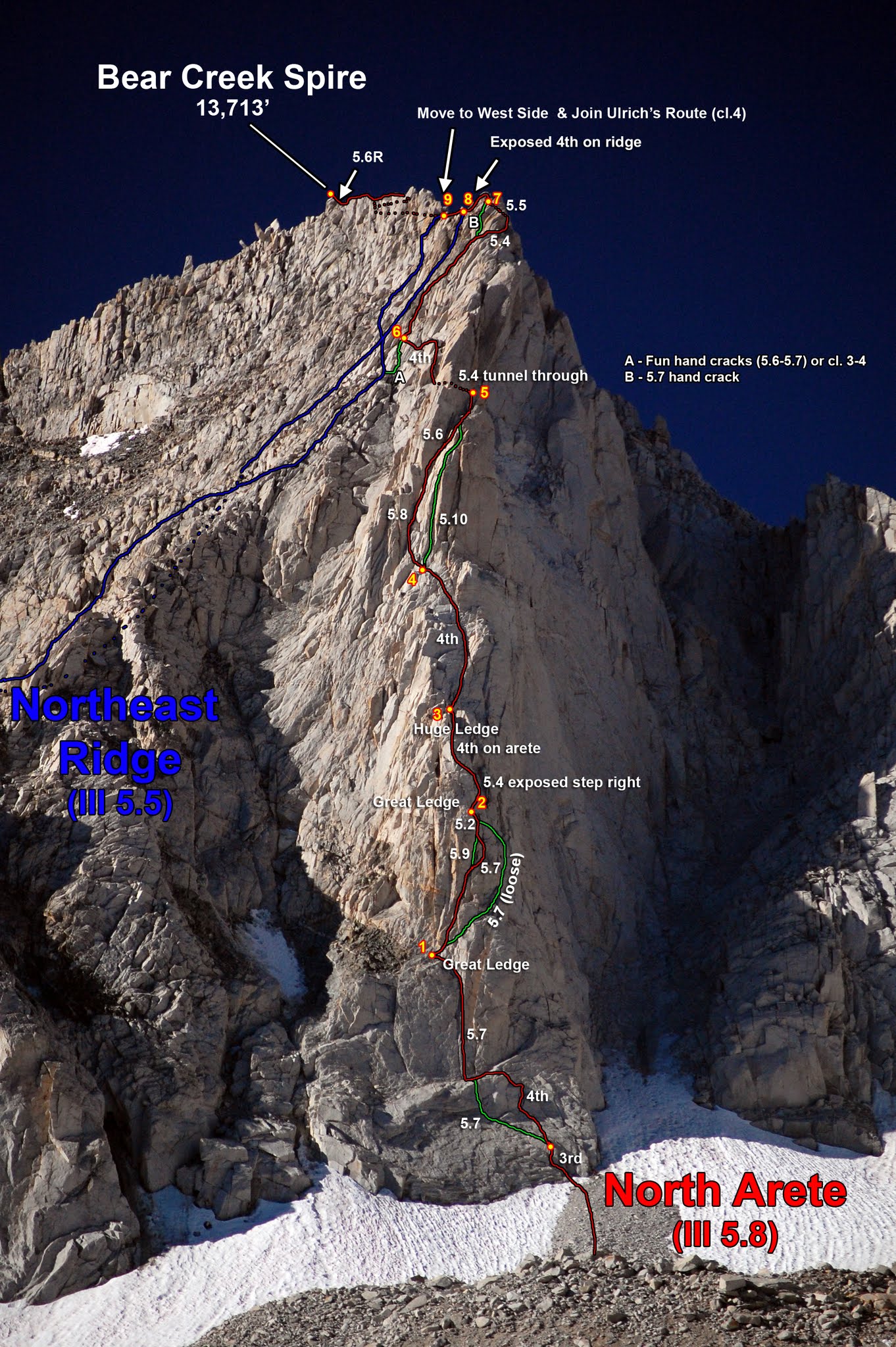
North Arete route summary (photo & annotations by Mark Thomas)
| Peak | Elevation | Topographic Prominence | Summit Coordinates (lat/lon) |
|---|---|---|---|
| Bear Creek Spire | 13,720 ft | 1,480 ft | 37.368012, -118.767505 |
After spending a night at Mosquito Flat Trailhead (10,230 ft), we hit the trail at around sunrise, heading in a general southern direction up Little Lakes Valley. In 3.5 miles, we hit a trail junction with the left trail heading towards Morgan Pass and the right trail heading towards Gem Lakes. We took the Gem Lakes turnoff, stayed on it for about 0.2 miles, then began cross countrying south up a large drainage from the south side of the second Lake.
above the highest Gem Lake

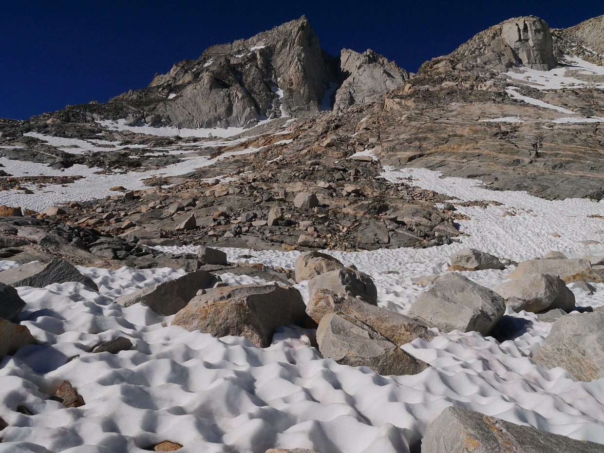
The terrain would now consist of rock hopping until the base of Bear Creek Spire. Upon reaching a small tarn (11,345 ft) not far above Gem Lakes, we headed slightly to the right (southwest) up the main drainage towards Dade Lake (11,600 ft).


Dade Lake


From Dade Lake, the giant pillar which made up the North Arete was very obvious, and we made our way directly towards it, heading in a general southern direction. Closer to the mountain, the rock hopping became mixed in with sections of slippery slabs which were flowing left and right with water.

The base of the North Arete was marked by a giant almost-vertical slab. Some people may rope up for this section, but we did not. There were many ways to climb up this slab and onto a giant belay ledge where the first pitch begins (our route is shown below), all of them at least class 4.

P1 headed up a large 5.7 crack split by two gigantic vertical slabs. This crack was mostly made up of flakes.

From the great ledge above P1, three prominent cracks appeared above us. We ended up taking the rightmost one which wrapped around the right side of the mountain. The first half of P2 (the crack) was rated 5.7, but it felt more difficult due to the off-width nature of the crack and a multitude of fins which stuck out in the way. As the crack ended at a small notch, we veered left up a broken face (5.2) to a huge ledge. We ended up dividing P2 into two smaller pitches at the notch due to rope drag.
first half of P2

second half of P2

Pitches 3 & 4 (class 4) headed directly up the arete to a wall split by three major cracks (the leftmost one was not visible at first).

We ended up taking the leftmost crack (5.8) which was the crux. Like the first half of P2, this crack was also off-width and full of fins and awkward nubs.
P5 cracks


view of Mt. Tom

The last 30 ft of P5 contained a fun chimney. The topo had rated it 5.6, but it felt more like a low 5th.

P5 ended at a large bolder-strewn ledge. To the left was a small 5.4 mandatory tunnel-through. We had to take off our packs in order to make this move. The tunnel spit us out an a upward-sloping ledge, which we followed up and to the right onto the main ridge. This is where the North Arete meets up with the Northeast Ridge. We put away the rope and made the scramble up this exposed ridge, keeping the climbing to 5.4 at most.
P6 tunnel

looking through the tunnel

upward sloping ledge which heads up to the ridge

The ridge contained a multitude of fins and blocks, making for a very fun scramble.


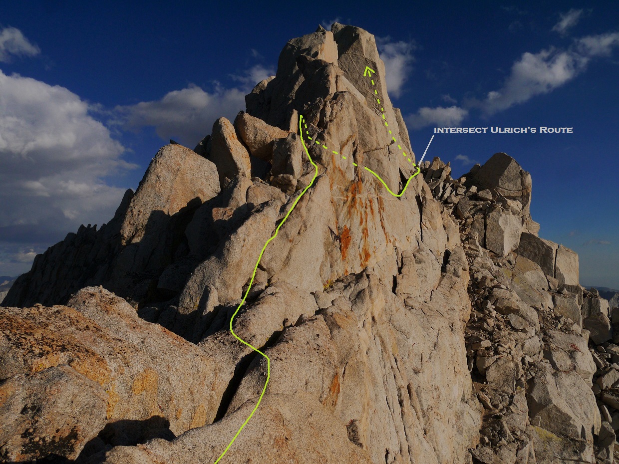
As the ridge steepened to a wall, we took a narrow ledge which traversed ~50 ft along the right (west) side of the ridge to a small rocky notch, intersecting the standard Ulrich's Route. The ledge we took was the higher of two ledges which lay roughly 15 ft apart from eachother. At first glance, this ledge looked sketchy with no handholds, but there was a very grippy undercling flake which extended across half the length of the ledge.
looking across the higher ledge

Adam traversing the higher ledge

view from the rocky notch

another group making their way to the ledge


From the notch, the cracked face of Ulrich's Route (class 4) lay directly above to the left. There were many ways to climb it. Once up the face and on the ridge, the summit block lay a short distance to the right.

The summit block contained an exposed 5.6 mantle move on its right side. Since the move was very short, it felt much easier than 5.6.

summit views


A few feet before the summit block, we found some rappel slings on the west side of the ridge, and rigged a short ~40 ft rappel to the rockfield below.

Once down, we remained there for a few moments to watch the sunset.


After rappelling down, we headed in a general northwestern direction, slogging down a broad gully, then paralleling the Northeast Ridge of Bear Creek Spire to Cox Col: the lowpoint between Bear Creek Spire and Pipsqueak Spire (the next peak along the crest). From Cox Col, we descended a short section of loose cruddy terrain (mostly hard packed sand) to the east, then headed northeast towards Dade Lake to retrace our steps back to the trailhead, arriving at around 12am.
Final Stats
11.7 miles
4,340 ft gain/loss

Weather Forecasts
Mosquito Flat trailhead
Gem Lakes
Bear Creek Spire
Peakbagger Pages
Bear Creek Spire
Summitpost Pages
Bear Creek Spire
North Arete
Other
North Arete (Mountain Project)
North Arete (Supertopo)
High Sierra Topix message board
No comments:
Post a Comment