
March 8, 2014
Needle and Manly are two prominent peaks on the southern side of the Panamint Mountains, a 100 mile long range bordering the western side of Death Valley. Both peaks were relatively short walk-ups, but they offered nice expansive views of the surrounding desert.
| Peak | Elevation | Topographic Prominence | Summit Coordinates (lat/lon) |
|---|---|---|---|
| Needle Peak | 5,801 ft | 1,652 ft | 35.886394, -117.028668 |
| Peak 4117 | 4,117 ft | 295 ft | 35.907075, -117.05467 |
| "Mengel Peak" | 5,449 ft | 381 ft | 35.902904, -117.091556 |
| Manly Peak | 7,195 ft | 2,553 ft | 35.915064, -117.116945 |
Getting to the trailheads (route 1) 4WD required
Getting to the trailheads (route 2) 4WD required
Needle Peak, Peak 4117 trailhead coordinates (lat/lon): 35.910909, -117.059330
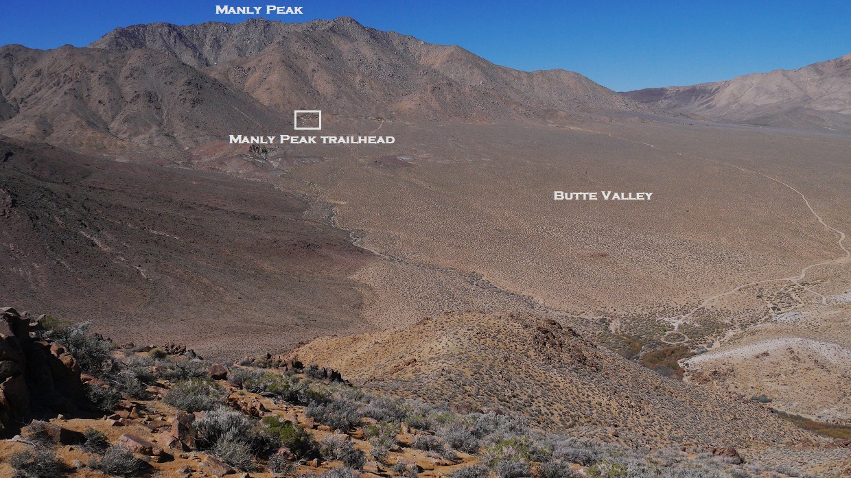
Mengel Peak, Manly Peak trailhead coordinates (lat/lon): 35.913144, -117.088780
Sung, Dagmar, Craig, Tommey, and I had spent a pleasant night camped at Willow Spring (3,590 ft), the trailhead for Needle Peak. As far as we could see, there was no sign of the spring, but it easily could've been hidden behind the numerous bushes in the area. The next morning, we began hiking from the trailhead at 7:30 am, hiking around to the south side of Peak 4117 which lay immediately south of Willow Spring.
trailhead view

From the south side of Peak 4117, we were able to gain a view of Needle Peak. The actual summit itself was not visible, but most of the remaining route to it was visible. From the south side of Peak 4117, we cross countryed east to intersect a prominent wash (see map) west of Needle Peak which ran in a south-north direction.
entering the wash

Once in the wash, we followed it south until it ended at a saddle (4,640 ft). From that saddle, we headed east up a short section of steep and loose class 2 terrain to gain Needle's west ridge.

reaching the west ridge

Once on the west ridge itself, we followed it east towards Needle Peak. The terrain was soft and easily negotiable. Along the way, we passed up and over a false summit a short distance west of Needle.
first view of Needle Peak

views from west ridge

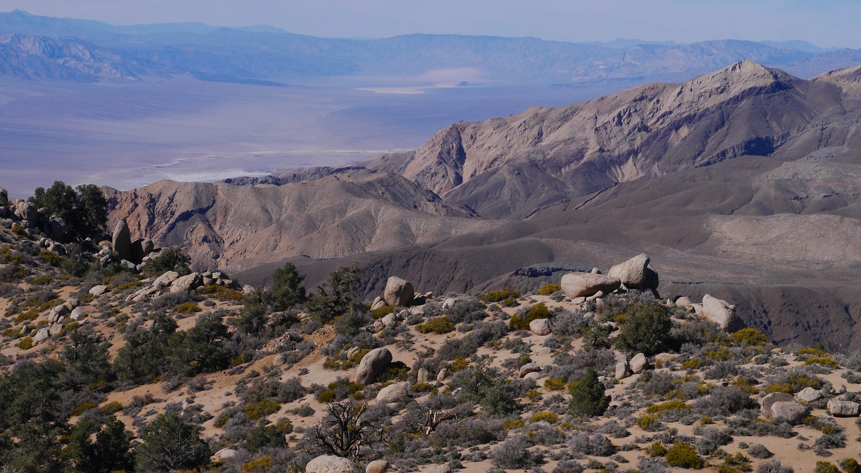
At the summit, we took a short snack break. It was a remarkably clear day with spectacular views in all directions. To the east was the deep valley which contained Lake Badwater, bordered by steep terrain on all sides. To the northwest was the large, dominating profile of Manly Peak. We were even able to clearly make out the snow-capped summits of the San Bernardino and San Gabriel Mountains to the south, which were over 100 miles away!
views from Needle Peak


benchmarks

From the summit of Needle, we retraced our steps back to the trailhead. Instead of walking back around Peak 4117, I decided to go over it just for the hell of it. There was nothing really exciting about this peak, but a peak is a peak!

view of our route up Needle from the south slope of Peak 4117

view east from the summit of Peak 4117

northwest
We were back at the Needle Peak trailhead before noon, and headed right on over to Russell Camp, the trailhead for Manly Peak.
Russell Camp

From Russell Camp, we headed up a broad canyon to the southwest to a saddle at 5,060 ft. This canyon contained several sandy use-trails.
looking southwest from Russell Camp

From Saddle 5,060 ft, the route to Manly was very simple: Head up the ridge to the northwest, and follow it to the highpoint.
The topo map indicated a smaller peak with 381 ft of prominence about 0.4 mi SSE of Saddle 5,060 ft. Since this peak was so close, I decided to check it out. I headed up the ridge south of Saddle 5,060 ft, and followed it up and over a few bumps to the summit of Peak 5449, which I later dubbed "Mengel Peak" since it bordered the western side of Mengel Pass.


The summit of Mengel Peak was marked by a metal survey stake and benchmark.


views from Mengel Peak


After a minute or two on Mengel Peak, I headed back to Saddle 5,060 ft and up the ridge to Manly Peak. I found the ascent up Manly surprisingly pleasant and sandy.

views from the ascent up Manly


Manly's summit block was an interesting 20 ft high hunk of granite. We had brought along some ropes for this block, and didn't really need them, but had brought them in order to practice roped climbing. The easiest route up the block was a class 3+ crack on its western side.


summit views

After each one of us had stood on the summit, we spent a little over an hour playing around with the ropes and practicing anchor setups. As it started getting late, we packed up our toys and headed down the way we had come, enjoying the nice sandy descent. There was some magnificent lighting on the way down, and I stopped numerous times to snap photos.


Stats for Needle Peak and Peak 4117
6.3 miles
3,050 ft gain/loss

Stats for Mengel Peak and Manly Peak
5.9 miles
3,340 ft gain/loss

Weather Forecasts
Trailheads
Needle Peak
Manly Peak
Peakbagger Pages
Needle Peak
Peak 4117
Mengel Peak
Manly Peak
Other
Death-Valley.net Forum
Death Valley National Park
No comments:
Post a Comment