
February 14, 2014
Keynot Peak and Mt. Inyo are the second and third highest points in the Inyo Mountains, a ~70 mile long range that runs in a north-south direction, parallel to a portion of the southern and central Sierras. Often times people hike up into the Inyo Mountains not because of the mountains themselves, but in order to attain grand views of the Sierra Crest to the west.
The standard approach for Keynot and Inyo is to ascend the ridge south of Union Wash to Bedspring Saddle (see map), then climb both peaks from the the saddle before heading back down the same way. Due to a series of reports stating that the standard route was a tedious scree slog, we decided to ascend a prominent ridge (the second ridge south of the standard ridge) that would lead us directly to the summit of Keynot. Along the way, we would ascend up and over Forgotten Point, the biggest bump on the ridge. Because of this, I will dub this ridge "Forgotten Ridge" for this trip report. From Keynot, we would traverse along the connecting ridge to Inyo, then head down via the standard route.
| Peak | Elevation | Topographic Prominence | Summit Coordinates (lat/lon) |
|---|---|---|---|
| Forgotten Point | 8,395 ft | 200 ft | 36.693497, -117.984786 |
| Keynot Peak | 11,101 ft | 3,050 ft | 36.707586, -117.962623 |
| Mt. Inyo | 10,975 ft | 955 ft | 36.735229, -117.985686 |
Getting to the trailhead: From the North end of Lone Pine, go north on 395 1/2 mile and head east on Lone Pine Narrow Gauge Rd (also abbreviated NPLG Rd on some of the signs.) Head east for approx 3 miles staying on the paved road until you get to a "Y" intersection where you will head north for 5 miles on a well graded dirt road. At this point, look for a notch incut into the dirt berm on the east side of the road. You should now be able to see a road heading up Union Wash. Take this road for approximately 1.5 miles to the foot of Forgotten Ridge. When we were there, we found the road to be 2WD compatible. (these directions are a modified version of those provided on Summitpost)
Trailhead coordinates (lat/lon): 36.704350, -118.032189
Tommey and I started hiking sometime around 4:30 am under a full moon, walking up Union Wash along the road. The surrounding terrain was lit up so brightly that we did not need to use our headlamps. Due to what looked like cliff-outs at the foot of Forgotten Ridge, we continued up the road for a short distance, then climbed up onto the ridge along its side on a steep and loose scree slope. Later that day while on the descent, we saw that the foot of the ridge did not contain cliff-outs, and would recommend starting there. Once on the ridge itself, the terrain became gentle and easygoing. As the sky began lighting up, we could see that it was covered in a layer of high clouds.
Shortly after sunrise, the sun broke through the layer of clouds for a few minutes, washing the Sierras in a magnificent alpenglow.


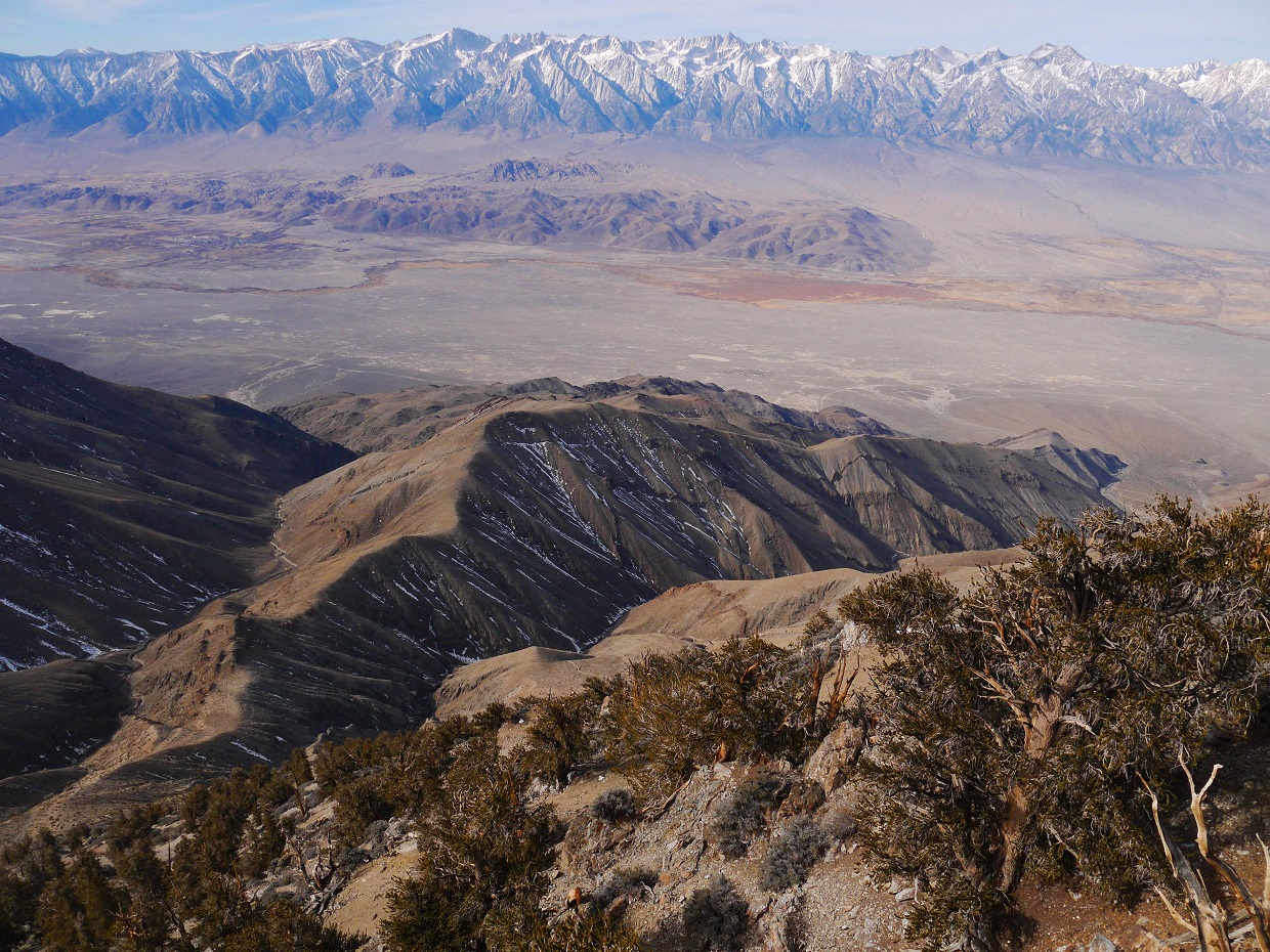
We took a short break on Forgotten Point, gazing over at the Sierras and at the remaining distance between us and Keynot Peak. The remainder of Forgotten Ridge steepened and merged into the Southeast Face of Keynot Peak, eventually resembling one of many ribs that seemed to cascade down the face.
view northeast from Forgotten Point

continuing along Forgotten Ridge


As the ridge merged into Keynot's Southwest Face, the terrain became made up of hard packed compacted scree. A few hundred vertical feet higher, the ground turned into a mix of sandy scree for the remaining distance to Keynot's summit. We would occasionally drop into a shallow gully to the right of the ridge, finding only slightly better quality terrain. Even though the terrain was cruddy, the ascent afforded no shortage of good views.


bleh


We reached the summit of Keynot at around 10am, finding no register at the summit, but did however manage to locate a colony of ladybugs.

view southwest from summit

peak trivia

south-southeast

Shortly after we began the traverse to Inyo, we located a benchmark. What it was doing several hundred feet from the summit, I had not a clue.

traverse to Inyo

As we descended Keynot, we found the east side of the ridge covered with deep unconsolidated snow, so we moved over to the west side where there was little to no snow. Staying on top of the ridge was not an option as it was coated with black ice in some spots. The west side contained a jumble of loose rock and bushwhacking, which made progress tedious and slow going. The terrain was mostly class 2, requiring occasional class 3 moves. Luckily this terrain was short lived, and before long we found ourselves on a broad gentle ridge descending smoothly towards Bedspring Saddle (10,100 ft).


From Bedspring Saddle, we ascended up and over a small bump, dropping down the other side to another saddle at 10,040 ft- the lowpoint between Keynot and Inyo. The ascent up to Inyo was pretty straightforward. We headed up the slope north of Saddle 10,040 ft to the first bump. Since the highpoint of Mt. Inyo was at the end of a succession of false summits, we dropped slightly to the left and contoured along the west side of the ridge to avoid those false summits. After passing by two false summits, the highpoint of Inyo came into view.

We arrived at the summit of Inyo at around 2pm, finding a propped up stick that marked the highpoint, but no benchmark or register.
view southeast from summit

While descending Inyo, I could'nt help but gaze at the gigantic north face of Keynot. From no other angle that day did Keynot look so asserting.


To get back down to the trailhead, we descended via the standard route, descending the ridge south of Bedspring Saddle that branched out eastward.
views from descent


After descending the ridge for roughly 0.7 miles on relatively gradual terrain, the terrain suddenly steepened below a bump on the ridge at 9,155 ft (labeled on the Topo map as "9155T"). Though a trail could be seen contouring around the south side of Point 9,155 ft, we climbed onto the bump to see what was on the other side. Once there, we looked down and saw an awesome scree slope which met up with the trail further down the ridge. We gladly heel plunged down through the scree, taking around 15 minutes to descend 1,000 ft of elevation.


After intersecting the trail and following it for a short distance, we located another scree field heading directly down into Union Wash, and happily heel plunged down. While descending, we would occasionally intersect some faint switchbacks.


In what seemed like no time at all, we found ourselves standing in Union Wash. We hiked through the wash to the eastern tip of the standard ridge where a rough dirt road appeared, and followed the road back to the trailhead.
the drop into Union Wash (For those ascending via the standard route, either start at the foot of the ridge or ascend this gully)

our descent route viewed from a spot further east down Union Wash

Final Stats
13 miles
8,550 ft gain/loss

Weather Forecasts
Trailhead
7,180 ft
Keynot and Inyo
Peakbagger Pages
Forgotten Point
Keynot Peak
Mt. Inyo
Summitpost Pages
Keynot Peak
Mt. Inyo
Other
Inyo Mountains Wilderness
Thank you for supplying such a detailed and well-photographed (and well-described) narrative.
ReplyDeleteI'd like to hike up to somewhere like Forgotten Point and sleep there so I can wake up and watch the sunrise. Do forgotten point or point 9155 have any area of flatness at all?
ReplyDelete