November 9, 2013
With the days getting cooler, it was time to begin climbing desert peaks. Craig, Sung, Tommey, and I origionally planned to climb Tucki Mountain in Death Valley, but found the road into Skidoo closed upon arrival. We switched to plan B, which involved two peaks in the Cottonwood Mountains: Towne Benchmark and Panamint Butte. The Cottonwood Mountains are a desert range on the western side of Death Valley running in a north-south direction. Being not far off Towne Pass, Towne Benchmark is a fairly popular hiker destination. Panamint Butte attracts fewer visitors, but it still receives a good handful of visitors by being listed on the Sierra Club Desert Peaks Section (DPS) list.
| Peak | Elevation | Topographic Prominence | Summit Coordinates (lat/lon) |
|---|---|---|---|
| Towne Benchmark | 7,287 ft | 2,347 ft | 36.419839, -117.318241 |
| Peak 6500 | 6,500 ft | 360 ft | 36.426341, -117.340164 |
| Panamint Butte | 6,584 ft | 524 ft | 36.433946, -117.355975 |
Getting to the trailhead: From Olancha, travel 59 mi on CA-190 East to Towne Pass.
Trailhead coordinates (lat/lon): 36.399071, -117.280425
The four of us left Towne Pass at 8am, climbing up the side of a ridge that bordered the west side of Towne Pass.
Upon reaching the crest of the ridge (5,750 ft), Towne Benchmark was visible to the northwest. We turned north (right) and followed the gentle undulating ridge to Towne's summit. No difficult routefinding was required.
Along the way, there were several incredible views into Dolomite Canyon.
We located numerous survey markers marking the boundary of Death Valley National Park. These markers would appear at about every tenth of a mile along the ridge.
more views
Albatross plane crash more info
last few hundred feet below to Towne Benchmark
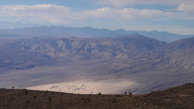
We reached the summit of Towne Benchmark at 11am. Even though the day was slightly hazy, the Sierras were clearly visible towards the west across the impressive Panamint Valley.
view south
southwest
west
northwest
benchmark
oldest register entries
From Towne Benchmark, there were two ways to get to Panamint Butte. The first option was to drop northwest into Panamint Canyon, then pick up a ridge branching southeast off Panamint Butte. The second option was to follow a soft ridge north to its northern highpoint (which I will refer to as "Point 7,290 ft"), drop down southwest to a saddle between Point 7,290 ft and Peak 6500, pick up Peak 6500's Northeast Ridge, and follow it as it curves in a semicircular direction to hook up with Panamint Butte.
We decided to go with the second option, which involved much more distance that the first option, but much less elevation gain.
looking north along the soft ridge to Point 7,290 ft
views from soft ridge
view southwest from Point 7,290 ft
The drop down to the saddle between Point 7,290 ft and Peak 6500 contained loose and crumbly class 2 rock on steep slopes. The last few hundred feet of drop contained a few short and loose class 3 bands of rock.
looking back towards Point 7,290 ft from saddle
views from Peak 6500's Northeast Ridge
Peak 6500's summit area contained the remnants of some old wooden structure. There was a clear view of our route to Panamint Butte, which lay to the northwest.
The ridge between Peak 6500 and Panamint Butte contained a straightforward walk-up. Along the way, I climbed to the top of a bump south of Panamint Butte. The map indicated that this bump hung directly over Panamint Valley, likely resulting in amazing views of the valley.
views from the ridge between Peak 6500 and Panamint Butte
The views from the bump south of Panamint Butte were indeed magnificent.
From the viewpoint, it was a quick 10 minute walk over to Panamint Butte, which did not have much in terms of views due to its broad plateau-ish summit area.
From Panamint Butte, we headed east to the edge of the plateau, then dropped northeast via one of several soft ridges. Not wanting to climb back up the way we had descended from Point 7,290 ft, we aimed for a reddish ridge that branched off to the left (northwest) of Point 7,290 ft. Although this ridge contained some screeish sections, it was considerably better than our descent route from Point 7,290 ft.
late afternoon views from Point 7,290 ft
From Point 7,290 ft, we retraced our steps from Towne Benchmark and the trailhead, arriving back at the trailhead at 6pm.
Final Stats
15.7 miles
6,500 ft gain/loss
Weather Forecasts
Trailhead
Towne Benchmark
Peak 6500, Panamint Butte
Peakbagger Pages
Towne Benchmark
Peak 6500
Panamint Butte
Summitpost Pages
Towne Benchmark
Panamint Butte
Other
Death-Valley.net Forum


No comments:
Post a Comment