
November 2, 2013
Tachevah Ridge is a prominent spur ridge branching northeast off Skyline Ridge. The base of Tachevah ridge starts at an elevation of 600 ft, ascending 3.8 miles to its merge with Skyline Ridge at 5,000 ft, where the popular Skyline Trail is found. With all its ups and downs included, Tachevah Ridge gains a total of 5,100 ft by the point it reaches Skyline Ridge. There is no official or widely accepted name for this ridge, leading me to refer to it as "Tachevah Ridge" after a nearby canyon known as Tachevah Canyon. Along the ridge, there is a bump that sports 275 ft of topographic prominence, more than that of most named peaks in the San Jacinto Mountains. I will unofficially refer to this bump as "Tachevah Peak." There are two smaller bumps on the ridge which I will refer to as "Pipe Point" and "Flag Point" based on the items of junk that previous groups had left on their summits. These serve as reference points, much like how certain widely known landmarks such as "Flat Rock" and "The Traverse" serve on Skyline. The approximate mileages and elevation gains at certain points along Tachevah Ridge are as follows:
| Point | Elevation | Mileage up to this point | Elevation gain up to this point |
|---|---|---|---|
| Trailhead | 600 ft | 0 mi | 0 ft |
| Pipe Point | 2,698 ft | 1.6 mi | 2,250 ft |
| Flag Point | 3,242 ft | 1.9 mi | 2,750 ft |
| Tachevah Peak | 4,685 ft | 3.3 mi | 4,500 ft |
| Merge with Skyline Trail | 5,000 ft | 3.8 mi | 5,100 ft |
Keep in mind: Upon reaching Skyline Ridge, the Skyline trail ascends an additional 3,700 ft in 3.2 miles before reaching the upper station of the Palm Springs Aerial Tramway. A one-way tram ride down the mountain costs $12, and the ticket agent can arrange a taxi ride back to the trailhead. Descending Skyline is strongly not recommended when this forecast calls for temperatures exceeding 85°F.

Getting to the trailhead: From Banning, travel 10 mi east on Interstate 10, then turn right onto CA-111. Travel 10 mi on CA-111 and turn right onto W Vista Chino (located 1 mi after the well-advertised entrance to the Palm Springs Aerial Tramway). Travel 0.6 mi on W Vista Chino, then turn right onto W Stevens Rd. Travel 0.3 mi on W Stevens Rd, then turn left onto N Rose Ave. Travel 0.2 mi on N Rose Ave, then turn right onto Viva Vadera. Travel 300 ft on Viva Vadera, then turn right onto Los Robles Dr. Travel 0.1 mi to the end of Los Robles Dr. This is a residential area, and there are plenty of parking spots along the sides of the street.
Trailhead coordinates (lat/lon): 33.841211, -116.560150
Sung and I left the trailhead shortly after 6am, headlamps ablaze. We would only need them for a short while as the eastern horizon was already showing signs of light. The base of Tachevah Ridge lay a few hundred feet north of the trailhead. The ridge ascended rapidly for the first 600 ft of gain, then leveled off a bit, turning into a series of small up-downs on semi-rocky terrain. Most of the terrain consisted of class 1-2 climbing. There were a few short and easy class 3 sections here and there, but they could all be easily avoided if one was uncomfortable with it.
looking back from 1,450 ft on the ridge

looking towards Pipe Point from 1,600 ft

rock graffiti at 1,700 ft

some easy scrambling


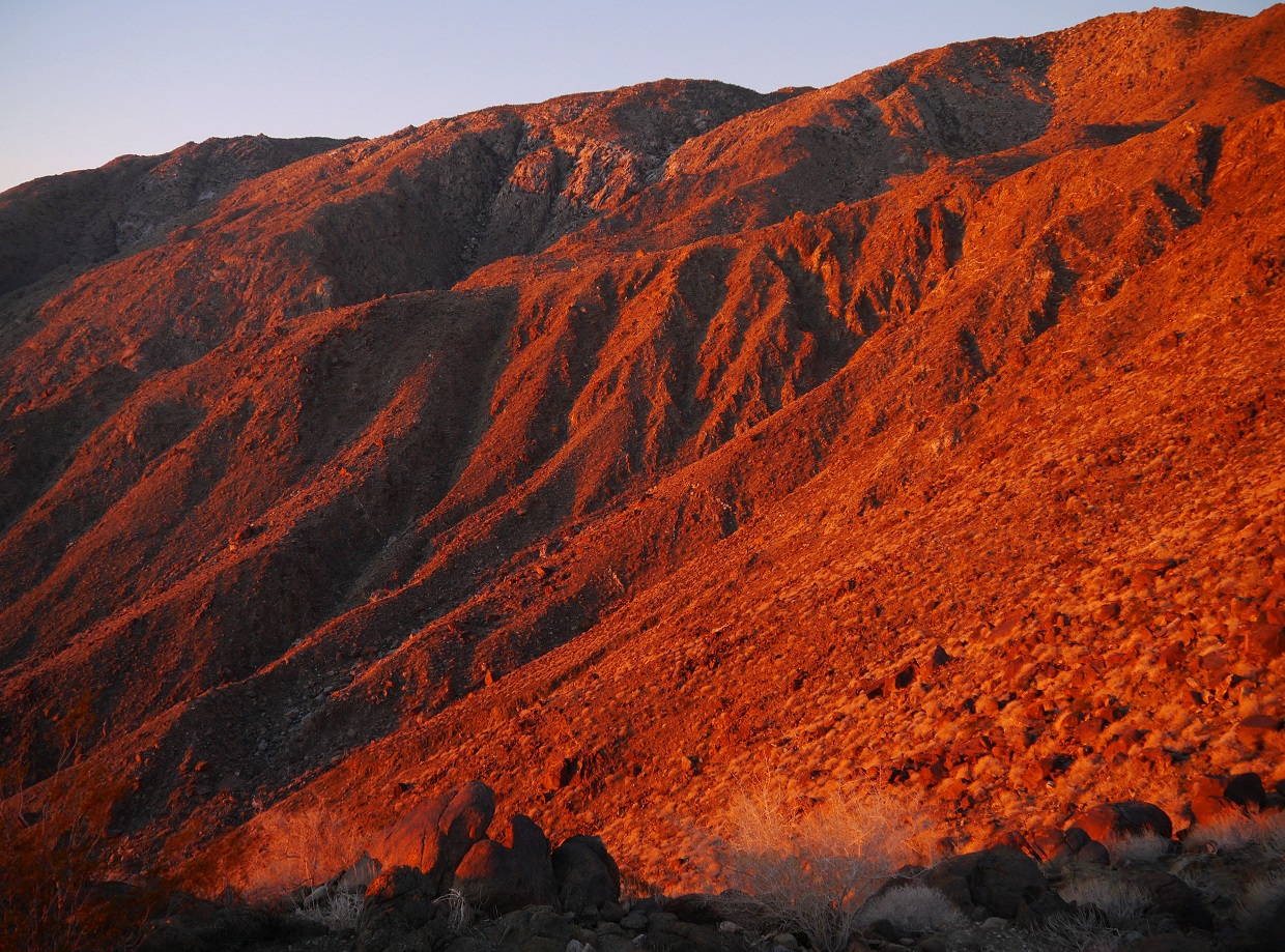
One thing I really enjoy about San Jacinto's eastern ridges are its vividly red desert sunrises. Each ridge contains its own unique sunrise view.
looking up Tachevah Ridge from 2,000 ft

looking northwest towards Leatherneck Ridge

Skyline Ridge to the south

more views


last stretch before Pipe Point

Leatherneck Ridge


the pipe marking Pipe Point (2,698 ft)

our progress viewed from Pipe Point

approaching Flag Point (3,242 ft)
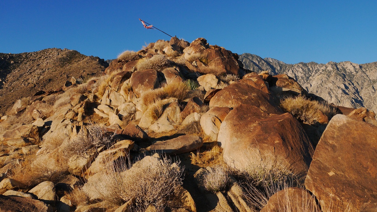
tattered flag on Flag Point

view northeast

southwest

From a saddle southwest of Flag Point, the ridge leading up to Tachevah Peak was a steady uphill slog on generally sandy terrain. A few sections of light bushwhacking appeared here and there.


brief rocky section shortly before Tachevah Peak


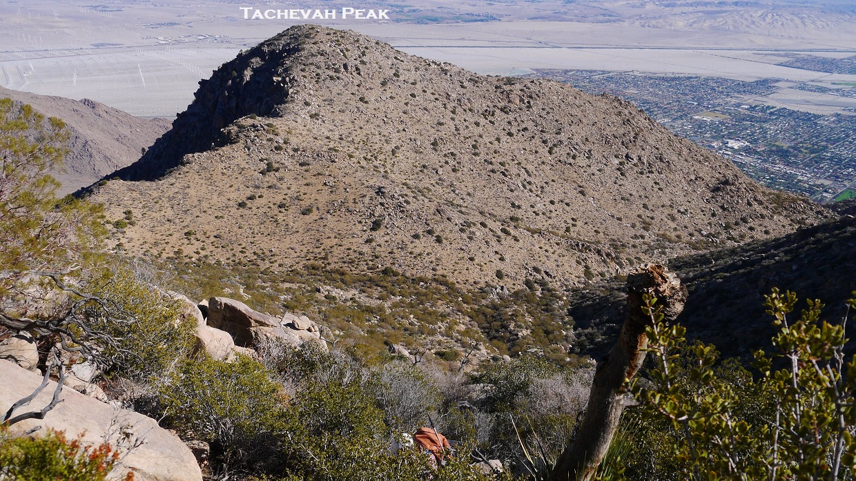
Tachevah Peak's summit (4,685 ft) was broad and plateau-ish, containing several patches of yucca. A small cairn had been erected at its highpoint. The remainder of Tachevah Ridge to its merge with Skyline Ridge was visible to the southwest.
view northeast from Tachevah Peak

east

southwest

From Tachevah Peak, we descended a few hundred feet to a saddle separating Tachevah Peak and Skyline Ridge, then contoured our way to Skyline Ridge. The last quarter mile of this contour contained some moderate bushwhacking.
view from saddle

bighorn sheep bones found near the saddle

moderate bushwhacking

intersection with the Skyline Trail (5,000 ft)

After reaching Skyline, Sung and I split off and hiked at our own paces. Like on any Saturday in November, there were several groups hiking Skyline. I must have passed at least 20 people on the trail between the merge and Grubbs Notch. From the merge, Skyline ascends an additional 3,700 ft in 3.2 miles to the Long Valley Ranger Station.
views from Skyline

Coffman's Crag


Upon reaching Grubbs Notch (8,400 ft), the entry point into Long Valley, I turned right and walked the short distance to Long Valley Ranger Station to fill up on water and obtain a permit. The water was faucet water from the ranger station bathrooms, and it always tasted strongly of one substance: chlorine. I ate a quick snack, then began making my way up the trail towards San Jacinto Peak. I decided to take the Sid Davis Shortcut, an unmaintained trail that splits off from the main trail shortly after Long Valley Ranger Station, following the Sid Davis Drainage up to Tamarack Valley. After Tamarack Valley, it does a few switchbacks, then hooks back up with the main trail a little over a mile before San Jacinto Peak. As usual, I lost the trail shortly after Tamarack Valley, and found myself cross countrying southwestward towards the main trail. Upon reaching Miller Saddle, I decided to do the short scramble up to Miller Peak- a rockpile on the Northeast Ridge of San Jacinto Peak.
Miller Peak

From Miller Peak, I took a shortcut to San Jacinto Peak along its Northeast Ridge, following an old and unmaintained trail that seemed to disappear at times.
view of San Jacinto Peak from Miller Peak

I reached San Jacinto Peak at 2:35 pm, meeting up with several familiar faces from a nearby hiking club who had hiked the Cactus to Clouds trail. I laid down on a flat rock and took a nice nap as the summit area filled up with people. After Sung made her way up to the summit, we descended back to the upper tram station via the main trail (5.5 miles) with one of the Cactus to Clouds groups.
views from San Jacinto Peak


views from Wellman's Divide along the main trail


Final Stats
17 miles
11,700 ft/4,000 ft gain/loss

Weather Forecasts
Trailhead
Tachevah-Skyline Ridge merge
6,000 ft on Skyline Trail
Long Valley
San Jacinto Peak
Peakbagger Pages
Tachevah Peak
Miller Peak
Mt. San Jacinto
Summitpost Pages
Miller Peak
Mt. San Jacinto
Other
Mt. San Jacinto message board
Webcam at Long Valley Ranger Station
Palm springs Aerial tramway
No comments:
Post a Comment