
July 17, 2016
The eastern San Gabriel Mountains are no doubt one of the most popular hiking spots in the state, due to its easy access and proximity to the Los Angeles Basin. A network of trails spans up and over almost every 7,000+ ft peak in the region. While studying a map of the area, I came up with an idea to combine three classic eastern San Gabriel routes (see map): Iron to Baldy Traverse, Three T's (Thunder, Telegraph, and Timber peaks), and ECBO (Etiwanda, Cucamonga, Bighorn, and Ontario peaks), with the goal to complete the entire traverse in one push. The accumulated gain of this route totaled over 16,000 ft. There would also be a 50 minute car shuttle between the start (Heaton Flat) and finish (Icehouse Canyon).
| Peak | Elevation | Topographic Prominence | Summit Coordinates (lat/lon) |
|---|---|---|---|
| Iron Mountain | 8,007 ft | 707 ft | 34.249842, -117.743554 |
| San Antonio Ridge Peak | 7,758 ft | 391 ft | 34.2911, -117.6953 |
| West Baldy | 9,988 ft | 128 ft | 34.286847, -117.654709 |
| Mt. Baldy* | 10,064 ft | 6,244 ft | 34.289129, -117.646304 |
| Mt. Harwood | 9,552 ft | 172 ft | 34.286498, -117.63317 |
| Thunder Mountain | 8,587 ft | 367 ft | 34.265267, -117.605848 |
| Telegraph Peak | 8,985 ft | 1,183 ft | 34.26161, -117.5985 |
| Timber Mountain | 8,303 ft | 563 ft | 34.245198, -117.593608 |
| Cucamonga Peak | 8,859 ft | 1,279 ft | 34.222943, -117.585369 |
| Etiwanda Peak | 8,662 ft | 322 ft | 34.228397, -117.57251 |
| Bighorn Peak | 8,441 ft | 341 ft | 34.233785, -117.597449 |
| Ontario Peak | 8,693 ft | 1,039 ft | 34.227765, -117.624121 |
*The official USGS name for this peak is "Mt. San Antonio," but it has been so widely referred to as "Mt. Baldy" that I will refer to it as such in this trip report.
Gus and I met up at Icehouse Trailhead (4,982 ft) at 1am Sunday morning and proceeded to shuttle over to Heaton Flat. The plan was to complete the traverse in a clockwise direction since it meant more gain than loss, resulting in a better workout and happier knees. By 2am, we were walking the half mile dirt road from the parking area of Heaton Flat (2,030 ft) to the beginning of the Heaton Flat Trail. I had been on this trail a few years prior. Since then, the trail had become more overgrown and uneven, despite its popularity. Our first peak was Iron Mountain, which required over 7,000 ft of gain from Heaton Flat. We took the Heaton Flat Trail 4.2 miles to Allison Saddle (4,580 ft), a prominent dip on Iron's south ridge. From there, we took a well defined use-trail up Iron's south ridge, stopping once in the middle to grab a bite to eat. The ascent went easily and without a hitch, and by sunrise we were up and over the summit of Iron (8,007 ft), and on our way eastward along the connecting ridge to Baldy.
sunrise on Iron's summit


The descent of Iron's east ridge was characterized by light bushwhacking and mostly class 2 scrambling. The main trick here was to stay on the ridge, as leaving it would entail sidehilling on various slopes of nasty scree.


The most notable feature of the Iron to Baldy Traverse was Gunsight Notch (7,340 ft). The popular belief is that Gunsight marks the lowest point between Iron and Baldy, but this claim is false. The actual lowest point is one notch (7,290 ft) west of Gunsight. Getting to Gunsight involved a short section of class 3 downclimbing for the last 10-15 ft to the notch.
Gus descending to Gunsight Notch

Immediately after the notch, we began ascending the West Ridge of San Antonio Ridge Peak (7,758 ft), the most topographically prominent point between Iron and Baldy. This ridge was straightforward class 1-2. Use-trails would flicker in and out.
summit of San Antonio Ridge Peak


We proceeded along the ridge, soon hitting another bump (7,903 ft). This bump contained a register with "San Antonio Ridge 7903" written on it.
looking towards Baldy from Point 7903

The remaining ridge to West Baldy was a steep class 1 hike, gaining over 2,000 ft of elevation. There were some sections of buckthorn at first, but they could be mostly avoided by heading a little left on the ridge.


West Baldy was merely a bump on Baldy's west ridge. We took a food break just below it, then headed on over to Baldy.
summit of West Baldy

Baldy was a madhouse of what seemed like mostly Los Angeles hikers. There were people milling about everywhere. This was definitely not a "wilderness peak." We stayed on the summit for about a minute before descending a trail (Devils Backbone Trail) on the east side.

Next up was Mt. Harwood, which was really just another bump on Baldy's east ridge. A well defined use-trail headed up Harwood's west ridge and down its south slope.

looking back up Baldy from Harwood

After heading down Harwood's south slope, we were now walking down the Devil's Backbone Trail, which continued down Baldy's east ridge. This trail was a very well graded and crowded superhighway. Every few seconds we would run into someone. In no time at all, we had reached Baldy Notch (7,800 ft), the lowpoint between Mt. Baldy and Thunder Mountain. This notch was marked by a ski lift and restaurant. We headed over to the restaurant to fill up on water from a drinking fountain, and since we were somewhat hungry, we decided to remain there almost another hour and order food.
Devil's Backbone Trail


Baldy Notch in the foreground

Now rested and fed, we began trudging up Thunder Mountain, beginning the second part of this traverse. A fire road ascended the north side of Thunder, depositing us right on the summit which was marked by the top of a ski lift.

A few hundred feet west of Thunder was a sign marking the start of the Three Tee's Trail. We took this trail to the south ridge of Telegraph Peak, then took a well defined use-trail a short distance to Telegraph's summit.

views from Telegraph


Next up was Timber, the southernmost of the Three T's. We took the main trail to a short distance west of Timber, then took a short well defined use-trail to its summit. There was a small register stuck to a tree with "Chapman Peak" written on it.


summit of Timber

view from Timber

We continued on the trail which headed south of Timber to Icehouse Saddle (7,590 ft), the lowpoint between Timber Mountain and Bighorn Peak.


As we started up the trail towards Cucamonga Peak, a girl who was heading down gave us a weird look and asked if we were heading up, and upon hearing our answer immediately switched to a disapproving tone of "its too late to do that." Gus simply flicked it off and replied "No we have to do it," and we kept on walking, with tired legs beating the dusty trail. As we began the switchbacks heading up the north side of Cucamonga, our energy became increasingly zapped and our pace slowed to around 1mph. We tagged the summit and headed down Cucamonga's east ridge towards Etiwanda Peak. A short while later, we were too tired and had to sit down, forcing down food that we did not feel like eating.
ascending Cucamonga's north side


summit of Cucamonga


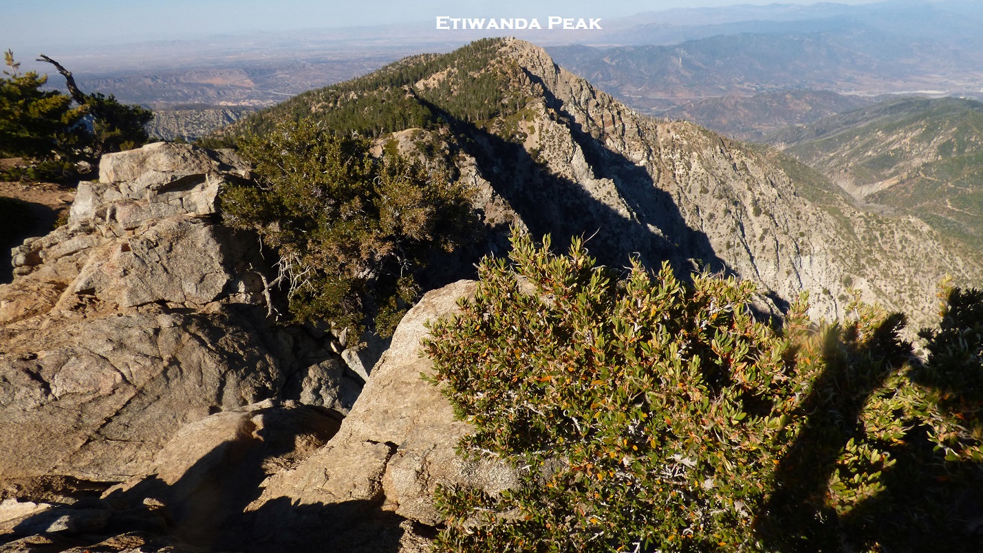
Although Etiwanda looked like nothing more than a little nibble of a peak from Cucamonga, it was a mile away and still contained over 300 ft of prominence. We took a well defined trail along the connecting ridge from Cucamonga. The trail wrapped around the west side of Etiwanda, where a use-trail marked with cairns branched off to its summit. Even through the fatigue, I couldn't help but appreciate the great views from this peak with its ornate twisted trees. We sat down briefly at the summit, signing a register placed in 2007, then reluctantly trudged back towards Cucamonga.
summit of Etiwanda


Gus with register

heading back down


Back at the saddle between Cucamonga and Bighorn, we took some deep breaths before starting the ascent of Bighorn's southeast ridge. Even though this ridge only gained a few hundred feet, it felt like over a thousand. There was no officially maintained trail heading up this ridge, but a use-trail flickered in and out. The sun set shortly before we reached the summit. We stood there briefly, staring out west towards the last peak: Ontario Peak.
southeast ridge of Bighorn

alpenglow on Cucamonga

summit view from Bighorn

A well defined trail headed west from Bighorn, following the connecting ridge to Ontario. A little less than a mile later, it joined up with the Ontario Peak Trail. A sign at this junction indicated that Ontario Peak was still 1.4 miles away. We sat around for a bit, forced down some food, and slowly trudged the remaining distance to Ontario, headlamps blazing. The trail was slightly overgrown and blocked by a few fallen trees in places, but was in general easy to follow. Several false summits later, we arrived at the rocky true summit. I set up my camera on a rock and took a 30 second exposure of the city lights below, realizing that it was overexposed. I was too tired to take another photo, thinking that I would be back on some future date, maybe even for a winter camp out. If hiked just by itself, Ontario was a very easy peak.
summit of Ontario


We groggily congratulated eachother on finishing the last peak, then began the slow march out. Back at the trail junction, we continued down the Ontario Peak Trail back to Icehouse Saddle. From there it would be 3.7 miles to Icehouse Trailhead (4,982 ft) where one of the cars was parked. Down we went, slowly and steadily. Every mile we would have to stop due to burning legs. After an eternity, the lights around the Icehouse Trailhead parking lot became visible. We finally arrived back just before 1am Monday morning. The entire traverse had taken just shy of 23 hours. It would be another hour of car shuttle along the horrible Glendora Mountain Rd before we would get back to Heaton Flat to pick up the other car and get any sleep along various parts of road on the way out.
Final Stats (Since Blogger does not let me upload this file at full size, email me at eric.jsc@gmail.com for a full sized version of this map)
36.5 miles
16,300/13,350 ft gain/loss

16,300/13,350 ft gain/loss

Weather Forecasts
East Fork Trailhead
3,600 ft
Iron Mountain
8,800 ft
Mt. Baldy
Peakbagger Pages
Iron Mountain
San Antonio Ridge Peak
West Baldy
Mt. Baldy
Mt. Harwood
Thunder Mountain
Telegraph Peak
Timber Mountain
Cucamonga Peak
Etiwanda Peak
Bighorn Peak
Ontario Peak
Summitpost Pages
Iron Mountain
West Baldy
Mt. Baldy
Mt. Harwood
Thunder Mountain
Telegraph Peak
Timber Mountain
Cucamonga Peak
Etiwanda Peak
Bighorn Peak
Ontario Peak
Other
Angeles National Forest
I've been on all of these peaks, it just took me 7 trips, haha! Well, all except the SAR so I guess it will be 8 trips.
ReplyDeleteThat was an insane ultra marathon. Props to you and Gus. Nice work!
Your shots coming back from Etiwanda are surreal. Looks very much like the background on the Blogger theme I use. Here is the blogger background. Eerie.
If you care to smash all known mortal records, a San Gabriel Death March was envisioned around 2009 as a loop that could start from multiple places. If started from Heaton Flat, it would go over Rattlesnake, then Hawkins Ridge, PCT to Baden-Powell, Blue ridge to Baldy North Backbone, San Antonio Ridge, Iron, back to Heaton Flat. I think someone estimated 45 miles. It has been attempted twice but no one has done it. Here is the discussion thread:
http://sangabrielmnts.myfreeforum.org/ftopic1173-0-asc-0.php
Thanks for the awesome posts.
Sounds as epic and insane an adventure as the Angeles Crest 100. You guys are like SuperheroHikers! But why didn't you bag Sugarloaf Peak on your way down from Ontario & Bighorn? ;-)
ReplyDeleteHella wicked! Good work, nice photos too!
ReplyDeleteawesome hike. can you share the gpx file?
ReplyDelete