
December 23, 2013
It was time for another conditioning hike in the San Gabriel Mountains. I met up with a group of five at the Mt. Baldy Visitor Center for the start of the hike. They had planned to first ascend Mt. Baldy via the Bear Canyon Trail, descend from Baldy to Baldy Notch via the Devil's Backbone Trail, take the Three Tee's Trail, climbing the 3 T's peaks (Thunder, Telegraph, Timber) along the way, then finally taking the Icehouse Canyon Trail down to the Icehouse Canyon Trailhead. The group decided to set up a car shuttle between the two trailheads. For those who are either soloing the route or cannot obtain a car shuttle, the distance between the trailheads is 1.5 miles and easily walkable.
I planned to deviate from the route at the beginning by climbing nearby Lookout Mountain via HPS Route 1 and then traversing northeast along a main ridge connecting Lookout Mountain, Peak 6930, and Mt. Baldy. The ridge intersects the Bear Canyon Trail just below 9,000 ft.
| Peak | Elevation | Topographic Prominence | Summit Coordinates (lat/lon) |
|---|---|---|---|
| Lookout Mountain | 6,812 ft | 152 ft | 34.248755, -117.675223 |
| Peak 6930 | 6,930 ft | 390 ft | 34.253380, -117.670376 |
| West Baldy | 9,988 ft | 128 ft | 34.286847, -117.654709 |
| Mt. Baldy* | 10,064 ft | 6,244 ft | 34.289129, -117.646304 |
| Mt. Harwood | 9,552 ft | 172 ft | 34.286498, -117.63317 |
| Thunder Mountain | 8,587 ft | 367 ft | 34.265267, -117.605848 |
| Telegraph Peak | 8,985 ft | 1,183 ft | 34.26161, -117.5985 |
| Timber Mountain | 8,303 ft | 563 ft | 34.245198, -117.593608 |
*The official USGS name for this peak is "Mt. San Antonio," but it has been so locally and widely referred to as "Mt. Baldy" that I will refer to it as such in this trip report.
Getting to the trailhead (start): I chose to start this route from the parking lot of the Mt. Baldy Visitor Center. It is also possible to start from Cow Canyon Saddle. From the visitor center, head 0.2 miles south down Mt. Baldy Rd. Turn right onto Glendora Ridge Rd and travel a mile to an open parking area. Based on other reports, there have been private property issues with the parking around Cow Canyon Saddle. There is public parking in a small dirt pullout on the other side of the street which is usually taken up quickly.
Getting to the trailhead (finish): From the Mt. Baldy Visitor Center, head north up Mt. Baldy Road. After 1.4 miles, turn right onto Icehouse Canyon Rd. A large parking lot (Icehouse Canyon Trailhead) should appear to the left.
I began hiking from the visitor center at around 6:40 am, finding myself at Cow Canyon Saddle (4,530 ft) at 7am just as the sun was rising. From Cow Canyon Saddle, a dirt road branched off towards the north. I followed the road for a quarter mile to the base of a ridge, then began ascending the ridge using a firebreak that was cut along the top of it. After about 200 ft on the ridge, a use trail branched off to the left. This trail was difficult to spot, and could only be seen if one knew it was there. Once on the trail itself, it was generally easy to follow. The trail contoured over to the northwestern side of the ridge, ascending to a saddle southeast of Lookout Mountain at 5,480 ft. From the saddle, the trail ascended steeply up Lookout's Southeast Ridge. About 0.6 miles after Saddle 5,480 ft, another use trail branched off to the left. A yucca plant marked the trail fork. I took the left branch, which looked to be a steeper and more direct path to the summit.
looking north from Cow Canyon Saddle

use trail branching off from firebreak (left photo) and trail fork on Lookout's Southeast Ridge (right photo)

views from Southeast Ridge


A class 3 rock formation seemed to block the trail not far below the summit. This rock could be bypassed to the right.

I reached Lookout's summit at 8:02 am am, finding a register hidden behind a rock containing a benchmark. Based on the amount of register entries, this peak is climbed at least once a week.


view east from summit

south

west

northeast

From Lookout Mountain's summit, the traverse to Peak 6930 and the Bear Canyon Trail looked pretty straightforward. Based on reports, there were supposed to be a series of use trails connecting Lookout Mountain and Peak 6930. I located one easily, and followed it to an area just below 6930's summit. Sensing that the trail was heading around the peak instead of to the summit, I left the trail and cross countryed the last few hundred feet up to 6930's summit.
views from traverse between Lookout and Peak 6930


The entire traverse between Lookout and Peak 6930 took no more than 15 minutes. I thought that 6930's summit contained much better views than that of Lookout's.
view west from 6930


southeast

northeast

The remaining distance between 6930 and the Bear Canyon Trail consisted of all cross country class 1-2 terrain. The routefinding was very simple: Follow the ridge northeast until it intersects a north-south running ridge containing the trail. There were numerous small trails here and there branching off in several directions. At first I thought they made by other people who had previously done the traverse, but then realized that they were sheep and deer trails. Some of them looked very tempting to follow, but I avoided them as they generally did not stay on or near the ridge. This part of the hike contained probably some of the most scenic terrain I had seen in the San Gabriels.
views from traverse


At 10:47 am, I intersected the Bear Canyon Trail. The trail was very well defined and not hard to spot.
views from Bear Canyon Trail


Shortly after intersecting the trail, I met up with everyone in the group except Dave, who was about an hour ahead and already standing on Baldy's summit. We crossed a treeless portion of the ridge at ~9,000 ft. Because this type of terrain is very rare in Southern California, this spot is one of the most photographed locations in the San Gabriel Mountains.


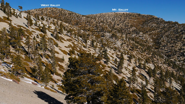
As the trail contoured around the south side of West Baldy, I left the trail and walked a few minutes over to West Baldy's summit. I usually would not consider something like West Baldy as a true peak, but numerous locals and regulars have treated it as one. The views from its summit are OK, and not all that different than the views from Baldy.
looking east from West Baldy

From West Baldy, it was an quick easy walk up to the summit of Mt. Baldy. I found Dave sitting at the summit, having been there for over an hour. I ate a quick snack as we chatted and waited for the remainder of the group to catch up.
view northwest from Baldy


After 45 minutes on the summit of Baldy, we headed east down the Devil's Backbone Trail. With this being the most popular route up Baldy, we passed numerous groups on the way down, including a large group of 25. Along the way, Dave and I tagged the summit of Mt. Harwood, a small peaklet not far off the trail.
looking towards Harwood from ~200 ft east of Baldy's summit


Earthscope Plate Boundary Observatory Station on Harwood

view southeast from Harwood's summit

views from Devil's Backbone Trail


As we neared Baldy Notch, the trail turned into a fire road, which we continued following southeast. 3.2 miles after leaving the summit of Baldy, we arrived at the lowpoint (7,830 ft) between Baldy and Thunder. Here, we found a sign which indicated that Thunder Mountain was 1.4 miles away. We followed a fire road up the remaining distance to Thunder.

view of Telegraph Peak from fire road

We arrived at the summit of Thunder at 1:54 pm. The summit was not too exciting, containing the top of a ski lift. The remaining two peaks would be much more interesting.

From Thunder, we followed the fire road for 0.1 miles down the west side of the mountain to the start of the Three Tee's Trail, which split off to the left.

The remainder of the hike was straight forward. We followed the Three Tee's Trail to Telegraph, Timber, and Ice House Saddle. The Three Tee's trail did not actually go to the summits of Telegraph and Timber, but there were separate trails that branched off to the individual summits as the Three Tee's trail came close to them.
Telegraph seen from Thunder

views between Timber and Telegraph


After postholing in snow for the last mile before Telegraph, we arrived at the summit at 2:52 pm. There was a register box at the summit that did not contain a lid, so all of its contents were pretty much sopping wet. As I signed in, the ink from the pen bled all over the paper.

view south from Telegraph summit

views between Telegraph and Timber


The turnoff for Timber Mountain was marked by a sign indicating a quarter mile to the summit.

A few feet behind the "Timber Mountain" sign at the summit was a register attached to a tree with "Chapman Mt" written on it. Based on local reports, Chapman Mountain was what Timber Mountain used to be called.

views from Timber Mountain


view of West Baldy, Baldy, and Telegraph

From Timber, we headed 0.9 miles down to Icehouse Saddle, then took the Icehouse Canyon Trail 3.7 miles down to Icehouse Canyon Trailhead, arriving sometime around 5:30 pm.
sign at Icehouse Saddle

sunset on the slopes of Mt. Baldy seen from Icehouse Canyon

Final Stats
20.2 miles
9,900 ft gain/loss

Weather Forecasts
Trailhead, Lookout, 6930
West Baldy, Mt. Baldy, Harwood (Mt. Baldy has an elevation of 10,064 ft. Keep in mind that this forecast is for 8,840 ft)
Thunder, Telegraph, Timber
Peakbagger Pages
Lookout Mountain
Peak 6930
West Baldy
Mt. Baldy
Mt. Harwood
Thunder Mountain
Telegraph Peak
Timber Mountain
Summitpost Pages
Lookout Mountain
West Baldy
Mt. Baldy
Mt. Harwood
Thunder Mountain
Telegraph Peak
Timber Mountain
Other
Angeles National Forest
San Gabriel Mountains Discussion Forum
Starting trailhead coordinates (lat/lon): 34.238567, -117.657367
Finishing trailhead coordinates (lat/lon): 34.250202, -117.636043
I began hiking from the visitor center at around 6:40 am, finding myself at Cow Canyon Saddle (4,530 ft) at 7am just as the sun was rising. From Cow Canyon Saddle, a dirt road branched off towards the north. I followed the road for a quarter mile to the base of a ridge, then began ascending the ridge using a firebreak that was cut along the top of it. After about 200 ft on the ridge, a use trail branched off to the left. This trail was difficult to spot, and could only be seen if one knew it was there. Once on the trail itself, it was generally easy to follow. The trail contoured over to the northwestern side of the ridge, ascending to a saddle southeast of Lookout Mountain at 5,480 ft. From the saddle, the trail ascended steeply up Lookout's Southeast Ridge. About 0.6 miles after Saddle 5,480 ft, another use trail branched off to the left. A yucca plant marked the trail fork. I took the left branch, which looked to be a steeper and more direct path to the summit.
looking north from Cow Canyon Saddle

use trail branching off from firebreak (left photo) and trail fork on Lookout's Southeast Ridge (right photo)

views from Southeast Ridge


A class 3 rock formation seemed to block the trail not far below the summit. This rock could be bypassed to the right.

I reached Lookout's summit at 8:02 am am, finding a register hidden behind a rock containing a benchmark. Based on the amount of register entries, this peak is climbed at least once a week.


view east from summit

south

west

northeast

From Lookout Mountain's summit, the traverse to Peak 6930 and the Bear Canyon Trail looked pretty straightforward. Based on reports, there were supposed to be a series of use trails connecting Lookout Mountain and Peak 6930. I located one easily, and followed it to an area just below 6930's summit. Sensing that the trail was heading around the peak instead of to the summit, I left the trail and cross countryed the last few hundred feet up to 6930's summit.
views from traverse between Lookout and Peak 6930


The entire traverse between Lookout and Peak 6930 took no more than 15 minutes. I thought that 6930's summit contained much better views than that of Lookout's.
view west from 6930


southeast

northeast

The remaining distance between 6930 and the Bear Canyon Trail consisted of all cross country class 1-2 terrain. The routefinding was very simple: Follow the ridge northeast until it intersects a north-south running ridge containing the trail. There were numerous small trails here and there branching off in several directions. At first I thought they made by other people who had previously done the traverse, but then realized that they were sheep and deer trails. Some of them looked very tempting to follow, but I avoided them as they generally did not stay on or near the ridge. This part of the hike contained probably some of the most scenic terrain I had seen in the San Gabriels.
views from traverse


At 10:47 am, I intersected the Bear Canyon Trail. The trail was very well defined and not hard to spot.
views from Bear Canyon Trail


Shortly after intersecting the trail, I met up with everyone in the group except Dave, who was about an hour ahead and already standing on Baldy's summit. We crossed a treeless portion of the ridge at ~9,000 ft. Because this type of terrain is very rare in Southern California, this spot is one of the most photographed locations in the San Gabriel Mountains.


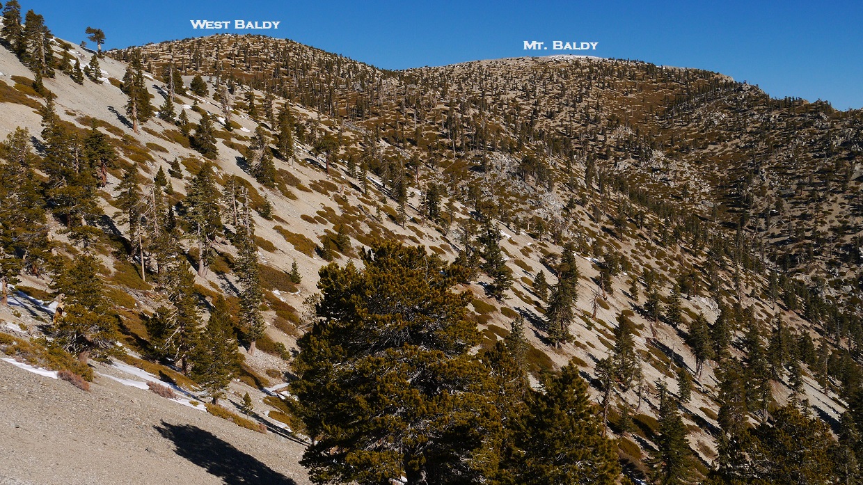
As the trail contoured around the south side of West Baldy, I left the trail and walked a few minutes over to West Baldy's summit. I usually would not consider something like West Baldy as a true peak, but numerous locals and regulars have treated it as one. The views from its summit are OK, and not all that different than the views from Baldy.
looking east from West Baldy

From West Baldy, it was an quick easy walk up to the summit of Mt. Baldy. I found Dave sitting at the summit, having been there for over an hour. I ate a quick snack as we chatted and waited for the remainder of the group to catch up.
view northwest from Baldy


After 45 minutes on the summit of Baldy, we headed east down the Devil's Backbone Trail. With this being the most popular route up Baldy, we passed numerous groups on the way down, including a large group of 25. Along the way, Dave and I tagged the summit of Mt. Harwood, a small peaklet not far off the trail.
looking towards Harwood from ~200 ft east of Baldy's summit


Earthscope Plate Boundary Observatory Station on Harwood

view southeast from Harwood's summit

views from Devil's Backbone Trail


As we neared Baldy Notch, the trail turned into a fire road, which we continued following southeast. 3.2 miles after leaving the summit of Baldy, we arrived at the lowpoint (7,830 ft) between Baldy and Thunder. Here, we found a sign which indicated that Thunder Mountain was 1.4 miles away. We followed a fire road up the remaining distance to Thunder.

view of Telegraph Peak from fire road

We arrived at the summit of Thunder at 1:54 pm. The summit was not too exciting, containing the top of a ski lift. The remaining two peaks would be much more interesting.

From Thunder, we followed the fire road for 0.1 miles down the west side of the mountain to the start of the Three Tee's Trail, which split off to the left.

The remainder of the hike was straight forward. We followed the Three Tee's Trail to Telegraph, Timber, and Ice House Saddle. The Three Tee's trail did not actually go to the summits of Telegraph and Timber, but there were separate trails that branched off to the individual summits as the Three Tee's trail came close to them.
Telegraph seen from Thunder

views between Timber and Telegraph


After postholing in snow for the last mile before Telegraph, we arrived at the summit at 2:52 pm. There was a register box at the summit that did not contain a lid, so all of its contents were pretty much sopping wet. As I signed in, the ink from the pen bled all over the paper.

view south from Telegraph summit

views between Telegraph and Timber


The turnoff for Timber Mountain was marked by a sign indicating a quarter mile to the summit.

A few feet behind the "Timber Mountain" sign at the summit was a register attached to a tree with "Chapman Mt" written on it. Based on local reports, Chapman Mountain was what Timber Mountain used to be called.

views from Timber Mountain


view of West Baldy, Baldy, and Telegraph

From Timber, we headed 0.9 miles down to Icehouse Saddle, then took the Icehouse Canyon Trail 3.7 miles down to Icehouse Canyon Trailhead, arriving sometime around 5:30 pm.
sign at Icehouse Saddle

sunset on the slopes of Mt. Baldy seen from Icehouse Canyon

Final Stats
20.2 miles
9,900 ft gain/loss

Weather Forecasts
Trailhead, Lookout, 6930
West Baldy, Mt. Baldy, Harwood (Mt. Baldy has an elevation of 10,064 ft. Keep in mind that this forecast is for 8,840 ft)
Thunder, Telegraph, Timber
Peakbagger Pages
Lookout Mountain
Peak 6930
West Baldy
Mt. Baldy
Mt. Harwood
Thunder Mountain
Telegraph Peak
Timber Mountain
Summitpost Pages
Lookout Mountain
West Baldy
Mt. Baldy
Mt. Harwood
Thunder Mountain
Telegraph Peak
Timber Mountain
Other
Angeles National Forest
San Gabriel Mountains Discussion Forum
No comments:
Post a Comment