
August 17, 2013
Day 2 of the Sierra Challenge consisted of climbing two thirteeners near the Rock Creek area. These peaks- Twelve Flags Peak (13,470 ft) and Adamson Point (13,200 ft), both needed to be climbed in order for them to count as a full Challenge peak. Both peaks were supposedly easy, likely due to the upcoming sufferfest planned for the next day.
Getting to the trailhead
Trailhead coordinates (lat/lon): 37.451693, -118.734389
This day turned out to be very popular as it was a Saturday and there were a plethora of peaks in the Rock Creek area. I had a feeling that most people had Mt. Morgan (13,748 ft) on their minds, as it is the highest peak in that area. I had already climbed Morgan before but decided to head to it anyway since it was very close to Twelve Flags and I could bag an extra peak. After Morgan, I planned to traverse a short ways northeast to Twelve Flags Peak. A supposedly class 3 ridge branched off from Twelve Flags heading southeast towards Adamson. This ridge would be traversed heading right by Broken Finger Peak (13,080 ft) along the way. Many of us saw Broken Finger Peak as an easy bonus peak that would be handed right to us.
Day 2 start (photo by Bob Burd)

We left Tamarack Trailhead at 6:04 am and began hiking up the trail heading towards Dorothy Lake. After 1.9 miles, we branched off right towards Francis Lake 0.8 miles away.

Francis Lake (10,900 ft), last water source before Tamarack Lakes

Above Francis Lake, a wide canyon headed southwest towards Morgan. The terrain was initially grassy and relatively flat, but soon turned into rock hopping. A large "hump" of talus appeared, blocking off the remaining canyon from view. We continued up the canyon, climbing up and over this hump.
talus hump Southwest of Francis Lake

From the top of this hump, the remaining route to Morgan was very obvious. I continued a little ways further up the canyon, then took a spur ridge extending outward from Morgan's sub-summit plateau. This ridge contained class 2 climbing on solid rock.

Once on the plateau, I made a beeline for Morgan's obvious summit.

I reached Morgan's summit (13,748 ft) at 8:20 am and and was joined shortly after by Sean. We searched around for a register, but found none- not surprising considering the popularity of this peak. Pat and Craig made their way up to the summit, and we sat around for a few moments munching on snacks and enjoying Morgan's amazingly panoramic views.

north

northwest

southwest

south-southwest

zoom into Merriam, Royce, & Feather peaks

northeast

We scanned the ridge between Twelve Flags and Adamson Point, which certainly did not look like class 3, but more like low class 5. Composed of a series of ribs, notches, and chutes, the traverse between Twelve Flags and Broken Finger looked to be the toughest. After Broken Finger, the ridge seemed to flatten out ever so slightly. As Sean and I left the summit of Morgan, we heard someone say "Wow, heck of a traverse you got there. Well good luck."
The hike between Morgan and Twelve Flags was easy class 1-2 with straightforward routefinding.

We reached the summit of Twelve Flags (13,470 ft) at 9:02 am to find Bob, Jonathan, and Luca examining the traverse that lay ahead of them. Twelve Flags did not contain a summit register, so Jonathan brought one out that he had prepared earlier, and planted it on the summit.
view northeast from Twelve Flags summit

south

northwest towards Morgan

Bob contemplating the traverse to Adamson

Before Sean and I had signed the register, Jonathan had already began the traverse, seeming very eager to get started.

Sean and I started off across the ridge at 9:10 am, our eyes set on Broken Finger Peak. After we left Twelve Flags summit, the terrain immediately turned to class 4. The rock was solid for the most part, but we would still occasionally knock down boulders the size of watermelons. As we dropped further below Twelve Flags, a mix of class 4 terrain with a few low class 5 sections provided some excellent climbing. Both of us enjoyed it immensely. Somewhere along the line, we noticed Jonathan bailing off into a considerably loose scree chute to the east side of the ridge. He was also planning on climbing Broken Finger Peak, and probably thought that descending and reascending the ridge later would be faster than traversing it all the way. Sean and I could hear a steady sound of rockfall following him down the chute. We continued along the ridge, enjoying it more and more as it went on, working our way through a series of ribs containing cliff-outs and short knife-edges.


As the solid white granite began coming to an end, we shook our heads at the black metamorphic rock that lay ahead. All of Broken Finger Peak was composed of this rock, which was almost certain to be some degree of loose and crumbly.

our route up Broken Finger

lowpoint on ridge between Twelve Flags and Broken Finger

Upon reaching the base of Broken Finger, it was pretty clear that we would not be able to access the peak by staying on the main ridge. A series of chutes that shot up Broken Finger's southwest side looked to be the easiest approach. At this point, we heard heavy breathing below us, and turned to see Jonathan powering up a scree chute from the east to meet us on the ridge below Broken Finger. He uttered a quick "hi" and quickly proceeded to the southwest chutes. Sean and I proceeded up the first chute we saw, and Jonathan went right past it to the second one. It seemed like he knew something that we didn't. After a few moments, our chute ended in a cliff-out, and we were forced to traverse over to Jonathan's chute.
Jonathan climbing up second chute

second chute closeup

We proceeded up the chute towards Jonathan, knocking down several hunks of shale which clinked like broken dinner plates as they fell. The climbing was strong class 3 at most, and we reached the summit (13,080 ft) in seemingly no time at all. An old register was found on the summit, placed by Andy Smatko on his first ascent. It was interesting to find out that the peak was named after an actual broken finger that was attained on that first ascent.
view northwest from Broken Finger summit

west towards Morgan

southwest

northeast

traverse to Adamson (southeast)

From the summit of Broken Finger, the ridge to Adamson looked like a leisurely stroll compared to the one we had just traversed. After we had descended to a bump southeast of Broken Finger, that theory had been proven wrong. A series of loose-looking ribs and gendarmes lay between us and the saddle between Broken Finger and Adamson. A whole lot of tedious climbing lay ahead. Jonathan, convinced that he could bypass the crappy terrain by heading lower west, soon found himself standing on top of a cliff-out, which he managed to downclimb via class 3-4 rock.


interesting gendarmes

Sean and I continued forward, staying on the western side of the ridge. The terrain was horribly loose, and we were causing rockslides left and right. Though it was probably possible to traverse this area with all class 3 climbing, we climbed onto several areas of class 4 rock which was somewhat more solid and safe than class 3 on potato chips. Pretty soon we came to a prominent notch (12,800 ft) on the main ridge, which we would later return to after Adamson, using it go get down to Tamarack Lakes.
loose ribs, chutes, and fins galore!


Notch 12,800 ft

After the notch, we were able to climb back onto the main ridge where most of our troubles were over. The remaining distance to Adamson spread out before us. We traversed the ridge up to a point where a big gap ran through it. This gap turned out to be part of an old mine. Once in the gap, we walked over to the other side where some old mining equipment was scattered around. An old mining road zigzaged up Adamson's southwest side.
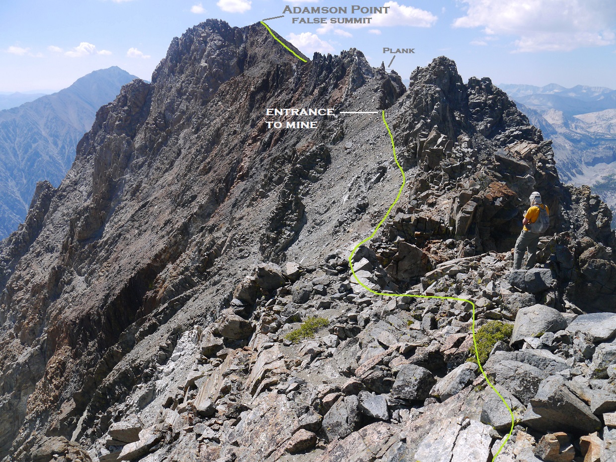
walking through the gap

mining equipment
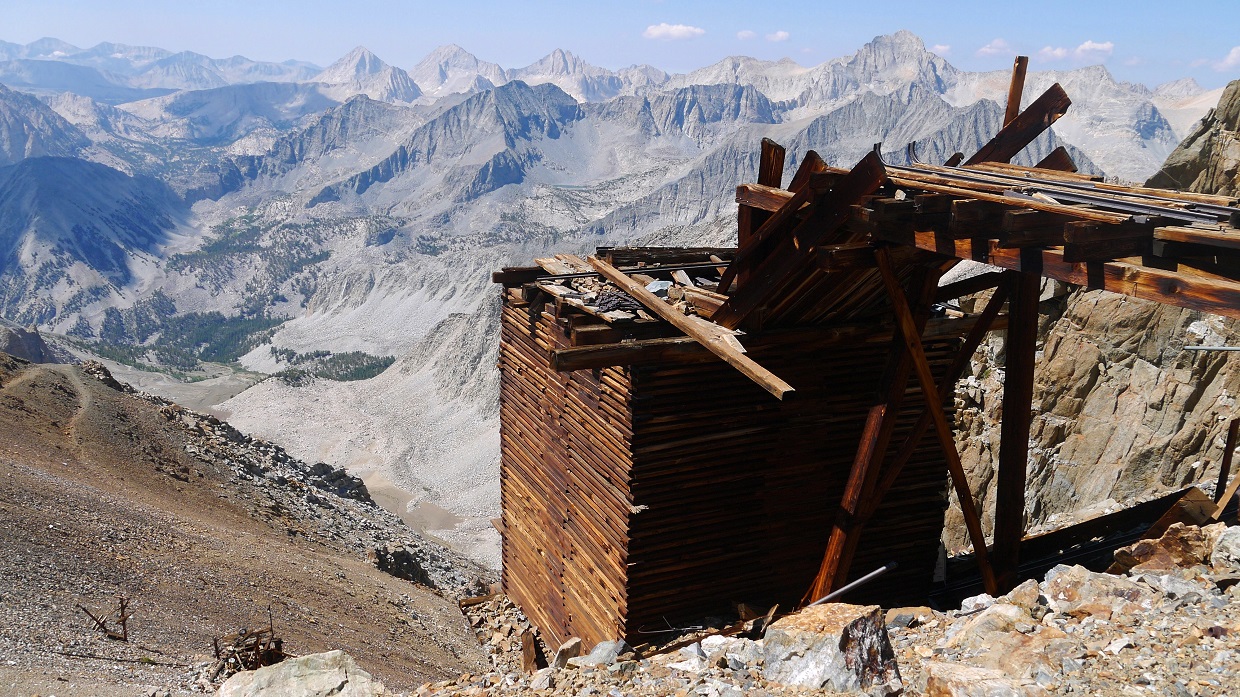

old road

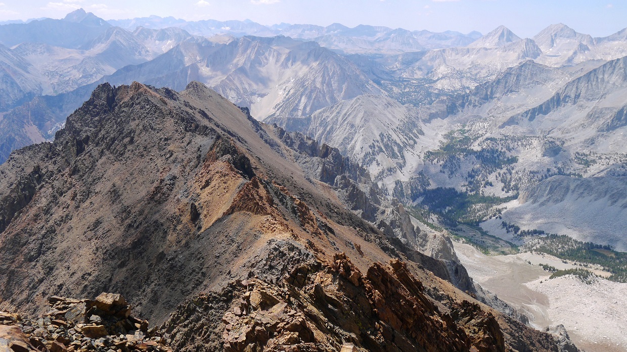
We made our way back onto the main ridge and followed it towards Adamson. What looked like the top at first turned out to be a false summit.

true summit viewed from false summit

After a few fun class 3 moves, we found ourselves on the summit at 11:20 am. The views from this peak were by far the best I had seen from any peak that day.
Sean signing register

view southeast towards Mt. Tom

east towards Pine Creek

northeast

southwest

south
Jonathan making his way to the summit


more views


Luke

Just as Luke was traversing over to the summit, Pat came around a corner and scampered up as fast as she could to pass him, seemingly determined to be the first one of them to summit.

Pat and Luke had taken a look at the ridge from Twelve Flags, decided it was too dangerous, and descended a chute to the south. Upon reaching a canyon, they continued south, picking up the old mining road and following it to Adamson.
The four of us remained on the summit for some time debating on descent plans. At the end, Jonathan decided to descend the mining road, pick up a trail to Morgan Pass, and end up at Mosquito Flat where he would either walk or hitchhike back to Tamarack Trailhead. The rest of us decided to descend to Tamarack Lakes and pick up the Tamarack Lake Trail which would get us back to Tamarack Trailhead.
Jonathan boot-skiing to the mining road

Sean and I traversed back along the ridge to Notch 12,800 ft with Pat and Luke following. A spur ridge connecting to Wheeler peak branched off to the east of Notch 12,800ft. We followed this ridge a few hundred feet east, then located a scree chute dropping down the north side of it. This chute was incredibly loose so we descended it one at a time, with each person shouting "CLEAR!" to the people above them once they had descended to a point safe from rockfall.

After the chute, it was a straightforward walk to Tamarack Lakes. We refilled on water at the inlet of the largest lake.

looking back up the chute

refilling water

From Tamarack Lakes, we headed north to meet the Tamarack Lakes Trail. This trail was well defined and padded down, making for some easy downhill jogging. Pat and Luke were nowhere in sight, but they were not far behind us. A few booms of thunder sounded, but they did not really concern us since we were already off the mountains.


Wheeler Peak

increasing clouds

back at Tamarack Trailhead, 2:11 pm

Final Stats
14.3 miles
6,530 ft gain/loss

Weather Forecasts
Trailhead
all peaks (All the peaks have elevations over 13,000 ft. Keep in mind that this forecast is for 12,428 ft)
Peakbagger Pages
Mt. Morgan
Twelve Flags Peak
Broken Finger Peak
Adamson Point
Summitpost Pages
Mt. Morgan
Twelve Flags Peak
Broken Finger Peak
Other
Bob Burd trip report
Sean O'Rourke trip report
High Sierra Topix message board
Inyo National Forest
No comments:
Post a Comment