
June 14, 2025
The Sierra Blanca is a sub-range of the greater Sangre de Cristo range in southern Colorado. While most of the Sierra Blanca consists of low brushy hills and gentle valleys, there's one section of it which juts up in a rapid rise of elevation. This section contains a north-facing basin which contains the headwaters of the Huerfano River, along with Blanca Peak, Colorado's 4th highest peak.
Looking at a topo map, the circular structure of this Huerfano Basin, along with the dramatic peaks which surrounded it, just screamed out at me as an aesthetic traverse. A quick mapping of this traverse indicated that it would summit twelve peaks, including three 14ers. Some online research indicated that two of the connecting ridges on this traverse would involve class 5 climbing, namely Gash Ridge (the east ridge) of Blanca Peak, and the north ridge of Ellingwood Point. Although I was able to research several sections of the overall route that had been done before, I was not able to locate a complete linking ascent, although it is unlikely that I was the first to complete it, just based on how obvious it looked on a map.
This would be my first time in the Sangre de Cristos, so the unfamiliarity of the area meant that I would not be moving super efficiently, and would need an entire day to complete the objective. To have an entire day without thunderstorms in Colorado in the summer was a difficult ask, but it wasn't even a couple months later in mid June 2025 that the day came, along with good snow conditions, meaning just a little snow on the ground- just enough to stuff into water bottles here and there but not enough to cause frequent postholing. The previous winter of 2024/5 had been a dry one, with the Sangre de Cristos receiving under 75% of its regular snowfall.
Final Stats
19 miles
10,500 ft gain/loss
------------------
Colorful displays of lightning lit up the eastern sky as I made the 4 hour drive to the Huerfano Basin after work on Friday. The forecast had called for clear skies the following day, and I hoped that would hold as I watched the clouds lightning up every couple seconds. The last 12 miles of road before the trailhead was dirt, with only the last few miles after passing Singing River Ranch requiring any higher clearance vehicle. I put the jeep in 4WD for this part which probably wasn't necessary, but nice to have. I arrived at the trailhead (37.63993, -105.47076) at 12:40am. It was a beautiful primitive campsite along the Huerfano River, with multiple makeshift fire rings and flat areas for tents, sheltered by trees. Surprisingly no one was here, despite all the other spots before this being taken up by campers. I didn't really get a chance to enjoy it though, with my planned early start.
4:30am found me groggily grabbing my backpack and walking a few hundred feet south up the road to pick up the Raspberry Trail, which crossed the Huerfano River and headed east, gaining roughly 1,000 ft of elevation in a mile. The entrance of this trail was not clearly marked, but relatively easy to find in the dark. Crossing the river involved a short slippery walk across a wet log that was just above waterline. I was just happy to not have to take my shoes off for it. The mile of ascending trail went quick, and before long I made a 90 degree turn to the south to leave the trail as it crossed a small saddle just south of spot elevation 11085 on the topo. The cross country terrain was easy and monotonous, gradually ascending through the forest until the trees abruptly ended at 11,700 ft. I would not see anymore trees from this point on until near the end of the day. The remainder of the gradually ascending north "ridge" (if you can even call it that) of Huerfana Peak consisted of gently rolling tundra and not much rock hopping. I reached the summit of Huerfana and had my first snack of the day, gazing out at almost the entire traverse that was visible from there.


After Huerfana, the nice soft tundra was instantly replaced by loose scree, and I remained slightly on the right (west) side of the ridge before ascending and descending a smaller bump immediately south of Huerfana. There were a few easy class 3 sections here, but it was mostly class 2 loose. Back on the ridge at the bump, I remained on it for the remainder to Huerfano Peak, doing some unnecessary but fun class 3 in the process, lest I wanted to drop lower onto some crappy scree. The ridge was surprisingly fun, and I was all smiles as I cruised over to the summit of Huerfano Peak. From there, the tiny Iron Nipple and large plump mass of Mt. Lindsey revealed themselves to the south.


The ridge between Huerfano and Iron Nipple started off with light rock hopping, then cruiser tundra. The last few hundred feet of the nipple involved easy class 2 scrambling. I was not sure why this was a named peak. Maybe it looked like a nipple from somewhere in the Huerfano Basin. From the nipple, I turned my attention south, aiming for a gap between the Iron Titties, two clumps of rock which formed a easy passage that was about 30 ft wide. After that some easy walking brought me to Lindsey Saddle and the throngs of people hiking up Mt. Lindsey, which was a popular 14er.
Last bit below Iron Nipple

Heading south towards Lindsey

I dropped my pack at Lindsey Saddle, praying that the marmot gods would be merciful, and made the quick scramble up Lindsey's northwest ridge. Despite this route getting climbed thousands of times a year, I was surprised at the bits of loose rock that people kept knocking off it, and I was glad to be on top of the ridge as the projectiles rained down on both sides. From Lindsey Saddle, I followed a use-trail to a short obvious headwall, where I briefly left the ridge to the left with a few class 3 moves before skirting back right onto the ridge proper, doing this quickly before the people above me would knock any more rocks down. Above the headwall, the ridge ascended gradually as the use-trail reappeared and led me to the summit. I remained on the summit for a few minutes before reversing the northwest ridge, finding several marmots gnawing at my pack left at Lindsey Saddle. After shooing them away, I found that they weren't even close to actually getting into the pack. The marmot gods had just been teasing today

Views from Lindsey (correction: N. Zapata & S. Zapata are reverse labeled here)


I walked down the Lindsey Trail for just under a quarter mile before the trail veered northwest down into Huerfano Basin and I continued southwest along the connecting ridge to Huerfanito and the low saddle between Lindsey and Huerfanito. From the low saddle, I could see that Huerfanito's east ridge was composed of death choss. It was circumventable to the left (south), ascending gradually through junk scree before veering north to the summit. The short 0.3 mi section between the low saddle and summit for this option would involve briefly crossing into private property. I imagine that if someone were uncomfortable crossing this short stretch of barren land, it was possible to go around the north side of Huerfanito before veering south to the summit, adding approximately another quarter mile and 200 ft of elevation gain compared to the other option on a worse looking screefield.
Huerfanito scree field

Huerfanito summit view

From the summit of Huerfanito, Gash Ridge could be seen in all its splendor, leading all the way to the tippy top of Blanca Peak, the highest point on the traverse. The ridge between Huerfanito and Blanca started off easy, but suddenly became broken up by a series of small towers shortly before the lowpoint between the peaks. I bypassed these by first dropping slightly south off the ridge for a hundred feet before crossing back over the ridge and dropping north, then contouring on scree below the towers, arriving at the actual lowpoint without much difficulty. From there, the ridge on the other side immediately rose steeply, and several class 4 and possibly low 5th moves were required for the next several hundred feet. I passed by the remnants of several slings that people had used for rappelling. After this section, the ridge mellowed out, ascending a talus ramp for about 500 ft of elevation. This ramp abruptly ended at a bump at 13,300 ft before the ridge narrowed again, turning into class 3. This part of the ridge was very aesthetic and mega fun, and I rode the top of it up and down as it gradually undulated to The Gash at 13,800 ft. The Gash was a small notch that would require a short class 4 downclimb to get to. It's one of those places that is extremely obvious once you're there. I first descended about 40 ft to the left of a small tower to a nest of slings, and carefully downclimbed about 20 ft of class 4 to the notch. The rock was good and there were plenty of holds. After The Gash, the ridge steepened. I again remained on the very crest of the ridge, doing mostly class 4 and a few short low 5th moves on good rock. There were a few slabby sections here which involved careful placement of the feet. I briefly contemplated taking the rock shoes out of the pack and putting them on, but it never got to that point.
lowpoint between Huerfanito and Blanca


Descent into The Gash


crux of Gash Ridge

The amazing thing about Gash Ridge is that it spits you out basically right on the summit- zero faffing with talus and scree after the good part ends. This was truly an aesthetic classic line, and I was surprised that not more people did it. I reached the summit of Blanca around 1pm and took a longer break there. A group of three were present, having scrambled up the standard route from Como Lake, and I had a chat with them as we ate snacks. It was a pleasant 55 degrees with no wind. A few small storm cells were popping up the the north, but they didn't look threatening to the immediate area.
Blanca summit views


After my pleasant break, I proceeded down Blanca's class 2 northwest ridge, finding significantly more snow accumulation here. I danced around it on rocks, occasionally having to cross through it and posthole up to my knees. From the saddle between Blanca and Ellingwood, the ridge became serrated with small towers. I bypassed these to the left (west), staying mostly on a use-trail (this Blanca-Ellingwood connector is a popular route for those hiking 14ers). A final short talus field brought me to the summit of Ellingwood, where I was surprised to see no one.

looking back at Blanca from Ellingwood

view north

eastern Huerfano Basin


Descending the north ridge of Ellingwood would be the last remaining technical obstacle of the day. Online reports indicated it being anything from class 4 to 5.4. From Ellingwood, I descended a short section of crappy rock, then down a talus ridge to an elevation of 13,600 ft. From here, the north ridge continued north while a separate, more mellow-looking ridge branched off to the west. There was a small cairn marking this intersection, as the exact spot to drop off to continue along the north ridge was not obvious. After descending roughly 50 ft from this spot, I could see a short class 3/4 chimney heading to the right. I proceeded down it, then veered back onto the ridge and continued descending light class 3 terrain for another hundred or so feet. As the ridge made a slight curve in a more easterly direction, it steepened. There were multiple options, but I found all of them to involve exposed class 4/low 5th downclimbing on rock that wasn't as good as that of Gash Ridge. Again, I contemplated taking out the rock shoes, but didn't end up doing it. There were still plenty of good holds, although a few of them moved. This steeper section lasted several hundred feet until I was near the lowpoint between Ellingwood and South Zapata Peak, where the ridge because less steep and turned to class 3.
looking north from 13,600 ft

looking towards South Zapata from 13,200 ft

looking back

Shortly before the actual lowpoint, the ridge became serrated, forcing me off the crest and to the left (west), where I followed a series of grassy ramps around the little towers. These ramps started off easy, but gradually cut through steeper terrain as the towers became more dramatic. Eventually I was scrambling sideways on class 3-4 terrain. The towers abruptly ended not far below spot elevation 13618, and it was cruiser back along the ridge crest to the summit of South Zapata, where there were excellent views of the ridge I had just descended off Ellingwood.
going around towers

view from spot elevation 13618

looking back


From South Zapata, I could see two prominent storm cell clusters to the north. One was to the northeast over Colorado Springs, and it showed multiple strong convective columns. The other was to the northwest, and it was very stratiform and composed of mostly high clouds. There was some rain falling under it as virga, with little to none of it looking to reach the ground. As I traversed the class 2 ridge to North Zapata, it became clear that the northwestern cluster was moving towards me. Knowing that stratiform clouds without a strong connective column are significantly less likely to produce lightning, I kept watching the system for any signs of convection as it crept closer. The virga eventually reached the desert floor below as the atmosphere below the cloud saturated. A brilliant cloudburst hit the desert floor approximately 20 miles away.

North Zapata Peak and Lost Peak were not extremely memorable, but easy. Great views abound. I remained on the ridge the entire time on class 2 terrain. The storm caught up as I ascended the south ridge of California Peak, which was nothing more than a giant talus heap. Now that the cloud was directly over me, I had to keep refreshing satellite imagery on my phone to watch for signs of convection. Thankfully, nothing concerning ever appeared. A light snow mixed with graupel fell, collecting on my clothes and the ground. The rocks were more slippery now, and I slowed my pace to adjust for more precise footing.

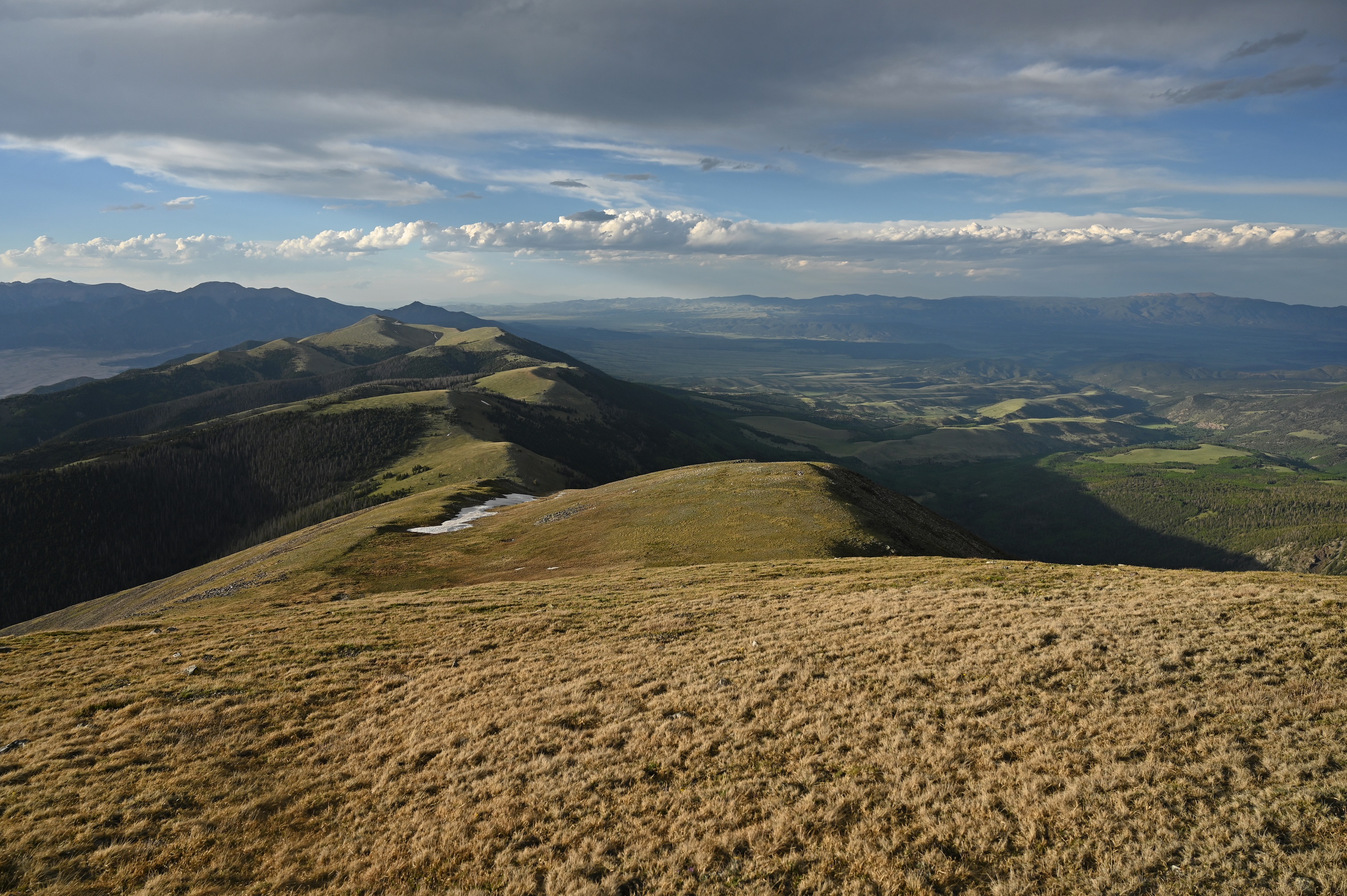
Once on the summit of California peak, the storm finally moved east. I could see the remainder of the traverse from here, composed of gentle rolling alpine tundra that gradually descended north over several miles. I would lose 2,000 ft of net elevation along this stretch between California Peak and the low saddle before Must-Do Peak. This stretch was fast and pleasant as my feet sank into the soft grass.
view north from California Peak

descending California Peak


From the saddle, it was a quick jaunt up to the summit of Must-Do Peak. From here there was a magnificent view of the Huerfano Cirque. I retraced my way to the saddle as the sun lit up the ridges around me in a brilliant orange glow.
looking towards Great Sand Dunes from Most-Do-Peak


It was roughly 2 miles from the saddle back to the trailhead. This went quickly, as it was all on trails (the western side of the Raspberry Trail). The trail was mostly easy to follow, except for a short overgrown section that went through a meadow where I startled several elk and deer. At 8pm, I was back at the trailhead, jubilant at having completed an insanely high quality and memorable route.
No comments:
Post a Comment