
July 28, August 4, 2018
The south side of Dusy Basin in the High Sierra is bordered by a picturesque ridge running from Thunderbolt Pass to Giraud Peak. The ridge often noted by photographers visiting Dusy Basin and backpackers traveling between Bishop Pass and the JMT. Isosceles Peak, which lays on the east side this ridge, is one of the most photographed peaks in the sierra. In addition to it's scenic nature, this ridge also looked to be a fun traverse, although there was no information I could glean about it from friends or the internet.
In the summer of 2018, I decided it would be a good time to tackle this ridge. Due to the plethora of available photos, I was able to at least study the ridge in detail from afar. Large sections of it looked technical, so I decided it was a good idea to bring a rope and rack. I was able to get four friends to join on the last weekend of July. Our plan was to hike over Bishop Pass early Saturday morning and set up camp at the first lake we came across in Dusy Basin, and complete the ridge from Thunderbolt Pass to Knapsack Pass on Saturday before hiking back to camp. On Sunday, we would get up bright and early, hiking back over to Knapsack Pass and traversing out the remaining ridge to an unnamed peak west of Giraud Peak.

| Peak | Elevation | Topographic Prominence | Summit Coordinates (lat/lon) |
|---|---|---|---|
| "T-Bolt Pass Peak" | 12,548 ft | 165 ft | 37.0944, -118.5269 |
| Isosceles Peak | 12,321 ft | 181 ft | 37.0936, -118.5385 |
| Columbine Peak | 12,662 ft | 562 ft | 37.0893, -118.5416 |
| "Knapsack Tower" | 12,144 ft | 125 ft | 37.0815, -118.5448 |
| "Stare Peak" | 12,267 ft | 165 ft | 37.0774, -118.5489 |
| "Face Peak" | 12,369 ft | 349 ft | 37.0767, -118.5505 |
| "Connector Peak" | 12,265 ft | 215 ft | 37.0799, -118.5582 |
| Giraud Peak | 12,608 ft | 908 ft | 37.0774, -118.5644 |
| "Roll Peak" | 12,182 ft | 214 ft | 37.0809, -118.5736 |
Getting to the trailhead: From Bishop off Hwy 395, head west on West Line Street (Hwy 168). Continue 15 mi, then turn left onto South Lake Rd, which will be clearly marked with a "South Lake" sign. Continue 7 mi to the end of this road.
Trailhead coordinates (lat/lon): 37.169338, -118.565850
Recommended gear: 60m rope (possibly two ropes to make rappels off Isosceles faster), single set of cams to 2", small to medium nuts
Total Stats
23.3 miles 9,020 ft gain/loss
Maps
23.3 miles 9,020 ft gain/loss
Maps
Approach


traverse detail

Trip Report
Donatas, Mason, Michael, Sean, and I left South Lake Trailhead just before sunrise, laden with heavy packs full of climbing gear. The hike up and over Bishop Pass was scenic as always, but nothing unexpected beyond the ordinary (this was maybe my 20th time hiking over Bishop Pass). Once over the pass, we hiked just over a mile before leaving the trail to set up camp at a large lake (11,345 ft).
views from camp


It took about 30 minutes to set up the tents and organize everything before we set off southeast towards Thunderbolt Pass. We first hiked up and over a broad ridge south of camp, then headed east to walk south along a land bridge between two very large lakes. Once on the south side of the larger eastern lake, we headed east, aiming directly for Thunderbolt Pass which was in clear view. The terrain became more bouldery here as we entered an old glacial moraine, but the boulders were surprisingly solid for the most part.

By noon, we had hit the northeast ridge of Thunderbolt Pass Peak which was mainly boulders with one short and exposed class 3 traverse out onto a face to the right. The summit contained a cool old register.


As the ridge progressed west, it was easy travel (class 1-2), until it began curving right. Here the ridge turned class 3 with a drop-off ahead. At the drop-off, we set up a 30 ft rappel. There were plenty of bomber flakes to sling here.


After rappelling, the ridge grew easy again for a short bit before Isosceles Peak. We hiked up Isosceles' southeast ridge for a few minutes before reaching some exposed class 4 moves. At this point, Donatas decided to skip this peak and head off to Columbine, the next peak.
looking back towards the rappel

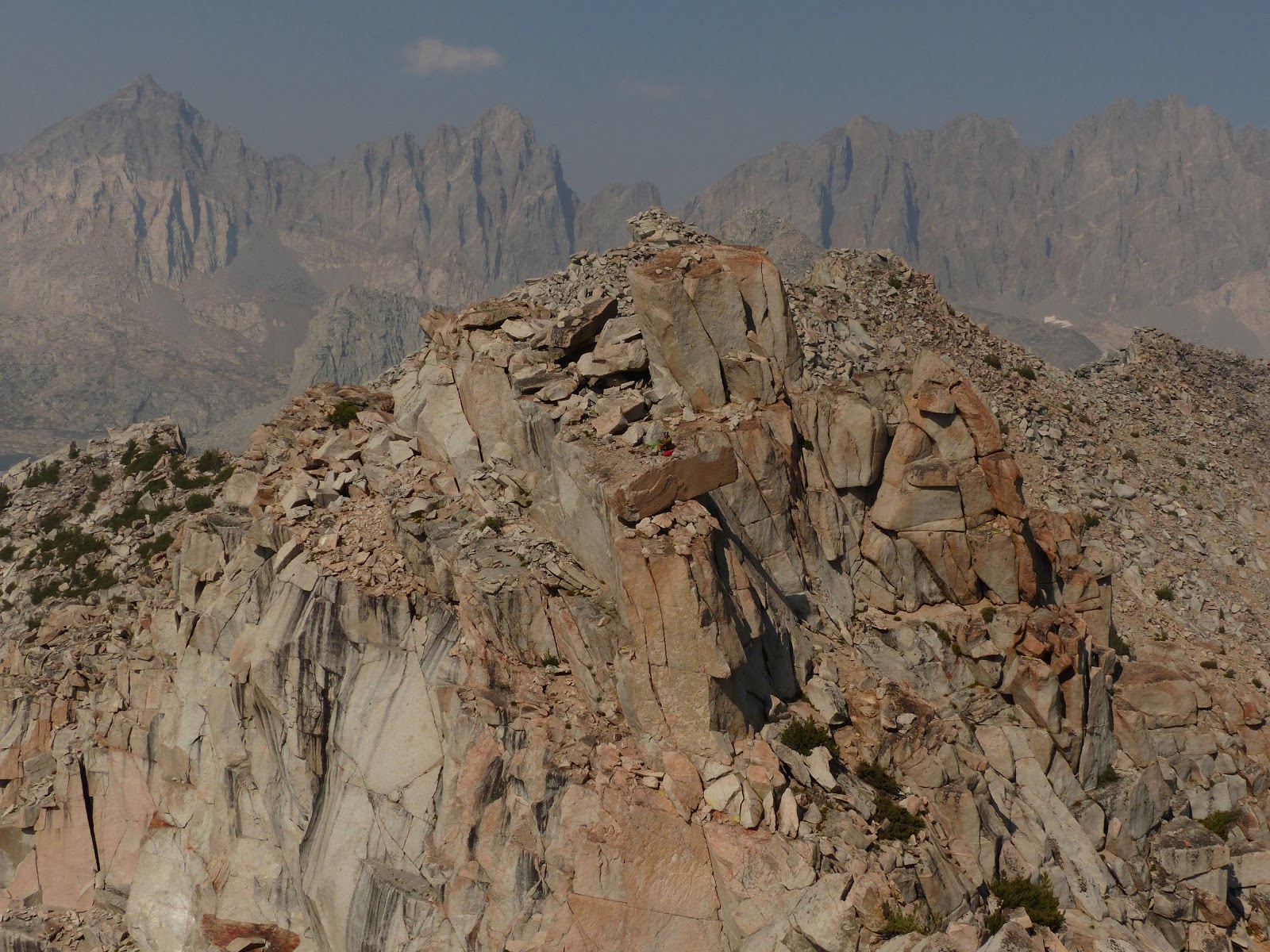
Four of us continued a few hundred feet after the class 4 to find a deep 40 ft gap between us and the true summit. Here we set up another rappel to get into the gap. It was likely down-climbable (low 5th), but there was already a rap station set up, and it was faster to get four people down this way. From the gap, a 5.6 chimney brought us up to a huge sandy/bouldery ledge 20 ft below the summit. Though there were lots of options for protection, none of them were super secure, so I found myself jamming protection about every 4-5 ft. At one point, I pulled off a 20 lb handhold, but did not want to drop it to where it would funnel down the chimney and almost certainly hit one of the guys below, so I carefully placed it on a ledge and shouted down to the others to not grab it. From the huge ledge above the chimney, a few exposed class 4 moves and a low class 5 mantle brought us to the summit block, which while easy to surmount, was still very nerve wracking because it jutted about 25 ft sideways out from the mountain above big air like a diving board. To the southwest, a very tiny Donatas could be seen standing atop Columbine Peak, watching our shenanigans on Isosceles.
false summit of Isosceles


true summit ahead

rappelling into the gap between true and false summits

views from camp


It took about 30 minutes to set up the tents and organize everything before we set off southeast towards Thunderbolt Pass. We first hiked up and over a broad ridge south of camp, then headed east to walk south along a land bridge between two very large lakes. Once on the south side of the larger eastern lake, we headed east, aiming directly for Thunderbolt Pass which was in clear view. The terrain became more bouldery here as we entered an old glacial moraine, but the boulders were surprisingly solid for the most part.

By noon, we had hit the northeast ridge of Thunderbolt Pass Peak which was mainly boulders with one short and exposed class 3 traverse out onto a face to the right. The summit contained a cool old register.


As the ridge progressed west, it was easy travel (class 1-2), until it began curving right. Here the ridge turned class 3 with a drop-off ahead. At the drop-off, we set up a 30 ft rappel. There were plenty of bomber flakes to sling here.


After rappelling, the ridge grew easy again for a short bit before Isosceles Peak. We hiked up Isosceles' southeast ridge for a few minutes before reaching some exposed class 4 moves. At this point, Donatas decided to skip this peak and head off to Columbine, the next peak.
looking back towards the rappel

Four of us continued a few hundred feet after the class 4 to find a deep 40 ft gap between us and the true summit. Here we set up another rappel to get into the gap. It was likely down-climbable (low 5th), but there was already a rap station set up, and it was faster to get four people down this way. From the gap, a 5.6 chimney brought us up to a huge sandy/bouldery ledge 20 ft below the summit. Though there were lots of options for protection, none of them were super secure, so I found myself jamming protection about every 4-5 ft. At one point, I pulled off a 20 lb handhold, but did not want to drop it to where it would funnel down the chimney and almost certainly hit one of the guys below, so I carefully placed it on a ledge and shouted down to the others to not grab it. From the huge ledge above the chimney, a few exposed class 4 moves and a low class 5 mantle brought us to the summit block, which while easy to surmount, was still very nerve wracking because it jutted about 25 ft sideways out from the mountain above big air like a diving board. To the southwest, a very tiny Donatas could be seen standing atop Columbine Peak, watching our shenanigans on Isosceles.
false summit of Isosceles


true summit ahead

rappelling into the gap between true and false summits

looking back down as Michael prepares to belay Mason up the 5.6 chimney

looking towards the lower northwest summit of Isosceles

Donatas atop Columbine Peak

Back above the chimney, we located an old and sketchy rappel station with some webbing pinched between two rocks that looked they they would easily blow with the slightest weight. Not wanting to trust our lives to this, we looked around and found a larger several-ton boulder which was much more trustworthy. The only caveat was that we had to ditch about 15 ft of webbing to wrap around this boulder, but it was a worthy sacrifice. A long rappel brought us well below the base of the chimney and into a chute dropping southwest. Since we had two 60m ropes, we decided to just tie them together and keep rappelling until we hit the moraine below, which did not look too far down. A full 60m rappel brought us about 10m above the moraine. While the rappel itself was loose (Sean later managed to dislodge a boulder and pin down his foot, having to struggle a bit to get if off), the remaining downclimb looked more solid and doable. I decided to downclimb, finding it to be no more difficult than class 4.
setting up the first rappel

Mason rappelling

At this point, the three others were pretty tired, and decided to hike back to camp after Isosceles. I still had some energy left, so I decided to quickly head up Columbine with 15 minutes of sunlight left. A short boulder hop and few moves of class 3 got me out of the moraine and onto the northeast ridge of Columbine. This ridge was a mostly straightforward class 2 boulder hop to the summit, with a little class 3 if one stayed true to the ridge the entire way up. I reached the summit about 10 minutes after sunset, noting a distinct diving board shaped summit block, though not nearly as airy as the one on Isosceles.
views from Columbine's northeast ridge


summit of Columbine

After a few minutes on the summit, it was time to head down the south ridge to Knapsack Pass. Halfway down, I ran into Donatas descending the same way. We continued down a few hundred feet of easy ridge, then noticed a dramatic drop-off that none of us wanted to downclimb. Heading slightly east, we weaved around the side of the ridge, finding lots of class 4 downclimbing. It was getting dark fast, and the prospect of class 4 in the dark did not sound fun. We meandered around and crossed a few more short class 3-4 ribs, and suddenly found ourselves just below Knapsack Pass. It was just getting dark enough to require a headlamp. Success!

From Knapsack Pass, we meandered through a maze of boulders and lakes to get back to camp. Although it was a moonless night, I was able to easily navigate us back with a topo map using the lakes and small rock outcroppings around them which showed up on the topo. It was quite fun actually, and we were back at camp by 9:30pm, with the others having just retreated into their tents for the night.
The next day, we decided to just have a leisurely time getting up and hiking out, hitting a couple easy peaks along the way. Most of us were pretty tired from the day before, and finishing off the traverse would put us back in the Bay Area around 5am the next morning.
hiking out

With excitement from the traverse not yet worn off, Sean and I decided to go back and finish it the following weekend. This time, we would go in as a dayhike and enter the traverse at Knapsack Pass before traversing out the remaining ridge. It was going to be a long (but fun) day, especially since it looked like most of the technical aspects of the traverse were still ahead.
Sean and I groggily started hiking from South Lake about 30 minutes before sunrise. It took us about 3 full miles of hiking to wake up. Both of us were running on very little sleep, with Sean having just climbed several peaks on the Sawtooth Ridge (near Bridgeport) the previous day as part of this year's Sierra Challenge, and me having driven all night to get to South Lake. On my drive over, I had suddenly found the road barely visible through thick smoke which appeared from seemingly out of nowhere. On the other side of the road, numerous cars were pulled over with people gawking at a bright orange glow in the middle of nowhere. A new fire had started below Sonora Pass just a few hours ago. The road was closed 30 minutes after I passed through it, which meant a very sucky 9hr drive back on Sunday through Tahoe (since the other good option, Tioga Pass, was already closed due to a separate fire).
fire below Sonora Pass


Up and over Bishop Pass we went, making it in under 2 hours. We left the trail at the location of our previous weekend's camp, and enjoyed an easy and scenic romp towards Knapsack Pass, which was visible almost the whole time.
back to where we were last weekend


pleasant hike to Knapsack Pass


From the Knapsack Pass, a short and fun class 3 scramble brought us to the top of Knapsack Tower. This is where the business began. The next quarter mile of ridge involved a mix of class 4 to 5.4 climbing, all of it very enjoyable on very solid rock with great exposure. Even the initially blank looking faces contained a plethora of knobs, making for climbing which felt safe and secure. This climbing section abruptly ended halfway (distance-wise) to Stare Peak, where a straight forward rock hop talus slog brought us to the summit of Stare.
ascending Knapsack Tower


a full quarter mile of ridge climbing bliss!


(photos by Sean)


slog to Stare Peak

views from Stare Peak


From Stare Peak, we could now see the full profile of Face Peak's imposing east face. In the middle of this face was a prominent dihedral slanting up to the right. This would be the technical crux of the whole traverse. The first half of the dihedral was easy solid climbing. About 100 ft up, it became choked with larger loose blocks, forcing me to head left on a short section of 5.7 face and up one of several short chimneys to a large boulder strewn ledge. Here I realized the rope was starting to run out, so I slung a large boulder and belayed Sean up. Everything above this point looked fairly chill, so we put the rope away but kept the rock shoes on. About 50 more feet of class 4/low 5th brought us to the summit.
east face of Face Peak

size comparison (photo by Sean)


view from my belay spot

looking down from the summit

hazy summit views


The remaining traverse was more or less straightforward compared to what we had done, but there were still some memorably fun sections remaining. The next section to Connector Peak was pretty uneventful and dull, with about 20 minutes of talus slogging. Hazy skies caused by nearby fires obscured what would've otherwise been an amazing view.
Giraud Peak seen from Connector Peak

Just past the lowpoint between Connector Peak and Giraud Peak was an intermediary bump which we climbed over. We ascended it's east side, then looked for a way to descend west. There was probably an easier way down, but I ended up choosing a 5.4 hand crack which eventually petered out, resulting in a couple thought provoking slab smears. Sean got there, looked around, and decided there was no other immediately obvious easier way to descend, so down the crack he went, eventually deciding that he didn't like the feel of it and setting up a short rappel.
east side of intermediary bump

Giraud gets closer

5.4 hand crack to get off intermediary bump

Sean tries the hand crack

...and dosent like it

setting up a rappel
What lay ahead was Giraud's east ridge, almost all of which was a highly enjoyable class 3-4 scramble. The most solid rock could be found on top of the ridge, which was also the most technical (but rarely surpassing class 4). I didn't want it to end, but eventually reached the summit after around 20 minutes.

COOL!

The relatively unimpressive-looking Roll Peak could be seen to the northwest. This was the last peak on the traverse. I had included it due to the possibility of good views from it's summit, with it's proximity to LeConte Canyon. Getting over to it from Giraud involved straightforward boulder hopping.


The haze had somewhat abated, and we were able to obtain fine views of LeConte Canyon, the Black Divide, and Devil's Crags. The mighty Kings River could be heard thundering several thousand feet below.


We descended Roll Peak via it's northeast ridge, which was mainly class 2 boulders mixed with short sections of class 3. As the ridge began curving left, we headed northeast into Rainbow Lakes Basin, and then further north, bisecting a broad ridge which separated us and the main trail through Dusy Basin.


We hit the trail just after sunset, now feeling decently tired after the long day. There were several miles remaining to get back to South Lake, and I was happy to turn my brain off for most of them while plodding along in the darkness. Our headlamps finally came on at Bishop Pass. I spotted a couple of bright headlamps coming down the scree slope of Mt. Goode, from people who were likely climbing the North Buttress earlier. We finished around 11pm, and headed down into Bishop in search for whatever sparse options of food which were still available at this hour.
Weather Forecasts
South Lake
traverse
Peakbagger Pages
Isosceles Peak
Columbine Peak
Face Peak (aka. Knapsack Pass Peak)
Giraud Peak
Summitpost Pages
Isosceles Peak
Columbine Peak
Giraud Peak
LOJ Pages
Isosceles Peak
Columbine Peak
Face Peak (aka. Knapsack Pass Peak)
Giraud Peak
South Lake
traverse
Peakbagger Pages
Isosceles Peak
Columbine Peak
Face Peak (aka. Knapsack Pass Peak)
Giraud Peak
Summitpost Pages
Isosceles Peak
Columbine Peak
Giraud Peak
LOJ Pages
Isosceles Peak
Columbine Peak
Face Peak (aka. Knapsack Pass Peak)
Giraud Peak
No comments:
Post a Comment