
March 29, 2018
La Quinta is a resort town in the Coachella Valley, nestled in a roughly 7 square mile cove in the northeastern Santa Rosa Mountains. The surrounding serrated ridges rise only 1-2,000 ft above the desert floor, but do so very dramatically. They had caught my eye in 2015 while scanning maps of the Santa Rosas for the nearby Santa Rosa Traverse. After an hour of fiddling with the map, the La Quinta Traverse idea was hatched. I divided the traverse into four distinct parts, starting from a typical shopping plaza near Point Happy just north of La Quinta. The first part was a roughly 7.5 mile stretch of dominant ridge between Point Happy and Coyote Benchmark, surrounding the north and west sides of La Quinta. The second part wrapped around the south side of the cove, characterized by a series of washes and low craggy hillsides as there was no single dominant ridge. The third part was about a 3 mile stretch of rugged ridge bordering the eastern side of La Quinta, surrounded by several fancy golf courses. The fourth part was where the cove opened up onto the desert floor on its northeast side, and would involve walking several miles of city streets to get back to the start.
I had first attempted to dayhike this traverse in December 2016 with Gus, bailing from the ridge just after a few peaks due to the fact that we would not be able to finish before dark, not wanting to climb class 3 ridges on a moonless night. Now on March 29, there would be significantly more daylight (as well as moonlight). I planned to start from Point Happy at around 2am, hopefully finishing the last ridge sections by sunset. Daytime temperatures were expected to exceed 90 degrees, so I made sure to pack just over 3 gallons of water for the day. Though Gus was still interested in finishing the route, he had to work this day, so I headed off solo.
| Peak | Elevation | Topographic Prominence | Summit Coordinates (lat/lon) |
|---|---|---|---|
| Point Happy | 220 ft | 130 ft | 33.7167, -116.2983 |
| "Up down peak" | 638 ft | 298 ft | 33.7060, -116.3003 |
| La Quinta Benchmark | 1,253 ft | 353 ft | 33.7040, -116.3127 |
| "Bendy Peak" | 1,276 ft | 376 ft | 33.7049, -116.3247 |
| Eisenhower Mountain | 1,952 ft | 292 ft | 33.6919, -116.3374 |
| "Rock Hop Peak" | 2,100 ft | 280 ft | 33.6826, -116.3379 |
| Indio Mountain | 2,226 ft | 726 ft | 33.6711, -116.3428 |
| Coyote Benchmark | 2,613 ft | 1,153 ft | 33.6504, -116.3475 |
| "Razorback" | 1,481 ft | 170 ft | 33.6423, -116.2982 |
| "Quinta Island" | 1,601 ft | 1,061 ft | 33.6464, -116.2959 |
| "Golf Peninsula" | 1,484 ft | 462 ft | 33.6560, -116.2878 |
I arrived at the Top Of The Cove, a community park just south of La Quinta at 11pm the previous night. My plan was to catch a few hours of sleep there before driving over to Point Happy to start the traverse at 2am. I spent the first hour tossing and turning (It was so hot there) and not feeling sleepy at all. Around midnight, a few local kids pulled into the large dirt lot with stereos booming. A musty smell of skunk weed and dust filled the air. Still no sleep. Around 1am just as I was starting to drift off, another car pulled in. The faint sound of a car door opening and closing and a female voice laughing sounded somewhere off in the distance, followed shortly after by equally faint moaning sounds which gradually grew louder. "Fuck this," I thought, as my sleepiness once again faded away. I threw my blanket in the back and started driving over to the traverse. It would've been much better to just sleep at one of the pullouts off Hwy 74.
I pulled into the much deserted but very well lit shopping plaza at 1:50am, taking a few moments to rearrange gear before shouldering my heavy pack filled with water, which weighed over 30 pounds. I was thinking that someone from one of the nearby businesses would come out and question what I was doing (the truth of which would likely still seem super strange to them), but no one ever did. Just after 2am, I set off up the east side of Point Happy, which started directly from the parking lot. It took less than 3 minutes to reach the summit. This really wasn't an impressive peak, merely a tiny bump at the start of a long ridge.
summit of Point Happy

Just south of Point Happy, Highway 111 made a perpendicular cut through the ridge. Luckily just to the west of the ridge, a dry canal cut right under the highway. I descended the northwest side of Point Happy and into the canal (I could've descended directly west past what looked like a steakhouse, but there was a parked car there with lights on which I did not wish to disturb). After following the canal roughly 1,500 ft southward, I once again turned southeast towards the ridge, bushwhacking through a particularly nasty 5 ft section of parallel roadside shrubbery to bypass the gate of a gated community (just about all communities in the Coachella Valley are gated), walked through the quiet residential area, and finally tip toed through a gap between two large homes and up the scrambly ridge.
The canal bypassing Highway 111 (Photo by Bob Burd)

The ridge started off quite steep, and definitely woke me up as I pressed onward. I hit the first peak (Up Down Peak) at 2:25am, which felt like an island surrounded by endless miles of golf courses and fancy gated neighborhoods.


summit view from Up Down Peak

From Up Down Peak, the ridge made an almost 90 degree turn to the west. Getting immediately off the peak involved some loose class 3 downclimbing, which sent several boulders careening off the mountain into surrounding gullies. A series of four large pinnacles stood between Up Down Peak and La Quinta Benchmark to the west. Most of them involved some form of class 3 climbing. From previous experience, the first three were very difficult to bypass, so I went right up and over them. The last one was bypassable on its north side, but it only cut off around 20 ft of gain at most. La Quinta Benchmark's east ridge was a straightforward boulder hop.
summit of La Quinta Benchmark


Apart from a few class 3 boulders to get off La Quinta Benchmark, the connecting ridge to Bendy Peak was pretty straightforward. At 4am, the temperature was still 78 degrees with nary a breeze. I was sweating like crazy. The moon finally set over the San Jacinto Mountains to the west, and for the first time I turned on my headlamp. A friend who lived roughly 5 miles north told me later that he had looked out to see my single light on the ridge, clear as day.
summit of Bendy Peak

The ridge between Bendy Peak and Eisenhower Mountain once again grew tedious, but was still fun, consisting of short knife edgy sections held together by what looked like dried mud. As unstable as that sounds, they were still stable enough to hold numerous stacks of large boulders, so I assumed they were stable enough to hold me.
The sun rose just as I was ascending the last few hundred feet up to Eisenhower. I stopped on the summit to eat a quick bite. One of my three gallons of water was already gone. This was starting to seem a little sketchy with water. Worst case scenario, I could later head into La Quinta to fill up on water before resuming the traverse. Its not like it would take a large amount of time to go down there and come back up to the route.


summit of Eisenhower


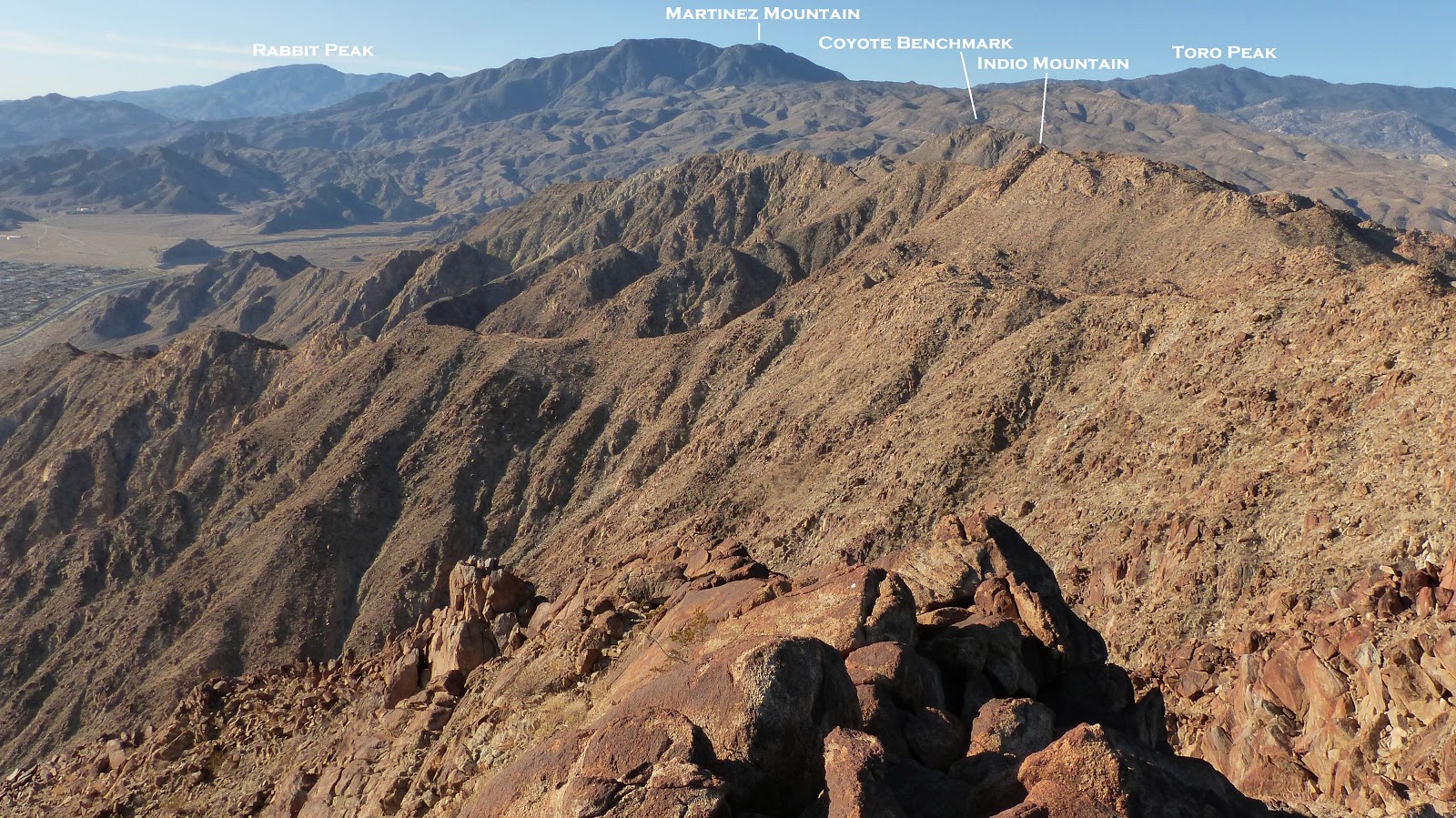
The next three peaks after Eisenhower would involve nothing more than class 2. The views were some of the most unique I had ever seen. Dramatic rocky ridges rose abruptly from the developments below, with their browns and reds contrasting intensely with the greens and blues of scattered golf courses. The terrain was tedious boulders and it was intensely hot. By the time I got to Coyote benchmark, it was already 90 degrees and I only had a gallon of water left. I had been trying to conserve water, but it still looked like I was gonna run out. I texted someone who lived in La Quinta about possible nearby locations for obtaining water, but lost reception as I descended the southeast ridge of Coyote, still trying to conserve my last gallon. I could've easily bailed (which is not very difficult to do from any part of the traverse, really) but I was stubborn and didn't want to.


Descending the southeast ridge of Coyote Benchmark was easy at first, but then abruptly became impassable as it turned into a sudden knife edge made up of entirely soft dry mud. Not wanting to risk climbing over it, I dropped south towards a large wash, using a small class 3 gully of dried mud. It was a little sketchy and loose, and I took a few short tumbles, one of which resulted in my right leg slamming against a thorny ocotillo.
descending Coyote's southeast ridge


the class 3 gully I downclimbed to get off the ridge


The large wash ran east and then north, directly towards the Top Of The Cove. I felt really weak and dehydrated and rested in the shade of a large boulder. Realizing that there was once again reception, I checked my earlier text to see a reply mentioning an oasis a short distance north, located on the east side of a bump (spot elevation 577 on the USGS 7.5' map). Feeling elated, I chugged a full half gallon of water and headed towards the oasis. Just following the wash would take me almost all the way there already. There were a few dry waterfalls to downclimb, but they were no more than class 3.
An obvious stand of palm trees marked the spot I was to head towards. Upon reaching it, I located a drinking fountain and poured a gallon of water over my head. It was over 95 degrees and it didn't really make sense to continue until it at least got a little cooler, so I laid down in the shade and took an hour long nap.
the oasis

At 4pm, I got back up and began marching east towards the eastern set of ridges which made up the main traverse. A network of trails would take me to the southwest side of Razorback, which had looked especially impressive from the western ridges earlier.

Tired and slightly nauseous, I started up the steep southwest ridge of Razorback, which was mainly class 2 except for the last section below the summit. Temperatures had now dropped into the low 90s, and a slight breeze had began picking up.


summit of Razorback


The next two peaks would be relatively straightforward following the main ridge. Short bouts of nausea would accompany me up the peaks. As the sun dipped lower, I watched as long shadows of the San Jacinto Mountains gradually crept eastward across the Coachella Valley. It was memorizing how expansive the flat desert floor was, stretching all the way from the foot of the San Jacintos to the Salton Sea.


I reached the last peak just after sunset, sitting down briefly to force down an energy bar before continuing. Since it was already beginning to get dark, my new plan was to simply shortcut west down a gully and into one of several golf course communities which bordered the traverse. The gully I ended up choosing was straightforward with class 2 boulders.

A faint glow remained on the horizon as my feet finally hit pavement and I began walking through a residential area which wound through the golf course, past homes which were each valued at several million dollars. Some of the windows had faces peering out from them, staring at my slumping body with tattered clothes and a tattered backpack, and a very clear trail of blood running down my right leg. It all had a very comical feel in my exhausted state. Before long, neighborhood security drove by and offered me a ride to the entrance. This cut off 1.6 miles from the deproach, which was very welcome since the temperature was still somewhere in the 80s. A 3 mile walk northwards on Washington St brought me back to Point Happy. A few curious faces briefly peered out of passing cars at the hobo figure walking on the shoulder. It felt strange now being back in the city bustle after looking down on it all day from the traverse. To the west, the main ridge was silhouetted dramatically against the night sky.
Final Stats
21.1 miles
9,320 ft gain/loss


Weather Forecasts
desert floor
traverse
Peakbagger Pages
Point Happy
La Quinta Benchmark
Bendy Peak
Eisenhower Mountain
Indio Mountain
Quinta Island
LOJ Pages
Point Happy
Up Down Peak
La Quinta Benchmark
Bendy Peak
Eisenhower Mountain
Rock Hop Peak
Indio Mountain
Coyote Benchmark
Quinta Island
Golf Peninsula
Some photos from my previous failed attempt (December 14, 2016)
view from La Quinta Benchmark

looking towards Bendy Peak from La Quinta Benchmark

moon setting over Mt. San Jacinto

ridge between Bendy Peak and Eisenhower Mountain


bailing off the traverse and into La Quinta

I grew up in the cove and love this traverse! I'm setting up a couple different FKT variations for the FKT website (Full from Vons and also west ridge from saddle between Coyote and Indio Mtn to Vons. I cant find any of my old pics. You have BEAUTIFUL pics! Would you be ok with me using 6 of them to set up the page on the site? Id greatly appreciate it! Thanks for the trip report too! Glad to see others are doing it!
ReplyDelete