
August 31, 2013
There are a total of seven points in the San Jacinto Mountains of Southern California that rise above 10,000 ft, which a few locals have affectionately referred to as the Seven Summits of San Jacinto. I had first learned about these seven summits through an interesting trip report where "Hikin' Jim" had strung them together into a lollipop loop hike.
| Peak | Elevation | Topographic Prominence | Summit Coordinates (lat/lon) |
|---|---|---|---|
| Marion Mountain | 10,362 ft | 242 ft | 33.795764, -116.687014 |
| Shirley Peak | 10,388 ft | 50 ft | 33.799959, -116.682873 |
| Jean Peak | 10,670 ft | 230 ft | 33.80615, -116.679197 |
| Newton Drury Peak | 10,160 ft | 160 ft | 33.808272, -116.6865 |
| Folly Peak | 10,480 ft | 80 ft | 33.818199, -116.684786 |
| San Jacinto Peak | 10,834 ft | 8,319 ft | 33.814785, -116.679477 |
| Miller Peak | 10,400 ft | 40 ft | 33.815283, -116.673041 |
I started off on the Marion Mountain Trail on a Saturday morning with a group whose goal was to hike up San Jacinto Peak. We had left the Marion Mountain Trailhead (6,300 ft) at 8:31 am. I was going to check out a few other peaks along the way, and we planned on maybe meeting up on San Jacinto's summit.
Marion Mountain Trailhead

morning on Marion Mountain Trail

The first two miles of the Marion Mountain trail have a reputation for being steep. The overall trail itself is known for being part of the shortest and steepest route up to San Jacinto Peak. As I hiked up along it, it didn't seem as bad as some had said. There were bits of steep trail here and there, but they were separated frequently by short sections of almost-flat switchbacks. The Marion Mountain Trail itself was short, lasting less than 3 miles before merging into the Deer Springs Trail.


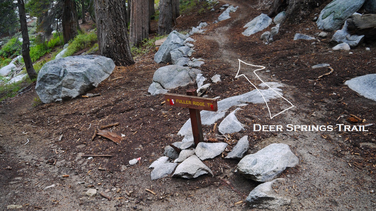
I continued up the trail past two junctions, at all of which I followed the signs for Mt. San Jacinto. About 3.2 miles from the trailhead, I had reached the Deer Springs Trail/Fuller Ridge Trail junction (8,900 ft) and took a took a right to stay on the Deer Springs Trail. There was a sign at this junction, but it only labeled the Fuller Ridge Trail.
Shortly after this junction, the trees gave way to patches of dense manzanita. I was nearing the part where I would start making my way off trail towards Marion. After a few switchbacks, the manzanita had thinned out considerably, and I took off cross country southeast up a slope.
view towards Castle Rocks after Deer Springs junction

beginning of cross country southeast

fog rolling in

As soon as the slope began flattening out, Marion Mountain appeared to the south. The highpoint was easy to spot due to its signature summit block.

I headed directly south, aiming for the left side of Marion's summit block.

From the left base of Marion's summit block, a zigzag crack appeared behind a dead tree. On the other side of this crack was a bigger one heading directly up and to the summit. This second crack required a few easy class 3 moves.

Marion's summit block viewed from the northeast (photo taken on 11/3/12)

I reached Marion's summit (10,362 ft) at 10:50 am to find a nice cool breeze blowing from the south. It was nice to get a respite from the warm humid air that had been present so far that day. The original register for Marion was ripped out, as evident by a wooden plank nailed to the block. I did notice a red register can jammed into a crack, but it was too far in for my reach.
view northeast from Marion

Five of the six remaining peaks could be seen from Marion (Newton Drury & Folly are slightly out of frame, photo taken 11/3/12).

From the summit of Marion, Shirley was not an obvious looking peak. It seemed to melt right into the ridge between Marion and Jean. As I descended Marion heading northeast, Shirley became more distinct.

Shirley turned out to be a straight shot from Marion. After reaching a lowpoint between the two peaks, Shirley's gradual Southwest Ridge was easily located and followed up. This was one of those peaks that could be climbed from any possible direction without the terrain exceeding an easy class 2 rating.
view southwest towards Marion from Shirley's summit (10,388 ft), 11:14 am

northeast

Shirley's summit contained a register which referred to the peak as "LePake Peak," but I will go with the widely accepted name. And besides, "Shirley" sounds like a much cuter woman than grumpy ol' LePake.

The traverse between Shirley and Jean was straightforward, following the main ridge northeast from Shirley. One false summit of Jean's, which could be bypassed on both sides without difficulty, stood in between the two peaks.
view of Newton Drury Peak from the ridge between Shirley and Jean

Jean's summit (10,670 ft) was a flat plateau-ish sort of area. Trees blocked off views in every direction except towards Marion. Jean's highpoint was a 5 ft block that could be climbed with a short friction move.
view southwest from Jean, 11:36 am

To get to Newton Drury from Jean, I descended a short ways down Jean's North Ridge, then picked up a small spur ridge that headed west connecting to Newton Drury.
view of San Jacinto and Miller from Jean's North Ridge

spur ridge to Newton Drury

Folly Peak shrouded in clouds

Newton Drury getting closer

Upon reaching Newton Drury's summit (10,160 ft) at 11:57 am, I was surprised to see that it contained some nice panoramic views, a quality which had not occurred to me based on its low stature. The clouds were moving in fast, so I hastily signed the register and snapped a few pictures. Another group had also converged on the summit. It seemed like they had come up from Little Round Valley.
east

southeast

fun looking block (southwest)

northeast

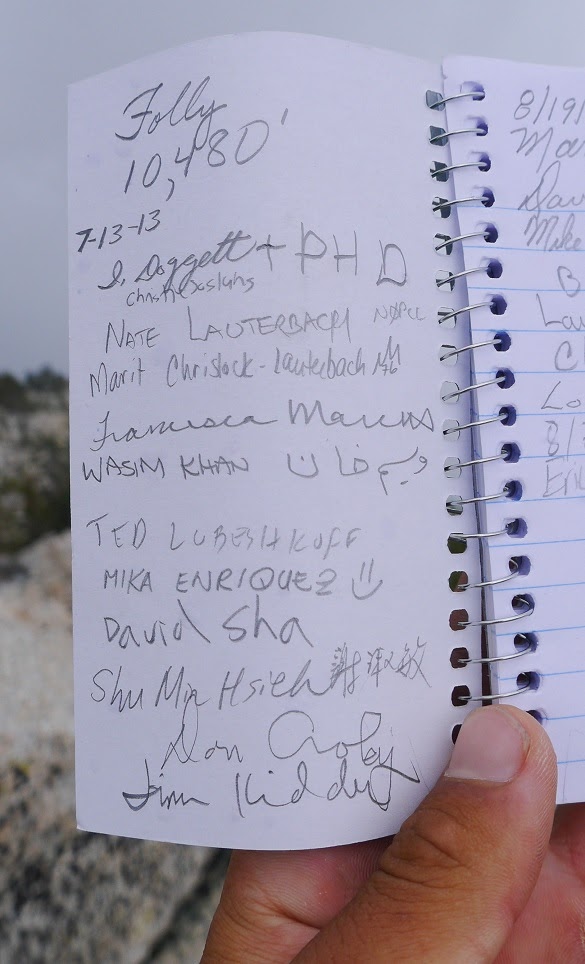
From Drury, I descended north and was able to intersect the Deer Springs Trail just above Little Round Valley. From there, I hiked up the first few switchbacks heading towards San Jacinto Peak, then left the trail to climb north up towards Folly Peak. After the first few hundred feet of off trail, the terrain became chocked up with manzanita, prompting me to climb up and slightly towards the right (northeast) to avoid it. Pretty soon the lowpoint between Folly and San Jacinto appeared ahead, and the manzanita thinned out. It was now clear to contour northwest to Folly's summit (10,480 ft).
views south while ascending Folly


summit of Folly

view south from summit, 12:32 pm

northwest

southeast

summit register
From Folly, I headed southeast towards San Jacinto Peak along a connecting ridge. There were cairns placed in several spots along the ridge, but they served little purpose since all anyone had to do was to stay on or near the ridge. The second half of this traverse consisted of enjoyable class 2 granite and the occasional ducking under low hanging tree branches. The views here would probably be insane on a clear day.


San Jacinto Peak, 12:56 pm

A steady rain shower engulfed the peak as I summited, but it didn't last long and soon began to clear out. Clouds were swirling about, making interesting designs in the trees. A few deep rumbles of thunder sounded to the north, likely over Mt. San Gorgonio.
San Jacinto Peak views


After 25 minutes on the summit, I headed down San Jacinto's class 1 Northeast Ridge towards Miller Peak. An old unmaintained trail appeared and disappeared along the ridge. Miller Peak lay just east of a flat area locally known as "Miller Saddle." From there, its a easy class 2 scramble up Miller's summit block (10,400 ft).

Miller Peak views, 1:34 pm


After a few minutes on Miller, I headed back up San J to see if my group had summited. Not finding them there, I began jogging down the Deer Springs Trail.
back on San J


The jog down was very pleasant as a steady breeze picked up. The skies darkened, indicating possible afternoon thunderstorms. A thick fog descended over the Marion Mountain Trail, making for a nice change of scenery. Along the way I passed the group I had met on Newton Drury Peak. One of them said that my group was about an hour ahead. I quickened my jog, wondering shortly after how the heck a random person I had met on a summit knew which group I was with.
The air grew warm and muggy closer to the trailhead- a somewhat typical weather pattern for this area in summer months. I reached the trailhead at 3:20 pm to find three people in my group changing into sandals and popping beers, having gotten back five minutes ago. After a few more moments, we packed up and left before any afternoon thunderstorms could arrive. It had been another great day in the local mountains.
fog along Marion Mountain Trail


Final Stats
14.4 miles
7,000 ft gain/loss

Weather Forecasts
Trailhead
all peaks
Peakbagger Pages
Marion Mountain
Shirley Peak
Jean Peak
Newton Drury Peak
Folly Peak
San Jacinto Peak
Miller Peak
Summitpost Pages
Marion Mountain
Jean Peak
Newton Drury Peak
Folly Peak
San Jacinto Peak
Miller Peak
Other
Mt. San Jacinto message board
Pacific Crest Trail Association
Webcam at 8,000 ft elevation near Mt. San Jacinto
Nice trip report and pix -- particularly of Jean Peak.
ReplyDeleteHJ