
August 20, 2013
A handful of us gathered at Red Lake Trailhead on day 5 of the 2013 Sierra Challenge. The main objective for this day was Twin Peaks, which was located 0.6 mi northeast of Mather Pass. Getting to the peak would involve ascending Red Lake Drainage, a route that was said to be steep and tedious. I had been in the area before to climb Split Mountain and Mt. Prater, but had approached from Taboose Pass- a much easier route. I considered my options for climbing bonus peaks, and decided to climb Mt. Prater first, traverse northwest to Mt. Bolton Brown, then finally drop southwest towards Twin Peaks.
| Peak | Elevation | Topographic Prominence | Summit Coordinates (lat/lon) |
|---|---|---|---|
| Mt. Prater | 13,471 ft | 118 ft | 37.036763, -118.434671 |
| Mt. Bolton Brown | 13,491 ft | 598 ft | 37.0461, -118.440937 |
| Twin Peaks | 13,061 ft | 430 ft | 37.036183, -118.451993 |
Getting to the trailhead
Trailhead coordinates (lat/lon): 37.036605, -118.360030
A small group of us met at Red Lake Trailhead (6,600 ft) for a 5am start. (photo by Bob Burd)

The Red Lake Trail turned out to be an excellent morning workout. Since this trail was unmaintained, there were a few spots where it seemed to vanish, but we would always manage to easily relocate it. The initial two or so miles were soft and sandy, ascending steeply along the north side of Red Mountain Creek. There would be no access to water until 2.5 miles in. Beginning at 2.5 miles and lasting for about a quarter mile, the trail merged with a creek, ascending through a thicket of overgrown brush. After the thicket, the trail became more defined as it switchbacked up towards Red Lake.
As the hours went on, the group spread out along the trail. There wasn't much socializing going on as everyone was concentrating on their breathing instead. As the sun rose, I could already begin feeling warm waves of heat rising up in updrafts from the desert below- a likely sign of thunderstorms later that day.
dawn from 8,600 ft

9,000 ft


above the thicket


At 10,150 ft, a small lake came into view. At first glance, one may think this was Red Lake, but it is a smaller lake before Red Lake that is often mistaken for it. The actual Red Lake lay a short distance further up.
Split Mountain reflected in "False Red Lake"

The trail began to slowly fizzle out as it meandered along the north side of False Red Lake. There were several cairns that marked the route, but they were not necessary as the terrain was easy to navigate. After False Red Lake, the trail appeared again briefly and finally disappeared completely shortly before Red Lake.
As I was filling up on water at Red Lake (10,450 ft) thinking that it was the last water source, Pat caught up and mentioned that there was a reliable source higher up at a "green patch"- the highest patch of green vegetation that grew in the drainage. Since Pat had been there earlier that year to climb Split Mountain, the information seemed reliable, and I dumped out the water.
looking up the drainage from Red Lake

After Red Lake, Pat and I hoofed it up the drainage together, encouraging eachother onward. The terrain quickly changed from soft to rocky, composed of small bits of talus.
above Red (?) Lake


The green patch (11,300 ft) contained a steady gurgling creek, and we gratefully filled up our bottles. Not far above the green patch, the terrain turned to moraine talus and rock hopping. Ahead of us was the part of this route that many people have messed up on: picking the right notch to aim for in order to access the Sierra Crest on Split Mountain's North Slope (I will refer to this notch as "Point 12,980 ft"). Three prominent notches appeared above us. Neither of them was the correct one, which lay to the southwest (left) of the three notches and was considerably more difficult to spot. We had initially ascended to the leftmost of the wrong notches, realized our mistake, and crossed over to the correct one.

view from the leftmost wrong notch

The terrain in the chute up to the correct notch contained much loose and crumbly rock, some of it class 3. Luckily, this chute was short and we found ourselves standing at Point 12,980 ft sometime around 8:30 am.
From Point 12,980 ft, Pat and I headed in our separate directions. Pat headed towards Twin Peaks, and I headed northwest towards Mt. Prater.
The route to Prater was pretty self explanatory. The terrain was easy class 2 at most, and the rocks were generally solid. The only exposed part was a ~20 ft long narrow class 1 ridge right below the summit.

views while ascending Prater


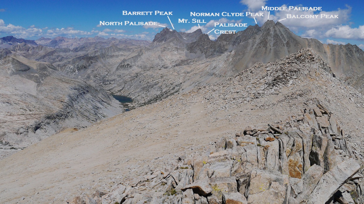
view northeast from Prater's summit

southeast

south-southwest

southwest

north-northwest

From Prater, a short section of gendarmes, ribs, and chutes lay in between it and a soft section of ridge in between Prater and Bolton Brown. Closer to Bolton Brown lay another similar (but longer) section of gendarmes, ribs, and chutes.
Getting from Prater to the soft ridge proved not to difficult. I first descended west off Prater on class 4 terrain, then traversed NNW along the ridge on class 3 terrain to the right side of several gendarmes.
looking back at Prater from the class 3 terrain

The soft part of the ridge was straightforward class 1.

view of Tinemaha Drainage and a gendarme

As I approached the second set of gendarmes, ribs, and chutes, I generally stayed as high on the ridge as possible, which consisted of class 3-4 terrain on semi-loose rock. When an obstacle blocked further access along the ridge, it was possible to drop down to the east (right) on class 4 terrain to bypass the obstacle.

The crux of the route came at a lowpoint just before Mt. Bolton Brown. It was getting more difficult to stay on the ridge, so I dropped down to the right. There was a ledge that ran parallel to the ridge, descending into a prominent gully. This ledge was covered with a considerable amount of loose crud. From above, it seemed that the ledge suddenly dropped off into the gully. The drop itself was not visible from above.

As I reached the dropoff, I saw that the ledge had given way to a chute to the left and a rib to the right. The key was to access the chute using the rib. It was not possible to immediately drop into the chute due to a blockage by a chockstone. The rib descent contained some exposed class 4 climbing, which was made further difficult by a small amount of wet sand that had accumulated on the rocks, making them slippery. Getting off the rib and into the chute involved a few class 5.3 moves, but at least those were protected (If I fell, I would only fall as far as the chute below me). I slogged down the last few feet of wet, sandy chute, crossed the prominent gully, and began climbing a short section of class 4 rock on the other side of the gully.
looking back at the crux (image stitched from three separate photos)

The class 4 ended abruptly as the ridge began to flatten out before Bolton Brown. The last few hundred feet to Bolton Brown contained easy class 2-3 climbing.

The views from Bolton Brown were amazing, and I could see a clear route to Twin Peaks. It looked much easier than the traverse from Prater.
view southwest from Bolton Brown summit


northeast

south

After the initial few class 3 moves to get off of Bolton Brown's summit block, the rest of the traverse to Twin Peaks was all class 1-2. Twin Peaks contained north and south summits, with the south one being higher. I accessed the south summit by climbing the East Slope of Twin Peaks to the saddle between the north and south summits, then walking over to the south summit. The ascent of the East Slope was uneventful, composed of much sand and talus. Upon reaching the summit, I saw that a handful of Challenge participants (including Bob and Pat) had already signed the register. I snapped a few photos, ate a quick snack, and began slogging back down the East Slope and towards Point 12,980 ft above the Split-Prater saddle.
view south from Twin Peaks summit

southwest


northwest
northeast

east

southeast

The key thing to remember about getting to Point 12,980 ft from the west is that Point 12,980 ft is not the lowest point between Prater and Split. I purposely ascended to a point below Point 12,980 ft instead of aiming straight for it, and gradually ascended the slope as I scanned for the chute leading down into Red Lake Drainage. Later that day, Michael Chapiro, another Challenge participant, had made the mistake of descending at the lowpoint between Split and Prater, descending into Tinemaha Drainage. Too tired to climb back up, he continued down the drainage, which contained miles of tedious rock hopping and bushwhacking, finally meeting up with a road after dark. At this point, Michael seemed to realize where he was, and began walking in the direction of Red Lake Trailhead. Around the same time, the two people Michael had carpooled with earlier that morning were leaving the trailhead. They were tired and hungry, and would not wait any longer. Luckily, the saw an exhausted Michael walking the road on their drive out, and picked him up.
At the chute, I ran into JD who was descending solo. He had just gotten back after a successful summit of Split Mountain.
descending into Red Lake Drainage


back at the moraine field- fun! fun! fun!

Red Lake

Not far above Red Lake, I ran into Bob and Jonathan. Jonathan was crouched down in a patch of vegetation, eating berries. As soon as he saw me, he abandoned his berries and ran after me. As we reached the trail, we jogged down together. On the trail, we passed by several bushes containing unusually large Sierra Gooseberries (the thornless type). They looked so delicious and juicy that I had to stop and cram several of them into my mouth before running after Jonathan.
False Red Lake

view down the drainage

As low rumbles of thunder began to sound from the east, we quickened our jog downward. Somewhere along the line, Jonathan had to stop. I continued running and met up with Tommey not far above the trailhead. He pointed out a shortcut that would shave up to 15 minutes off our times. When the trailhead was visible, we heel-plunged straight down the slope on very nice, soft, sandy terrain, descending hundreds of feet in a matter of minutes. I got back to the trailhead at 3:07 pm to find Pat, who had gotten back about 20 minutes prior. We waited at the trailhead for a couple more hours as more participants began trickling in.
Tommey running the home stretch

Final Stats
16.6 miles
11,050 ft gain/loss

Weather Forecasts
Trailhead
Red Lake
All peaks
Peakbagger Pages
Mt. Prater
Mt. Bolton Brown
Twin Peaks
Summitpost Pages
Mt. Prater
Mt. Bolton Brown
Other
Bob Burd trip report
High Sierra Topix message board
Inyo National Forest
No comments:
Post a Comment