
December 24-25, 2012
I recently "discovered" this trip report in my archives. It was one of the first reports I had ever written but had never gotten around to releasing. Im releasing it now as a kickback to the days when I had little to no mountaineering experience, and would go on trips to big mountains and into harsh weather with little to no planning. This report details everything you should NOT do on a winter mountain trip, so please do not follow my example. Everything in the report (including grammatical errors) are left in the way it was originally written in 2012.
------------------------------------------------------------------------------------------------------------
"Charleston Peak. Look at it on the map. Look how easy it is to climb. Look how close it is to Vegas. Its even a DPS emblem peak. We could climb it in no time with little effort. It will make for a fantastic winter hike."
This is what Tommey and I were saying to eachother as we sat in his car in the parking lot of a shopping center in Cabazon, reading the Summitpost article on a laptop. It was around 7:30pm on 12/23. We had just climbed Mopah Point and Umpah peak in the Mojave desert with Pat. Pat had gone home to spend time with her husband and would meet us again later that week. The remaining two of us had planned to climb Cardinal Mountain in the Sierras after seeing that a 2-day weather window had opened up on the 24th and 25th. But as we checked the weather at the end of the day, the window had closed to only one day- the 25th. Even that day was showing strong winds. We decided to scrap the idea, thinking how much of a waste it was to bring all our winter gear and not use it. I started looking up peaks in the desert, coming up with the Fountain/Edgar/Mitchell traverse that looked interesting, but remembered that a friend had wanted to climb it with us, so we scrapped that idea too. We finally decided on linking together a bunch of easy peaks near Red Rock Canyon, but as we played around with Google Earth finding peaks, a big mountain in the background caught our eyes- 11,918 ft Charleston Peak.We checked out the Summitpost page and a couple of trip reports. It looked like the best winter route was the South Loop Trail which starts from the end of a picnic area out of the town of Mt. Charleston. The trail is 8.3 mi one way with 4,300ft gain, and since we would be hiking it as an out-and-back, it would be a total 16.6 mi. The trail switchbacks up to a ridge for 4 miles, then contours the southern side of the ridge for 4.3 miles, gradually ascending up to the summit. When the trail intersects the ridge, it passes by Griffith Peak, a good bonus. The weather forecast indicated snow Sunday night, clearing up by Monday 10am. It looked like another storm was due for Wednesday (The forecast didn't indicate this yet, but I had a feeling it was coming because a big snowstorm was supposed to slam into the Sierras 135 miles to the west on Tuesday night). Temperatures were supposed to hover in the mid teens at 10,500 ft elevation, and the wind was supposed to peak on Monday night between 20-30 mph.
We discussed our plan while on the 300 mile drive from Cabazon to the trailhead, and eventually decided on heading over to the trailhead that night and sleeping in the car. We would start climbing the next morning when the snow stopped. It looked like some people had done Charleston as a dayhike in winter, but since we had stumbled across this hike at the last minute and barely knew anything about it, we decided to play it safe and do this climb as an overnighter. Dayhiking it like this would be foolish. We were, however, convinced that this hike was going to be fairly easy and straight forward. The weather didn't look bad and the mileage and elevation gain (even with snow) was trivial compared to what we've done on our past Sierra climbs. The plan was to climb up to the peak on Monday and camp up there, catching the summit sunrise Tuesday morning. We would descend back to the trailhead on Tuesday, hitting Griffith Peak along the way if there was time.
We entered Vegas city limits just after midnight. The sky was clear with only a few puffy clouds. No sign of a storm here. It was probably concentrated only in the mountains. Sure enough, as we left Vegas and started up SR157, a large rolling mass of cloud blanketed the distant mountains. The tops of the clouds were lined silver by the almost-full moon, making them appear eerie and ghostly. The snow level started at around 5,000 ft. It was impressive how good the roads were kept. They were plowed and sanded on a regular basis, even with a very slight dusting of snow. We passed by the entrance road to the trailhead, which was blocked by a locked gate. A hundred feet after the gate, where were a row of vacation lodges. We parked at the end of the row. There was an open dumpster 50 ft away, which was good because it indicated that there were few or no bears in the area. Tommey pulled out some Kimchi he had brought from home and we had a quick snack. It was pretty good. A man came out from one of the lodges and asked us what we were doing there. We explained our plan to climb Charleston. He mentioned that the trailhead was closed because of construction and we would be kicked out should anyone see us entering. We thanked him for the info, which was very helpful, but did not deter us from proceeding.
The next morning we woke up at around 7am. It was still snowing outside. An inch or two had fallen overnight on top of the 8-10 inches already on the ground. The sky was starting to clear towards the east. We ate breakfast, mixing Mountain House rice and beans with Kimchi and beef. It actually tasted pretty good. At 8:30, the weather had showed great signs of improvement. The snow had stopped and the sky above us had almost cleared. Storm clouds were still obscuring the prominent ridges and peaks. Two people- a man and woman, walked towards the trailhead on the main road. They looked like hikers carrying daypacks. I hurried over and asked them if they were hiking. They said that they were planning to dayhike to Griffith. The man told me that the actual trailhead starts at the very end of the picnic area, after a bulldozer. Many people mistake the first parking lot for the trailhead, only to end up wasting 30 minutes to an hour on a short loop trail. I thanked them and headed back to Tommey to tell him what I just heard.
We were all packed and ready to go by 9:15am. Each of our packs weighed around 40 lbs. The skies had completely cleared above us and a lingering wave of low clouds was moving along the prominent ridges. The temperature was somewhere in the mid to high 20s. We walked to the front of the iron gate. It was about 20 ft tall, and there was no way to climb over it. A 10 ft high iron fence surrounded both sides of the gate. There were some boot prints in the snow went up off towards the right, where it looked like the fence ended. We postholed for about 100 ft, gaining about 40 ft of height, and dropped back down onto the road on the other side of the gate. It looked like the couple that had passed us in the morning knew some shortcut onto the main trail and didn't want to get caught, for their footprints kept going to the right. They were the only footprints that did so. We walked along the road for a little over a half mile, past the "false" trailhead, and cross country'd it up to the south loop trail..
view from the false trailhead

looks like some good rock climbing
The topo map showed that we would hit the trail in a fifth of a mile, which we did. The trail could be easily distinguished and followed, despite the snow. There were several footprints in the older snow. It hadnt snowed enough the previous night to cover them completely. Even if the footprints disappeared, it wouldn't be too difficult to find the trail in the snow. The indent through the trees was pretty obvious.
the trail

A quarter mile after we met the trail, it indeed looked like the couple had taken a shortcut. Two sets of newer tracks crossed over from the right and joined the main trail.
views


A mile later, we got our first view of Charleston, still mostly shrouded in clouds.

At about 8,700 ft, we decided to put on snowshoes as the snow was getting deeper and footprints fewer. Since Tommey was newer to snowshoeing, I broke trail so he could place his feet into the posthole grooves. It looked like the makers of most of the footprints we saw at the beginning of the trail had turned back. The couple's footprints kept on going, postholing through the snow. I wondered if they brought snowshoes. It would take a long time to reach Griffith without them. We met the couple at 9,100 ft. They had turned back a couple of minutes ago because the snow had grown too deep and they had no snowshoes. They mentioned that the tracks stopped shortly ahead. They also informed us of a wind shelter on top of Charleston peak that was good for camping in.
We continued for a little bit until the footprints ended. All routefinding would be on our own from here on. The trail seemed to curve around a ridge and contour across a northwest facing slope. As we got on the slope, the snow immediately deepened. There was about 7 inches of powder on top of 2 feet of harder snow. The slope was about 30-35 degrees. The few older footprints that we had followed before disappeared as the trail curved the ridge. It looked like the wind had been strong the previous night, stripping the S and E facing slopes of most of their snow and dumping it onto the NW slopes. Let the routefinding begin.
view from 8,800 ft- notice the lack of snow on the S and E facing slopes

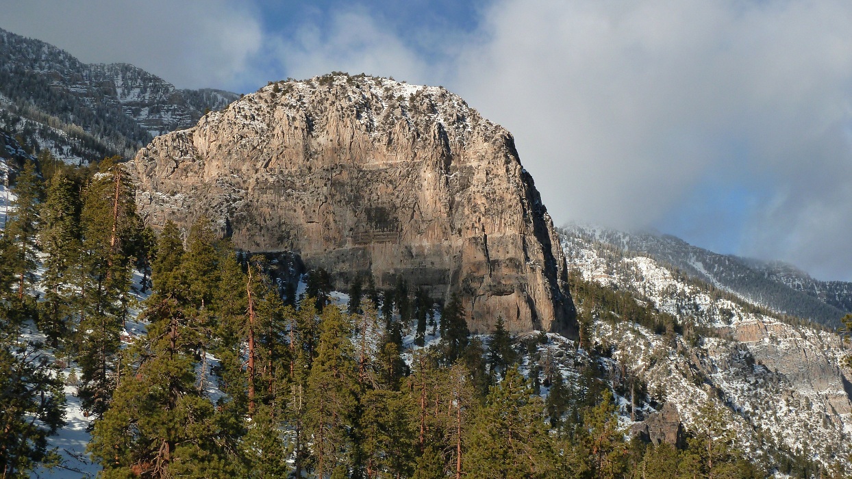
9,200 ft- clouds finally clearing from the peak

closeup of the peak

9,300 ft- looking NW

We started on the contour, following indents in the trees that looked like the trail, almost loosing it a few times. Because of the 30 degree slope, I had to angle my foot sideways, somewhat similar to side stepping with crampons. When the angle of the slope became more than 30 degrees, I faced uphill and dug only the front half of the snowshoes into the snow, front stepping in a sideways direction. I was postholing 6 inches into the snow even with the snowshoes on. The good thing about this was that the tracks would be clearly visible on the way back (unless the wind decided to come back). We climbed up a few switchbacks to a "Mt. Charleston Wilderness" sign. A few more switchbacks after that, we crossed a gully on what looked like a natural stone walkway buried in snow. We would refer to the preceding switchbacks as the "bridge switchbacks" on the way down the mountain. After the bridge, we were on north facing slopes. The snow lessened a little and tracks from previous climbers (although very faint), came back into view. We sere still postholing 5-7 inches, but now on gentler terrain. I made a mental note to prefer the E and S facing slopes to the NW and in case a wind came up.
looking back at the "bridge switchbacks" after crossing the gully, note the steeper NW slopes in the background

After a few switchbacks on this considerably easier terrain, we had a quick snack. Tommey pulled out his iPhone which indicated a linear half mile to the intersection with the ridge, which was probably more like 2 miles with all the switchbacks. The remaining switchbacks to the ridge were really straight forward, except when they would briefly cross over onto the NW slopes. As we climbed, the wind started increasing. It was directly hitting the NW slopes and occasionally making its way over to the N slopes. At 10,000 ft, we were getting hit with 45 mph winds from the NW. Spindrifts were coming off of the sides of Charleston Peak, meaning that the wind was much worse up there.
Charleston Peak with a spindrift on its north (right) side, photo from 10,000 ft

gentle switchbacks

view of Harris Mountain and Las Vegas

Griffith Peak comes into view. Every few minutes a big gust of wind would come along and envelop the peak in a giant spindrift. Every time I got out my camera to take a picture, the spindrift had ended.The areas near the ridge were stripped of their snow, indicating that this wind pattern had gone on all day long.

another view of Harris Mountain

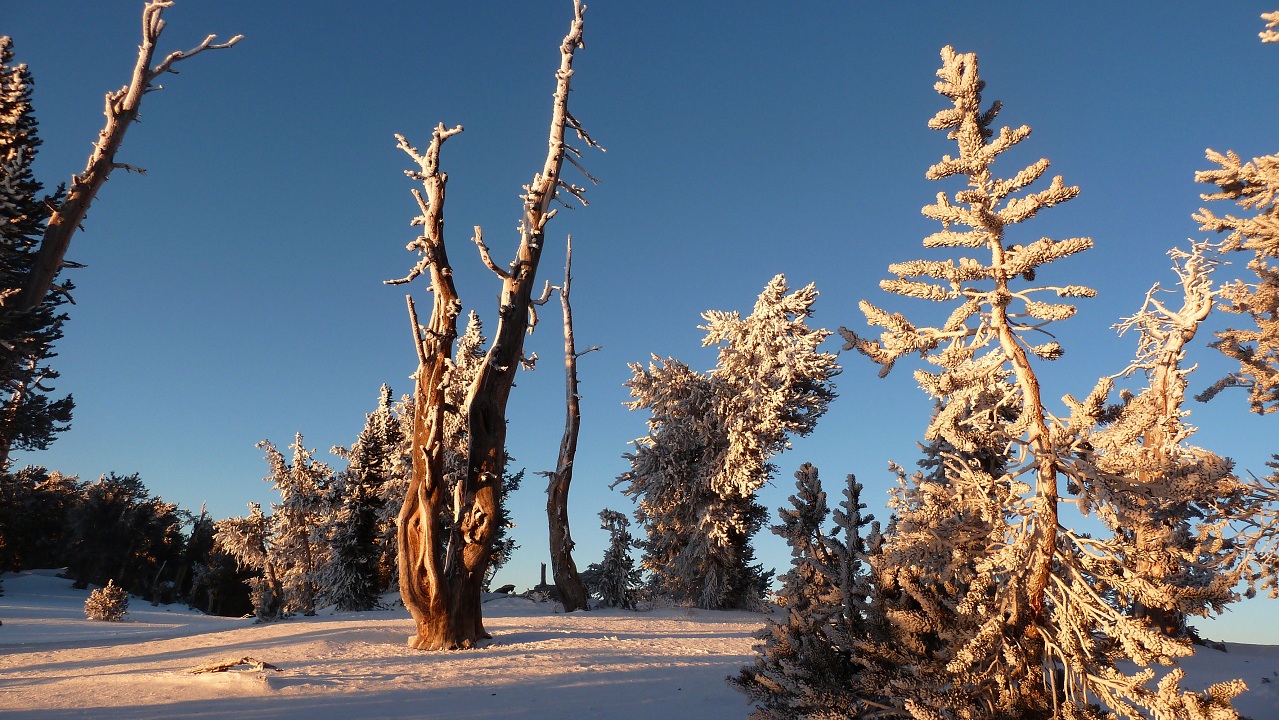
The wind picked up as the two of us reached the ridge intersection (10,740 ft). It seemed like we had stepped into a winter wonderland. Snow lay all along the ridge in deep drifts. The trees were coated with a intricate layer of rime ice, and the sun was shining brightly in the cloudless sky. It was just before 3pm, having taken us almost 6 hours to gain a measly 4,000 ft. It was slow going, but worth it. The place was so much more beautiful and peaceful in winter than it would be in summer. There was a wooden sign at the intersection, coated with rime ice. I chopped off the ice and took a picture. It was pretty obvious what direction we were going to be headed from here on.

The trail was supposed to contour over onto the south side of the ridge and gradually ascend to the summit. Both sides of the ridge looked like they were covered with a considerable amount of snow, which meant more postholing. We decided to stay on top of the ridge where the wind had blown off much of the snow. This meant more elevation gain, but requiring less energy because there wasn't too much snow. While the trail gradually ascended, the ridge consisted of a series of hills that we would have to climb up and down.The views from the ridge were awesome.

Mummy Mountain

drifts

up and down the ridge we go to Charleston

Charleston closeup

Mummy Mountain and Mummy's Toe (rock formation on the far right)

picturesque trees


wind picking up

towards the desert

looking back at Griffith Peak

We decided to stick with our primary objective- to summit Charleston Peak that night, probably arriving between 8pm and 9pm, which meant we were going to hike for at least 3.5 hours in the dark. Both of us had good flashlights, and the moon was supposed to be near full.
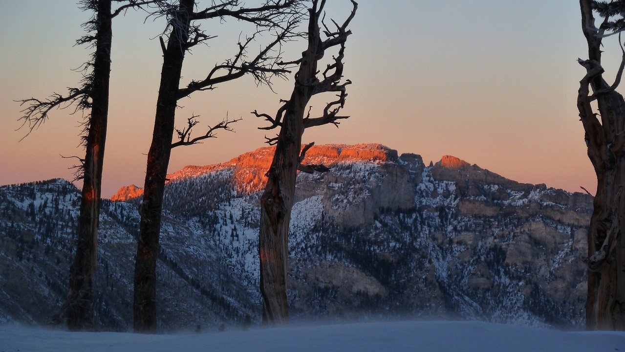
Mummy's Toe near sunset

very nice lighting


Just as the sun was going down, we noticed that several sections of the ridge ahead were piled deep with snow. We decided to drop down to the south (left) side of the ridge and follow a set of faint tracks. The postholing wasn't too bad- maybe about 4-5 inches with the snowshoes on. The tracks vanished in half a mile. We kept contouring the slope, aiming for a spot to the right of a false summit.
The night was very peaceful. The air was calm, stars filled the sky, and the moon shone brightly. I was eager to get above the treeline to the beautiful moonlit snowy terrain. The wind had completely stopped. I was thinking how nice it would be if conditions at the summit were like this too. Little did we know that the wind was getting stronger by the minute. It was now blowing directly from the north, slamming into the north slopes of the ridge. Since we were on the south side of the ridge, we were protected from the wind.
The temperature was somewhere in the high teens. I felt pretty warm. The snowshoes were now sinking deeper into the snow, and I had to work harder to break trail. I practiced delayering and relayering at certain points so I wouldn't sweat, which would be a real nuisance in case it got really cold. Tommey said he started to feel his energy deplete, so he munched on a Clif bar.
As we got closer to the false summit, we could hear a sound which gradually grew louder. It sounded like a freight train was crashing through the trees. It was the wind, now blowing at 50-55 mph. We climbed up briefly to the top of the ridge and was hit with an icy blast. The wind threw up several spindrifts, with stung as powdered snow pelted our faces. We dropped back down the south side of the ridge and resumed contouring. When we got above the treeline, the south side of the ridge was too steep for contouring, so we had no choice but to stay near the top of the ridge. We were now directly in the wind with no rocks or trees to shelter us. Spindrifts spun around us in all directions. The moon illuminated a saddle that was about half a mile away and 300 ft above us (which Ill refer to in this trip report as "little saddle"). That was just where we were supposed to be. It seemed like the wind was slamming onto the north side of the ridge, then blowing over the top and pressing down on parts of the south side that were close to the top of the ridge. I had to fight the wind to move uphill. Tommey was falling back. He said that his energy was depleting. There were numerous brown patches of scree and talus on the slopes. Wind had blown away a considerable amount of snow. The snowshoes made loud screeching noises as they came in contact with the rock. Just before we got to the saddle, Tommey looked at me and said that we might want to consider calling it for the night and finding an area to set up camp. The choice was mine. I told him that I wanted to get up to the saddle and see how far away the peak looked, then make a decision.
I got up to the saddle and looked around. It was very hard to look around as every few seconds I would be engulfed in a spindrift and my face would get blasted with a mix of powdery snow and dirt. Small pebbles were even getting lifted up and scattered. The peak didn't look far, maybe a little over a mile. But the wind was so strong (~65 mph) that I didn't know if we could traverse the ridge. Because the false summit blocked much of my view towards the west, I could only see the north side of the ridge leading up Charleston. The north side had less snow than where I was currently standing, meaning that the wind must be much stronger there. There was a lower, bigger saddle to my left (which I will simply refer to as "Big Saddle for this trip report.) I wanted to contour around the false summit to Big Saddle, where I would get a view of the rest of the ridge to Charleston. Tommey came staggering up to the saddle a few minutes later. He took a look at the peak and said that he would follow my decision- "Lets go for it."
I decided to go for the summit for two reasons:
1. Because we were protected from the wind on the south side of the ridge for the past few miles, I assumed that the south side of the following ridge would be protected. We just had to traverse around the false summit and take a look at it. The more snow there was on the side, the less wind there would be.
2. I was pretty much convinced at this point that the summit would be in the wind by now. I was hoping to reach the wind shelter just below the summit. Once we were in, we would be golden.
The wind seemed to grow even stronger as we traversed around the false summit. It came slamming down on us from the top of the ridge, continuously pelting us with snow and dirt. The air temperature was around 15F. I estimated the wind to be blowing at an average of 65 mph. Occasional gusts of 75 mph were making their way over the ridge. I later calculated the average wind chill factor to be -12F (-13F in gusts). According to Weather.com, the direct skin exposure frostbite time is 10 minutes. We staggered across the immediate south slope of the false summit, constantly getting blown over by wind. It took us about 20 minutes to gain the 1000 ft of distance to the other side of the hill, about 30 ft above Big Saddle. When I reached it, I had an expansive view of both sides of the ridge that lay before us. It was a sight I had never seen before. The remaining part of the ridge angled several more degrees to the north. This meant that the side of the ridge I had thought was facing south was actually facing closer to the west. It looked like the wind was coming out of the NE. There was no higher point between the false summit and the actual summit, which were located about half a mile apart. The wind slammed onto the NE side of the ridge, and, being blocked by the false summit, proceeded to angle SW. This created a wind tunnel in between the summits, where wind speeds would easily be reaching speeds as high as 110 mph.
The moon lit up the whole scene so that I could see it almost as if it were daytime. The SW facing slope of the ridge was almost totally stripped of its snow. The remaining snow was lifted up and thrown hundreds of feet into the air as giant, whirling spindrifts. These spindrifts were blown off the SW side of the ridge, resembling a gigantic waterfall. Great clouds of snow partially obscured the summit at times. In some areas, the ground would blur and what looked like black snow was also being lifted up. It occurred to me that the wind must have been lifting up rocks along with snow. They must have been big, as I could easily spot them from over a half mile away. The sound was deafening, several times louder than that of a freight train.
A stray gust of wind slammed into me and knocked me over. I hit the ground and skidded a few feet back. This was it. I struggled back to Tommey and shouted to turn back. Back across the hill we went, slipping, sliding, falling, and pelted by snow and small rocks. I steered down the slope towards the trees, hoping to get to the protection of the south side of the ridge. I was still hoping to come back the next day and try for the summit if the wind was calm. Tommey was not happy about my "keep going" decision. He planned to hike back as far as his legs would carry him, get to some flat ground that was out of the wind, and set up camp. Even if it was calm and sunny the next morning, he didn't care about the summit. He said that he was getting off the mountain, and I could do whatever I want. This left me no choice but to head back too. I didn't want to risk soloing the climb when there wasn't a single person on the entire mountain.
route overview of the last bit of traverse before we turned back

We reached a flat spot on the south side of the ridge probably around 9pm and decided to camp there. I was glad to drop my heavy pack. The wind had subsided to a 5 mph light breeze. We got out our shovels and begun digging a snow shelter, then set up the tent. Tommey hadn't had any water for the past few hours. He took out a bottle of water drank a few gulps of slush that hadn't frozen yet. All my water bottles were completely frozen so I boiled snow. We passed the Jetboil back and forth, taking sips. After a few sips, Tommey mentioned he wasn't thirsty. He was so tired that he just wanted to go to sleep. It struck me as unusual how little water he drank. As he was getting out his sleeping bag, I heard an "on shit." He had forgotten his food bag back at the car, bringing only a couple energy bars and a bag of trail mix. I had a mostly full can of spam, a few Clif bars and Gu packets, and a Mountain House Beef Stroganoff, which should be sufficient to get us both off the mountain. None of us cared about food at the moment. We just wanted to rest. Probably some Beef Stroganoff in the morning.
I crawled into my sleeping bag. The warmth felt good and I began to feel sleepy after a few minutes. Tommey suddenly said that he was shivering violently and uncontrollably. His hands and feet were ok but his core temperature was dropping. He said that either the sleeping bag wasn't working or he was not generating any body heat. Over the next few minutes, I noticed that his speech was growing shaky and he was making several awkward groaning sounds. This had to be some form of hypothermia. I unzipped my sleeping bag and wrapped myself around Tommey, then threw the unzipped sleeping bag over both of us like a blanket. The shivering and jerky movements went on for the next 15 minutes and then subsided. In another 15 minutes, Tommey was starting to talk again, saying that his core temperature felt back to normal. I gladly crawled back into my sleeping bag. Laying in that awkward position had made my legs cramp up a little.
We fell asleep shortly after and woke up in the wee hours of the morning. The wind was blowing at about 30 mph outside. It blew rime ice off the trees, which made clunking sounds when it would hit the tent. Every so often a large piece would hit the tent and startle us for a split second. I slept through most of it, waking up only once more before sunrise.
The first thought that hit me when I woke up at sunrise was that there was no wind. Everything stood completely still. A few birds were chirping. A layer of cirrus clouds had moved in overnight, insulating the air. The air felt surprisingly warm, with temperatures in the high teens. Tommey said that he felt energetic and was up for going to the peak. I gladly agreed. First things first. We needed to eat and boil snow. Even though we felt energetic, it was very likely that our bodies were running off of glycogen, which doesn't last long. We divided the Beef Stroganoff and munched on some crackers and energy bars. Tommey took a photo of me in the tent.
Evidently, we were very organized campers last night.

We took down the tent and packed away everything we didn't need, leaving the full packs behind a nearby tree. We would collect them on the way back. Each of us brought a couple liters of water and some energy bars. We were both surprised at the time it took is to get to the point where we turned back yesterday- 45 minutes. It had taken well over 2 hours the previous day. The wind had turned into a gentle breeze. The only evidence that there had been a windstorm the previous night were the brown patches stripped of snow. From Big Saddle, we could see Charleston Peak not too far away. It didn't look like snowshoes would be needed anymore, so we dropped ours.
Charleston Peak from Big Saddle

amount of snow compared to the previous day

view SW

view S

At first, we stayed on the trail, but a ridge looked more fun.


Just keep following the ridge to the summit


I was dismayed to see that the summit was ruined by a radio tower and what looked to be some kind of storage tank. Otherwise, it was a beautiful clear day. It was very peaceful. The two of us were probably the only ones on the mountain that day.
summit

views from summit


looking back to where we came from- Griffith Peak is the highpoint at the end of the ridge

descending

nice layers

We got back to camp and ate the last of the Spam. Our remaining food consisted of a couple energy bars and a little bit of trail mix. Surprisingly, my full pack didn't seem that heavy. The trek back across the ridge was uneventful. Clouds were starting to move in, signaling an oncoming storm. Up and down on the ridge we climbed. There was less snow on the ridge than there was yesterday, owing to the previous night's wind, so we were able to make better time with less postholing.


When we got back to the ridge intersection, I decided to grab Griffith Peak really quick. It was about a half mile further along the ridge. Tommey said that he would start descending and meet me down the mountain. I dropped my pack at the intersection and started forward, bringing nothing but my camera. The Spam had really kicked in and my energy levels were soaring. I half jogged most of the way up Griffith Peak. The snow turned out to be firmer at the top of the ridge, where my snowshoes made a chomping sound every time they hit the ground. I made it to the top of Griffith 17 minutes after leaving the intersection.
Griffith Peak- a few minutes after the intersection

looking back at Charleston Peak from just below the summit of Griffith

Griffith Peak summit views


summit register

I signed the register and enjoyed the view for about 10 minutes. The bottoms of the clouds to the west looked like they were lowering, indicating oncoming snow showers. They were approaching fast. I descended back to the intersection in 18 minutes- a minute longer than my ascent time due to the fact that its very hard to run downhill in snowshoes. By the time I reached the intersection, the snow showers had already engulfed Mummy Mountain and the upper reaches of Charleston.
light snow shower falling over Mummy Mountain

It looked like the wind had blown away our tracks from the previous day due to Tommey's tracks wandering this way and that. I followed them for about 20 minutes before reaching him. The snow was pure powder, and Tommey had postholed up to 10 inches deep while breaking trail. Down we went, with Tommey breaking trail. A few light snow flurries fell here and there. We were descending fast, wanting to make it to the bridge switchbacks before it got completely dark. I was becoming aware that my my arms and legs were getting that "sour" feeling from dehydration, but was concentrated on the descent so I stupidly ignored it and did not drink any water. The full effect of it hit me when we got to the bridge switchbacks. I felt slightly nauseated and didn't want to move my arms and legs. I realized that this was bad dehydration and begun taking small sips of water. This was a slightly difficult process as I did not feel a bit thirsty, the water was bitter cold, and ever time I took a sip, I would burp and feel like puking for a few seconds I forced myself to drink more, as this was the only way to cure my symptoms. I started feeling better, but very gradually. I could not risk drinking a lot of water at once for the fear of creating an imbalance in my stomach and puking out the energy I needed to get off the mountain.
When we finally got to the bridge switchbacks, the flashlights were on. I felt like throwing my sleeping bag on the snow and just laying there for a few hours. Tommey begun sidestepping, breaking trail on the next few arduous switchbacks which consisted of contouring the side of a 30-35 degree slope. There was less powder here and we were left with semi icy snow. We kicked in the snowshoes extra hard. It took about 40 minutes to get down three switchbacks Tommey said that he was starting to feel the exhaustion kick in. When we finally reached the end of the switchbacks, I sat down and slowly ate a Clif bar.
Down we went. There were only 2.5 miles and 1,800 ft to descend, but I felt ready to drop. A quarter mile later, Tommey took off his snowshoes. I sat down gratefully We walked another half mile and Tommey suggested that boiling snow would probably make the water more drinkable. he pulled out his Jetboil and begun scooping up snow.
Immediately after my first sip of warm water, my sense of thirst returned. I drank almost the entire thing in about 30 seconds We boiled some more to use on the way down and then packed up. 10 minutes later, I felt dramatic improvements The nausea had gone and the feeling of lemon juice in my arms and legs had subsided. I knew I was back to normal when I started noticing the surroundings again. The clouds had partially cleared and the full moon was out. The trail in front of us was lit up brightly, so the flashlights went off. A few tracks from the previous day remained in the snow.
The moon was still shining brightly when we got to the road, only a half mile walk and a climb around a gate from the car. We had a surprise waiting for us at the gate. Someone had dug under it, allowing us to crawl under.
Stats
Total round trip miles: 18.5 mi
Total elevation gain/loss: 6,700 ft/ -6,700 ft

No comments:
Post a Comment